Texas winter wx thread (2009-2010)

Winter Weather Discussion

Moderator: S2k Moderators

Forum rules

The posts in this forum are NOT official forecast and should not be used as such. They are just the opinion of the poster and may or may not be backed by sound meteorological data. They are NOT endorsed by any professional institution or STORM2K.

Help Support Storm2K
Message
Author
Weatherdude20

Re: Texas winter wx thread (2009-2010)

#4741 Postby Weatherdude20 » Thu Jan 28, 2010 10:28 am

I'm right with you Captian Crunch, but I would disagree on one note....

I would issue a Winter Weather Advisory for Denton County, Parker and Tarrant.

Probably not Dallas, I would trdade that idea out for Parker county... :wink:

And btw, the cold front is making major progress and WILL effect the NWSFO's forecast, because temps are:

Decatur 44, Lt rain.
Denton 45, North Wind 18mph
Gainesville 38, Lt Rain.
0 likes   

User avatar
TexasStorm
Tropical Storm
Tropical Storm
Posts: 174
Joined: Wed Jul 16, 2008 10:00 am
Location: North Texas

Re: Texas winter wx thread (2009-2010)

#4742 Postby TexasStorm » Thu Jan 28, 2010 10:28 am

The NWS Fort Worth in their latest discussion expects the front to stall for a bit up around the Red River and not come through DFW until later tonight.
0 likes   

User avatar
wxman57
Moderator-Pro Met
Moderator-Pro Met
Posts: 22986
Age: 67
Joined: Sat Jun 21, 2003 8:06 pm
Location: Houston, TX (southwest)

Re: Texas winter wx thread (2009-2010)

#4743 Postby wxman57 » Thu Jan 28, 2010 10:30 am

Since I figure some of you would like to easily make your own meteograms here, I'll post the instructions and a link to the spreadsheet I'm using.

Get Raw Data:
1. Go to the ARL website: http://ready.arl.noaa.gov/READYcmet.php

2. Type in an airport identifier or the latitude/longitude of the place you want to generate the meteogram for. For our hemisphere, you need to input your longitude as a negative value. I.E. -95.0 for 95W.

3. Click "Continue"

4. On this page, you choose your model. On the "METEOGRAM" line click the drop-down menu next to the "GO" button to select the "GFS Model (0-180h 3hrly Global). and click "GO"

5. On this page, the current/latest model run is selected by default. If that's ok, click "Next". if not, select an earlier model run with the drop-down menu.

6. Now you're on a page with lots of "stuff", but it's easy to navigate as you only have to edit 3 fields. In the top box next to "Fields to plot:", click the radio button that says "Choose From Below".

7. In the "Field 1" box, select "Temperature - 2 meters AGL (SFC)"

8. In the "Field 2" box, select "Accumulated Precipitation (SFC)"

9. Scroll to the bottom of the page and type in the group of letters you see in the gray box (to prove you're human) and click "Get Meteogram".

10. You now have a meteogram generated but it's two different graphics and temperature values are on deg. C with 10 degree increments. Not very pretty. At the very bottom of the page click "Text Results".

11. A box will pop up and it'll ask you what program that you want to use to open the text file. Choose WORDPAD (not notepad or Word, WORDPAD). The text file will now open.

12. Now you need to open the Excel spreadsheet to get it ready to paste in the data:
http://myweb.cableone.net/nolasue/Meteogram.xls <-- you may have to right click on this link and "Save target as" to put it on your hard drive. I saved it as an Office 2003 file for those of you without Office 2007.

13. Back to the text file. Highlight all 4 columns starting with your cursor just left of the "+" sign next to the 0 hour and drag your mouse to the bottom. You should ONLY have highlighted the numbers, NOT the column headers. Right-click on the highlighted area and select "Copy".

14. Go the spreadsheet and click the "RAW" tab on the bottom. Left click in the cell "F1". There should be a zero in that box. Now right-click and select "Paste".

15. Now you need to sort the newly-pasted data into columns and replace the old data. This step may be a bit different for those of you with Office 97, but you should be able to figure it out. At the top toolbar in Excel, click "Data" then select "Text to Columns" in the ribbon toolbar (Excel 2007).

16. Click "Finish" in the box that pops up and then "OK" to confirm that you want to replace the old data. You're almost done now!

17. To make the date/time groups at the bottom of the graphic apply to the CURRENT model run that you just pasted in there, click the "Data" tab at the bottom of your Excel document. Click the very top date/time group (cell B2) and edit it for the appropriate date and time. I have it set to Central Standard Time.

18. Click the "Temps and Precip" tab at the bottom of the spreadsheet to view your meteogram. You can then click on the graph title at the top and change it to the correct date/time and location.

That's it! 18 steps but it really goes fast once you do it a few times. I can make a meteogram in under a minute.

Oh, and from the same spreadsheet you can also make one that works with the NAM. You just have to go to the "Data" tab and "Raw" tab and delete all the rows after 84 hrs then save the spreadsheet as a different name so you won't overwrite the original one that works for the GFS. For the NAM, I use the "Nam Model (40 km over US)".
Last edited by wxman57 on Thu Jan 28, 2010 10:34 am, edited 1 time in total.
0 likes   

Weatherdude20

Re: Texas winter wx thread (2009-2010)

#4744 Postby Weatherdude20 » Thu Jan 28, 2010 10:33 am

TexasStorm wrote:The NWS Fort Worth in their latest discussion expects the front to stall for a bit up around the Red River and not come through DFW until later tonight.


Hahaha where have you been its already in Denton, Decatur line?

Jk
0 likes   

User avatar
CaptinCrunch
S2K Supporter
S2K Supporter
Posts: 8731
Age: 57
Joined: Mon Nov 03, 2003 4:33 pm
Location: Kennedale, TX (Tarrant Co.)

Re: Texas winter wx thread (2009-2010)

#4745 Postby CaptinCrunch » Thu Jan 28, 2010 10:36 am

TexasStorm wrote:The NWS Fort Worth in their latest discussion expects the front to stall for a bit up around the Red River and not come through DFW until later tonight.


Well that went out the window since the front is already south of the Denton airport :ggreen:
0 likes   

User avatar
srainhoutx
S2K Supporter
S2K Supporter
Posts: 6919
Age: 67
Joined: Sun Jan 14, 2007 11:34 am
Location: Haywood County, NC
Contact:

Re: Texas winter wx thread (2009-2010)

#4746 Postby srainhoutx » Thu Jan 28, 2010 10:37 am

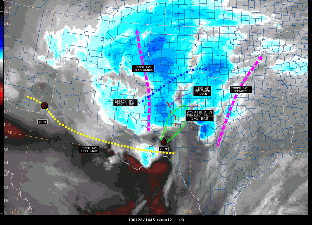
I'll repost this here as well...

ZCZC NFDSPENES ALL
SPENES
TXZ000-OKZ000-
.
SATELLITE PRECIPITATION ESTIMATES..DATE/TIME 01/28/10 1509Z
SATELLITE ANALYSIS BRANCH/NESDIS---NPPU---TEL.301-763-8678
LATEST DATA USED: GOES-12: 1445Z DS
.
LOCATION...W/CENTRAL TEXAS...S/EXTREME SW OKLAHOMA...
.
ATTN WFOS...FWD...OUN...EWX...SJT...LUB...MAF...
ATTN RFCS...ABRFC...WGRFC...
.
EVENT...MOD-HVY RAINFALL
.
SATELLITE ANALYSIS AND TRENDS...WV IMAGERY SHOWS AN ELONGATED UPPER LVL
S/WV TROF ROTATING NEWD FROM MX WITH TWO SMALL EMBEDDED VORTS. A WIDE
AREA OF DIFFLUENT FLOW ALOFT RUNNING FROM NE NM TO ERN OK/CENTRAL TX IS
EVIDENT IN WV AS WELL. IR IMAGERY HAS DEPICTED COOLING CLOUD TOPS TO -63C
WITHIN THIS DIFFLUENT FLOW OVER THE PAST 1-2 HRS AS CNVTN HAS INTENSIFIED
ACROSS PARTS OF W/W CENTRAL TX AND THE SRN TX PANHANDLE. MOST PROMINENT
IS A THIN LINE OF CNVTN/HVY RAINFALL FROM BORDEN TO IRION COUNTIES WHILE
ELSEWHERE RAINRALL ACROSS W CENTRAL TX..RAINFALL HAS BEEN MORE MOD IN
INTENSITY WITH PRECIP CHANGING OVER TO FREEZING RAIN N OF A LINE ROUGHLY
FROM KHOB IN NM PASSING JUST S OF LBB TO EXTREME SW OK.
.
STRONGEST SFC MOISTURE CNVG..CURRENTLY CENTERED JUST W OF SJT..HAS
BEEN CONCENTRATED JUST AHEAD OF A SFC LOW OVER W TX. VIS/RADAR IMAGERY
BOTH SHOW NEW CNVTN BEGINNING TO DVLP OVER PARTS OF TERRELL/CROCKETT
COUNTIES WITH ADDTL TSTORMS LIKELY TO FOLLOW NEWD FROM SRN PRESIDIO/SRN
BREWSTER COUNTIES. VIS SHOWS SVRL OVERSHOOTING TOPS ASSCD WITH THIS
GROWING CNVTN..INDICATING STRONG POTENTIAL FOR HVY RAINFALL AS THESE
CELLS MATURE. 1" OR GREATER PW VALUES BEING LIFTED NWD BY SRLY/SSERLY LL
FLOW WILL CONTINUE TO FEED INTO THE GROWING TSTORMS. IN THE NEXT 1-1.5
HRS..THE GREATEST FF THREAT WILL LIKELY BE OVER CROCKETT/IRION/WRN TOM
GREEN/STERLING/GLASSCOCK/REAGAN COUNTIES SINCE THE MAIN LINE OF CNVTN
IS CURRENTLY OR HAS RECENTLY PASSED THROUGH THOSE COUNTIES AND NEW
GROWING CNVTN IS/WILL AGAIN CROSS THOSE SAME AREAS. THE FF THREAT WILL
LIKELY THEN SPREAD OUT TO THE NE FROM THOSE COUNTIES. RAINRATES AROUND
AND SOMETIMES ABOVE 1"/HR WILL BE POSSIBLE ACROSS THE ABOVE DESCRIBED
AREA. PLEASE SEE WEB ADDRESS SHORTLY FOR GRAPHIC ANALYSIS.
.
SEE NCEP HPC DISCUSSION AND QPF/S FOR FORECAST.
....NESDIS IS A MEMBER OF 12 PLANET....
.
SSD/SAB WEB ADDRESS FOR PRECIP ESTIMATES:
HTTP://WWW.SSD.NOAA.GOV/PS/PCPN/
...ALL LOWER CASE EXCEPT /PS/PCPN/
.
LAT...LON 3472 9923 3400 9734 3120 9765 2784 10360 2944 10489
3130 10271 3319 10279
Image
0 likes   
Carla/Alicia/Jerry(In The Eye)/Michelle/Charley/Ivan/Dennis/Katrina/Rita/Wilma/Ike/Harvey

Member: National Weather Association
Wx Infinity Forums
http://wxinfinity.com/index.php

Facebook.com/WeatherInfinity
Twitter @WeatherInfinity

User avatar
Portastorm
Storm2k Moderator
Storm2k Moderator
Posts: 9914
Age: 63
Joined: Fri Jul 11, 2003 9:16 am
Location: Round Rock, TX
Contact:

Re: Texas winter wx thread (2009-2010)

#4747 Postby Portastorm » Thu Jan 28, 2010 10:38 am

For those who do not experience winter weather, like me, and like to live vicariously through webcams. Here's some road shots from Amarillo. Already looking bad.

http://amaits.dot.state.tx.us/AMA-ITS/default.htm
0 likes   

msstateguy83

Re: Texas winter wx thread (2009-2010)

#4748 Postby msstateguy83 » Thu Jan 28, 2010 10:39 am

all kidding aside this is fixing to turn into one BIG BIG disastrous ice storm for central into swrn ok and i think now nw tx...
up and down i-44 from okc to lawton to w.falls either side of 44 by about 50-60 miles i would say ruffly i would think ice
amounts could top 1"
0 likes   

msstateguy83

Re: Texas winter wx thread (2009-2010)

#4749 Postby msstateguy83 » Thu Jan 28, 2010 10:41 am

OUN EXPANDING WINTER STORM WARNING..
0 likes   

User avatar
CaptinCrunch
S2K Supporter
S2K Supporter
Posts: 8731
Age: 57
Joined: Mon Nov 03, 2003 4:33 pm
Location: Kennedale, TX (Tarrant Co.)

Re: Texas winter wx thread (2009-2010)

#4750 Postby CaptinCrunch » Thu Jan 28, 2010 10:42 am

Weatherdude20 wrote:I'm right with you Captian Crunch, but I would disagree on one note....

I would issue a Winter Weather Advisory for Denton County, Parker and Tarrant.

Probably not Dallas, I would trdade that idea out for Parker county... :wink:

And btw, the cold front is making major progress and WILL effect the NWSFO's forecast, because temps are:

Decatur 44, Lt rain.
Denton 45, North Wind 18mph
Gainesville 38, Lt Rain.


I expect it to include Parker, Tarrant, Dallas and Countys to the north all the way to the Red River.
0 likes   

msstateguy83

Re: Texas winter wx thread (2009-2010)

#4751 Postby msstateguy83 » Thu Jan 28, 2010 10:42 am

AREA FORECAST DISCUSSION
NATIONAL WEATHER SERVICE NORMAN OK
939 AM CST THU JAN 28 2010

.UPDATE...
WILL BE EXPANDING THE WINTER STORM WARNING FARTHER SOUTH AS COLD
LOW-LEVEL AIR CONTINUES TO SPREAD SOUTH... WHICH WILL LEAD TO
CHANGE TO FREEZING RAIN LATE THIS MORNING OR THIS AFTERNOON ACROSS
AREAS JUST SOUTH OF THE CURRENT WARNING. AS COLD AIR CONTINUES TO
SPREAD SOUTH AND DEEPEN... WE ARE GETTING REPORTS OF MIX OR
CHANGE-OVER TO SLEET IN HOBART AND THE NORTHWEST OKC METRO. DRY
LOW-LEVEL AIR IS FILTERING INTO THE AREA /DEWPOINT DEPRESSIONS
ARE 5 TO 15 DEGREES ACROSS MUCH OF CENTRAL AND NORTHERN OKLAHOMA
IN THE COOL AIRMASS/... WHICH SHOULD CONTINUE TO COOL THE NEAR-
SURFACE COLD LAYER AND MAY ALLOW MORE AREAS TO MIX WITH OR CHANGE
TO SLEET THIS AFTERNOON AS OPPOSED TO FREEZING RAIN
0 likes   

User avatar
wxman57
Moderator-Pro Met
Moderator-Pro Met
Posts: 22986
Age: 67
Joined: Sat Jun 21, 2003 8:06 pm
Location: Houston, TX (southwest)

Re: Texas winter wx thread (2009-2010)

#4752 Postby wxman57 » Thu Jan 28, 2010 11:00 am

TexasStorm wrote:The NWS Fort Worth in their latest discussion expects the front to stall for a bit up around the Red River and not come through DFW until later tonight.


I don't see where it says exactly that. Here's the latest discussion (they didn't update the discussion on the front at 9am):

.PREV DISCUSSION... /ISSUED 455 AM CST THU JAN 28 2010/
COLD FRONT OOZED INTO SOUTHERN OKLAHOMA OVERNIGHT...AND WILL PUSH
ACROSS THE RED RIVER THIS MORNING. FORWARD MOTION WILL BE SLOW
UNTIL UPPER LOW APPROACHES LATE IN THE DAY.

Now, the really cold air is still up along the Red River (near freezing), but the diffuse frontal boundary is in the Denton area, just north of D-FW now. Wind behind the front is out of the NE-ENE, so southward progress through Dallas will be slow.

Oh, here's a spreadsheet that works for the NAM (vs. the GFS one I posted earlier). Procedures are the same:
http://myweb.cableone.net/nolasue/MeteogramNAM.xls <-- right click and "Save as"

Note: I had made a 12Z NAM meteogram for Dallas but the data are not fully in yet so it looked "strange" and I removed the image.
0 likes   

HockeyTx82
S2K Supporter
S2K Supporter
Posts: 2541
Joined: Tue Oct 27, 2009 11:17 am
Location: Ponder, TX

Re: Texas winter wx thread (2009-2010)

#4753 Postby HockeyTx82 » Thu Jan 28, 2010 11:07 am

Yeah, I walked outside about 30min ago to another building on the UNT campus. When I came back out the air felt much colder.
0 likes   
Don't hold me accountable for anything I post on this forum. Leave the real forecasting up to the professionals.

Location: Ponder, TX (all observation posts are this location unless otherwise noted)

rhoby13
Tropical Low
Tropical Low
Posts: 31
Joined: Thu Dec 03, 2009 4:02 pm
Location: Austin, TX

Re: Texas winter wx thread (2009-2010)

#4754 Postby rhoby13 » Thu Jan 28, 2010 11:14 am

I noticed NWS Austin has changed it's forecast to include possible sleet.

DISCUSSION...
STRONG 500 HPA LOW OVER THE SOUTHWEST U.S. AND NORTH CENTRAL MEXICO
IS FORECAST TO MOVE ON AN EAST NORTHEAST TRACK THROUGH FRIDAY.
EXPECT OCCASIONAL RAIN TODAY THROUGH TONIGHT...WITH RAIN AND
SHOWERS THIS MORNING CHANGING OVER TO SHOWERS OR THUNDERSTORMS
THIS AFTERNOON...AS MORE UNSTABLE CONDITIONS DEVELOP. AS THE
STORM SYSTEM TO THE WEST GETS CLOSER TO SOUTH CENTRAL TEXAS
IN THE AFTERNOON THROUGH THE EVENING MENTIONED MORE SHOWERS
AND THUNDERSTORMS POSSIBLE. A FEW OF THE THUNDERSTORMS COULD
BECOME SEVERE LATE THIS AFTERNOON OR EVENING TO LATE TONIGHT. THIS
UNSTABLE PATTERN HAS BEEN SHOWN BY FORECAST SOLUTIONS THE PAST FEW
DAYS AND ALSO IN SPC DISCUSSIONS. THE MAIN CONCERNS FOR ISOLATED
THUNDERSTORMS THAT COULD BECOME SEVERE WOULD BE HAIL AND STRONG
WINDS. A COLD FRONT MOVING ACROSS SOUTH CENTRAL TEXAS WILL ALSO
ACT AS A FOCUS FOR THUNDERSTORMS TO DEVELOP. IN ADDITION MENTIONED
LOCALLY HEAVY RAIN OVER THE EAST HALF OF SOUTH CENTRAL TEXAS FOR
TONIGHT AND ON FRIDAY MORNING OVER THE EAST TO SOUTHEAST PART OF
SOUTH CENTRAL TEXAS...OVER THE COASTAL PLAINS. AS CONDITIONS GET
COLDER EARLY FRIDAY MORNING...COLD RAIN WITH SHOWERS IS EXPECTED.
THERE COULD BE SOME SLEET MIXED WITH THE COLD RAIN ALONG AND NORTH
OF A LINE FROM FREDERICKSBURG TO SAN MARCOS TO LA GRANGE IN THE
EARLY MORNING AROUND AND JUST AFTER SUNRISE FOR A FEW HOURS
. THE
COLD RAIN AND SHOWERS WILL MOVE TO THE EAST PART OF SOUTH CENTRAL
TEXAS BY EARLY AFTERNOON AND EAST OF THE AREA IN THE MID TO LATE
AFTERNOON...AS DRIER AND COLD CONDITIONS MOVE ACROSS THE REGION
FROM THE WEST.
0 likes   

Weatherdude20

Re: Texas winter wx thread (2009-2010)

#4755 Postby Weatherdude20 » Thu Jan 28, 2010 11:16 am

Decatur 44, Lt rain.
Denton 45, North Wind 18mph
Gainesville 38, Lt Rain.


Decatur 38
Denton 42
Gainesville 37
Jacksboro 43


33 in Wichita Falls! :D
0 likes   

User avatar
wxman57
Moderator-Pro Met
Moderator-Pro Met
Posts: 22986
Age: 67
Joined: Sat Jun 21, 2003 8:06 pm
Location: Houston, TX (southwest)

Re: Texas winter wx thread (2009-2010)

#4756 Postby wxman57 » Thu Jan 28, 2010 11:16 am

Note that I just made a slight correction to both meteogram spreadsheets to make the precip units on the right side line up properly. Here are the new spreadsheets:

http://myweb.cableone.net/nolasue/Meteogram.xls <-- right click and save target as

http://myweb.cableone.net/nolasue/MeteogramNAM.xls
0 likes   

User avatar
CaptinCrunch
S2K Supporter
S2K Supporter
Posts: 8731
Age: 57
Joined: Mon Nov 03, 2003 4:33 pm
Location: Kennedale, TX (Tarrant Co.)

Re: Texas winter wx thread (2009-2010)

#4757 Postby CaptinCrunch » Thu Jan 28, 2010 11:19 am

wxman57 wrote:
TexasStorm wrote:The NWS Fort Worth in their latest discussion expects the front to stall for a bit up around the Red River and not come through DFW until later tonight.


I don't see where it says exactly that. Here's the latest discussion (they didn't update the discussion on the front at 9am):

.PREV DISCUSSION... /ISSUED 455 AM CST THU JAN 28 2010/
COLD FRONT OOZED INTO SOUTHERN OKLAHOMA OVERNIGHT...AND WILL PUSH
ACROSS THE RED RIVER THIS MORNING. FORWARD MOTION WILL BE SLOW
UNTIL UPPER LOW APPROACHES LATE IN THE DAY.

Now, the really cold air is still up along the Red River (near freezing), but the diffuse frontal boundary is in the Denton area, just north of D-FW now. Wind behind the front is out of the NE-ENE, so southward progress through Dallas will be slow.

Oh, here's a spreadsheet that works for the NAM (vs. the GFS one I posted earlier). Procedures are the same:
http://myweb.cableone.net/nolasue/MeteogramNAM.xls <-- right click and "Save as"

Note: I had made a 12Z NAM meteogram for Dallas but the data are not fully in yet so it looked "strange" and I removed the image.


says right here

OTHERWISE WE SHOULD SEE IFR CIGS FOR ALL TAF SITES BY THIS
AFTERNOON...AND THEN IFR VSBYS AS RAIN INTENSIFIES AS THE COLD
FRONT BEGINS TO MOVE SOUTHEAST THROUGH NORTH TX AFTER SUNSET.
TIMING OF FROPA LOOKS TO BE SIMILAR TO 06Z ISSUANCE...SO NO
CHANGES THERE.


and they way off front just about to DFW airport now, as I'm watching the flags on out pole out front and they are starting to wont to make that turn to the south.
0 likes   

User avatar
wxman57
Moderator-Pro Met
Moderator-Pro Met
Posts: 22986
Age: 67
Joined: Sat Jun 21, 2003 8:06 pm
Location: Houston, TX (southwest)

Re: Texas winter wx thread (2009-2010)

#4758 Postby wxman57 » Thu Jan 28, 2010 11:23 am

CaptinCrunch wrote:
says right here

OTHERWISE WE SHOULD SEE IFR CIGS FOR ALL TAF SITES BY THIS
AFTERNOON...AND THEN IFR VSBYS AS RAIN INTENSIFIES AS THE COLD
FRONT BEGINS TO MOVE SOUTHEAST THROUGH NORTH TX AFTER SUNSET.
TIMING OF FROPA LOOKS TO BE SIMILAR TO 06Z ISSUANCE...SO NO
CHANGES THERE.


and they way off front just about to DFW airport now, as I'm watching the flags on out pole out front and they are starting to wont to make that turn to the south.


Clearly, the leading edge of colder air is nearly at Dallas-Ft. Worth. However, the leading edge of the very cold air (low-mid 30s) is still well to the north along the Red River. Maybe that's what they're talking about?
0 likes   

WeatherKing
Tropical Low
Tropical Low
Posts: 30
Joined: Thu Jan 28, 2010 11:21 am
Location: DFW

Re: Texas winter wx thread (2009-2010)

#4759 Postby WeatherKing » Thu Jan 28, 2010 11:24 am

:cold: Denton was supposed to drop to 46 at 5pm, that is out the window. Will the heavy precipitation drag warm air down however?
Last edited by WeatherKing on Thu Jan 28, 2010 11:25 am, edited 1 time in total.
0 likes   

shibumi
Tropical Depression
Tropical Depression
Posts: 66
Joined: Tue Jan 29, 2008 1:42 pm

Re: Texas winter wx thread (2009-2010)

#4760 Postby shibumi » Thu Jan 28, 2010 11:25 am

wxman57 wrote:Note that I just made a slight correction to both meteogram spreadsheets to make the precip units on the right side line up properly. Here are the new spreadsheets:

http://myweb.cableone.net/nolasue/Meteogram.xls <-- right click and save target as

http://myweb.cableone.net/nolasue/MeteogramNAM.xls


Thanks wxman57! Will look at them....
0 likes   


Return to “Winter Weather”

Who is online

Users browsing this forum: No registered users and 9 guests