Winter Weather Discussion
Moderator: S2k Moderators
Forum rules
 The posts in this forum are NOT official forecast and should not be used as such.
 They are just the opinion of the poster and may or may not be backed by sound meteorological data. They are NOT endorsed by any professional institution or
STORM2K.
-
Ntxw
- Storm2k Moderator

- Posts: 23361
- Joined: Wed Oct 21, 2009 6:34 pm
- Location: DFW, Texas
#4761 Postby Ntxw » Sat Jan 24, 2026 11:09 am
Cpv17 wrote:txtwister78 wrote:I will say this pattern is loaded for the month of February if you like more winter weather.
Yes, but I’m seeing a lot of maps on X that have the majority of the cold going towards the EC over the next few weeks. Hoping that’s wrong.
I noted a few days ago, the pattern is one for snow lovers. Lower heights will mean the atmosphere is generally below normal so the dominant -AO from Aleutian low->SPV breakdown->-AO/NAO and -EPO Pacific. It will be the second week of Feb where the pattern is very ripe for snow events. Embedded cold outbreaks won't be seen this far out due to smoothed fields.
7 likes
The above post and any post by Ntxw is NOT an official forecast and should not be used as such. It is just the opinion of the poster and may or may not be backed by sound meteorological data. It is NOT endorsed by any professional institution including Storm2k. For official information, please refer to NWS products.
Help support Storm2K!

-
Brazoria979cnty
- Tropical Low

- Posts: 12
- Joined: Sat Jan 17, 2026 5:45 pm
-
Contact:
#4762 Postby Brazoria979cnty » Sat Jan 24, 2026 11:10 am
Cpv17 wrote:txtwister78 wrote:I will say this pattern is loaded for the month of February if you like more winter weather.
Yes, but I’m seeing a lot of maps on X that have the majority of the cold going towards the EC over the next few weeks. Hoping that’s wrong.
I will say though from what I saw the EPS looked significantly better for the central U.S. compared to the GEFS for mid February.
That would be our luck
0 likes
-
TropicalTundra
- S2K Supporter

- Posts: 733
- Joined: Wed Oct 16, 2019 12:56 pm
- Location: Temple, Texas
#4763 Postby TropicalTundra » Sat Jan 24, 2026 11:10 am
orangeblood wrote:rwfromkansas wrote:TropicalTundra wrote:Already looks like the 1st batch of precip for our 2nd round is SW of San Angelo. Radar should fill in from there.
Wow that’s quick. This might be completely done before daybreak.
Main event for North Texas is between 9pm-3am tonight with final round of possible snow as the ULL ejects out between 4am-10am tomorrow morning
Apologies for saying that. I guess this is technically like a commercial break and we resume our program later in the evening
1 likes
Snow in Texas? What’s that?
Don't use my posts as forecast; I'm not a certified meteorologist! I just endorse cold weather, alright?
All observations I note are for Temple, Texas unless otherwise stated.
-
txtwister78
- Category 5

- Posts: 2090
- Joined: Wed Jan 30, 2019 12:56 pm
- Location: San Antonio
#4764 Postby txtwister78 » Sat Jan 24, 2026 11:10 am
Gotwood wrote:txtwister78 wrote:I will say this pattern is loaded for the month of February if you like more winter weather.
Twister what are your thoughts on the warm nose for NTX in the big wave tonight?
Still like a window for a changeover on the back end of precip shield. Believe NWS up there put a balloon up earlier for mostly sleet due to that warm nose but my guess as that colder and a bit more drier air above filters in at all levels with precip still ongoing you can get a changeover.
4 likes
-
rwfromkansas
- Category 5
- Posts: 2936
- Joined: Sat Aug 27, 2005 12:47 am
- Location: North Fort Worth
#4765 Postby rwfromkansas » Sat Jan 24, 2026 11:11 am
The final round that just came through looked pretty darn heavy. Sleet and I think some snow mixed.
After complaining earlier we doubled or likely tripled accumulation looking at the fence so that’s something.
Looks dry for now but some showers coming in a few hours it appears.
4 likes
-
Fifty Rock
- Tropical Storm

- Posts: 139
- Joined: Mon Sep 11, 2023 10:08 am
- Location: Albany, Texas
#4767 Postby Fifty Rock » Sat Jan 24, 2026 11:14 am
Last edited by
Fifty Rock on Sat Jan 24, 2026 11:18 am, edited 1 time in total.
6 likes
-
dhweather
- S2K Supporter
- Posts: 6219
- Joined: Sat Aug 14, 2004 9:29 pm
- Location: Heath, TX
-
Contact:
#4768 Postby dhweather » Sat Jan 24, 2026 11:17 am
.57" of rain in Heath, and a light dusting of sleet on flowerbeds and grass. Temps down to 25, so if we get more precip, it should be of the frozen variety.
3 likes
The above post and any post by dhweather is NOT an official forecast and should not be used as such. It is just the opinion of the poster and may or may not be backed by sound meteorological data. It is NOT endorsed by any professional institution including storm2k.org. For official information, please refer to NWS products.
-
bubba hotep
- S2K Supporter
- Posts: 5953
- Joined: Wed Dec 28, 2016 1:00 am
- Location: Collin County Texas
#4770 Postby bubba hotep » Sat Jan 24, 2026 11:20 am
I meant to make this post yesterday, but I got sidetracked tracking the freezing line. People shouldn't fret when they wake up this morning, and totals were not as expected, b/c we still got a ways to go.
Reaming QPF forecast from 12z models after backing out this morning's QPF.
3k NAM
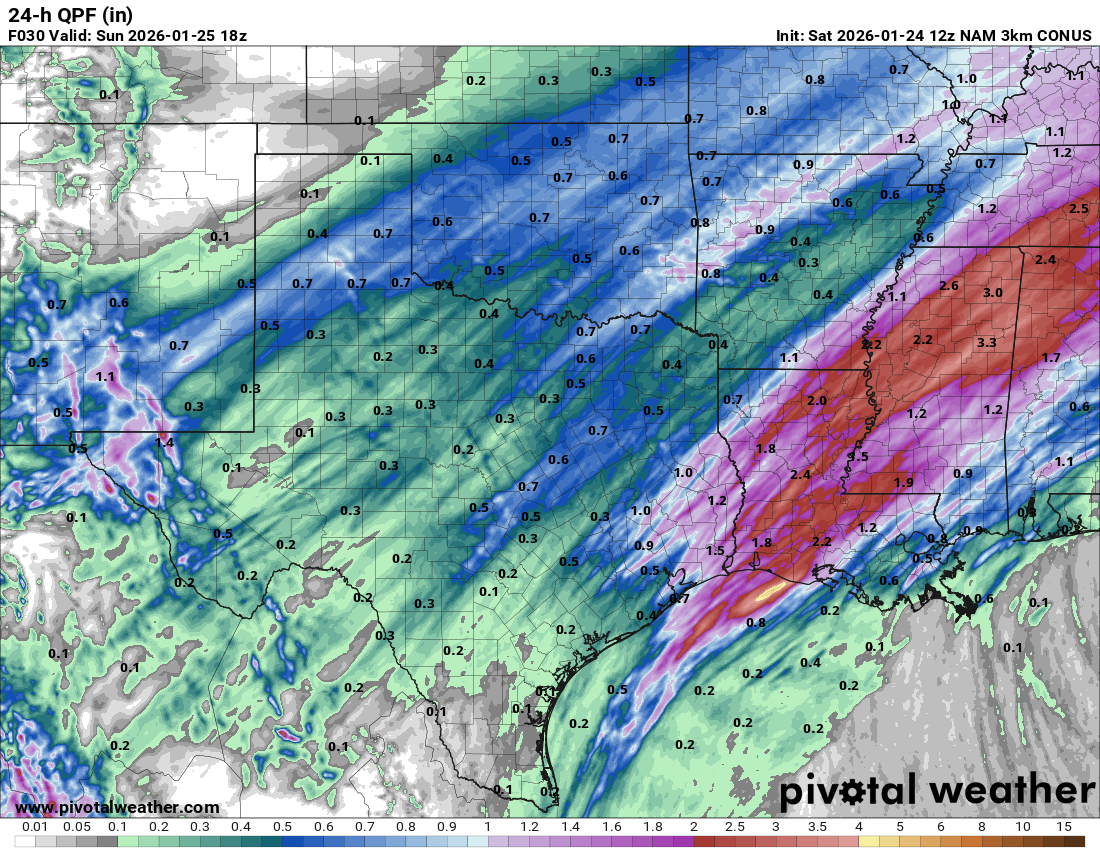
WRFs


HRRR

ETA: Wow, Oklahoma did bust big time on QPF with round 1
Last edited by
bubba hotep on Sat Jan 24, 2026 11:34 am, edited 1 time in total.
3 likes
Winter time post are almost exclusively focused on the DFW area.
-
Cpv17
- Category 5
- Posts: 5170
- Joined: Wed Dec 07, 2016 2:24 pm
- Location: Wharton/El Campo, TX
#4771 Postby Cpv17 » Sat Jan 24, 2026 11:22 am
Brazoria979cnty wrote:Cpv17 wrote:txtwister78 wrote:I will say this pattern is loaded for the month of February if you like more winter weather.
Yes, but I’m seeing a lot of maps on X that have the majority of the cold going towards the EC over the next few weeks. Hoping that’s wrong.
I will say though from what I saw the EPS looked significantly better for the central U.S. compared to the GEFS for mid February.
That would be our luck
The goal for me is always snow. You don’t always need the coldest anomalies to go directly towards you for that to happen anyway. So I’m hopeful. Like Ntxw said, the teleconnections overall look solid. Would like a bit of a SE ridge though, not gonna lie lol
0 likes
-
Ntxw
- Storm2k Moderator
- Posts: 23361
- Joined: Wed Oct 21, 2009 6:34 pm
- Location: DFW, Texas
#4772 Postby Ntxw » Sat Jan 24, 2026 11:23 am
I don't know how wxman57 is doing but this 20F feels hot after being in it for so long. I know Stratton would agree.
3 likes
The above post and any post by Ntxw is NOT an official forecast and should not be used as such. It is just the opinion of the poster and may or may not be backed by sound meteorological data. It is NOT endorsed by any professional institution including Storm2k. For official information, please refer to NWS products.
Help support Storm2K!
-
snownado
- Category 5
- Posts: 1046
- Joined: Sat Dec 09, 2023 7:00 pm
- Location: Plano, TX
#4773 Postby snownado » Sat Jan 24, 2026 11:24 am
So TIL you can place weather forecast bets on Polymarket.
Definitely something I will keep in mind for the future...

4 likes
-
orangeblood
- S2K Supporter
- Posts: 3855
- Joined: Tue Dec 15, 2009 6:14 pm
- Location: Fort Worth, TX
#4774 Postby orangeblood » Sat Jan 24, 2026 11:24 am
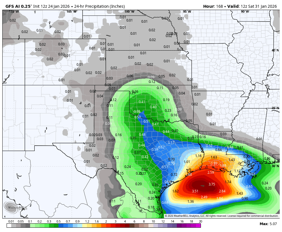
GFS AI staying very consistent with the next storm late week (plenty UL cold). It's Op is all over the place, very inconsistent
3 likes
-
TomballEd
- Category 5
- Posts: 1196
- Age: 62
- Joined: Wed Aug 16, 2023 4:52 pm
- Location: Spring/Klein area, not Tomball
#4775 Postby TomballEd » Sat Jan 24, 2026 11:29 am
0.64 inches of much appreciated cold rain at IAH, about 5 miles away. Down to 46F. HGX at my house adding up the 0.1 to 0.2 inches FZRA tonight and 0.1 to 0.3 tomorrow morning (forecast disco, they are following coldest guidance). 0.2 inches is enough to get surface streets quite dangerous. Max both periods totalling 0.5 inches would start affecting trees and powerlines. My gut looking at the mesos, especially the HRRR from 12Z (and a check on the 15Z) is that about a tenth of ice to as much as two tenths will fall on my yard. The Houston/Harris County advice of staying off the roads if possible is quite sound.
44F now at the airport. Down 2F in an hour.
I am nowhere near sold on next weekend. Not ruling it out but I need to see better agreement starting on the models. I also don't quite get the OUN area people complaining bust when they'' still probably approach a foot storm total. Unless Corpus Christi or Beaumont did much better I'd be 100% pleased with as little as 3 inches of snow, I guess because it is rare. A white lawn may not be 100% but I'm still pretty happy with any amount.
1 likes
-
rwfromkansas
- Category 5
- Posts: 2936
- Joined: Sat Aug 27, 2005 12:47 am
- Location: North Fort Worth
#4776 Postby rwfromkansas » Sat Jan 24, 2026 11:31 am
Seeing some Fort Worth slide offs on I-20 on social. Think it’s getting slicker.
2 likes
-
Cpv17
- Category 5
- Posts: 5170
- Joined: Wed Dec 07, 2016 2:24 pm
- Location: Wharton/El Campo, TX
#4777 Postby Cpv17 » Sat Jan 24, 2026 11:32 am
TomballEd wrote:0.64 inches of much appreciated cold rain at IAH, about 5 miles away. Down to 46F. HGX at my house adding up the 0.1 to 0.2 inches FZRA tonight and 0.1 to 0.3 tomorrow morning (forecast disco, they are following coldest guidance). 0.2 inches is enough to get surface streets quite dangerous. Max both periods totalling 0.5 inches would start affecting trees and powerlines. My gut looking at the mesos, especially the HRRR from 12Z (and a check on the 15Z) is that about a tenth of ice to as much as two tenths will fall on my yard. The Houston/Harris County advice of staying off the roads if possible is quite sound.
44F now at the airport. Down 2F in an hour.
I am nowhere near sold on next weekend. Not ruling it out but I need to see better agreement starting on the models. I also don't quite get the OUN area people complaining bust when they'' still probably approach a foot storm total. Unless Corpus Christi or Beaumont did much better I'd be 100% pleased with as little as 3 inches of snow, I guess because it is rare. A white lawn may not be 100% but I'm still pretty happy with any amount.
Next week needs to trend colder, IMO. At least for our area. Then I’d begin to feel more confident about it.
1 likes
-
TomballEd
- Category 5
- Posts: 1196
- Age: 62
- Joined: Wed Aug 16, 2023 4:52 pm
- Location: Spring/Klein area, not Tomball
#4778 Postby TomballEd » Sat Jan 24, 2026 11:32 am
Fifty Rock wrote:https://imgur.com/VVNYYS8
Nice. It took me a while to learn that. Open your imgur image in another tab and past that into image.

3 likes
-
BrokenGlass
- Tropical Storm
- Posts: 197
- Joined: Sun Jan 10, 2010 5:36 pm
- Location: Richardson, Texas
#4779 Postby BrokenGlass » Sat Jan 24, 2026 11:33 am
Getting some frizzle in Addison right now. Warming up my jeep for an adventure out.
Sent from my iPhone using Tapatalk Pro
3 likes
-
cheezyWXguy
- Category 5
- Posts: 6274
- Joined: Mon Feb 13, 2006 12:29 am
- Location: Dallas, TX
#4780 Postby cheezyWXguy » Sat Jan 24, 2026 11:44 am
BrokenGlass wrote:Getting some frizzle in Addison right now. Warming up my jeep for an adventure out.
Sent from my iPhone using Tapatalk Pro
Why drive if you don’t have to? Freezing drizzle sucks to drive in because the roads are fine until the moment they aren’t. Then we get videos like the one in fort worth before the main event in 2021
1 likes
Return to “Winter Weather”
Who is online
Users browsing this forum: bigddstranny, Brazoria979cnty, bubba hotep, cajungal, CaptinCrunch, cheezyWXguy, Cpv17, cstrunk, DonWrk, downsouthman1, Fifty Rock, foulbeast, gpsnowman, Haris, Harp.1, HockeyTx82, JayDT, jgh, kassi, LearnedHat, Longhornmaniac8, mmmmsnouts, Ntxw, opticsguy, Ralph's Weather, rmic, SnowintheFalls, South Texas Storms, Stonewood Ranch, Stratton23, Tammie, Texas Snow, Texas Snowman, texsn95, TomballEd, txtwister78 and 354 guests


