Winter Weather Discussion
Moderator: S2k Moderators
Forum rules
The posts in this forum are NOT official forecast and should not be used as such. They are just the opinion of the poster and may or may not be backed by sound meteorological data. They are NOT endorsed by any professional institution or
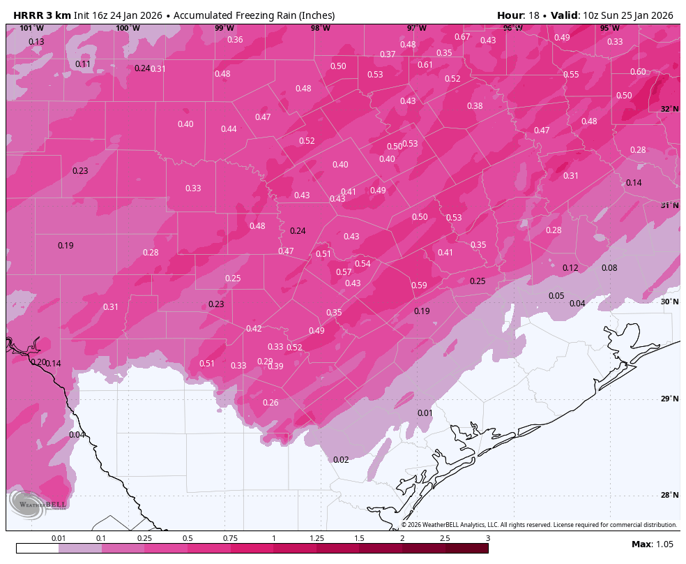
STORM2K.
-
Longhornmaniac8
- Category 1

- Posts: 258
- Joined: Thu Nov 18, 2010 2:30 am
- Location: Austin, TX
#4821 Postby Longhornmaniac8 » Sat Jan 24, 2026 1:29 pm
TomballEd wrote:HGX ice storm warning is greater than 0.25, below that is a WSW. That would be an ice storm down to San Antonio if that verifies. If I'm at EWX, I'd rather warn of an ice storm now for even greater public exposure, course of least regret. HRRR is doing better than the 3 km NAM, those amounts (power outage levels around Austin) would trigger me to pull the trigger rather than wait for the normal afternoon package.
Ask and you shall receive.
Ice Storm Warning for EWX.
4 likes
-
gpsnowman
- S2K Supporter

- Posts: 3324
- Joined: Fri Jan 07, 2011 10:35 am
- Location: Grand Prairie Tx
#4822 Postby gpsnowman » Sat Jan 24, 2026 1:31 pm
Although light, precip has picked up a bit. So light I can't tell what type it is.
Took a winter walk around the neighborhood with my daughter and we stopped in the woods to listen to a mini sleet shower. No cars, no planes, just the sound of sleet pellets hitting the trees and the ground. Cool moment, it's the little things.
8 likes
-
orangeblood
- S2K Supporter

- Posts: 3855
- Joined: Tue Dec 15, 2009 6:14 pm
- Location: Fort Worth, TX
#4823 Postby orangeblood » Sat Jan 24, 2026 1:33 pm
WacoWx wrote:Radar southwest of Dallas filling in nicely. Strong return entering Dallas proper rn
Lots of moisture and lift available between now and tomorrow morning, these sleet clusters will pop quickly
5 likes
-
Wthrfan
- Tropical Storm

- Posts: 158
- Joined: Thu Dec 22, 2022 10:49 am
- Location: Edmond,OK
#4824 Postby Wthrfan » Sat Jan 24, 2026 1:35 pm
Can you post video on here? Had a round come through with some silver dollar-sized flakes.
3 likes
-
Portastorm
- Storm2k Moderator

- Posts: 9946
- Age: 63
- Joined: Fri Jul 11, 2003 9:16 am
- Location: Round Rock, TX
-
Contact:
#4825 Postby Portastorm » Sat Jan 24, 2026 1:37 pm
Longhornmaniac8 wrote:TomballEd wrote:HGX ice storm warning is greater than 0.25, below that is a WSW. That would be an ice storm down to San Antonio if that verifies. If I'm at EWX, I'd rather warn of an ice storm now for even greater public exposure, course of least regret. HRRR is doing better than the 3 km NAM, those amounts (power outage levels around Austin) would trigger me to pull the trigger rather than wait for the normal afternoon package.
Ask and you shall receive.
Ice Storm Warning for EWX.
Yeah I posted about this coming at 11:56 am on this thread.

3 likes
Any forecasts under my name are to be taken with a grain of salt. Get your best forecasts from the National Weather Service and National Hurricane Center.
-
bigddstranny
- Tropical Low

- Posts: 29
- Joined: Sat Jan 30, 2010 3:55 am
- Location: Cedar Park, Tx
#4826 Postby bigddstranny » Sat Jan 24, 2026 1:38 pm
A few snow flakes intermittently. Temp down to 28. Standing water from the rain last night is starting to freeze.
3 likes
-
TomballEd
- Category 5

- Posts: 1197
- Age: 62
- Joined: Wed Aug 16, 2023 4:52 pm
- Location: Spring/Klein area, not Tomball
#4827 Postby TomballEd » Sat Jan 24, 2026 1:42 pm
Haris wrote:The latest HRRR right now is juiced up holy moly
Spots near and above half an inch of ice in Travis and Williamson Counties by 5 am with precip still falling is approaching catastrophe levels. If Austin area modelled too warm and there will be more sleet than ice, it just means power outage levels of ice will fall in the San Antonio area.

0 likes
-
jasons2k
- Storm2k Executive

- Posts: 8278
- Age: 52
- Joined: Wed Jul 06, 2005 12:32 pm
- Location: The Woodlands, TX
#4828 Postby jasons2k » Sat Jan 24, 2026 1:42 pm
Freeze line is roughly from Bastrop to Calvert to Palestine. Down to 39 here.
3 likes
-
rwfromkansas
- Category 5

- Posts: 2938
- Joined: Sat Aug 27, 2005 12:47 am
- Location: North Fort Worth
#4829 Postby rwfromkansas » Sat Jan 24, 2026 1:43 pm
Seeing some redevelopment again SW of FW. Good.
4 likes
-
Portastorm
- Storm2k Moderator

- Posts: 9946
- Age: 63
- Joined: Fri Jul 11, 2003 9:16 am
- Location: Round Rock, TX
-
Contact:
#4830 Postby Portastorm » Sat Jan 24, 2026 1:46 pm
TomballEd wrote:Haris wrote:The latest HRRR right now is juiced up holy moly
Spots near and above half an inch of ice in Travis and Williamson Counties by 5 am with precip still falling is approaching catastrophe levels. If Austin area modelled too warm and there will be more sleet than ice, it just means power outage levels of ice will fall in the San Antonio area.
https://i.imgur.com/zRNidmU.png
During the February 2023 ice storm we had .69" of freezing rain/ice and it was catastrophic in terms of tree loss and widespread power outages for days. In some areas, it was more than a week before power was restored. So yeah ... this latest development is very concerning!
4 likes
Any forecasts under my name are to be taken with a grain of salt. Get your best forecasts from the National Weather Service and National Hurricane Center.
-
orangeblood
- S2K Supporter

- Posts: 3855
- Joined: Tue Dec 15, 2009 6:14 pm
- Location: Fort Worth, TX
#4831 Postby orangeblood » Sat Jan 24, 2026 2:00 pm
.AVIATION...
(18Z TAFS)
Issued at 1135 AM CST Sat Jan 24 2026
No significant deviations to the previous TAF forecast for this
issuance. We`re in a relative lull in precipitation across the
region, although there are a few showers approaching the Metroplex
at this hour. This should mainly be -FZRA and -PL as there
continues to be a substantial warm nose above the surface. We`ll
maintain -FZRAPL through the afternoon, expecting that there will
be some periods where it`s dry.
Heavier intensity precipitation will start after dark and should
primarily be sleet. We`ll continue with moderate sleet from 02Z
through the overnight, however there is some concern that we could
see a quicker transition to snow if lift is stronger than
anticipated. If that occurs, then snow could be heavy at times.
For now, we`ll continue to monitor this and carry a snow/sleet mix
after 10Z with a transition to all snow by 14Z. Precipitation
should start to taper off around midday Sunday.
Dunn
&&
Latest from the FW NWS office, starting to mention the potential for heavy snow later tonight. Looking at the latest High Res, would imagine confidence is increasing and that office increasing totals across the area during the afternoon package
7 likes
-
mmmmsnouts
- Tropical Storm

- Posts: 208
- Joined: Tue Sep 05, 2023 10:04 pm
- Location: Arlington, TX
#4832 Postby mmmmsnouts » Sat Jan 24, 2026 2:01 pm
TomballEd wrote:Haris wrote:The latest HRRR right now is juiced up holy moly
Spots near and above half an inch of ice in Travis and Williamson Counties by 5 am with precip still falling is approaching catastrophe levels. If Austin area modelled too warm and there will be more sleet than ice, it just means power outage levels of ice will fall in the San Antonio area.
https://i.imgur.com/zRNidmU.png
Gotta say that model seems way off the mark if it’s forecasting almost half an inch of freezing rain in DFW. Last night was supposed to be the freezing rain phase up here and we barely got any, it was pretty much all sleet.
4 likes
-
HockeyTx82
- S2K Supporter

- Posts: 2736
- Joined: Tue Oct 27, 2009 11:17 am
- Location: Ponder, TX
#4833 Postby HockeyTx82 » Sat Jan 24, 2026 2:02 pm
It's been an adventurous day, very cold. Sleet does not feel pleasant hitting your face when you're out playing in it as it's coming down from the sky.
Also my phone died but my link is back live if anyone wants to check in on it, it should be up the rest of the night. I think my charger went bad.
https://www.youtube.com/live/X0hAvAyWKb ... Vu6qFo_jwd
0 likes
Don't hold me accountable for anything I post on this forum. Leave the real forecasting up to the professionals.
Location: Ponder, TX (all observation posts are this location unless otherwise noted)
-
Ntxw
- Storm2k Moderator

- Posts: 23363
- Joined: Wed Oct 21, 2009 6:34 pm
- Location: DFW, Texas
#4834 Postby Ntxw » Sat Jan 24, 2026 2:05 pm
Latest batch coming through the metroplex has re-paved everything in another coat of sleet.
5 likes
The above post and any post by Ntxw is NOT an official forecast and should not be used as such. It is just the opinion of the poster and may or may not be backed by sound meteorological data. It is NOT endorsed by any professional institution including Storm2k. For official information, please refer to NWS products.
Help support Storm2K!
-
jasons2k
- Storm2k Executive

- Posts: 8278
- Age: 52
- Joined: Wed Jul 06, 2005 12:32 pm
- Location: The Woodlands, TX
#4835 Postby jasons2k » Sat Jan 24, 2026 2:06 pm
Dropped to 38 at 1pm on the dot. Dropping at about 1 degree per hour.
1 likes
-
TomballEd
- Category 5

- Posts: 1197
- Age: 62
- Joined: Wed Aug 16, 2023 4:52 pm
- Location: Spring/Klein area, not Tomball
#4836 Postby TomballEd » Sat Jan 24, 2026 2:06 pm
Portastorm wrote:Longhornmaniac8 wrote:TomballEd wrote:
HGX ice storm warning is greater than 0.25, below that is a WSW. That would be an ice storm down to San Antonio if that verifies. If I'm at EWX, I'd rather warn of an ice storm now for even greater public exposure, course of least regret. HRRR is doing better than the 3 km NAM, those amounts (power outage levels around Austin) would trigger me to pull the trigger rather than wait for the normal afternoon package.
Ask and you shall receive.
Ice Storm Warning for EWX.
Yeah I posted about this coming at 11:56 am on this thread.

I go away an hour or two and there are three or four new pages. I mainly read for latest obs and models, so I go to second to last page and start from there. Nothing winter like, but we're getting a nice moderate shower. We've done a little better than the Hill Country, but we've been dry and I'm loving the rain.
1 likes
-
txtwister78
- Category 5

- Posts: 2090
- Joined: Wed Jan 30, 2019 12:56 pm
- Location: San Antonio
#4837 Postby txtwister78 » Sat Jan 24, 2026 2:07 pm
TomballEd wrote:Haris wrote:The latest HRRR right now is juiced up holy moly
Spots near and above half an inch of ice in Travis and Williamson Counties by 5 am with precip still falling is approaching catastrophe levels. If Austin area modelled too warm and there will be more sleet than ice, it just means power outage levels of ice will fall in the San Antonio area.
https://i.imgur.com/zRNidmU.png
Right call by NWS although I would've probably included Bexar considering such a large population center and with HRRR continuing to trend colder each hourly run as this continues to be a "catch up" type event down here as mentioned earlier. My guess is that ends up happening anyway but with a WSW already in place hopefully folks are as prepared as can be.
3 likes
-
bubba hotep
- S2K Supporter

- Posts: 5956
- Joined: Wed Dec 28, 2016 1:00 am
- Location: Collin County Texas
#4838 Postby bubba hotep » Sat Jan 24, 2026 2:13 pm
Ntxw wrote:Latest batch coming through the metroplex has re-paved everything in another coat of sleet.
A few snow flakes mixing here in Collin County.
3 likes
Winter time post are almost exclusively focused on the DFW area.
-
gpsnowman
- S2K Supporter

- Posts: 3324
- Joined: Fri Jan 07, 2011 10:35 am
- Location: Grand Prairie Tx
#4839 Postby gpsnowman » Sat Jan 24, 2026 2:17 pm
bubba hotep wrote:Ntxw wrote:Latest batch coming through the metroplex has re-paved everything in another coat of sleet.
A few snow flakes mixing here in Collin County.
Excellent. Signs of an earlier transition? Still a wind driven microscopic winter mix down here.
Last edited by
gpsnowman on Sat Jan 24, 2026 2:17 pm, edited 1 time in total.
2 likes
-
TomballEd
- Category 5

- Posts: 1197
- Age: 62
- Joined: Wed Aug 16, 2023 4:52 pm
- Location: Spring/Klein area, not Tomball
#4840 Postby TomballEd » Sat Jan 24, 2026 2:17 pm
18Z HRRR is still a bit behind the trends. It still shows icing near DFW and I suspect that should be all snow and all sleet. Or my mention of the heaviest icing probably being a county or three too far N still seems quite plausible. If SAT misses a major ice storm it looks to be more about heavier precip being N of I-10 than where the freeze line gets.
1 likes
Return to “Winter Weather”
Who is online
Users browsing this forum: acinonyx, Bobbyh83, Brent, bubba hotep, cajungal, Captmorg70, cheezyWXguy, chickypez, Coldandsnow, downsouthman1, GeauxTigers, Golfisnoteasy75, gpsnowman, Haddox12, Harp.1, iorange55, JayDT, jg5894, Longhornmaniac8, Marion Morrison, mmmmsnouts, Ntxw, opticsguy, rendihess, rwfromkansas, rylo7956, sensoria, Stonewood Ranch, Stratton23, Texas Snowman, TomballEd, txtwister78, WeatherP1 and 353 guests