Good points by one of our resident mets above. One thing I would say however is that with the previous event, most models 5 days out or so began to lose the big cold and teleconnections really weren't exactly screaming major cold either (weakish negative EPO signal), not to mention our friend the positive PNA so as it looks today, there seems to be a little more of a "favorable" signal for cold with some of those factors looking a bit more in play/bullish to me including the PNA reversal.
But as our warm traveler points out above, a lot can change between now and then so definitely going to need more consistency and data over the coming days before we can even begin to discern what type of pattern this evolves into, but this one looks different to me right now.
Texas Winter 2024-2025
Moderator: S2k Moderators
Forum rules
 The posts in this forum are NOT official forecast and should not be used as such. They are just the opinion of the poster and may or may not be backed by sound meteorological data. They are NOT endorsed by any professional institution or STORM2K.

The posts in this forum are NOT official forecast and should not be used as such. They are just the opinion of the poster and may or may not be backed by sound meteorological data. They are NOT endorsed by any professional institution or STORM2K.
-
txtwister78

- Category 5

- Posts: 2152
- Joined: Wed Jan 30, 2019 12:56 pm
- Location: San Antonio
Re: Texas Winter 2024-2025
2 likes


Re: Texas Winter 2024-2025
bubba hotep wrote:Ntxw wrote:12z euro is cold for the mentioned period. Snow along the frontal boundary and then.
Pushing single digits for DFW
Let’s get that LES going on area lakes. AO and NAO for now look to go positive so my guess is the next big shot will have SE ridge at play.
5 likes
The above post and any post by Ntxw is NOT an official forecast and should not be used as such. It is just the opinion of the poster and may or may not be backed by sound meteorological data. It is NOT endorsed by any professional institution including Storm2k. For official information, please refer to NWS products.
Help support Storm2K!
-
Stratton23
- Category 5
- Posts: 3505
- Joined: Fri Jul 21, 2023 10:59 pm
- Location: Katy, Tx
Re: Texas Winter 2024-2025
12z ensembles are in, starting to see barney colors showing up on the EPS and GEPS, barney colors on an operational are crazy enough, but when an ensemble starts showing them, oh boy!
8 likes
Re: Texas Winter 2024-2025
bubba hotep wrote:Ntxw wrote:12z euro is cold for the mentioned period. Snow along the frontal boundary and then
Pushing single digits for DFW
Here comes Barney!!
5 likes
-
Iceresistance

- Category 5
- Posts: 9572
- Age: 22
- Joined: Sat Oct 10, 2020 9:45 am
- Location: Tecumseh, OK/Norman, OK
Re: Texas Winter 2024-2025
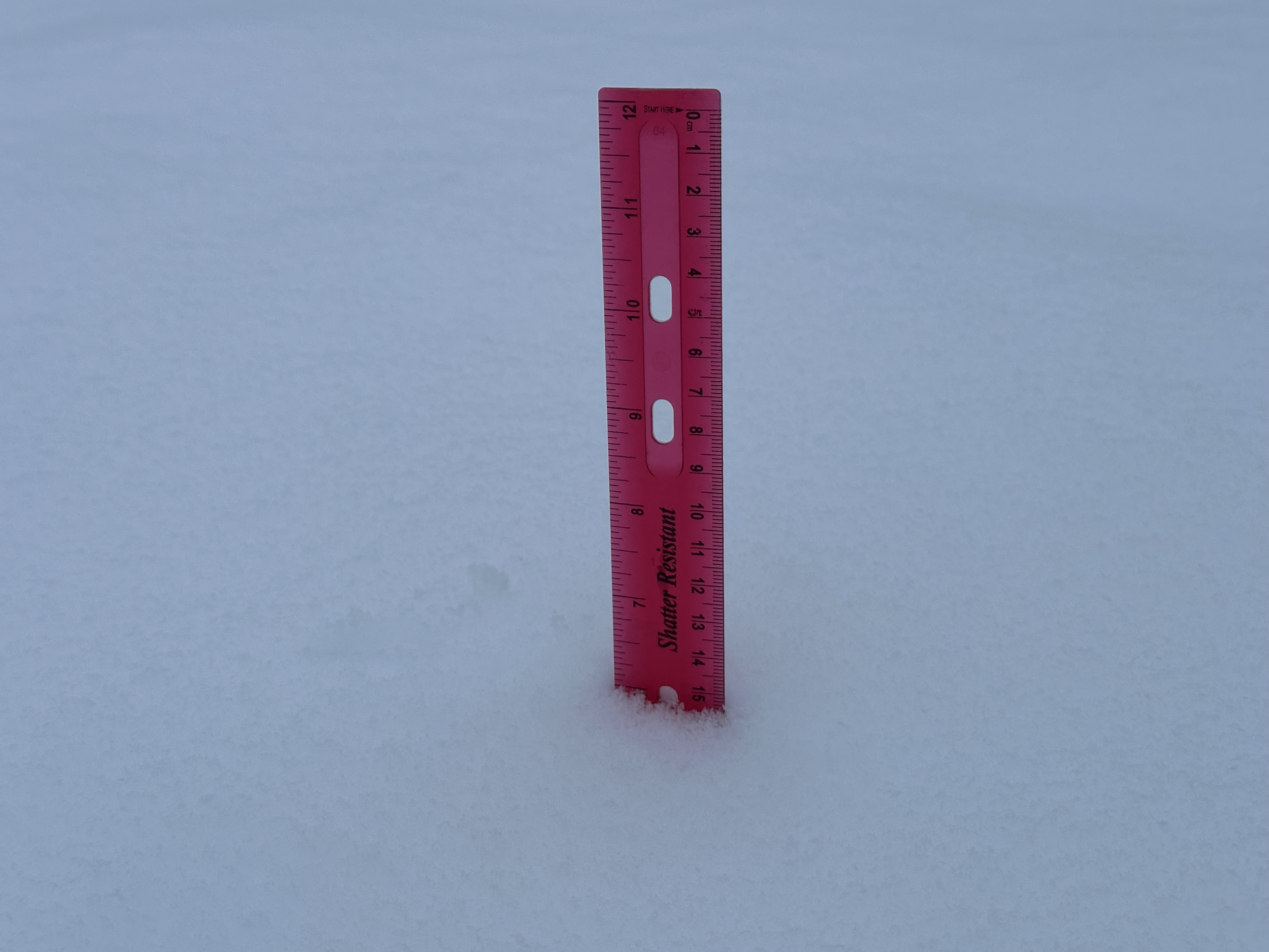
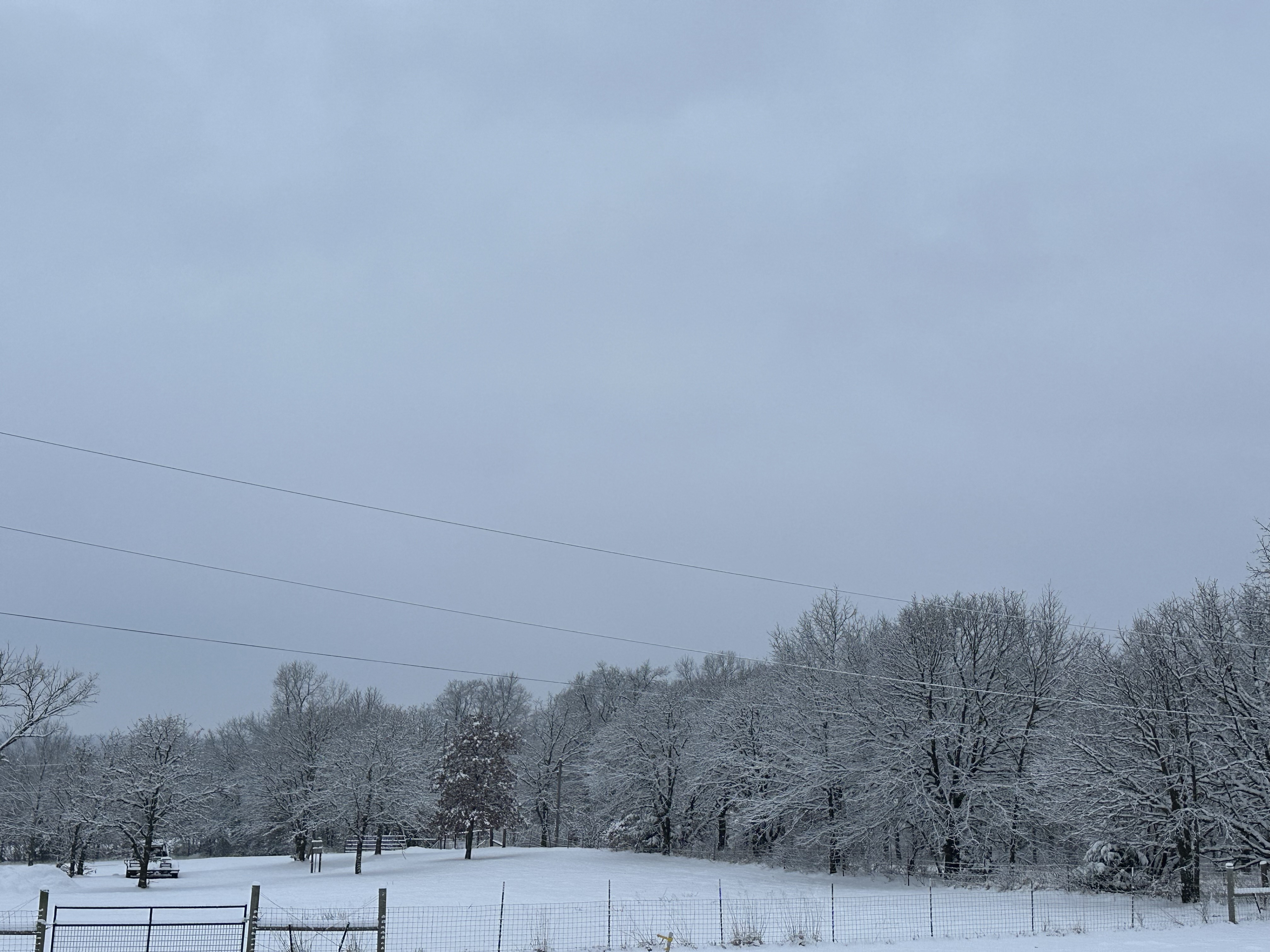
The final measurement is 6 inches of snow, as seen with the ruler. The snow ended at around 9:30 AM. This is more snow than all of last winter
https://s7.gifyu.com/images/SX5OY.jpg
https://s13.gifyu.com/images/SX5Of.jpg
https://s7.gifyu.com/images/SX5OY.jpg
https://s13.gifyu.com/images/SX5Of.jpg
7 likes
Bill 2015 & Beta 2020
Winter 2020-2021
All observations are in Tecumseh, OK unless otherwise noted.
Winter posts are focused mainly for Oklahoma & Texas.
Take any of my forecasts with a grain of salt, refer to the NWS, SPC, and NHC for official information
Never say Never with weather! Because ANYTHING is possible!
Winter 2020-2021
All observations are in Tecumseh, OK unless otherwise noted.
Winter posts are focused mainly for Oklahoma & Texas.
Take any of my forecasts with a grain of salt, refer to the NWS, SPC, and NHC for official information
Never say Never with weather! Because ANYTHING is possible!
-
Golfisnteasy7575
- Tropical Storm

- Posts: 156
- Joined: Sun Oct 13, 2024 7:25 pm
Re: Texas Winter 2024-2025
We got between 5-6 here in jackson so far with a little more left. Not bad. I'm happy we didn't get shut out
4 likes
-
orangeblood
- S2K Supporter

- Posts: 3895
- Joined: Tue Dec 15, 2009 6:14 pm
- Location: Fort Worth, TX
Re: Texas Winter 2024-2025
gpsnowman wrote:bubba hotep wrote:Ntxw wrote:12z euro is cold for the mentioned period. Snow along the frontal boundary and then
Pushing single digits for DFW
Here comes Barney!!
and I may add it's a "MEAN" Barney inside 10 days


7 likes
-
Iceresistance
- Category 5
- Posts: 9572
- Age: 22
- Joined: Sat Oct 10, 2020 9:45 am
- Location: Tecumseh, OK/Norman, OK
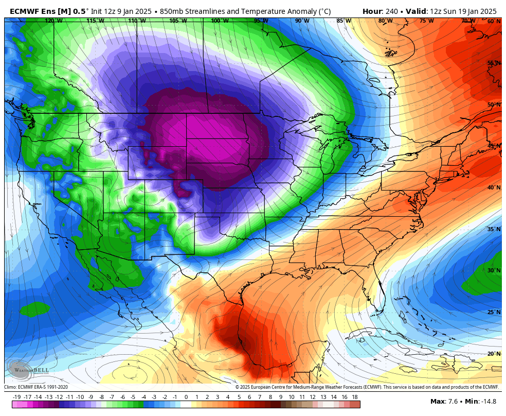
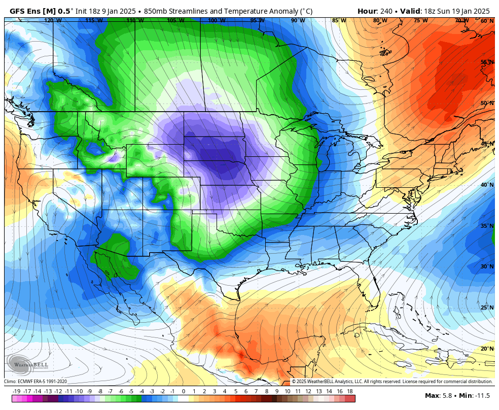
Re: Texas Winter 2024-2025
orangeblood wrote:gpsnowman wrote:bubba hotep wrote:
Pushing single digits for DFW
Here comes Barney!!
and I may add it's a "MEAN" Barney inside 10 days
https://images.weatherbell.com/model/ecmwf-ensemble-avg/conus/t850_anom_stream/1736510400/1737352800-tW5QrzkQe0Y.png
And the trend? Holy moly
https://s7.gifyu.com/images/SX5Ow.gif
5 likes
Bill 2015 & Beta 2020
Winter 2020-2021
All observations are in Tecumseh, OK unless otherwise noted.
Winter posts are focused mainly for Oklahoma & Texas.
Take any of my forecasts with a grain of salt, refer to the NWS, SPC, and NHC for official information
Never say Never with weather! Because ANYTHING is possible!
Winter 2020-2021
All observations are in Tecumseh, OK unless otherwise noted.
Winter posts are focused mainly for Oklahoma & Texas.
Take any of my forecasts with a grain of salt, refer to the NWS, SPC, and NHC for official information
Never say Never with weather! Because ANYTHING is possible!
-
CaptinCrunch

- S2K Supporter
- Posts: 8776
- Age: 58
- Joined: Mon Nov 03, 2003 4:33 pm
- Location: Kennedale, TX (Tarrant Co.)
Re: Texas Winter 2024-2025
Steve McCauley
The last of the snow flurries is fading away during the lunch hour, but the winter storm has left its mark on about half of the region. Snowfall totals ranged from 1 to 11 inches across north Texas with the BIG winner on the NW side of Sherman where nearly a foot of snow fell. MyOwnRadar detected lightning strikes in the area, so it is possible this was a thundersnow event.
As you can see from this graphic, the line that was predicted to separate the Snow / No Snow area was off by about an average of 25 miles. But for those who visit this page often were probably not suprised.
You will recall that the text of the forecast from 2 days ago stated the following:
"Keep this in mind: if the forecast temperature is off by as little as 1 degree, this will have a MAJOR impact on the predicted amounts of each precipitation type. "
And sure enough, the weather balloon data from last night revealed I was off by 1.5 degrees at the 5000-feet-above-ground level, which caused the falling snowflakes to mostly melt just before hitting the ground south of the Snow-No Snow line. Had the forecast been 1.5 degrees more accurate at the 5000-foot level, the snow line would have matched up well with the prediction.
Normally, no one notices when we are off by only 1.5 degrees. But this was a HUGE mistake if you are in that narrow band! But, of course, we mostly only hear from the folks in that 25 to 30 mile band that think the winter storm missed everyone, and that the forecast was a complete bust.
For you folks with at least a couple of inches of snow on the ground, your low temperature tonight may fall into the teens while the southern half of the region will fall into the 20s. This means any residual moisture will freeze solid, so take extra precuations as you head out the door Saturday morning!
NOTE: Some of these totals may be understated since some melting has occurred in the last 24 hours.
2 likes

-
orangeblood
- S2K Supporter
- Posts: 3895
- Joined: Tue Dec 15, 2009 6:14 pm
- Location: Fort Worth, TX
Re: Texas Winter 2024-2025
CaptinCrunch wrote:Steve McCauley
The last of the snow flurries is fading away during the lunch hour, but the winter storm has left its mark on about half of the region. Snowfall totals ranged from 1 to 11 inches across north Texas with the BIG winner on the NW side of Sherman where nearly a foot of snow fell. MyOwnRadar detected lightning strikes in the area, so it is possible this was a thundersnow event.
As you can see from this graphic, the line that was predicted to separate the Snow / No Snow area was off by about an average of 25 miles. But for those who visit this page often were probably not suprised.
You will recall that the text of the forecast from 2 days ago stated the following:
"Keep this in mind: if the forecast temperature is off by as little as 1 degree, this will have a MAJOR impact on the predicted amounts of each precipitation type. "
And sure enough, the weather balloon data from last night revealed I was off by 1.5 degrees at the 5000-feet-above-ground level, which caused the falling snowflakes to mostly melt just before hitting the ground south of the Snow-No Snow line. Had the forecast been 1.5 degrees more accurate at the 5000-foot level, the snow line would have matched up well with the prediction.
Normally, no one notices when we are off by only 1.5 degrees. But this was a HUGE mistake if you are in that narrow band! But, of course, we mostly only hear from the folks in that 25 to 30 mile band that think the winter storm missed everyone, and that the forecast was a complete bust.
For you folks with at least a couple of inches of snow on the ground, your low temperature tonight may fall into the teens while the southern half of the region will fall into the 20s. This means any residual moisture will freeze solid, so take extra precuations as you head out the door Saturday morning!
NOTE: Some of these totals may be understated since some melting has occurred in the last 24 hours.
Great post by McCauley...Atlanta was the mirror image of DFW, went 1.5 Deg the other way and they are covered in a 6" plus blanket of white.
3 likes
-
South Texas Storms

- Professional-Met

- Posts: 4256
- Joined: Thu Jun 24, 2010 12:28 am
- Location: Houston, TX
Re: Texas Winter 2024-2025
Confidence is increasing that the coldest air of the winter will be arriving between January 19-26. Still too early to tell if frozen precip will accompany this cold blast, but this could definitely cause ERCOT some issues. Sure hope we can get through this next cold blast without any rolling outages. I highly doubt we'll see anything extremely cold this winter after this next wave.
6 likes
Re: Texas Winter 2024-2025
South Texas Storms wrote:Confidence is increasing that the coldest air of the winter will be arriving between January 19-26. Still too early to tell if frozen precip will accompany this cold blast, but this could definitely cause ERCOT some issues. Sure hope we can get through this next cold blast without any rolling outages. I highly doubt we'll see anything extremely cold this winter after this next wave.
Looks like many parts of Texas will potentially have a below normal month. What's that?
5 likes
-
orangeblood
- S2K Supporter
- Posts: 3895
- Joined: Tue Dec 15, 2009 6:14 pm
- Location: Fort Worth, TX
Re: Texas Winter 2024-2025
South Texas Storms wrote:Confidence is increasing that the coldest air of the winter will be arriving between January 19-26. Still too early to tell if frozen precip will accompany this cold blast, but this could definitely cause ERCOT some issues. Sure hope we can get through this next cold blast without any rolling outages. I highly doubt we'll see anything extremely cold this winter after this next wave.
Yeah, this one looks like the real deal...similar signs you see with the Big Southern Plains Outbreaks.
4 likes
-
Iceresistance
- Category 5
- Posts: 9572
- Age: 22
- Joined: Sat Oct 10, 2020 9:45 am
- Location: Tecumseh, OK/Norman, OK
Re: Texas Winter 2024-2025
GEFS also has a major uptrend with the upcoming cold, no wonder why the CPC noticed the possibility of very cold and very snowy conditions in a couple of weeks
https://s7.gifyu.com/images/SX5Gl.gif
https://s7.gifyu.com/images/SX5Gl.gif
4 likes
Bill 2015 & Beta 2020
Winter 2020-2021
All observations are in Tecumseh, OK unless otherwise noted.
Winter posts are focused mainly for Oklahoma & Texas.
Take any of my forecasts with a grain of salt, refer to the NWS, SPC, and NHC for official information
Never say Never with weather! Because ANYTHING is possible!
Winter 2020-2021
All observations are in Tecumseh, OK unless otherwise noted.
Winter posts are focused mainly for Oklahoma & Texas.
Take any of my forecasts with a grain of salt, refer to the NWS, SPC, and NHC for official information
Never say Never with weather! Because ANYTHING is possible!
-
txtwister78
- Category 5
- Posts: 2152
- Joined: Wed Jan 30, 2019 12:56 pm
- Location: San Antonio
Re: Texas Winter 2024-2025
CaptinCrunch wrote:Steve McCauley
The last of the snow flurries is fading away during the lunch hour, but the winter storm has left its mark on about half of the region. Snowfall totals ranged from 1 to 11 inches across north Texas with the BIG winner on the NW side of Sherman where nearly a foot of snow fell. MyOwnRadar detected lightning strikes in the area, so it is possible this was a thundersnow event.
As you can see from this graphic, the line that was predicted to separate the Snow / No Snow area was off by about an average of 25 miles. But for those who visit this page often were probably not suprised.
You will recall that the text of the forecast from 2 days ago stated the following:
"Keep this in mind: if the forecast temperature is off by as little as 1 degree, this will have a MAJOR impact on the predicted amounts of each precipitation type. "
And sure enough, the weather balloon data from last night revealed I was off by 1.5 degrees at the 5000-feet-above-ground level, which caused the falling snowflakes to mostly melt just before hitting the ground south of the Snow-No Snow line. Had the forecast been 1.5 degrees more accurate at the 5000-foot level, the snow line would have matched up well with the prediction.
Normally, no one notices when we are off by only 1.5 degrees. But this was a HUGE mistake if you are in that narrow band! But, of course, we mostly only hear from the folks in that 25 to 30 mile band that think the winter storm missed everyone, and that the forecast was a complete bust.
For you folks with at least a couple of inches of snow on the ground, your low temperature tonight may fall into the teens while the southern half of the region will fall into the 20s. This means any residual moisture will freeze solid, so take extra precuations as you head out the door Saturday morning!
NOTE: Some of these totals may be understated since some melting has occurred in the last 24 hours.
Yeah good summary post event, but this was essentially the point I was trying to make on here leading up to the event in that setups like these (upper level driven) are complex down here further south for these reasons and model "bust" are quite common because all you have to be is off by those temps margins he mentions upstairs and the model that seemed locked in for days with heavier snow/sleet amounts all of a sudden is off by several inches (in cases like Euro a bunch). It was truly a battlezone of precip types throughout the event across the DFW metro as precited but through it all, I thought the NWS did as good as you could possibly expect with those razor margins at play.
1 likes
-
Iceresistance
- Category 5
- Posts: 9572
- Age: 22
- Joined: Sat Oct 10, 2020 9:45 am
- Location: Tecumseh, OK/Norman, OK
Re: Texas Winter 2024-2025
I just found this image from another forum, the agreement is insane! (I don't know what "FourCastNetV2" is, maybe a new model or something?) 

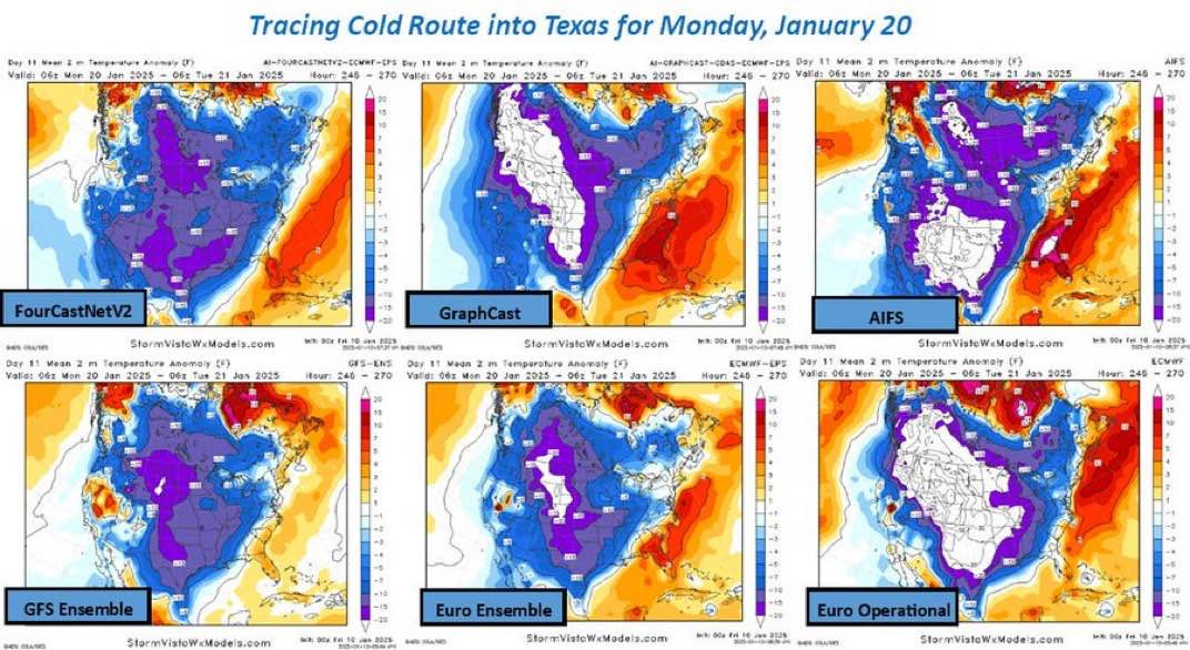
https://s13.gifyu.com/images/SX5GY.jpg
https://s13.gifyu.com/images/SX5GY.jpg
4 likes
Bill 2015 & Beta 2020
Winter 2020-2021
All observations are in Tecumseh, OK unless otherwise noted.
Winter posts are focused mainly for Oklahoma & Texas.
Take any of my forecasts with a grain of salt, refer to the NWS, SPC, and NHC for official information
Never say Never with weather! Because ANYTHING is possible!
Winter 2020-2021
All observations are in Tecumseh, OK unless otherwise noted.
Winter posts are focused mainly for Oklahoma & Texas.
Take any of my forecasts with a grain of salt, refer to the NWS, SPC, and NHC for official information
Never say Never with weather! Because ANYTHING is possible!
Re: Texas Winter 2024-2025
orangeblood wrote:CaptinCrunch wrote:Steve McCauley
The last of the snow flurries is fading away during the lunch hour, but the winter storm has left its mark on about half of the region. Snowfall totals ranged from 1 to 11 inches across north Texas with the BIG winner on the NW side of Sherman where nearly a foot of snow fell. MyOwnRadar detected lightning strikes in the area, so it is possible this was a thundersnow event.
As you can see from this graphic, the line that was predicted to separate the Snow / No Snow area was off by about an average of 25 miles. But for those who visit this page often were probably not suprised.
You will recall that the text of the forecast from 2 days ago stated the following:
"Keep this in mind: if the forecast temperature is off by as little as 1 degree, this will have a MAJOR impact on the predicted amounts of each precipitation type. "
And sure enough, the weather balloon data from last night revealed I was off by 1.5 degrees at the 5000-feet-above-ground level, which caused the falling snowflakes to mostly melt just before hitting the ground south of the Snow-No Snow line. Had the forecast been 1.5 degrees more accurate at the 5000-foot level, the snow line would have matched up well with the prediction.
Normally, no one notices when we are off by only 1.5 degrees. But this was a HUGE mistake if you are in that narrow band! But, of course, we mostly only hear from the folks in that 25 to 30 mile band that think the winter storm missed everyone, and that the forecast was a complete bust.
For you folks with at least a couple of inches of snow on the ground, your low temperature tonight may fall into the teens while the southern half of the region will fall into the 20s. This means any residual moisture will freeze solid, so take extra precuations as you head out the door Saturday morning!
NOTE: Some of these totals may be understated since some melting has occurred in the last 24 hours.
Great post by McCauley...Atlanta was the mirror image of DFW, went 1.5 Deg the other way and they are covered in a 6" plus blanket of white.
Not sure where you're getting that total for Atlanta from, but per the storm reports below, it was only a general 2-4".
https://www.fox5atlanta.com/news/atlant ... ce=twitter
You are correct though in that their snowfall was a lot "cleaner" than ours...
1 likes
-
txtwister78
- Category 5
- Posts: 2152
- Joined: Wed Jan 30, 2019 12:56 pm
- Location: San Antonio
Re: Texas Winter 2024-2025
Iceresistance wrote:I just found this image from another forum, the agreement is insane! (I don't know what "FourCastNetV2" is, maybe a new model or something?)
https://s13.gifyu.com/images/SX5GY.jpg
https://s13.gifyu.com/images/SX5GY.jpg
Yeah this will begin to get more attention early next week across all forums/media/social media should this signal continue. Right now focus is on the storm system that just exited our region.
1 likes

Re: Texas Winter 2024-2025
Harp.1 wrote:It’s south Louisiana’s turn, along with SE Texas!!!
Don’t leave me out of that lol 1/2 an inch of snow just isn’t enough lol
1 likes
Who is online
Users browsing this forum: No registered users and 98 guests