Deep South Winterwx Discussion 2015-2016
Moderator: S2k Moderators
Forum rules
 The posts in this forum are NOT official forecast and should not be used as such. They are just the opinion of the poster and may or may not be backed by sound meteorological data. They are NOT endorsed by any professional institution or STORM2K.

The posts in this forum are NOT official forecast and should not be used as such. They are just the opinion of the poster and may or may not be backed by sound meteorological data. They are NOT endorsed by any professional institution or STORM2K.
The radar is lighting up! Precip is developing at a fast rate.
0 likes
The posts in this forum are NOT official forecast and should not be used as such. They are just the opinion of the poster and may or may not be backed by sound meteorological data. They are NOT endorsed by any professional institution or storm2k.org. For official information, please refer to the NHC and NWS products.
-
northjaxpro

- S2K Supporter

- Posts: 8900
- Joined: Mon Sep 27, 2010 11:21 am
- Location: Jacksonville, FL
Re: Deep South Winterwx Discussion
CYCLONE MIKE wrote:Northjax, for us in se LA what do want to see happen with the shortwave in mexico tonight to get the most precip possible tomorrow?. Stay intact or shear apart? And obviously not dig any further south and speed up or hope it slows down?
Well, if the Baja shortwave stays intact and and is stronger than what was initialized, it is possble that it may catch up with the northern stream energy and start a phasing process. Should this happen, then we could be looking at a more pronounced development of a surface Low Pressure in the GOM later on Tuesday. The earlier model runs were anticipating the Baja shortwave to more likely eject ripples of energy in the southern stream and not anticipate any semblance of cyclogenesis until early Wednesday off the Georgia/ SC coast.
I stated back on Sunday that the Baja shortwave just may be more potent than forecast by the models had depicted. So, it will be interesting to see if how this shakes down in 24-36 hours.
0 likes
NEVER, EVER SAY NEVER in the tropics and weather in general, and most importantly, with life itself!!
________________________________________________________________________________________
Fay 2008 Beryl 2012 Debby 2012 Colin 2016 Hermine 2016 Julia 2016 Matthew 2016 Irma 2017 Dorian 2019
________________________________________________________________________________________
Fay 2008 Beryl 2012 Debby 2012 Colin 2016 Hermine 2016 Julia 2016 Matthew 2016 Irma 2017 Dorian 2019
Re: Deep South Winterwx Discussion
don't know if you guys know about this already but http://goo.gl/BawZzv you can use this to keep track of the temps and general observations and it refreshes every 15 minutes
0 likes
-
South Texas Storms

- Professional-Met

- Posts: 4258
- Joined: Thu Jun 24, 2010 12:28 am
- Location: Houston, TX
Re: Deep South Winterwx Discussion
How excited are y'all for this event? Too excited to sleep?
0 likes

Re: Deep South Winterwx Discussion
Another update from NO NWS:
AT 100 AM CST...FREEZE LINE WAS ROUGHLY FROM NEAR THE
LOUISIANA/MISSISSIPPI STATE LINE AT THE MISSISSIPPI RIVER TO
BROOKHAVEN AND MOVING SOUTH. TEMPERATURES HAVE FALLEN INTO THE MID
30S FROM A NEW ROADS TO MCCOMB LINE. WITH SLEET BEING REPORTED AT
KACP...OAKDALE IN CENTRAL LOUISIANA...PRECIPITATION RETURNS ACROSS
CENTRAL LOUISIANA ARE BEGINNING TO REACH THE GROUND. RADAR CONTINUES
TO INDICATE SLEET AND SNOW ALOFT OVER CENTRAL LOUISIANA INTO
SOUTHWEST MISSISSIPPI THAT WILL EVENTUALLY REACH THE GROUND AS
UPPER LEVEL MOISTURE CONTINUES TO INCREASE OVER THE REGION. RAIN
WAS ALSO DEVELOPING OVER WESTERN LOUISIANA SOUTH OF THE FREEZE
LINE AND WAS MOVING EAST AT 50 MPH.
0 likes
-
mcheer23

- Professional-Met
- Posts: 441
- Age: 32
- Joined: Sun Jun 24, 2012 8:24 pm
- Location: Sugar Land, Texas
Re: Deep South Winterwx Discussion
If I'm driving from Houston to Mobile,AL at 5am...Is that a safe drive? I should be in Mobile around noon
0 likes
Looks like 06z NAM wants to dissemble the shortwave. Back to hardly anything showing a pathetic .1-.15 QPF for BTR.
Not buying it. NAM been flip flopping back and forth. Agreed with 00z NAM.
Not buying it. NAM been flip flopping back and forth. Agreed with 00z NAM.
0 likes
The posts in this forum are NOT official forecast and should not be used as such. They are just the opinion of the poster and may or may not be backed by sound meteorological data. They are NOT endorsed by any professional institution or storm2k.org. For official information, please refer to the NHC and NWS products.
Re:
HurriGuy wrote:Looks like 06z NAM wants to dissemble the shortwave. Back to hardly anything showing a pathetic .1-.15 QPF for BTR.
Not buying it. NAM been flip flopping back and forth. Agreed with 00z NAM.
IDK if its true or not but i wonder if these in house models at TV stations run off some variations of the NAM because they've been flip flopping back and forth like that as well
0 likes
Re: Deep South Winterwx Discussion
mcheer23 wrote:If I'm driving from Houston to Mobile,AL at 5am...Is that a safe drive? I should be in Mobile around noon
That's a tough call. Be careful on those bridges especially. If you do make the trip, I hope you're not disappointed. That last NAM run looked pathetic.
Go Jags!
0 likes
-
Brent
- S2K Supporter
- Posts: 38749
- Age: 37
- Joined: Sun May 16, 2004 10:30 pm
- Location: Tulsa Oklahoma
- Contact:
Re: Deep South Winterwx Discussion
We seem to have a north shift up here... they just expanded the warning into the Atlanta metro:
THE NATIONAL WEATHER SERVICE IN PEACHTREE CITY HAS ISSUED A
WINTER STORM WARNING FOR LIGHT TO MODERATE SNOW...WHICH IS IN
EFFECT FROM 9 AM THIS MORNING TO 7 AM EST WEDNESDAY. THE WINTER
WEATHER ADVISORY IS NO LONGER IN EFFECT.
* LOCATIONS...ALL OF THE ATLANTA METRO AS WELL AS AREAS ALONG
INTERSTATE 20 WEST OF ATLANTA AND INTERSTATE 85 EAST OF ATLANTA.
* HAZARD TYPES...SNOW.
* ACCUMULATIONS...1 TO 2 INCHES.
0 likes
#neversummer


-
NewOrleans59
- Tropical Wave

- Posts: 6
- Joined: Mon Jan 27, 2014 10:26 pm
Re: Deep South Winterwx Discussion
First time poster, long time lurker.
Been reading a lot about this event on this board. I have a few questions about the low over the Baja.
Is that low expected to be the main player later this morning and today for the SE part of Louisiana and eastward? Is the precipitation currently showing up on radar an early onset of the entire system, or is the current precipitation the main and only energy to be expected, moving out before any precipitation could fall as frozen type in SELA, south of Lake Pontchartrain?
Thanks in advance!
0 likes

Re: Deep South Winterwx Discussion
06 GFS still giving BTR >.5 QPF.

Perhaps even more than last run.
Perhaps even more than last run.
Last edited by windnrain on Tue Jan 28, 2014 6:23 am, edited 1 time in total.
0 likes
-
NewOrleans59
- Tropical Wave
- Posts: 6
- Joined: Mon Jan 27, 2014 10:26 pm
Re:
windnrain wrote:GFS gives it ALL as ice though.
NWS inducates as much as 4-5 inches of smow at many airports later today in SELA.
Ice first, than snow. That would be bad correct?
0 likes
-
cycloneye

- Admin

- Posts: 149455
- Age: 69
- Joined: Thu Oct 10, 2002 10:54 am
- Location: San Juan, Puerto Rico
Re: Deep South Winterwx Discussion
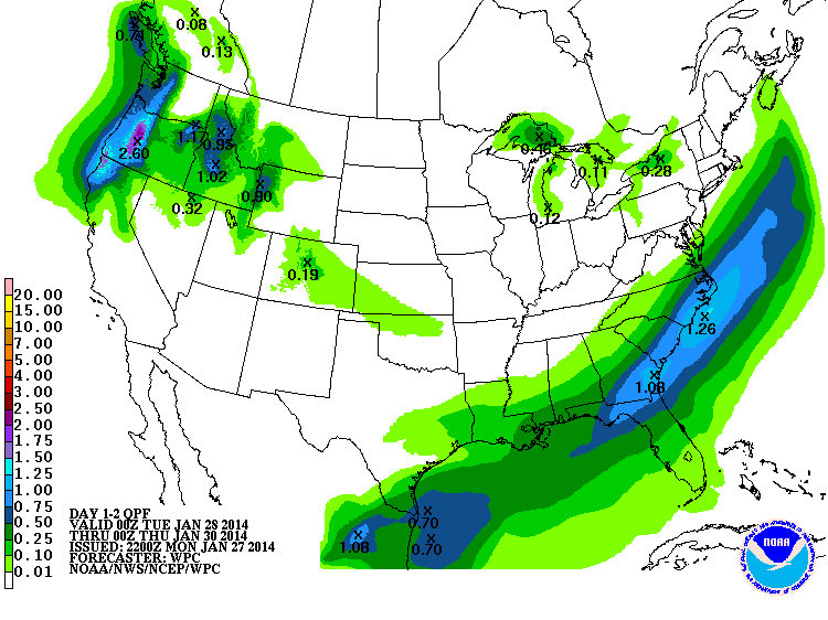
Latest WPC discussion.
QUANTITATIVE PRECIPITATION FORECAST DISCUSSION
NWS WEATHER PREDICTION CENTER COLLEGE PARK MD
454 AM EST TUE JAN 28 2014
FINAL DAY 1...DAY 2 AND DAY 3 QPF DISCUSSION
VALID JAN 28/1200 UTC THRU JAN 31/1200 UTC
REFERENCE AWIPS GRAPHICS UNDER...PRECIP ACCUM - 24HR
THE 06Z MODEL RUNS WERE IN VERY GOOD AGREEMENT WITH THE 00Z
RUNS..SO MADE ONLY VERY MINOR CHANGES
TO THE PRELIM DAY 1 QPF..MAINLY EARLY IN THE PERIOD AND BASED ON
RECENT RADAR IMAGERY/TRENDS.
DAY 1...
...GULF COAST/SOUTHEASTERN STATES UP INTO THE COASTAL MID
ATLANTIC/NEW ENGLAND AREAS...
THE LATEST MODEL RUNS HAVE COME INTO PRETTY GOOD AGREEMENT MASS
FIELD-WISE AND EVEN QPF-WISE CONCERNING THE WINTRY SYSTEM
IMPACTING MUCH OF THE GULF COAST/SOUTHEASTERN STATES REGION UP
INTO THE COASTAL MID ATLANTIC AND NEW ENGLAND AREAS THIS PERIOD.
SOME BACKING OF THE MID/UPPER LEVEL FLOW THRU THIS ENTIRE REGION
AHEAD OF THE PROGRESSIVE BUT SOMEWHAT DIGGING NORTHERN STREAM H5
S/WV..ALONG WITH MORE FAVORABLE LOW LEVEL GULF INFLOW INTO THE
GULF COAST AND SOUTHEASTERN STATES AND EVEN BETTER LOW LEVEL
ATLANTIC INFLOW INTO THE CAROLINAS..WILL SET THE STAGE FOR
SIGNIFICANT OVERRUNNING OF THE SHALLOW ARCTIC AIR IN PLACE AND
LEAD TO A WIDESPREAD WINTRY PRECIPITATION EVENT. AS MENTIONED
PREVIOUSLY..THE MODEL MASS FIELD FORECASTS OF THIS EVENT ARE NOW
IN VERY GOOD AGREEMENT..GIVING INCREASED CONFIDENCE NOT ONLY TO
THEIR SOLUTIONS BUT ALSO TO THE QPF. MANUAL QPF ENDED UP TAKING A
GENERAL BLEND OF VERY AGREEABLE GFS..ECMWF AND UKMET HIRES AND
CANADIAN GEM REGIONAL QPFS..WITH THE NAM LOOKING TO BE A BIT OF A
WET OUTLIER AT THIS POINT. SIGNIFICANT SNOWS AND POTENTIALLY
DANGEROUS ICE ACCUMULATIONS ARE EXPECTED WITH THIS EVENT..PLEASE
SEE THE QPFHSD FOR DETAILS ON THE WINTRY PRECIPITATION POTENTIAL.
0 likes
Visit the Caribbean-Central America Weather Thread where you can find at first post web cams,radars
and observations from Caribbean basin members Click Here
and observations from Caribbean basin members Click Here


Who is online
Users browsing this forum: No registered users and 42 guests