Texas Winter 2021-2022

Winter Weather Discussion

Moderator: S2k Moderators

Forum rules

The posts in this forum are NOT official forecast and should not be used as such. They are just the opinion of the poster and may or may not be backed by sound meteorological data. They are NOT endorsed by any professional institution or STORM2K.

Help Support Storm2K
Message
Author
User avatar
DFWLady
Tropical Depression
Tropical Depression
Posts: 55
Joined: Tue Dec 19, 2017 2:15 pm

Re: Texas Winter 2021-2022

#5021 Postby DFWLady » Wed Feb 02, 2022 8:29 pm

gboudx wrote:
DFWLady wrote:I'm sitting at 33 degrees and a steady heavy rain in Rockwall for about the last 2 hours! Waiting for my groceries outside Walmart and so far nothing but liquid! Here we go everyone! Cheers! :cold: :froze: :cold:

I’m in northern part of the county and it’s 32. 3 area PWSs show that temp. Plus my laser temp reader shows 31.

USA and Honduras are playing a World Cup qualifying match in St. Paul, MN. 5 degrees.


Well hello neighbor! I'm by downtown Rockwall! I'm about to head home from Walmart and am a little bit nervous about the bridge but think I'll be fine! Lots of people still out surprisingly!

Um no thank you lol that's WAY to cold to play anything in except with snow!
4 likes   

mcallum177
Tropical Depression
Tropical Depression
Posts: 98
Joined: Sun Jun 14, 2009 12:39 am
Location: Dallas, TX

Re: Texas Winter 2021-2022

#5022 Postby mcallum177 » Wed Feb 02, 2022 8:31 pm

Moderate rain and small icicles on our patio cover in Fate/Royse City.
4 likes   

Brent
S2K Supporter
S2K Supporter
Posts: 38094
Age: 37
Joined: Sun May 16, 2004 10:30 pm
Location: Tulsa Oklahoma
Contact:

Re: Texas Winter 2021-2022

#5023 Postby Brent » Wed Feb 02, 2022 8:33 pm

It's really just now starting to get good here. Could see some blowing snow a little. Also that wind chill bites :cold:

Image

Image

https://streamable.com/59d45q
9 likes   
#neversummer

User avatar
Ntxw
Storm2k Moderator
Storm2k Moderator
Posts: 22787
Joined: Wed Oct 21, 2009 6:34 pm
Location: DFW, Texas

Re: Texas Winter 2021-2022

#5024 Postby Ntxw » Wed Feb 02, 2022 8:36 pm

Image
3 likes   
The above post and any post by Ntxw is NOT an official forecast and should not be used as such. It is just the opinion of the poster and may or may not be backed by sound meteorological data. It is NOT endorsed by any professional institution including Storm2k. For official information, please refer to NWS products.

  Help support Storm2K!
Help Support Storm2K

User avatar
bubba hotep
S2K Supporter
S2K Supporter
Posts: 5837
Joined: Wed Dec 28, 2016 1:00 am
Location: Collin County Texas

Re: Texas Winter 2021-2022

#5025 Postby bubba hotep » Wed Feb 02, 2022 8:38 pm

jasons2k wrote:Mesoscale Discussion 0113
NWS Storm Prediction Center Norman OK
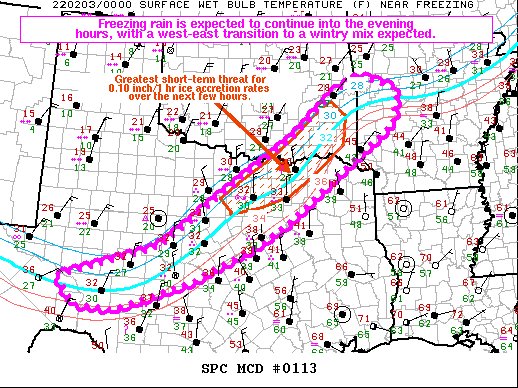
0711 PM CST Wed Feb 02 2022

Areas affected...portions of central into northern Texas...southeast
Oklahoma...western Arkansas

Concerning...Freezing rain

Valid 030111Z - 030515Z
SUMMARY...Freezing rain is ongoing across the region, and a few
instances of .10 inches/1 hour ice accretion rates are possible
going into the evening hours. The best chance for the heavier
freezing rain rates will be across northeast Texas into southwest
Arkansas.

DISCUSSION...Recent surface observations have noted accumulating
freezing rain across northern Texas over the past couple of hours.
Surface observations and 00Z mesoanalysis shows the surface freezing
line/web-bulb zero temperatures situated roughly from Crockett
County Texas, to areas just north of the DFW Metroplex, into the
Bryan-Le Flore County OK region. Surface-925 mb cold-air advection
is expected to gradually support the east-southeastward drift of
these near/below freezing surface temperatures with time, promoting
freezing rain (at least initially) across portions of southwest into
north-central TX, eastern OK, and western AR over the next 3-6 hours
(up to 06Z). MRMS mosaic radar imagery depicts up to 35-40 dBZ
values in close proximity to the surface freezing line in northern
Texas, which is overspread by above-freezing temperatures in the
925-700 mb layer per 00Z mesoanalysis. As such, occasionally heavier
freezing rain/ice accretion rates (perhaps up to 0.10 inch/1 hour)
may accompany heavier precipitation bands. However, deeper layers of
below-freezing temperatures are expected to usher into
central/northern TX and eastern OK through the evening, fostering a
more wintry mix (including sleet).

..Squitieri.. 02/03/2022

...Please see http://www.spc.noaa.gov for graphic product...

ATTN...WFO...LZK...SHV...TSA...FWD...OUN...SJT...MAF...


Image
5 likes   
Winter time post are almost exclusively focused on the DFW area.

BrokenGlassRepublicn
Category 1
Category 1
Posts: 481
Joined: Sun Nov 20, 2011 8:07 pm
Location: Richardson, Texas

Re: Texas Winter 2021-2022

#5026 Postby BrokenGlassRepublicn » Wed Feb 02, 2022 8:43 pm

The view from my son’s apartment in Columbia, MO a few hours ago…

Image


Sent from my iPhone using Tapatalk Pro
6 likes   

BrokenGlassRepublicn
Category 1
Category 1
Posts: 481
Joined: Sun Nov 20, 2011 8:07 pm
Location: Richardson, Texas

Re: Texas Winter 2021-2022

#5027 Postby BrokenGlassRepublicn » Wed Feb 02, 2022 8:45 pm

And a friend’s farm near Dumas…

Image


Sent from my iPhone using Tapatalk Pro
5 likes   

WacoWx
Category 2
Category 2
Posts: 664
Joined: Mon Dec 28, 2009 4:14 pm
Location: NOT Waco, TX ----> Dallas, TX

Re: Texas Winter 2021-2022

#5028 Postby WacoWx » Wed Feb 02, 2022 8:46 pm

Is the second round overnight going to be of equal strength as this first round in DFW?

This has had some impressive qpf
1 likes   

LearnedHat
Tropical Depression
Tropical Depression
Posts: 77
Joined: Wed Feb 10, 2010 11:17 am
Location: Keller, TX

Re: Texas Winter 2021-2022

#5029 Postby LearnedHat » Wed Feb 02, 2022 8:51 pm

It says I am in freezing rain but it is still raining in Keller - no sag on trees, icicles, etc.
0 likes   

User avatar
cheezyWXguy
Category 5
Category 5
Posts: 6108
Joined: Mon Feb 13, 2006 12:29 am
Location: Dallas, TX

Re: Texas Winter 2021-2022

#5030 Postby cheezyWXguy » Wed Feb 02, 2022 8:52 pm

My nearest station here in Dallas reporting 32 and a mix of rain and freezing rain. No glaze yet but that will probably change soon
1 likes   

User avatar
Ntxw
Storm2k Moderator
Storm2k Moderator
Posts: 22787
Joined: Wed Oct 21, 2009 6:34 pm
Location: DFW, Texas

Re: Texas Winter 2021-2022

#5031 Postby Ntxw » Wed Feb 02, 2022 8:53 pm

WacoWx wrote:Is the second round overnight going to be of equal strength as this first round in DFW?

This has had some impressive qpf


Yes if not pretty close. Modeled reflectivity dBZ is moderate at that time, with colder temperatures so more solid stuff falling then. 850s will be ~0c then vs 4-7C now.
1 likes   
The above post and any post by Ntxw is NOT an official forecast and should not be used as such. It is just the opinion of the poster and may or may not be backed by sound meteorological data. It is NOT endorsed by any professional institution including Storm2k. For official information, please refer to NWS products.


  Help support Storm2K!

Help Support Storm2K


Lagreeneyes03
Category 2
Category 2
Posts: 558
Joined: Mon Dec 09, 2013 10:53 am
Location: Luxurious Lake Grapevine

Re: Texas Winter 2021-2022

#5032 Postby Lagreeneyes03 » Wed Feb 02, 2022 8:57 pm

BrokenGlassRepublicn wrote:And a friend’s farm near Dumas…

https://uploads.tapatalk-cdn.com/20220203/45aea7d5ceca7b6c4eedeafb51954431.jpeg


Sent from my iPhone using Tapatalk Pro


That's beautiful, it looks so peaceful. You'd never be able to tell what year it was, just snow and a windmill in a field.
2 likes   
I'm a Princess, not a forecaster.

rwfromkansas
Category 5
Category 5
Posts: 2627
Joined: Sat Aug 27, 2005 12:47 am
Location: North Fort Worth

Re: Texas Winter 2021-2022

#5033 Postby rwfromkansas » Wed Feb 02, 2022 8:57 pm

Balloon info from FWD:

“The 00Z balloon didn`t make it all the way up, but did sample the
warm nose well and noted about a 3 degree drop in temperature
above the surface over the last couple of hours. Temps are still
about +3 to +5C above freezing around 850mb. This is expected to
persist for a few more hours while surface temperatures continue
to drop off to the northwest, supporting continued freezing rain.
We`ve seen ice accumulations around 1/10 of an inch so far along
the Red River and back to the west, mainly on trees and cars. As
surface temps fall further, some ice will begin to accumulate on
roads, particularly to the north and west. In the immediate
Metroplex and areas to the south, the strength of the warm nose
and the heavier precipitation falling through it have generally
helped keep surface temperatures at or a few degrees above
freezing.

The main trough is still back to the west, but large scale forcing
for ascent will increase markedly over the next few hours. This
lift will act to cool that warm nose, and we should see a
quick transition to sleet. Sleet accumulations could be rather
impressive through the overnight hours before we see a transition
over to snow during the early morning hours on Thursday.
Significant impacts to roads/travel are still expected across a
large portion of the region. Freezing rain and sleet will spread
southeast early Thursday with roads becoming ice covered. All of
the precipitation should end from west to east by late Thursday,
with temperatures falling into the teens areawide. Any ice/sleet/
snow accumulation on roads will linger into Friday before
temperatures slowly climb and we gradually clear.”
4 likes   

Yukon Cornelius
S2K Supporter
S2K Supporter
Posts: 1798
Age: 41
Joined: Thu Dec 20, 2012 9:23 pm
Location: Dean, TX/Westcliffe, CO

Re: Texas Winter 2021-2022

#5034 Postby Yukon Cornelius » Wed Feb 02, 2022 9:14 pm

Finally it’s changed to snow and it’s coming down heavy.
8 likes   
#neversummer

BrokenGlassRepublicn
Category 1
Category 1
Posts: 481
Joined: Sun Nov 20, 2011 8:07 pm
Location: Richardson, Texas

Re: Texas Winter 2021-2022

#5035 Postby BrokenGlassRepublicn » Wed Feb 02, 2022 9:17 pm

rwfromkansas wrote:Balloon info from FWD:

“The 00Z balloon didn`t make it all the way up, but did sample the
warm nose well and noted about a 3 degree drop in temperature
above the surface over the last couple of hours. Temps are still
about +3 to +5C above freezing around 850mb. This is expected to
persist for a few more hours while surface temperatures continue
to drop off to the northwest, supporting continued freezing rain.
We`ve seen ice accumulations around 1/10 of an inch so far along
the Red River and back to the west, mainly on trees and cars. As
surface temps fall further, some ice will begin to accumulate on
roads, particularly to the north and west. In the immediate
Metroplex and areas to the south, the strength of the warm nose
and the heavier precipitation falling through it have generally
helped keep surface temperatures at or a few degrees above
freezing.

The main trough is still back to the west, but large scale forcing
for ascent will increase markedly over the next few hours. This
lift will act to cool that warm nose, and we should see a
quick transition to sleet. Sleet accumulations could be rather
impressive through the overnight hours before we see a transition
over to snow during the early morning hours on Thursday.
Significant impacts to roads/travel are still expected across a
large portion of the region. Freezing rain and sleet will spread
southeast early Thursday with roads becoming ice covered. All of
the precipitation should end from west to east by late Thursday,
with temperatures falling into the teens areawide. Any ice/sleet/
snow accumulation on roads will linger into Friday before
temperatures slowly climb and we gradually clear.”

Kinda crazy to me that we're still launching balloons. Seems we could accomplish the same thing with drone technology, but what do I know.
2 likes   

User avatar
bubba hotep
S2K Supporter
S2K Supporter
Posts: 5837
Joined: Wed Dec 28, 2016 1:00 am
Location: Collin County Texas

Re: Texas Winter 2021-2022

#5036 Postby bubba hotep » Wed Feb 02, 2022 9:18 pm

Yukon Cornelius wrote:Finally it’s changed to snow and it’s coming down heavy.


Was coming to ask about that. Surface reports and limited upper air data indicate that the transition to sleet line should be moving into NW DFW. It looks like the transition to snow line is b/w Denton and the Falls.
2 likes   
Winter time post are almost exclusively focused on the DFW area.

User avatar
bubba hotep
S2K Supporter
S2K Supporter
Posts: 5837
Joined: Wed Dec 28, 2016 1:00 am
Location: Collin County Texas

Re: Texas Winter 2021-2022

#5037 Postby bubba hotep » Wed Feb 02, 2022 9:21 pm

Image
4 likes   
Winter time post are almost exclusively focused on the DFW area.

mcallum177
Tropical Depression
Tropical Depression
Posts: 98
Joined: Sun Jun 14, 2009 12:39 am
Location: Dallas, TX

Re: Texas Winter 2021-2022

#5038 Postby mcallum177 » Wed Feb 02, 2022 9:36 pm

I mean a balloon is probably significantly cheaper than a drone that can fly long enough to get to 40,000 feet.

BrokenGlassRepublicn wrote:
rwfromkansas wrote:Balloon info from FWD:

“The 00Z balloon didn`t make it all the way up, but did sample the
warm nose well and noted about a 3 degree drop in temperature
above the surface over the last couple of hours. Temps are still
about +3 to +5C above freezing around 850mb. This is expected to
persist for a few more hours while surface temperatures continue
to drop off to the northwest, supporting continued freezing rain.
We`ve seen ice accumulations around 1/10 of an inch so far along
the Red River and back to the west, mainly on trees and cars. As
surface temps fall further, some ice will begin to accumulate on
roads, particularly to the north and west. In the immediate
Metroplex and areas to the south, the strength of the warm nose
and the heavier precipitation falling through it have generally
helped keep surface temperatures at or a few degrees above
freezing.

The main trough is still back to the west, but large scale forcing
for ascent will increase markedly over the next few hours. This
lift will act to cool that warm nose, and we should see a
quick transition to sleet. Sleet accumulations could be rather
impressive through the overnight hours before we see a transition
over to snow during the early morning hours on Thursday.
Significant impacts to roads/travel are still expected across a
large portion of the region. Freezing rain and sleet will spread
southeast early Thursday with roads becoming ice covered. All of
the precipitation should end from west to east by late Thursday,
with temperatures falling into the teens areawide. Any ice/sleet/
snow accumulation on roads will linger into Friday before
temperatures slowly climb and we gradually clear.”

Kinda crazy to me that we're still launching balloons. Seems we could accomplish the same thing with drone technology, but what do I know.
2 likes   

rwfromkansas
Category 5
Category 5
Posts: 2627
Joined: Sat Aug 27, 2005 12:47 am
Location: North Fort Worth

Re: Texas Winter 2021-2022

#5039 Postby rwfromkansas » Wed Feb 02, 2022 9:42 pm

Definite pingers now much more common.
4 likes   

User avatar
bubba hotep
S2K Supporter
S2K Supporter
Posts: 5837
Joined: Wed Dec 28, 2016 1:00 am
Location: Collin County Texas

Re: Texas Winter 2021-2022

#5040 Postby bubba hotep » Wed Feb 02, 2022 9:44 pm

Freezing rain is getting old. Trees starting to sag, bushes bending, ornamental grass laying flat, I think that's enough.
3 likes   
Winter time post are almost exclusively focused on the DFW area.


Return to “Winter Weather”

Who is online

Users browsing this forum: No registered users and 3 guests