Texas Winter 2025-2026
Moderator: S2k Moderators
Forum rules
 The posts in this forum are NOT official forecast and should not be used as such. They are just the opinion of the poster and may or may not be backed by sound meteorological data. They are NOT endorsed by any professional institution or STORM2K.

The posts in this forum are NOT official forecast and should not be used as such. They are just the opinion of the poster and may or may not be backed by sound meteorological data. They are NOT endorsed by any professional institution or STORM2K.
-
GunnySgtGandalf
- Tropical Wave

- Posts: 3
- Joined: Tue Jan 21, 2025 1:50 pm
Re: Texas Winter 2025-2026
Heavy sleet in Georgetown and starting to pile up now. Thankfully freezing rain kept mostly at bay.
4 likes
-
rwfromkansas
- Category 5

- Posts: 3029
- Joined: Sat Aug 27, 2005 12:47 am
- Location: North Fort Worth
Re: Texas Winter 2025-2026
Fox 4 said ending around 7 a.m. for the heaviest, while CBS DFW said ending around 2 for the big stuff. That's a big difference. Hopefully, CBS is wrong. I think Fox 4 has a better reputation. Rarely even watch local news here.
Some in the central metro are still getting a bit of a dryslot, yuck.
Some in the central metro are still getting a bit of a dryslot, yuck.
1 likes
-
rwfromkansas
- Category 5
- Posts: 3029
- Joined: Sat Aug 27, 2005 12:47 am
- Location: North Fort Worth
Re: Texas Winter 2025-2026
The Azle area is the big winner tonight so far. Keep getting clobbered. I was confused for a bit...Runaway Bay is further northwest.
Last edited by rwfromkansas on Sat Jan 24, 2026 11:34 pm, edited 1 time in total.
1 likes
Re: Texas Winter 2025-2026
rwfromkansas wrote:Fox 4 said ending around 7 a.m. for the heaviest, while CBS DFW said ending around 2 for the big stuff. That's a big difference. Hopefully, CBS is wrong. I think Fox 4 has a better reputation. Rarely even watch local news here.
Some in the central metro are still getting a bit of a dryslot, yuck.
The stuff falling along I-35 is likely the biggest if anything else happens it will be a bonus. Guess we have to see where the ULL goes hopefully it pulls this way and we get some snow to end.
1 likes
-
cheezyWXguy

- Category 5
- Posts: 6282
- Joined: Mon Feb 13, 2006 12:29 am
- Location: Dallas, TX
Re: Texas Winter 2025-2026
Hopefully we can change over to snow by the time that surge out near midland gets here. Looks potent.
3 likes
-
Edwards Limestone

- S2K Supporter

- Posts: 510
- Age: 36
- Joined: Tue Dec 28, 2021 11:05 am
- Location: Smithson Valley, TX
Re: Texas Winter 2025-2026
Snowman67 wrote:JDawg512 wrote:I can also confirm thundersleet. Watching the lightning out my window.
Glad it's sleet and not freezing rain for you guys.
Oh there’s plenty of freezing rain further south where I am
(Canyon Lake area). I’m concerned about power outages overnight.
2 likes
The above post is NOT an official forecast and should not be used as such. It is just the opinion of the poster and may or may not be backed by sound meteorological data. It is NOT endorsed by any professional institution including Storm2k. For official information, please refer to NWS products.

Re: Texas Winter 2025-2026
7 likes
-
ThunderSleetDreams

- S2K Supporter
- Posts: 1510
- Age: 43
- Joined: Tue Dec 20, 2011 4:42 pm
- Location: S of Weimar, TX
Re: Texas Winter 2025-2026
iorange55 wrote:Heavy sleet and thunder in Austin!
Got some of it on video
https://streamable.com/0iqe9n
Sup boo!
3 likes
#NeverSummer
I hibernate when it gets above 75 degrees!
I hibernate when it gets above 75 degrees!

Re: Texas Winter 2025-2026
sensoria wrote:Thundersleet in South Austin!!!
If there is thunder, it is going to be intense sleet. Thundersleet is a rarity.
1 likes
-
jasons2k

- Storm2k Executive

- Posts: 8290
- Age: 52
- Joined: Wed Jul 06, 2005 12:32 pm
- Location: The Woodlands, TX
Re: Texas Winter 2025-2026
Mesoscale Discussion 0050
NWS Storm Prediction Center Norman OK
1052 PM CST Sat Jan 24 2026
Areas affected...portions of south-central/eastern Texas into western Louisiana
Concerning...Freezing rain
Valid 250452Z - 250845Z
SUMMARY...Mix of freezing rain and sleet likely overnight into early Sunday.
DISCUSSION...Freezing rain and occasional sleet has been ongoing from the San Antonio Metro to College Station, TX. There are reports of freezing rain accumulations around 0.05-0.10 of an inch in 3 hours. Guidance indicates that coverage of precipitation will increase over the next several hours across south-central Texas into western Louisiana as large scale ascent continues to increase.
Forecast RAP soundings depict a warm layer around 850 mb above more shallow sub-freezing air near the surface supporting the primary precipitation type to be freezing rain. HREF guidance indicates increasing probabilities of at least 0.05 of an inch per 3 hr freezing rainfall rates along and north of the I-10 corridor overnight into early Sunday morning. Sleet will remain possible at times in heavier bands, especially with further north extent into the deeper cold air across northeastern Texas.
..Thornton.. 01/25/2026
...Please see www.spc.noaa.gov for graphic product...
ATTN...WFO...LCH...SHV...HGX...FWD...EWX...SJT...
3 likes
-
downsouthman1
- Category 2

- Posts: 706
- Age: 46
- Joined: Fri Jan 07, 2011 8:14 pm
- Location: Rowlett, TX
Re: Texas Winter 2025-2026
Thundersleet in Rowlett!
2 likes
Not a professional MET! My posts are merely speculation.
-
txtwister78

- Category 5
- Posts: 2169
- Joined: Wed Jan 30, 2019 12:56 pm
- Location: San Antonio
Re: Texas Winter 2025-2026
CMC continues to signal another brutal surge of arctic air by Friday. GFS not as cold but nonetheless should keep us busy on the forum as we get passed this event.
7 likes
-
WacoWx
- Category 2
- Posts: 692
- Joined: Mon Dec 28, 2009 4:14 pm
- Location: NOT Waco, TX ----> Dallas, TX
Re: Texas Winter 2025-2026
Should Dallas be expecting the same moisture on the Midland radar to push through DFW overnight? I thought this current moisture was our main show?? It has not disappointed in the sleet dept.
1 likes
-
downsouthman1
- Category 2
- Posts: 706
- Age: 46
- Joined: Fri Jan 07, 2011 8:14 pm
- Location: Rowlett, TX
Re: Texas Winter 2025-2026
WacoWx wrote:Should Dallas be expecting the same moisture on the Midland radar to push through DFW overnight? I thought this current moisture was our main show?? It has not disappointed in the sleet dept.
It's a 2- fold main for some. 2 different features.
Last edited by downsouthman1 on Sun Jan 25, 2026 12:27 am, edited 1 time in total.
0 likes
Not a professional MET! My posts are merely speculation.
-
Edwards Limestone
- S2K Supporter
- Posts: 510
- Age: 36
- Joined: Tue Dec 28, 2021 11:05 am
- Location: Smithson Valley, TX
Re: Texas Winter 2025-2026
1 likes
The above post is NOT an official forecast and should not be used as such. It is just the opinion of the poster and may or may not be backed by sound meteorological data. It is NOT endorsed by any professional institution including Storm2k. For official information, please refer to NWS products.
Re: Texas Winter 2025-2026
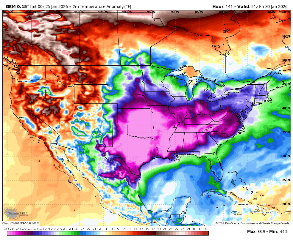
txtwister78 wrote:CMC continues to signal another brutal surge of arctic air by Friday. GFS not as cold but nonetheless should keep us busy on the forum as we get passed this event.
https://images.weatherbell.com/model/gem-all/conus/t2m_f_anom/1769299200/1769806800-68Ji3cE94js.png
It can keep the cold if it’s going to be dry. Hope we get a legit snowstorm in February to cap off the winter.
1 likes
-
downsouthman1
- Category 2
- Posts: 706
- Age: 46
- Joined: Fri Jan 07, 2011 8:14 pm
- Location: Rowlett, TX
Re: Texas Winter 2025-2026
The batch that moved away from El Paso & is currently near Fort Stockton should hit DFW later but the batch that is currently over El Paso i believe won't mane it here. Could be wrong though.
0 likes
Not a professional MET! My posts are merely speculation.
-
Edwards Limestone
- S2K Supporter
- Posts: 510
- Age: 36
- Joined: Tue Dec 28, 2021 11:05 am
- Location: Smithson Valley, TX
Re: Texas Winter 2025-2026
Surprised how quiet it is in here tonight.
3 likes
The above post is NOT an official forecast and should not be used as such. It is just the opinion of the poster and may or may not be backed by sound meteorological data. It is NOT endorsed by any professional institution including Storm2k. For official information, please refer to NWS products.
Who is online
Users browsing this forum: No registered users and 178 guests