Texas Winter 2013-2014
Moderator: S2k Moderators
Forum rules
 The posts in this forum are NOT official forecast and should not be used as such. They are just the opinion of the poster and may or may not be backed by sound meteorological data. They are NOT endorsed by any professional institution or STORM2K.

The posts in this forum are NOT official forecast and should not be used as such. They are just the opinion of the poster and may or may not be backed by sound meteorological data. They are NOT endorsed by any professional institution or STORM2K.


-
timmeister

- Tropical Storm

- Posts: 191
- Age: 63
- Joined: Thu Jan 06, 2011 11:17 am
- Location: Hattiesburg, MS
Re: Texas Winter 2013-2014
CMC-GDPS Sat 25 JAN 00Z

0 likes
Personal Forecast Disclaimer:
The posts in this forum are NOT official forecast and should not be used as such. They are just the opinion of the poster and may or may not be backed by sound meteorological data. They are NOT endorsed by any professional institution or storm2k.org. For official information, please refer to the NHC and NWS products.
The posts in this forum are NOT official forecast and should not be used as such. They are just the opinion of the poster and may or may not be backed by sound meteorological data. They are NOT endorsed by any professional institution or storm2k.org. For official information, please refer to the NHC and NWS products.
-
TeamPlayersBlue

- Category 5

- Posts: 3530
- Joined: Tue Feb 02, 2010 1:44 am
- Location: Denver/Applewood, CO
GFS trend looks good folks, lets seee what the euro does!
0 likes
Personal Forecast Disclaimer:
The posts in this forum are NOT official forecast and should not be used as such. They are just the opinion of the poster and may or may not be backed by sound meteorological data. They are NOT endorsed by any professional institution or storm2k.org. For official information, please refer to the NHC and NWS products.
The posts in this forum are NOT official forecast and should not be used as such. They are just the opinion of the poster and may or may not be backed by sound meteorological data. They are NOT endorsed by any professional institution or storm2k.org. For official information, please refer to the NHC and NWS products.

Re: Texas Winter 2013-2014
12Z GFS for DFW - 10 more days of BLAH.

But it gets interesting afterwards. Of course I believe the GFS > 5 days.


But it gets interesting afterwards. Of course I believe the GFS > 5 days.

0 likes
The above post and any post by dhweather is NOT an official forecast and should not be used as such. It is just the opinion of the poster and may or may not be backed by sound meteorological data. It is NOT endorsed by any professional institution including storm2k.org. For official information, please refer to NWS products.
-
wxman22

- Category 5
- Posts: 1928
- Joined: Mon Jan 30, 2006 12:39 am
- Location: Wichita Falls, TX
- Contact:
Re: Texas Winter 2013-2014
Yep looks like models are starting to come into agreement, right now it looks like mainly a south Texas threat. The moisture really comes close to the immediate Houston area though, maybe the models will trend more north with the precipitation.
0 likes
-
srainhoutx

- S2K Supporter

- Posts: 6919
- Age: 68
- Joined: Sun Jan 14, 2007 11:34 am
- Location: Haywood County, NC
- Contact:
Re: Texas Winter 2013-2014
wxman22 wrote:Yep looks like models are starting to come into agreement, right now it looks like mainly a south Texas threat. The moisture really comes close to the immediate Houston area though, maybe the models will trend more north with the precipitation.
The 12Z GEFS suggests .10 to .25 qpf amounts from S Texas all the way to SW Louisiana. 050 inch amounts are offshore, but the GEFS is 'wetter' for areas along the I-10 Corridor and inland just a bit, but further S along Coastal Texas into Louisiana are in the .25 range, if the GEFS is correct.
0 likes
Carla/Alicia/Jerry(In The Eye)/Michelle/Charley/Ivan/Dennis/Katrina/Rita/Wilma/Ike/Harvey
Member: National Weather Association
Wx Infinity Forums
http://wxinfinity.com/index.php
Facebook.com/WeatherInfinity
Twitter @WeatherInfinity
Member: National Weather Association
Wx Infinity Forums
http://wxinfinity.com/index.php
Facebook.com/WeatherInfinity
Twitter @WeatherInfinity
-
TheProfessor

- Professional-Met

- Posts: 3506
- Age: 29
- Joined: Tue Dec 03, 2013 10:56 am
- Location: Wichita, Kansas
-
Rgv20

- S2K Supporter
- Posts: 2466
- Age: 39
- Joined: Wed Jan 05, 2011 5:42 pm
- Location: Edinburg/McAllen Tx
This are Forecast Precipitation Totals thru 96hrs Wednesday Morning....If enough moisture sets up with the upcoming cold air we might be again looking for some winter fun for parts of South/Central/East Texas early next week to mid week!
12zCMC
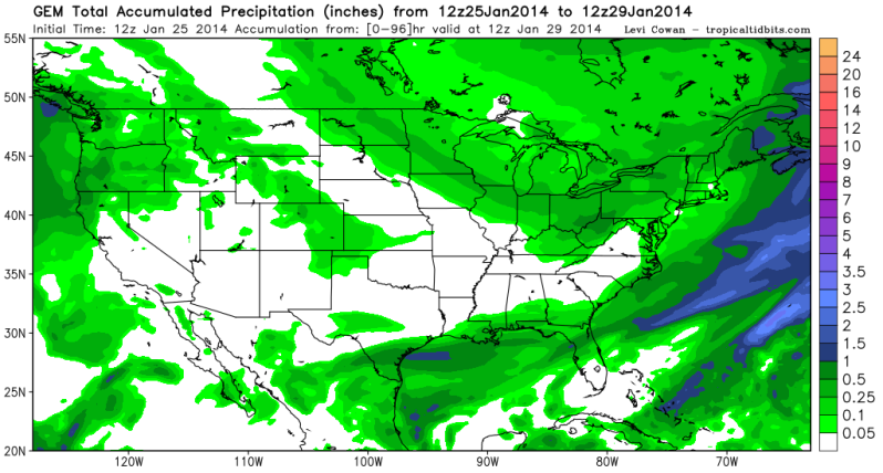
12zGFS
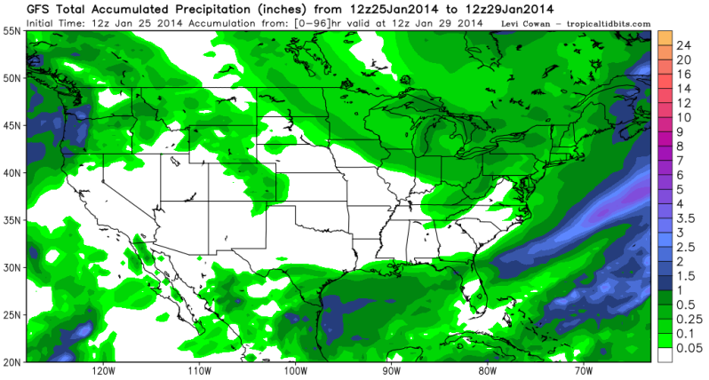
12zGFS Ensembles
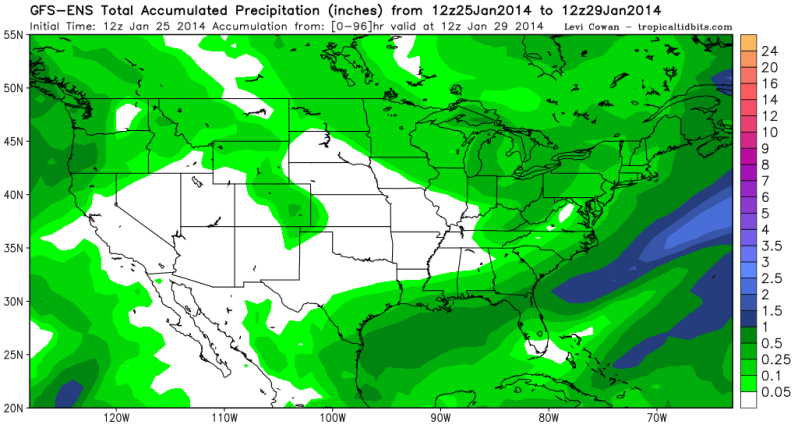
12zCMC

12zGFS

12zGFS Ensembles

0 likes
The following post is NOT an official forecast and should not be used as such. It is just the opinion of the poster and may or may not be backed by sound meteorological data. It is NOT endorsed by any professional institution including storm2k.org For Official Information please refer to the NHC and NWS products.
-
srainhoutx
- S2K Supporter
- Posts: 6919
- Age: 68
- Joined: Sun Jan 14, 2007 11:34 am
- Location: Haywood County, NC
- Contact:
Re: Texas Winter 2013-2014
The 12Z MEX/MAV and MOS text data suggest temperatures will drop into the upper 20's/low 30's behind the front. The text data also suggests wintry weather in the form of freezing rain/sleet and snow albeit light for IAH. Edit to add that the text data is showing about the same for College Station, Conroe, Hobby, Victoria, Lake Charles and lighter amounts for Austin.
Last edited by srainhoutx on Sat Jan 25, 2014 1:40 pm, edited 1 time in total.
0 likes
Carla/Alicia/Jerry(In The Eye)/Michelle/Charley/Ivan/Dennis/Katrina/Rita/Wilma/Ike/Harvey
Member: National Weather Association
Wx Infinity Forums
http://wxinfinity.com/index.php
Facebook.com/WeatherInfinity
Twitter @WeatherInfinity
Member: National Weather Association
Wx Infinity Forums
http://wxinfinity.com/index.php
Facebook.com/WeatherInfinity
Twitter @WeatherInfinity
-
Rgv20
- S2K Supporter
- Posts: 2466
- Age: 39
- Joined: Wed Jan 05, 2011 5:42 pm
- Location: Edinburg/McAllen Tx
Re:
wxman22 wrote:12z Euro looks interesting for the southern half of southeast texas
Yeap, half an inch of Snow for Southern Houston area and up to an 1'' for parts of Brazoria County up to Galveston for Tuesday afternoon..
0 likes
The following post is NOT an official forecast and should not be used as such. It is just the opinion of the poster and may or may not be backed by sound meteorological data. It is NOT endorsed by any professional institution including storm2k.org For Official Information please refer to the NHC and NWS products.
-
Rgv20
- S2K Supporter
- Posts: 2466
- Age: 39
- Joined: Wed Jan 05, 2011 5:42 pm
- Location: Edinburg/McAllen Tx
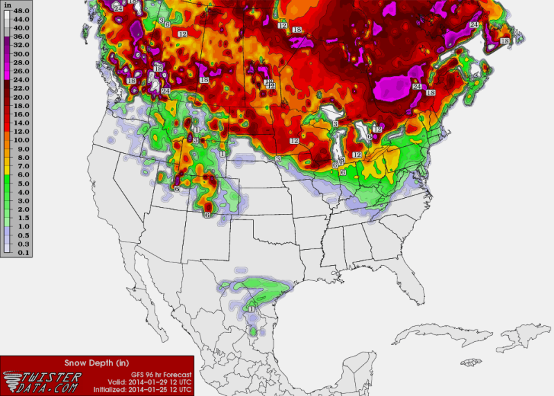
A little eye candy from the 12GFS but as Big O mentioned earlier most of the "Precipitation Type" is mostly Sleet with some Freezing Rain.

0 likes
The following post is NOT an official forecast and should not be used as such. It is just the opinion of the poster and may or may not be backed by sound meteorological data. It is NOT endorsed by any professional institution including storm2k.org For Official Information please refer to the NHC and NWS products.
-
HouTXmetro

- Category 5
- Posts: 3949
- Joined: Sun Jun 13, 2004 6:00 pm
- Location: District of Columbia, USA
Re: Texas Winter 2013-2014
Soo.. I know most models are saying the threat is further south but couldn't we have a situation like last event where the heavier stuff actually ended up North and East? Correct me if I'm wrong but Louisiana was suppose to be relatively dry last event and they ended up getting way more than expected as the event unfolded.
0 likes
[Disclaimer: My Amateur Opinion, please defer to your local authorities or the NHC for Guidance.]
-
wxman22
- Category 5
- Posts: 1928
- Joined: Mon Jan 30, 2006 12:39 am
- Location: Wichita Falls, TX
- Contact:
Re: Texas Winter 2013-2014
I was thinking the same thing, that's always a possibility, remember a couple of days before this weeks event began the models had most of the moisture around the coastal bend region,but the total opposite ended up panning out, at the same time the next cold air mass looks abit drier than this weeks air mass which could make it harder for the system to overcome, time will tell...
0 likes
-
srainhoutx
- S2K Supporter
- Posts: 6919
- Age: 68
- Joined: Sun Jan 14, 2007 11:34 am
- Location: Haywood County, NC
- Contact:
Re: Texas Winter 2013-2014
Update from Jeff:
Nice warm up over the past 24 hours underway today with mainly sunny skies and returning southerly winds.
Warm up will be short lived and another arctic boundary will be plowing through the state by Monday brining another round of cold temperatures.
Upper air pattern remains locked in place with a deep trough over the eastern US and ridge over the western US which continues to send cold arctic air out of NW Canada southward into the plains and Midwest and then toward the east coast. TX is on the western edge of this trough and a slight buckle as seen Thursday will send a piece of these very cold air masses a little bit further south and west across the state. This looks to happen again by early next week with another arctic boundary moving down the plains and off the TX coast.
Expect the boundary to reach the area Monday and push off the coast Monday afternoon. Temperatures will warm into the upper 60’s on Sunday and highs on Monday will be prior to the front and then quickly fall into the 30’s and 40’s behind the boundary with another bout of strong north winds. Temperatures by Tuesday morning look to be freezing or below across nearly all of the area.
Precipitation Chances:
Up until last night this front looked mostly dry with just an increase in clouds, but recent model guidance is now suggesting a piece of energy may drop into the area around Baja and attempt to push moisture northward into the cold air. This brings into question yet again the potential for a mix of winter precipitation starting late Monday into early Tuesday and possibly lasting into late Wednesday. Forecast models are not in good agreement at all on if moisture can push back into the region fighting against the southward push of dry cold arctic air. What is concerning is that yesterday none of the models were suggesting any precipitation at all in the cold air and now today they are all to varying degrees trying to push moisture back into the region from the SSW. Much will likely depend on how the piece of energy near Baja is handled. A more cut-off and stalled piece of energy would likely keep lift and moisture out of the area while a more progressive system would bring moisture and lift back into the cold air. Not enough confidence in either solution at this point to attempt to side one way or the other.
Given the broad spectrum of possibilities at this point and the very low confidence think the best course of action is to lean toward the drier solution and await additional model runs to see if the “wetter” trend holds or increases….if so winter precipitation and potential accumulation will have to be closely examined for the Tuesday-Wednesday period as it appears temperatures will be cold enough to support a mixture of P-types. A wait and see approach for the next 24 hours.
Note:
Model liquid accumulations were on the low side for the last event (Thursday-Friday). Rain gages showed anywhere from .30-.50 of an inch of liquid with ice/sleet accumulations of around .05 to .15 of an inch. Luckily the temperature was above freezing during a good part of the rainfall on Thursday evening or icing would have been much more significant. As proven it only takes a very small amount of ice on roadways to cause really big problems.
Snowfall rations across our northern counties matched very well with the liquid to solid relationship. Amounts averaged 1-2 inches with a couple of 3-4 inch amounts around Lake Livingston. Interestingly the forecast models suggested the greatest band of precip. would be along the I-10 and US 59 corridors when in reality the best banding ended up from College Station to Livingston in an area where it appeared before the event too much dry air would be in place.
0 likes
Carla/Alicia/Jerry(In The Eye)/Michelle/Charley/Ivan/Dennis/Katrina/Rita/Wilma/Ike/Harvey
Member: National Weather Association
Wx Infinity Forums
http://wxinfinity.com/index.php
Facebook.com/WeatherInfinity
Twitter @WeatherInfinity
Member: National Weather Association
Wx Infinity Forums
http://wxinfinity.com/index.php
Facebook.com/WeatherInfinity
Twitter @WeatherInfinity


Still hoping for a phaser, that would be quite a storm for lots of people including parts of the gulf coast. But the major models right now favor a disconnect which is ideal for deep south TX and Nrn Mexico. Lots of time to change as both systems from n and s are still a long way off before good data ingest.
0 likes
The above post and any post by Ntxw is NOT an official forecast and should not be used as such. It is just the opinion of the poster and may or may not be backed by sound meteorological data. It is NOT endorsed by any professional institution including Storm2k. For official information, please refer to NWS products.
Help support Storm2K!
There will not be any precip in North Texas next week. Next week will be much like this week, we get cold and nothing else.
0 likes
The above post and any post by dhweather is NOT an official forecast and should not be used as such. It is just the opinion of the poster and may or may not be backed by sound meteorological data. It is NOT endorsed by any professional institution including storm2k.org. For official information, please refer to NWS products.

Re:
Ntxw wrote:Still hoping for a phaser, that would be quite a storm for lots of people including parts of the gulf coast. But the major models right now favor a disconnect which is ideal for deep south TX and Nrn Mexico. Lots of time to change as both systems from n and s are still a long way off before good data ingest.
I personally don't want it to phase. We got nothing here in Del Rio at all.. a phasing system would leave us high and dry again
0 likes
Anything I post is my personal opinion and should not used for any type of planning or lifesaving reasons. Please refer to National Weather Service forecasts.
Who is online
Users browsing this forum: No registered users and 40 guests