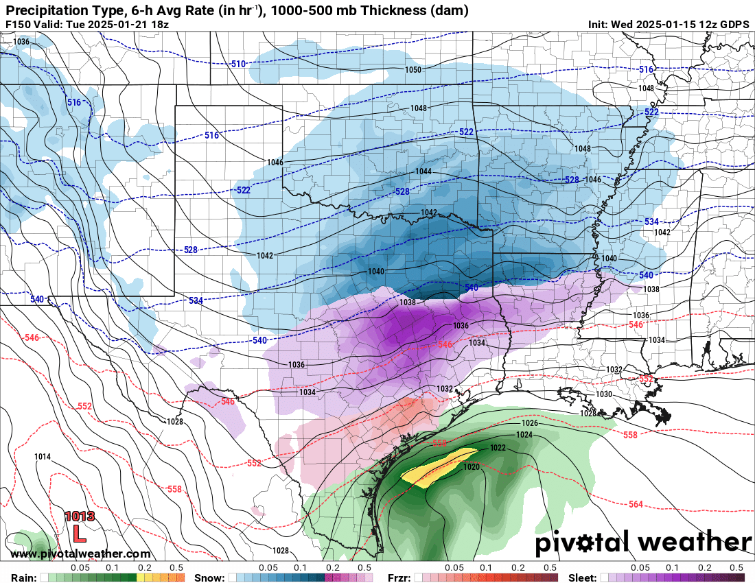
Euro is starting to come around to my thinking on this…
500mb a lot more believable than the garbage on the GFS.
Texas Winter 2024-2025
Moderator: S2k Moderators
Forum rules
 The posts in this forum are NOT official forecast and should not be used as such. They are just the opinion of the poster and may or may not be backed by sound meteorological data. They are NOT endorsed by any professional institution or STORM2K.

The posts in this forum are NOT official forecast and should not be used as such. They are just the opinion of the poster and may or may not be backed by sound meteorological data. They are NOT endorsed by any professional institution or STORM2K.
-
jasons2k

- Storm2k Executive

- Posts: 8290
- Age: 52
- Joined: Wed Jul 06, 2005 12:32 pm
- Location: The Woodlands, TX
Texas Winter 2024-2025
7 likes
-
Ralph's Weather
- S2K Supporter

- Posts: 3371
- Age: 38
- Joined: Fri Dec 13, 2013 11:55 am
- Location: Lindale, TX
- Contact:
Re: Texas Winter 2024-2025
Canadian has a 17k ft DGZ for E TX. 6"+ during just Tue morning. Big warm nose but where no mixing occurs would be an absolute dump. Would be wild to get sleet with surface in the teens, but with enough warm nose I guess its possible for sleet to mix in.
1 likes
Follow on Facebook at Ralph's Weather.
-
Ivanhater

- Storm2k Moderator

- Posts: 11221
- Age: 39
- Joined: Fri Jul 01, 2005 8:25 am
- Location: Pensacola
Re: Texas Winter 2024-2025
Anyone have the freezing rain and sleet map for Gulf coast on Euro.
0 likes
Michael
-
Iceresistance

- Category 5

- Posts: 9574
- Age: 22
- Joined: Sat Oct 10, 2020 9:45 am
- Location: Tecumseh, OK/Norman, OK
Re: Texas Winter 2024-2025
Snowfall ratios are likely 20:1 for Oklahoma on the 12z CMC, around 10°F with snow
https://s13.gifyu.com/images/Sezbk.png
https://s13.gifyu.com/images/Sezbm.png
https://s13.gifyu.com/images/Sezbk.png
https://s13.gifyu.com/images/Sezbm.png
2 likes
Bill 2015 & Beta 2020
Winter 2020-2021
All observations are in Tecumseh, OK unless otherwise noted.
Winter posts are focused mainly for Oklahoma & Texas.
Take any of my forecasts with a grain of salt, refer to the NWS, SPC, and NHC for official information
Never say Never with weather! Because ANYTHING is possible!
Winter 2020-2021
All observations are in Tecumseh, OK unless otherwise noted.
Winter posts are focused mainly for Oklahoma & Texas.
Take any of my forecasts with a grain of salt, refer to the NWS, SPC, and NHC for official information
Never say Never with weather! Because ANYTHING is possible!
-
Iceresistance
- Category 5
- Posts: 9574
- Age: 22
- Joined: Sat Oct 10, 2020 9:45 am
- Location: Tecumseh, OK/Norman, OK
Re: Texas Winter 2024-2025
2 likes
Bill 2015 & Beta 2020
Winter 2020-2021
All observations are in Tecumseh, OK unless otherwise noted.
Winter posts are focused mainly for Oklahoma & Texas.
Take any of my forecasts with a grain of salt, refer to the NWS, SPC, and NHC for official information
Never say Never with weather! Because ANYTHING is possible!
Winter 2020-2021
All observations are in Tecumseh, OK unless otherwise noted.
Winter posts are focused mainly for Oklahoma & Texas.
Take any of my forecasts with a grain of salt, refer to the NWS, SPC, and NHC for official information
Never say Never with weather! Because ANYTHING is possible!

Re: Texas Winter 2024-2025
Ivanhater wrote:Anyone have the freezing rain and sleet map for Gulf coast on Euro.
Will post them in the Deep South thread for you guys.
1 likes
The above post and any post by Ntxw is NOT an official forecast and should not be used as such. It is just the opinion of the poster and may or may not be backed by sound meteorological data. It is NOT endorsed by any professional institution including Storm2k. For official information, please refer to NWS products.
Help support Storm2K!

Re: Texas Winter 2024-2025
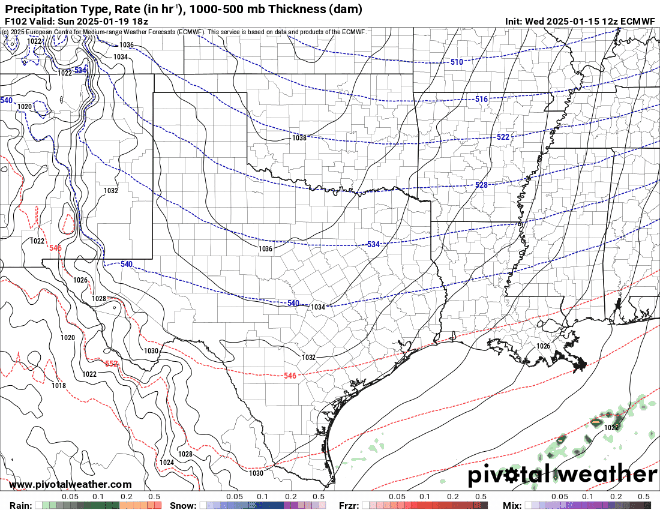
Iceresistance wrote:12z Euro, for the storm
https://s13.gifyu.com/images/Sezb0.gif
https://s13.gifyu.com/images/Sezb0.gif
Looks about right. I remember last Jan the models were showing snow until 2 days before the cold and then it realized It will be too dry. I think something similar will happen this year as well.
0 likes
-
orangeblood
- S2K Supporter
- Posts: 3895
- Joined: Tue Dec 15, 2009 6:14 pm
- Location: Fort Worth, TX
Re: Texas Winter 2024-2025
Ivanhater wrote:Anyone have the freezing rain and sleet map for Gulf coast on Euro.
Mainly Frz Rain


0 likes
-
Stratton23
- Category 5
- Posts: 3511
- Joined: Fri Jul 21, 2023 10:59 pm
- Location: Katy, Tx
Re: Texas Winter 2024-2025
Pattern looks to reload big time beyond the 27th according to the EPS/ GEPS
5 likes
-
wxman57

- Moderator-Pro Met

- Posts: 23170
- Age: 68
- Joined: Sat Jun 21, 2003 8:06 pm
- Location: Houston, TX (southwest)
Re: Texas Winter 2024-2025
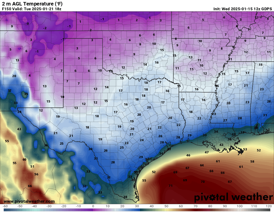
Looking at the EC soundings, that freezing rain area looks more like sleet for SE TX.
7 likes
-
BigB0882
- S2K Supporter
- Posts: 2291
- Joined: Thu Jul 03, 2003 12:08 am
- Location: Baton Rouge, LA
- Contact:
Re: Texas Winter 2024-2025
If snow and ice is laid down in that first round I wouldn’t be surprised to see that 2nd batch of precip be more frozen than it is showing. Temps will probably be lower than what it is calling for. That’s for the Euro.
1 likes
Re: Texas Winter 2024-2025
Ntxw wrote:Lagreeneyes03 wrote:Ntxw wrote:Also don't forget models have been zoning in on a 2nd system the end of the week behind the first one.
Isn't that the one that gives DFW more of a chance, we've gotten shafted in DFW proper (Dallas and Tarrant counties, anyways) for the past few years. Nothing more than 3 in at a time.
I wouldn't call that shafted. That's more than the yearly average, and much more than anything from 2016-2019, a few have been under expectations for sure yeah.
Right.
DFW averages only 2" of snow in a year. So to get any snow at all (which actually DFW been fortunate enough to do for now 5 years in a row) is an achievement...
Last edited by snownado on Wed Jan 15, 2025 1:46 pm, edited 3 times in total.
2 likes
-
captainbarbossa19

- Professional-Met

- Posts: 1094
- Age: 27
- Joined: Wed Aug 21, 2019 11:09 pm
- Location: Beaumont, TX
Re: Texas Winter 2024-2025
wxman57 wrote:Looking at the EC soundings, that freezing rain area looks more like sleet for SE TX.
I need to seriously invest in pivotal weather plus so I can view Euro soundings.
2 likes
-
orangeblood
- S2K Supporter
- Posts: 3895
- Joined: Tue Dec 15, 2009 6:14 pm
- Location: Fort Worth, TX
Re: Texas Winter 2024-2025
12Z Ensemble update....pretty clear looking at snow probabilities for next week which Model is the outlier
Euro ENS

GEPS

GEFS

Euro ENS
GEPS
GEFS
6 likes
-
SnowintheFalls

- S2K Supporter
- Posts: 283
- Age: 48
- Joined: Fri Nov 22, 2013 5:06 pm
- Location: Burkburnett, TX
Re: Texas Winter 2024-2025
Why the big gaps over the Red River? It looks like it just hops right over the Red River counties. lol
0 likes
There is no day like a snow day!
-
jasons2k
- Storm2k Executive
- Posts: 8290
- Age: 52
- Joined: Wed Jul 06, 2005 12:32 pm
- Location: The Woodlands, TX
Re: Texas Winter 2024-2025
SnowintheFalls wrote:Why the big gaps over the Red River? It looks like it just hops right over the Red River counties. lol
Northern stream and coastal trough evolving into a coastal low with a gap in-between.
3 likes
-
HockeyTx82
- S2K Supporter
- Posts: 2777
- Joined: Tue Oct 27, 2009 11:17 am
- Location: Ponder, TX
Re: Texas Winter 2024-2025
SnowintheFalls wrote:Why the big gaps over the Red River? It looks like it just hops right over the Red River counties. lol
They got their snow last time, the Big Snow Industrial Complex is making sure to spread the joy.
4 likes
Don't hold me accountable for anything I post on this forum. Leave the real forecasting up to the professionals.
Location: Ponder, TX (all observation posts are this location unless otherwise noted)
Location: Ponder, TX (all observation posts are this location unless otherwise noted)
-
HockeyTx82
- S2K Supporter
- Posts: 2777
- Joined: Tue Oct 27, 2009 11:17 am
- Location: Ponder, TX
Re: Texas Winter 2024-2025
Throckmorton wrote:Where did the record smashing Arctic air for Austin go? The very high air pressures will be there....
According to the GFS operational model (Jan. 15th, 12Z run), here are the forecasted temperatures, pressures, and snow for Austin Camp Mabry:
59–42...Saturday, 1/18
43–32...Sunday (1033 mb)
45–29...Monday (1035 mb)
36–28...Tuesday (1044 mb) (snow; 2.4 inches)
39–26...Wednesday (1040 mb)
49–38...Thursday (1024 mb)
49–37...Friday
51–33...Saturday, 1/25
61–40...Sunday
And just for fun, here is the Australian ACCESS–G model's forecast for Austin Camp Mabry (Jan. 15th, 00Z run):
58–42...Saturday, 1/18
42–32...Sunday (1028 mb)
37–29...Monday (1029:mb) (snow; 0.4 inches)
38–30...Tuesday (1040 mb) (snow; 0.4 new inches)
48–27...Wednesday (1040 mb)
52–32...Thursday (1032 mb)
46–43...Friday, 1/24 (model run ends at 6 pm CST)
Great question! The absence of Arctic air in the model run despite high pressures can be attributed to several meteorological factors:
1. **Model Resolution**: Weather models have varying resolutions, and sometimes they might not capture smaller-scale features like pockets of Arctic air[43dcd9a7-70db-4a1f-b0ae-981daa162054](https://forum.mmm.ucar.edu/threads/wrf- ... 1daa162054 "1"). This can lead to discrepancies between the model output and actual weather conditions.
2. **Timing and Movement**: Arctic air masses can be highly transient and may move faster or slower than predicted by the model. If the model's timing is slightly off, it might miss the arrival of the cold air.
3. **Atmospheric Dynamics**: High pressure systems can sometimes block or redirect cold air masses. If the high pressure is strong and stable, it might prevent Arctic air from moving southward into the region.
4. **Model Limitations**: No model is perfect, and each has its own biases and limitations. The GFS model, for example, might not always accurately predict the extent or depth of cold air intrusions.
5. **Data Assimilation**: The initial conditions fed into the model can influence its output. If the data assimilation process doesn't fully capture the cold air, the model might not show it.
In summary, while the high pressures are a good indicator of potential cold weather, the actual presence of Arctic air can be influenced by a combination of model resolution, timing, atmospheric dynamics, model limitations, and data assimilation processes.
Does this help clarify things?
4 likes
Don't hold me accountable for anything I post on this forum. Leave the real forecasting up to the professionals.
Location: Ponder, TX (all observation posts are this location unless otherwise noted)
Location: Ponder, TX (all observation posts are this location unless otherwise noted)
-
cheezyWXguy

- Category 5
- Posts: 6280
- Joined: Mon Feb 13, 2006 12:29 am
- Location: Dallas, TX
Re: Texas Winter 2024-2025
HockeyTx82 wrote:Throckmorton wrote:Where did the record smashing Arctic air for Austin go? The very high air pressures will be there....
According to the GFS operational model (Jan. 15th, 12Z run), here are the forecasted temperatures, pressures, and snow for Austin Camp Mabry:
59–42...Saturday, 1/18
43–32...Sunday (1033 mb)
45–29...Monday (1035 mb)
36–28...Tuesday (1044 mb) (snow; 2.4 inches)
39–26...Wednesday (1040 mb)
49–38...Thursday (1024 mb)
49–37...Friday
51–33...Saturday, 1/25
61–40...Sunday
And just for fun, here is the Australian ACCESS–G model's forecast for Austin Camp Mabry (Jan. 15th, 00Z run):
58–42...Saturday, 1/18
42–32...Sunday (1028 mb)
37–29...Monday (1029:mb) (snow; 0.4 inches)
38–30...Tuesday (1040 mb) (snow; 0.4 new inches)
48–27...Wednesday (1040 mb)
52–32...Thursday (1032 mb)
46–43...Friday, 1/24 (model run ends at 6 pm CST)
Great question! The absence of Arctic air in the model run despite high pressures can be attributed to several meteorological factors:
1. **Model Resolution**: Weather models have varying resolutions, and sometimes they might not capture smaller-scale features like pockets of Arctic air[43dcd9a7-70db-4a1f-b0ae-981daa162054](https://forum.mmm.ucar.edu/threads/wrf- ... 1daa162054 "1"). This can lead to discrepancies between the model output and actual weather conditions.
2. **Timing and Movement**: Arctic air masses can be highly transient and may move faster or slower than predicted by the model. If the model's timing is slightly off, it might miss the arrival of the cold air.
3. **Atmospheric Dynamics**: High pressure systems can sometimes block or redirect cold air masses. If the high pressure is strong and stable, it might prevent Arctic air from moving southward into the region.
4. **Model Limitations**: No model is perfect, and each has its own biases and limitations. The GFS model, for example, might not always accurately predict the extent or depth of cold air intrusions.
5. **Data Assimilation**: The initial conditions fed into the model can influence its output. If the data assimilation process doesn't fully capture the cold air, the model might not show it.
In summary, while the high pressures are a good indicator of potential cold weather, the actual presence of Arctic air can be influenced by a combination of model resolution, timing, atmospheric dynamics, model limitations, and data assimilation processes.
Does this help clarify things?
The AI chatbots have descended on S2K
12 likes
Who is online
Users browsing this forum: Stratton23 and 73 guests