Latest SREF gives everyone in north texas moderate to heavy snow tonight and teasingly close to Austin.
Edit : Latest SREF also initialized wrong, says current temps are 43 in Georgetown, when they are actually 33-34 currently.
Texas Winter 2014-2015
Moderator: S2k Moderators
Forum rules
 The posts in this forum are NOT official forecast and should not be used as such. They are just the opinion of the poster and may or may not be backed by sound meteorological data. They are NOT endorsed by any professional institution or STORM2K.

The posts in this forum are NOT official forecast and should not be used as such. They are just the opinion of the poster and may or may not be backed by sound meteorological data. They are NOT endorsed by any professional institution or STORM2K.
-
SouthernMet

- Category 3

- Posts: 857
- Joined: Sun Aug 29, 2010 8:23 pm
- Location: fort worth, tx
Re: Texas Winter 2014-2015
0 likes
Nothing that SouthernMet posts, is an official forecast,nor does it reflect views of STORM2K.. SouthernMet is just adding to the great discussions on STORM2K.. Refer to NWS for official forecasts.

Re: Texas Winter 2014-2015
We break from our regularly scheduled model watching to check on another cat 5 in the gulf ...... 
0 likes
The above post and any post by dhweather is NOT an official forecast and should not be used as such. It is just the opinion of the poster and may or may not be backed by sound meteorological data. It is NOT endorsed by any professional institution including storm2k.org. For official information, please refer to NWS products.
-
SouthernMet
- Category 3
- Posts: 857
- Joined: Sun Aug 29, 2010 8:23 pm
- Location: fort worth, tx
Re: Texas Winter 2014-2015
dhweather we are talking about 10-15 hours out.
0 likes
Nothing that SouthernMet posts, is an official forecast,nor does it reflect views of STORM2K.. SouthernMet is just adding to the great discussions on STORM2K.. Refer to NWS for official forecasts.
-
Brent
- S2K Supporter

- Posts: 38708
- Age: 37
- Joined: Sun May 16, 2004 10:30 pm
- Location: Tulsa Oklahoma
- Contact:
Re: Texas Winter 2014-2015
This is going to happen. I can feel it. It's our turn
Lol
In other news I finally hit 32 degrees
Lol
In other news I finally hit 32 degrees
0 likes
#neversummer
-
Texas Snowman

- Storm2k Moderator

- Posts: 6197
- Joined: Fri Jan 25, 2008 11:29 am
- Location: Denison, Texas
0 likes
The above post and any post by Texas Snowman is NOT an official forecast and should not be used as such. It is just the opinion of the poster and may or may not be backed by sound meteorological data. It is NOT endorsed by any professional institution including storm2k.org. For official information, please refer to NWS products.
NWS Fort Worth/Dallas Winter Weather Update
Submitted by wd5m on Tue, 2015-02-24 15:12
Feb24_15.png
From: National Weather Service, Fort Worth
Date: Tuesday, 24 February 2015 13:51 CST
Good afternoon,
Weak sunshine and slowly rising temperatures will continue to erase the effects of Monday's winter weather event. However, we are expecting a snow event late tonight into Wednesday morning which may bring additional travel impacts to parts of north and central Texas.
Yet another winter weather episode is possible Friday or Saturday, but right now the impacts from that system are not expected to be significant. This message and the attached graphics focus on the details of the winter weather forecast for tonight into Wednesday morning.
BOTTOM LINE:
The system that will affect north and central Texas tonight and early Wednesday is currently over Arizona. This system is strong and fast moving, and its exact track will dictate which areas receive the most snowfall. Accumulating wet snow of 1 inch - ranging up to 3 inches - are possible across parts of north Texas with this event. There is a small chance that a few locations could even see more snow than this, but this is considered a worst case scenario.
With temperatures around 29-33 degrees when the snow is falling, some roadways and especially bridges and overpasses could become snow covered between 4 AM and 10 AM. When the snow ends, temperatures will rebound rapidly into the mid and upper 30s by late morning and into the 40s by Wednesday afternoon, which will greatly limit the probability and duration of slick roadways. There is still uncertainty with regard to which areas of north Texas are likely to see only an inch or so of snow and which areas 3 or more inches. While confidence in the potential for some snow is moderate, our confidence in amounts and impacts is LOW - unlike Monday's sleet event. We may not have a total handle on this event until early Wednesday morning.
AREAS /TIMING:
The snow potential for tonight into Wednesday morning will extend from around midnight to noon. A band of snow will move into western areas by midnight Tuesday night, develop eastward toward the I-35 corridor including the DFW Metroplex by 3 am, and then end in the east before midday. The most likely area to see some accumulating snow will be those areas along and north of a line from Goldthwaite to Waco to Palestine. Somewhere within this larger area, there may be a smaller, relatively narrow band where higher accumulations may occur.
IMPACTS:
The snow that occurs should be relatively wet, and come down in bursts. Slushy snow covered bridges, overpasses, and primary roadways would be the primary impacts during this event. In very isolated areas that receive more than 2 or 3 inches of snow, the weight of that snow could break tree limbs and lead to isolated power outages. The good news is that we expect temperatures to rise above freezing in all areas by mid morning, so the impacts from the snow should be short lived. The chances for any freezing rain or sleet with this particular system are very low.
CONFIDENCE AND ALTERNATE SCENARIOS
Our overall confidence on this snow event is 6 on a scale of 1 to 10. Our confidence is moderate that it will snow and some areas will receive 1 to 3 inches of accumulation. However, our confidence is still low on determining which areas will receive the greatest snow totals. We do have confidence that the precipitation type will be probably be snow, or a mixture of rain and snow. One alternate scenario is that the upper level system will be weaker and slightly warmer over us, producing less accumulating snow and/or more of a rain/snow mix in some areas.
Unlike the sleet event that occurred on Monday, the snow event that develops late tonight is more of a forecast challenge. The areas that have the greatest potential for the highest snow totals may not become apparent until the system moves into north Texas and the precipitation begins to develop later tonight. Stay tuned to the forecast through tonight for any last minute changes that may be needed.
0 likes
The above post and any post by dhweather is NOT an official forecast and should not be used as such. It is just the opinion of the poster and may or may not be backed by sound meteorological data. It is NOT endorsed by any professional institution including storm2k.org. For official information, please refer to NWS products.
-
SouthernMet
- Category 3
- Posts: 857
- Joined: Sun Aug 29, 2010 8:23 pm
- Location: fort worth, tx
Re: Texas Winter 2014-2015
18z HRRR looking really good for snow in north texas...
3am : http://rapidrefresh.noaa.gov/HRRR/jsloo ... omain=full
3am : http://rapidrefresh.noaa.gov/HRRR/jsloo ... omain=full
0 likes
Nothing that SouthernMet posts, is an official forecast,nor does it reflect views of STORM2K.. SouthernMet is just adding to the great discussions on STORM2K.. Refer to NWS for official forecasts.
Re:
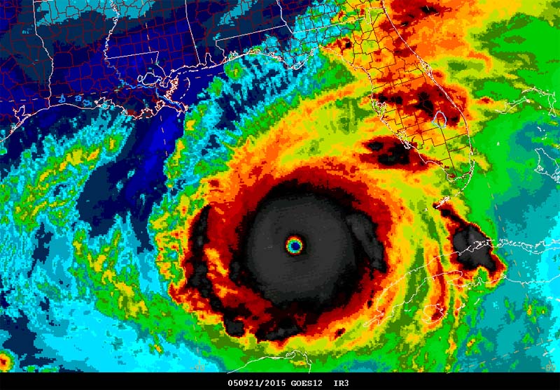
Texas Snowman wrote::uarrow: Rita at peak intensity on 9/21/05. Hard to believe that was going on 10 years ago.
I was thinking about that last night - 10 years ago....
10 years ago we were talking about how ripe the tropics were and how primed things appeared to be for a big year for hurricanes. We had three cat 5's in the gulf that year in Katrina, Rita and Wilma.
0 likes
The above post and any post by dhweather is NOT an official forecast and should not be used as such. It is just the opinion of the poster and may or may not be backed by sound meteorological data. It is NOT endorsed by any professional institution including storm2k.org. For official information, please refer to NWS products.
-
orangeblood
- S2K Supporter
- Posts: 3895
- Joined: Tue Dec 15, 2009 6:14 pm
- Location: Fort Worth, TX
Re: Texas Winter 2014-2015
Incredible how different the NAM is compared to all other Global Models...forecast challenge is an understatement, difference being almost 100 miles between where the axis of heaviest snow will be. And we are less than 18 hours from the event 
0 likes
-
Texas Snowman
- Storm2k Moderator
- Posts: 6197
- Joined: Fri Jan 25, 2008 11:29 am
- Location: Denison, Texas
Re: Re:
dhweather wrote:Texas Snowman wrote::uarrow: Rita at peak intensity on 9/21/05. Hard to believe that was going on 10 years ago.
I was thinking about that last night - 10 years ago....
10 years ago we were talking about how ripe the tropics were and how primed things appeared to be for a big year for hurricanes. We had three cat 5's in the gulf that year in Katrina, Rita and Wilma.
Yeah, most unbelievable hurricane year in my lifetime for sure. The most deadly hurricane since 1928 in Katrina (I went back and looked, official death toll over 1,800); Rita at 180 mph Cat 5 in that picture; and later Wilma at 882 mb as the Atlantic Basin's strongest hurricane ever. I'm glad those kind of Cat 5's are the exception and not the rule.
0 likes
The above post and any post by Texas Snowman is NOT an official forecast and should not be used as such. It is just the opinion of the poster and may or may not be backed by sound meteorological data. It is NOT endorsed by any professional institution including storm2k.org. For official information, please refer to NWS products.
-
Yukon Cornelius
- S2K Supporter
- Posts: 1836
- Age: 42
- Joined: Thu Dec 20, 2012 9:23 pm
- Location: Dean, TX/Westcliffe, CO
Re: Texas Winter 2014-2015
SouthernMet wrote:18z HRRR looking really good for snow in north texas...
3am : http://rapidrefresh.noaa.gov/HRRR/jsloo ... omain=full
By that, I may see a few flakes up in my area!
0 likes
#neversummer
-
Tcu101

- Tropical Storm

- Posts: 174
- Age: 53
- Joined: Wed Jan 29, 2014 6:57 pm
- Location: W Fort Worth/ Benbrook
- Contact:
Re: Texas Winter 2014-2015
43 Hours below freezing at DFW before it finally "warmed up" 
0 likes
Personal Forecast Disclaimer:
The posts in this forum are NOT official forecast and should not be used as such. They are just the opinion of the poster and may or may not be backed by sound meteorological data. They are NOT endorsed by any professional institution or storm2k.org. For official information, please refer to the NHC and NWS products.
The posts in this forum are NOT official forecast and should not be used as such. They are just the opinion of the poster and may or may not be backed by sound meteorological data. They are NOT endorsed by any professional institution or storm2k.org. For official information, please refer to the NHC and NWS products.
-
SouthernMet
- Category 3
- Posts: 857
- Joined: Sun Aug 29, 2010 8:23 pm
- Location: fort worth, tx
Re: Texas Winter 2014-2015
Porta come back we have a chance... http://www.spc.noaa.gov/exper/sref/gifs ... X_f075.gif
Trends are really in our favor in the Austin area for friday. However, tonight is going to be close.
Trends are really in our favor in the Austin area for friday. However, tonight is going to be close.
0 likes
Nothing that SouthernMet posts, is an official forecast,nor does it reflect views of STORM2K.. SouthernMet is just adding to the great discussions on STORM2K.. Refer to NWS for official forecasts.
-
Ralph's Weather
- S2K Supporter
- Posts: 3371
- Age: 38
- Joined: Fri Dec 13, 2013 11:55 am
- Location: Lindale, TX
- Contact:
Looks like the models are again underestimating how strongly surface cold holds on especially with thick cloud cover and ice on the ground. They had us getting well into the 40s by now yet we still sit at 32. The issue is the models for tonight are expecting that it will take some rain to cool the low levels before the snow starts sticking. Instead we look to start out plenty cold for snow thus totals will be higher as will ratios. At 35 degrees we would have rain mixed with 6:1 ratio type snow at 32 it will be more like 9:1 or better and all snow. For this reason I could see a large area of 4"+ and a sizable area of 6"+ in NE TX.
0 likes
Follow on Facebook at Ralph's Weather.
-
Portastorm

- Storm2k Moderator
- Posts: 9954
- Age: 63
- Joined: Fri Jul 11, 2003 9:16 am
- Location: Round Rock, TX
- Contact:
Re: Texas Winter 2014-2015
SouthernMet wrote:Porta come back we have a chance... http://www.spc.noaa.gov/exper/sref/gifs ... X_f075.gif
Trends are really in our favor in the Austin area for friday. However, tonight is going to be close.
Alright ... SouthernMet has pulled me out of the drunk tank, forced a couple of cups of coffee down my throat, and is holding this SREF in front of my face ... sobering me up.
0 likes
Any forecasts under my name are to be taken with a grain of salt. Get your best forecasts from the National Weather Service and National Hurricane Center.
-
Texas Snowman
- Storm2k Moderator
- Posts: 6197
- Joined: Fri Jan 25, 2008 11:29 am
- Location: Denison, Texas
Re: Texas Winter 2014-2015
Portastorm wrote:SouthernMet wrote:Porta come back we have a chance... http://www.spc.noaa.gov/exper/sref/gifs ... X_f075.gif
Trends are really in our favor in the Austin area for friday. However, tonight is going to be close.
Alright ... SouthernMet has pulled me out of the drunk tank, forced a couple of cups of coffee down my throat, and is holding this SREF in front of my face ... sobering me up.
Remember, that Grey Goose is to CELEBRATE your winter weather victories, not your defeats at the hands of Heat Miser.
I'm pulling for you tonight and most especially on Friday my friend!!!
0 likes
The above post and any post by Texas Snowman is NOT an official forecast and should not be used as such. It is just the opinion of the poster and may or may not be backed by sound meteorological data. It is NOT endorsed by any professional institution including storm2k.org. For official information, please refer to NWS products.
-
orangeblood
- S2K Supporter
- Posts: 3895
- Joined: Tue Dec 15, 2009 6:14 pm
- Location: Fort Worth, TX
Re:
Ralph's Weather wrote:Looks like the models are again underestimating how strongly surface cold holds on especially with thick cloud cover and ice on the ground. They had us getting well into the 40s by now yet we still sit at 32. The issue is the models for tonight are expecting that it will take some rain to cool the low levels before the snow starts sticking. Instead we look to start out plenty cold for snow thus totals will be higher as will ratios. At 35 degrees we would have rain mixed with 6:1 ratio type snow at 32 it will be more like 9:1 or better and all snow. For this reason I could see a large area of 4"+ and a sizable area of 6"+ in NE TX.
So where's your axis of heaviest snowfall ? Euro/Canadian/Ukmet are all along I-20 or south from Dallas to Shreveport while NAM is north of I-30 from Dallas to Texarkana
0 likes
-
orangeblood
- S2K Supporter
- Posts: 3895
- Joined: Tue Dec 15, 2009 6:14 pm
- Location: Fort Worth, TX
Re: Texas Winter 2014-2015
Portastorm wrote:SouthernMet wrote:Porta come back we have a chance... http://www.spc.noaa.gov/exper/sref/gifs ... X_f075.gif
Trends are really in our favor in the Austin area for friday. However, tonight is going to be close.
Alright ... SouthernMet has pulled me out of the drunk tank, forced a couple of cups of coffee down my throat, and is holding this SREF in front of my face ... sobering me up.
Don't fall for the "Poor man's Plumes" Porta, they've burned me WAY more times than I can remember.
0 likes
-
Texas Snowman
- Storm2k Moderator
- Posts: 6197
- Joined: Fri Jan 25, 2008 11:29 am
- Location: Denison, Texas
Re: Texas Winter 2014-2015
SouthernMet wrote:Porta come back we have a chance... http://www.spc.noaa.gov/exper/sref/gifs ... X_f075.gif
Trends are really in our favor in the Austin area for friday. However, tonight is going to be close.
Wow, now that would be something on Friday. Really, really something. Hang in there Portastorm!!!
0 likes
The above post and any post by Texas Snowman is NOT an official forecast and should not be used as such. It is just the opinion of the poster and may or may not be backed by sound meteorological data. It is NOT endorsed by any professional institution including storm2k.org. For official information, please refer to NWS products.
Who is online
Users browsing this forum: Cpv17 and 101 guests