Airport weather warning just issued for DFW acknowledges potential for 4-5 inches if the moderate/heavy band moves over the airport. It also acknowledges the potential for 0.50"/hr liquid equivalent rates which would be fairly staggering snow rates. Seems like they might need to issue a warning as soon as they're sure where the heaviest band will set up.
This really has the feel of something significant for DFW. Good luck to you guys down in Austin. I hope you can get in on the action also!
Texas Winter 2014-2015
Moderator: S2k Moderators
Forum rules
 The posts in this forum are NOT official forecast and should not be used as such. They are just the opinion of the poster and may or may not be backed by sound meteorological data. They are NOT endorsed by any professional institution or STORM2K.

The posts in this forum are NOT official forecast and should not be used as such. They are just the opinion of the poster and may or may not be backed by sound meteorological data. They are NOT endorsed by any professional institution or STORM2K.
-
Longhornmaniac8

- Category 1

- Posts: 261
- Joined: Thu Nov 18, 2010 2:30 am
- Location: Austin, TX
Re: Texas Winter 2014-2015
hriverajr wrote:It's still digging to southeast imo. No east turn yet..
I would agree. If it continues its trajectory, the center will pass just south of El Paso.
0 likes
-
Wntrwthrguy
- Tropical Storm

- Posts: 161
- Joined: Thu Nov 21, 2013 8:48 pm
- Location: North Austin
Re: Texas Winter 2014-2015
JDawg512 wrote:TarrantWx wrote:hriverajr wrote:It's still digging to southeast imo. No east turn yet..
Could the system digging further southeast indicate that its taking on more of a neutral to negative tilt than expected?
That's how it seems to me, it looks like it's nudging to the south.
I don't see how Austin will be dry slotted, not with how far south the radar returns are,
Unless the precip is moving northeast. Always seems to miss us. Hoping the low moves more south than the models have predicted but not getting my hopes up.
0 likes
Any post should not be taken as a forecast. I am just an amateur living the dream.

Re: Texas Winter 2014-2015
Bands out west are starting to pick up with intensity. We are certainly off to a good start, but we have a long ways to go. 
0 likes
-
Yukon Cornelius
- S2K Supporter

- Posts: 1836
- Age: 42
- Joined: Thu Dec 20, 2012 9:23 pm
- Location: Dean, TX/Westcliffe, CO
Re: Texas Winter 2014-2015
Hoping for a little snow at least up here. If not, Friday definitely looks promising.
0 likes
#neversummer

Re: Texas Winter 2014-2015
iorange55 wrote:Bands out west are starting to pick up with intensity. We are certainly off to a good start, but we have a long ways to go.
You know, Feb 11 started out with a band that come up from the south and dumped a quick two inches overnight before the main storm even came out. Just advisories for 1-2 inches.
0 likes
The above post and any post by Ntxw is NOT an official forecast and should not be used as such. It is just the opinion of the poster and may or may not be backed by sound meteorological data. It is NOT endorsed by any professional institution including Storm2k. For official information, please refer to NWS products.
Help support Storm2K!
-
Texas Snowman

- Storm2k Moderator

- Posts: 6197
- Joined: Fri Jan 25, 2008 11:29 am
- Location: Denison, Texas
WHERE IS PORTASTORM?!?!?!? 
0 likes
The above post and any post by Texas Snowman is NOT an official forecast and should not be used as such. It is just the opinion of the poster and may or may not be backed by sound meteorological data. It is NOT endorsed by any professional institution including storm2k.org. For official information, please refer to NWS products.
Re: Texas Winter 2014-2015
Ntxw wrote:iorange55 wrote:Bands out west are starting to pick up with intensity. We are certainly off to a good start, but we have a long ways to go.
You know, Feb 11 started out with a band that come up from the south and dumped a quick two inches overnight before the main storm even came out. Just advisories for 1-2 inches.
I remember.
0 likes
-
orangeblood
- S2K Supporter
- Posts: 3895
- Joined: Tue Dec 15, 2009 6:14 pm
- Location: Fort Worth, TX
Re: Texas Winter 2014-2015
Latest WRF has an eye popping 4-6" amounts covering the entire Metroplex....much more in line with the latest short range models
0 likes
Re: Texas Winter 2014-2015
orangeblood wrote:Latest WRF has an eye popping 4-6" amounts covering the entire Metroplex....much more in line with the latest short range models
I would not be surprised if FW switched to winter storm warnings, I think it warrants it basically along interstate 20...
0 likes
The above post and any post by Ntxw is NOT an official forecast and should not be used as such. It is just the opinion of the poster and may or may not be backed by sound meteorological data. It is NOT endorsed by any professional institution including Storm2k. For official information, please refer to NWS products.
Help support Storm2K!
Help support Storm2K!
-
Texas Snowman
- Storm2k Moderator
- Posts: 6197
- Joined: Fri Jan 25, 2008 11:29 am
- Location: Denison, Texas
I can only hope some of that will nudge its way up to northern Grayson County!
0 likes
The above post and any post by Texas Snowman is NOT an official forecast and should not be used as such. It is just the opinion of the poster and may or may not be backed by sound meteorological data. It is NOT endorsed by any professional institution including storm2k.org. For official information, please refer to NWS products.
-
Tcu101

- Tropical Storm
- Posts: 174
- Age: 53
- Joined: Wed Jan 29, 2014 6:57 pm
- Location: W Fort Worth/ Benbrook
- Contact:
Re:
TarrantWx wrote:Airport weather warning just issued for DFW acknowledges potential for 4-5 inches if the moderate/heavy band moves over the airport. It also acknowledges the potential for 0.50"/hr liquid equivalent rates which would be fairly staggering snow rates. Seems like they might need to issue a warning as soon as they're sure where the heaviest band will set up.
This really has the feel of something significant for DFW. Good luck to you guys down in Austin. I hope you can get in on the action also!
link?
0 likes
Personal Forecast Disclaimer:
The posts in this forum are NOT official forecast and should not be used as such. They are just the opinion of the poster and may or may not be backed by sound meteorological data. They are NOT endorsed by any professional institution or storm2k.org. For official information, please refer to the NHC and NWS products.
The posts in this forum are NOT official forecast and should not be used as such. They are just the opinion of the poster and may or may not be backed by sound meteorological data. They are NOT endorsed by any professional institution or storm2k.org. For official information, please refer to the NHC and NWS products.
Re: Texas Winter 2014-2015
iorange55 wrote:Ntxw wrote:iorange55 wrote:Bands out west are starting to pick up with intensity. We are certainly off to a good start, but we have a long ways to go.
You know, Feb 11 started out with a band that come up from the south and dumped a quick two inches overnight before the main storm even came out. Just advisories for 1-2 inches.
I remember.Just refreshed the radar. Storms are really beginning to pop southwest!!!
That's it. Two thirty it is. Not sure if sleep is possible but crap I have to work early. This is too much fun. A large surprise is coming for a lot of Texas folks. Good luck too all!!

0 likes

Re: Texas Winter 2014-2015
Wntrwthrguy wrote:
Unless the precip is moving northeast. Always seems to miss us. Hoping the low moves more south than the models have predicted but not getting my hopes up.
That is true, if the main bulk of the precipitation moves to the northeast then it would skirt us but so far it looks like it's spreading east reaching Junction.
0 likes
Resident Rain Miser
I am a weather hobbyist living 3.5 miles south of Downtown Austin and in no way or fashion should anything I say concerning forecasts be taken seriously. Please check your local NWS for accurate weather forecasting and conditions.
I am a weather hobbyist living 3.5 miles south of Downtown Austin and in no way or fashion should anything I say concerning forecasts be taken seriously. Please check your local NWS for accurate weather forecasting and conditions.
-
aggiecutter
- Category 5

- Posts: 1754
- Joined: Thu Oct 14, 2004 9:22 pm
- Location: Texarkana
Re: Texas Winter 2014-2015
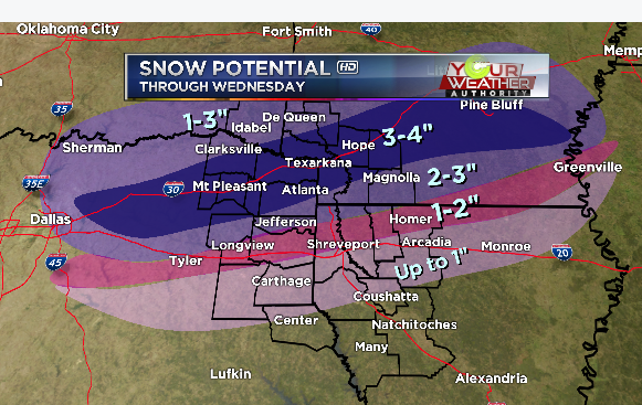
Latest Snowfall potential from Todd Warren's Futurecast Weather Model:

0 likes

-
Texas Snowman
- Storm2k Moderator
- Posts: 6197
- Joined: Fri Jan 25, 2008 11:29 am
- Location: Denison, Texas
It's going to be more than that. That'd be my guess for snowfall totals in N and NE Texas.
Last edited by Texas Snowman on Tue Feb 24, 2015 9:23 pm, edited 1 time in total.
0 likes
The above post and any post by Texas Snowman is NOT an official forecast and should not be used as such. It is just the opinion of the poster and may or may not be backed by sound meteorological data. It is NOT endorsed by any professional institution including storm2k.org. For official information, please refer to NWS products.
-
Brent
- S2K Supporter
- Posts: 38708
- Age: 37
- Joined: Sun May 16, 2004 10:30 pm
- Location: Tulsa Oklahoma
- Contact:
Re:
TarrantWx wrote:Airport weather warning just issued for DFW acknowledges potential for 4-5 inches if the moderate/heavy band moves over the airport. It also acknowledges the potential for 0.50"/hr liquid equivalent rates which would be fairly staggering snow rates. Seems like they might need to issue a warning as soon as they're sure where the heaviest band will set up.
This really has the feel of something significant for DFW. Good luck to you guys down in Austin. I hope you can get in on the action also!
Link please?
0 likes
#neversummer
Re: Re:
Brent wrote:TarrantWx wrote:Airport weather warning just issued for DFW acknowledges potential for 4-5 inches if the moderate/heavy band moves over the airport. It also acknowledges the potential for 0.50"/hr liquid equivalent rates which would be fairly staggering snow rates. Seems like they might need to issue a warning as soon as they're sure where the heaviest band will set up.
This really has the feel of something significant for DFW. Good luck to you guys down in Austin. I hope you can get in on the action also!
Link please?
http://kamala.cod.edu/tx/latest.wwus84.KFWD.html
067
WWUS84 KFWD 250150
AWWDFW
TXZ118-119-250800-
AIRPORT WEATHER WARNING
NATIONAL WEATHER SERVICE FORT WORTH TX
750 PM CST TUE FEB 24 2015
..AIRPORT WEATHER WARNING FOR FREEZING/FROZEN PRECIPITATION
ONSET/END TIMES
2-3 AM THROUGH 9-10 AM
ACCUMULATIONS/PRECIP TYPE/TIMING
RAIN WILL BEGIN AFTER MIDNIGHT AND WILL START TO MIX WITH SNOW AND
POSSIBLY SOME SLEET BEGINNING 2-3 AM. THE MIX WILL TRANSITION TO
ALL SNOW AROUND 5-7 AM. THE SNOW IS EXPECTED TO END BY 10 AM.
ACCUMULATIONS OF SLEET WILL BE A TRACE. ACCUMULATIONS OF SNOW WILL
BE 1-3 INCHES WITH POSSIBLY UP TO 4-5 INCHES IF A BAND OF MODERATE
TO HEAVY SNOW MOVES OVER THE AIRPORT.
TIME/S/ TEMPERATURE FALLS BELOW /RISES ABOVE/ FREEZING
WILL HOVER AROUND FREEZING AFTER MIDNIGHT BUT EXPECT TO BE 30-31
DEGREES FROM 5 AM THROUGH 9 AM.
PRECIP RATES GTE ONE HALF INCH AN HOUR ONSET/DURATION
LIQUID EQUIVALENT RATES OF GTE 1/2 INCH MAY OCCUR IN BANDS OF
MODERATE TO HEAVY SNOW...IF ONE AFFECTS THE AIRPORT...BETWEEN
6-10 AM.
OTHER THREATS/REMARKS
A WINTER WEATHER ADVISORY REMAINS IN EFFECT FROM MIDNIGHT THROUGH
NOON.
0 likes
-
Portastorm

- Storm2k Moderator
- Posts: 9954
- Age: 63
- Joined: Fri Jul 11, 2003 9:16 am
- Location: Round Rock, TX
- Contact:
Re:
Texas Snowman wrote:WHERE IS PORTASTORM?!?!?!?
I'm here buddy ... I'm watching circumspectly.
0 likes
Any forecasts under my name are to be taken with a grain of salt. Get your best forecasts from the National Weather Service and National Hurricane Center.
Who is online
Users browsing this forum: SnowyOwl31, Yukon Cornelius and 92 guests