Texas Winter 2010-2011

Winter Weather Discussion

Moderator: S2k Moderators

Forum rules

The posts in this forum are NOT official forecast and should not be used as such. They are just the opinion of the poster and may or may not be backed by sound meteorological data. They are NOT endorsed by any professional institution or STORM2K.

Help Support Storm2K
Message
Author
benrayrog
Tropical Depression
Tropical Depression
Posts: 53
Age: 66
Joined: Mon Feb 22, 2010 4:35 pm
Location: Malakoff

Re:

#6141 Postby benrayrog » Thu Feb 03, 2011 7:49 am

missytingarland wrote:Good morning! I'm new here but a long time lurker. I currently live in Garland but I grew up in Sherman. My dad was a sherriff's deputy in the day before all the fancy radars, so he would have to go out storm chasing and I spent many days/nights out with him watching storms and tornados. So now I'm a weather junkie. Just wanted to introduce myself and say this winter weather is definitely NOT my fav!


Welcome!
0 likes   

Tejas89
Category 1
Category 1
Posts: 429
Joined: Mon Dec 28, 2009 9:25 pm
Location: DFW, TX

Re: Texas Winter 2010-2011

#6142 Postby Tejas89 » Thu Feb 03, 2011 7:55 am

Well, crud, I was hoping for a record low out of this extended freeze at DFW. No such luck. This morning was our best chance.
0 likes   

User avatar
txagwxman
Professional-Met
Professional-Met
Posts: 960
Joined: Thu Dec 24, 2009 3:26 pm
Location: Tomball, TX

#6143 Postby txagwxman » Thu Feb 03, 2011 7:57 am

Light precip already starting to form west of Houston. :eek:
0 likes   
“If you thought that science was certain - well, that is just an error on your part.”

GRAYSONCO.WX
Category 1
Category 1
Posts: 450
Joined: Thu Jan 06, 2011 4:29 pm
Location: Denison, Texas

Re:

#6144 Postby GRAYSONCO.WX » Thu Feb 03, 2011 8:07 am

txagwxman wrote:Light precip already starting to form west of Houston. :eek:

HRRR showing anything interesting?
0 likes   

austinrunner

Re: Texas Winter 2010-2011

#6145 Postby austinrunner » Thu Feb 03, 2011 8:10 am

NWS Austin/San Antonio apparently missed a new record low maximum of 26 degrees at Mabry on February 2. I could not find an announcement of this event. The all-time lowest maximum temperature at Mabry/Mueller Airport is 20. When was the last time that Mabry failed to reach 30 for a high?
0 likes   

austinrunner

Re: Re:

#6146 Postby austinrunner » Thu Feb 03, 2011 8:15 am

GRAYSONCO.WX wrote:
txagwxman wrote:Light precip already starting to form west of Houston. :eek:

HRRR showing anything interesting?

Yep!
http://rapidrefresh.noaa.gov/hrrrconus/ ... =t5&wjet=1

Between 7pm and 8pm tonight, between .1 and .5 inches of snow progged to accumulate in Travis and Williamson counties.
http://rapidrefresh.noaa.gov/hrrrconus/ ... =t5&wjet=1
0 likes   

GRAYSONCO.WX
Category 1
Category 1
Posts: 450
Joined: Thu Jan 06, 2011 4:29 pm
Location: Denison, Texas

Re: Re:

#6147 Postby GRAYSONCO.WX » Thu Feb 03, 2011 8:24 am

austinrunner wrote:
GRAYSONCO.WX wrote:
txagwxman wrote:Light precip already starting to form west of Houston. :eek:

HRRR showing anything interesting?

Yep!
http://rapidrefresh.noaa.gov/hrrrconus/ ... =t5&wjet=1

Between 7pm and 8pm tonight, between .1 and .5 inches of snow progged to accumulate in Travis and Williamson counties.
http://rapidrefresh.noaa.gov/hrrrconus/ ... =t5&wjet=1

Very interesting indeed! The last couple frames of the run show a lot of precip developing around the waco area! Assume that'll move north toward Dallas..
0 likes   

User avatar
Portastorm
Storm2k Moderator
Storm2k Moderator
Posts: 9914
Age: 63
Joined: Fri Jul 11, 2003 9:16 am
Location: Round Rock, TX
Contact:

Re: Texas Winter 2010-2011

#6148 Postby Portastorm » Thu Feb 03, 2011 8:29 am

austinrunner wrote:NWS Austin/San Antonio apparently missed a new record low maximum of 26 degrees at Mabry on February 2. I could not find an announcement of this event. The all-time lowest maximum temperature at Mabry/Mueller Airport is 20. When was the last time that Mabry failed to reach 30 for a high?


austinrunner, I posted about this last night. Yesterday Mabry had the coldest max temp since February 1989.
0 likes   

User avatar
TeamPlayersBlue
Category 5
Category 5
Posts: 3445
Joined: Tue Feb 02, 2010 1:44 am
Location: Denver/Applewood, CO

#6149 Postby TeamPlayersBlue » Thu Feb 03, 2011 8:32 am

Wow, moisture is picking up. Lets see how this plays out

Is this hitting the ground in Lufkin or beaumont?
0 likes   
Personal Forecast Disclaimer:
The posts in this forum are NOT official forecast and should not be used as such. They are just the opinion of the poster and may or may not be backed by sound meteorological data. They are NOT endorsed by any professional institution or storm2k.org. For official information, please refer to the NHC and NWS products.

User avatar
txagwxman
Professional-Met
Professional-Met
Posts: 960
Joined: Thu Dec 24, 2009 3:26 pm
Location: Tomball, TX

#6150 Postby txagwxman » Thu Feb 03, 2011 8:41 am

Beaumont may get more than I thought.
0 likes   
“If you thought that science was certain - well, that is just an error on your part.”

User avatar
srainhoutx
S2K Supporter
S2K Supporter
Posts: 6919
Age: 67
Joined: Sun Jan 14, 2007 11:34 am
Location: Haywood County, NC
Contact:

Re: Texas Winter 2010-2011

#6151 Postby srainhoutx » Thu Feb 03, 2011 8:50 am

email from Jeff Thursday morning:

***Winter Storm Warning issued for all of SE TX, coastal bend, S TX, and SW LA***


Historic winter storm event within 8-12 hours of starting.


Do not think we will get the entire evening rush hour in before the event starts.


I will begin hourly updates starting at 100pm this afternoon.


Discussion:

Powerful upper level low continues to dig into northern Mexico this morning with increasing moisture clearly noted on radar and satellite images. Starting to get a few returns on the radar images this morning, but very dry sub-cloud layer is evaporating prior to the precip. reaching the ground..this process will continue for the morning before the low levels saturate and then the main show begins. Looks at the forecast soundings this morning, still believe the best course of action is to go with more sleet and snow than ice and will go ahead and bump snowfall totals up a tad across the entire area to fit with more snow than sleet/freezing rain.


Timing:

Starting to see some light sleet over Galveston Island in the last hour and echoes on the radar are increasing along the US 59 corridor and down around Corpus Christi. So far only GLS has reported anything reaching the ground as that low level air mass is very dry. Expect to see the radar echoes intensify this morning and saturate the low levels first on the coast and then spreading inland. It is very hard to determine how long it will take to bring the low levels to saturation, but once that point is reached precip. will reach the ground. Will go with onset of precip. reaching the ground 1-2pm along the coast and 300-400pm along US 59 including metro Houston and then all regions by 600pm. Road conditions will deteriorate very quickly once precip onsets with road temperatures at or below freezing both on bridges/overpasses and on surface streets.


Accumulations:

Will hit the entire area with 1-3 inches this includes the coastal bend, all of SE TX and into SW LA. Feel along and about 40-50 miles NW of US 59 is where the greatest totals will be with isolated amounts upwards of 4-5 inches possible. The only location where some freezing rain may fall is right along the coast from Freeport to Galveston Island and then inland toward southern Liberty County…will go with ice accumulations of .1-.25 of an inch in this region and then an inch of snow on top of the ice. Models continue to advertise convective nature to the event supporting the threat of meso bands with heavy snow. SPC has in fact placed a large part of the area under a thunderstorm risk for tonight supporting the threat for some convective events within the overall snow shield.


It is likely that everyone will see some accumulation, but where the biggest totals will be is nearly impossible to predict under the event is underway.


Temperatures:

Expect temperatures to hover at or below freezing all day and then in the mid to upper 20’s tonight and below freezing all day on Friday. May see a few locations rise to near 32-35 for an hour Friday afternoon if skies clear, but a rapid fall Friday night under clearings skies and light winds…with snow cover will result in lows back into the low 20’s for nearly all areas.


Travel:

Extremely dangerous travel conditions will be developing across the entire region and by early evening surface travel will be difficult. Travel on Friday will be nearly impossible and all residents are being urged to drive only if it is an emergency. Do not expect roads to recover until maybe sometime on Saturday afternoon. Ground crews will attempt to keep sanding operations ongoing, but given the size of this event will quickly be overwhelmed


Aviation:

It is going to get bad at the airports and suspect ground operations will not be able to keep the airports open. Continental has already cancelled all operations starting at 300pm today until noon Friday. Aircraft that depart will require extensive de-icing operations and snow removal operations for runways. Suspect at some point likely tonight that these operations will be suspended due to the storm intensity.


Power:

ERCOT has ordered another round of rotating blackouts from 600-800am this morning to conserve power on the TX grid. With more of a threat of snow/sleet feel that most power infrastructure will be OK during this event, except near the coast and Galveston bay where freezing rain may be possible with some ice accumulations.
0 likes   
Carla/Alicia/Jerry(In The Eye)/Michelle/Charley/Ivan/Dennis/Katrina/Rita/Wilma/Ike/Harvey

Member: National Weather Association
Wx Infinity Forums
http://wxinfinity.com/index.php

Facebook.com/WeatherInfinity
Twitter @WeatherInfinity

User avatar
txagwxman
Professional-Met
Professional-Met
Posts: 960
Joined: Thu Dec 24, 2009 3:26 pm
Location: Tomball, TX

#6152 Postby txagwxman » Thu Feb 03, 2011 8:54 am

GEM still +.30" of precip.

UKMET .25"
0 likes   
“If you thought that science was certain - well, that is just an error on your part.”

austinrunner

500 mb standard deviation forecast maps

#6153 Postby austinrunner » Thu Feb 03, 2011 8:55 am

I'm familiar with standard deviations being expressed in numbers like 1.0, 2.0, and 3.0. But I don't understand the 500 mb standard deviation forecast maps here:
http://www.esrl.noaa.gov/psd/map/images ... times.html
The scale ranges from 0 to 200, with no negative numbers. Can someone explain this in a layperson's terms?
0 likes   

austinrunner

Re: Texas Winter 2010-2011

#6154 Postby austinrunner » Thu Feb 03, 2011 8:57 am

Portastorm wrote:
austinrunner wrote:NWS Austin/San Antonio apparently missed a new record low maximum of 26 degrees at Mabry on February 2. I could not find an announcement of this event. The all-time lowest maximum temperature at Mabry/Mueller Airport is 20. When was the last time that Mabry failed to reach 30 for a high?


austinrunner, I posted about this last night. Yesterday Mabry had the coldest max temp since February 1989.


Thanks! I missed your post. Was there an official NWS announcement that I also missed?
0 likes   

PineyWoods
Tropical Storm
Tropical Storm
Posts: 127
Joined: Sat Feb 03, 2007 3:39 pm
Location: Tyler

Re: Texas Winter 2010-2011

#6155 Postby PineyWoods » Thu Feb 03, 2011 9:08 am

We have been getting sleet pellets here in Tyler for about 15". Nothing major, but starting the precip earlier than I thought. Sitting at 20° currently
0 likes   

User avatar
Texas Snowman
Storm2k Moderator
Storm2k Moderator
Posts: 6179
Joined: Fri Jan 25, 2008 11:29 am
Location: Denison, Texas

Re: Texas Winter 2010-2011

#6156 Postby Texas Snowman » Thu Feb 03, 2011 9:17 am

srainhoutx wrote:email from Jeff Thursday morning:

Historic winter storm event within 8-12 hours of starting.


This whole "La Nina" winter seems historic in many ways.

A frigid January in the Lone Star State and good North Texas snow event.

A Super Bowl XLV special that includes a sleet/snow/freezing rain storm and a severe Arctic air mass for Jerry's big party at the Death Star.

Now a south Texas snow event waiting in the wings and maybe even more snow and cold in Texas early next week.

And it's not just us - multiple power-house snow events in New England and the Mid-Atlantic; a huge blizzard this week in Oklahoma, Kansas, Missouri, and Illinois; and snow in the south a couple of times already.

20 years from now, we'll talk about the winters of 2009/10 and 2010/11 in the same hushed tones that we currently talk about the winters of 1976 and 1977, the Dec. 1983 freeze, the 1989 freeze, and the 1996 freeze.

The "La Nada" winter that keeps on giving... :D
0 likes   
The above post and any post by Texas Snowman is NOT an official forecast and should not be used as such. It is just the opinion of the poster and may or may not be backed by sound meteorological data. It is NOT endorsed by any professional institution including storm2k.org. For official information, please refer to NWS products.

User avatar
southerngale
Retired Staff
Retired Staff
Posts: 27418
Joined: Thu Oct 10, 2002 1:27 am
Location: Southeast Texas (Beaumont area)

Re: Texas Winter 2010-2011

#6157 Postby southerngale » Thu Feb 03, 2011 9:21 am

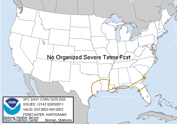
srainhoutx posted this in the SE TX thread. Thundersnow or thundersleet possible? Down here? Unreal, IF it were to occur.

And there have been many reports already this morning of light sleet and/or snow. I haven't seen anything yet.


srainhoutx wrote:This could be a very interesting 24 hours...

Image

DAY 1 CONVECTIVE OUTLOOK
NWS STORM PREDICTION CENTER NORMAN OK
0614 AM CST THU FEB 03 2011

VALID 031300Z - 041200Z

...NO SVR TSTM AREAS FORECAST...

AN EXPANSIVE UPPER TROUGH IS IN PLACE THIS MORNING OVER THE
CONTIGUOUS UNITED STATES...WITH COLD AND RELATIVELY DRY CONDITIONS
EVERYWHERE BUT FL. A SURFACE COLD FRONT CONTINUES TO SAG SLOWLY
SOUTHWARD ACROSS THE NORTHERN FL PENINSULA...AND IS PROVIDING A
FOCUS FOR SCATTERED SHOWERS AND THUNDERSTORMS. MODELS SUGGEST THIS
THREAT WILL PERSIST THROUGH THE MORNING HOURS BEFORE SLOWLY
DIMINISHING THIS AFTERNOON.

FARTHER WEST...INCREASING LARGE SCALE FORCING AND LOW LEVEL WARM
ADVECTION WILL RESULT IN AN EXPANDING AREA OF PRECIPITATION THIS
AFTERNOON THROUGH TONIGHT OVER THE GULF COAST STATES. MODEL
GUIDANCE SUGGESTS VERY WEAK ELEVATED INSTABILITY /CENTERED AROUND
600MB/ WILL DEVELOP OVER SOUTHEAST TX/SOUTHWEST LA. THIS AREA MAY
SEE A FEW LIGHTNING STRIKES IN THE MOST ORGANIZED SHOWERS TONIGHT.


..HART/GRAMS.. 02/03/2011
0 likes   
Please support Storm2k by making a donation today. It is greatly appreciated! Click here: Image

Image my Cowboys Image my RocketsImage my Astros

serenata09
Tropical Storm
Tropical Storm
Posts: 166
Joined: Fri Jan 18, 2008 7:55 pm
Location: Dallas, TX

Re: Texas Winter 2010-2011

#6158 Postby serenata09 » Thu Feb 03, 2011 9:23 am

Radar returns seem to be lighting up over the coastal bend from Beaumont down to Corpus! I hope you all get some winter precip. excitement!
0 likes   

User avatar
northtxboy
Category 1
Category 1
Posts: 262
Age: 43
Joined: Mon Jan 03, 2011 1:50 pm
Location: Windom Tx
Contact:

Re: Texas Winter 2010-2011

#6159 Postby northtxboy » Thu Feb 03, 2011 9:24 am

Texas Snowman wrote:
srainhoutx wrote:email from Jeff Thursday morning:

Historic winter storm event within 8-12 hours of starting.


This whole "La Nina" winter seems historic in many ways.

A frigid January in the Lone Star State and good North Texas snow event.

A Super Bowl XLV special that includes a sleet/snow/freezing rain storm and a severe Arctic air mass for Jerry's big party at the Death Star.

Now a south Texas snow event waiting in the wings and maybe even more snow and cold in Texas early next week.

And it's not just us - multiple power-house snow events in New England and the Mid-Atlantic; a huge blizzard this week in Oklahoma, Kansas, Missouri, and Illinois; and snow in the south a couple of times already.

20 years from now, we'll talk about the winters of 2009/10 and 2010/11 in the same hushed tones that we currently talk about the winters of 1976 and 1977, the Dec. 1983 freeze, the 1989 freeze, and the 1996 freeze.

The "La Nada" winter that keeps on giving... :D

Didnt you hear!!!! Its globel warming!!! the earth is getting hotter so it gets colder!? I guess
0 likes   

snow4444
Tropical Low
Tropical Low
Posts: 29
Joined: Tue Feb 01, 2011 1:25 pm

#6160 Postby snow4444 » Thu Feb 03, 2011 9:25 am

A decnt looking snow band just to the west of DFW wee should see what happens with shortly.
0 likes   


Return to “Winter Weather”

Who is online

Users browsing this forum: No registered users and 5 guests