Texas Winter 2014-2015
Moderator: S2k Moderators
Forum rules
 The posts in this forum are NOT official forecast and should not be used as such. They are just the opinion of the poster and may or may not be backed by sound meteorological data. They are NOT endorsed by any professional institution or STORM2K.

The posts in this forum are NOT official forecast and should not be used as such. They are just the opinion of the poster and may or may not be backed by sound meteorological data. They are NOT endorsed by any professional institution or STORM2K.
-
Tcu101

- Tropical Storm

- Posts: 174
- Age: 53
- Joined: Wed Jan 29, 2014 6:57 pm
- Location: W Fort Worth/ Benbrook
- Contact:
Within the next hour or so the warm nose show be just about gone per the 07Z RAP
0 likes
Personal Forecast Disclaimer:
The posts in this forum are NOT official forecast and should not be used as such. They are just the opinion of the poster and may or may not be backed by sound meteorological data. They are NOT endorsed by any professional institution or storm2k.org. For official information, please refer to the NHC and NWS products.
The posts in this forum are NOT official forecast and should not be used as such. They are just the opinion of the poster and may or may not be backed by sound meteorological data. They are NOT endorsed by any professional institution or storm2k.org. For official information, please refer to the NHC and NWS products.
-
Texas Snowman

- Storm2k Moderator

- Posts: 6197
- Joined: Fri Jan 25, 2008 11:29 am
- Location: Denison, Texas
Delkus is really downplaying this it seems on Facebook: "Rain continues to fall across most of North Texas early this morning. A transition to snow is expected by 5 a.m. at the latest. Uncertainty remains in terms of total snow accumulation but many areas may still see at least 2 inches of snow before all of this ends by 9-10 a.m. #wfaaweather"
0 likes
The above post and any post by Texas Snowman is NOT an official forecast and should not be used as such. It is just the opinion of the poster and may or may not be backed by sound meteorological data. It is NOT endorsed by any professional institution including storm2k.org. For official information, please refer to NWS products.


-
Tcu101
- Tropical Storm
- Posts: 174
- Age: 53
- Joined: Wed Jan 29, 2014 6:57 pm
- Location: W Fort Worth/ Benbrook
- Contact:
Re:
Texas Snowman wrote:Delkus is really downplaying this it seems on Facebook: "Rain continues to fall across most of North Texas early this morning. A transition to snow is expected by 5 a.m. at the latest. Uncertainty remains in terms of total snow accumulation but many areas may still see at least 2 inches of snow before all of this ends by 9-10 a.m. #wfaaweather"
He was also the one that posted " Light Sleet Accumulations" on his 6pm newscast the evening before last storm even though the NWS had upgraded things to a warning
0 likes
Personal Forecast Disclaimer:
The posts in this forum are NOT official forecast and should not be used as such. They are just the opinion of the poster and may or may not be backed by sound meteorological data. They are NOT endorsed by any professional institution or storm2k.org. For official information, please refer to the NHC and NWS products.
The posts in this forum are NOT official forecast and should not be used as such. They are just the opinion of the poster and may or may not be backed by sound meteorological data. They are NOT endorsed by any professional institution or storm2k.org. For official information, please refer to the NHC and NWS products.
-
somethingfunny

- ChatStaff

- Posts: 3926
- Age: 37
- Joined: Thu May 31, 2007 10:30 pm
- Location: McKinney, Texas
The waiting is the hardest part...
We have been so busy at my pizzeria this past week, we have enough pizza boxes for 80 pizzas tomorrow and that's it. We're out of wings, ranch, parmesean cheese packets.... and we're hearing that the scheduled truck may not come tomorrow/today because their facility was closed today/yesterday. Figuring out what day this is is difficult when you're a night owl.
I've made a ton of cash and earned a bunch of overtime too, so I'm hoping this snow is just bad enough to give me another few bonanzas but not bad enough to prevent our truck from coming in, because we can't open the store without that truck delivery. :\
0 likes
I am not a meteorologist, and any posts made by me are not official forecasts or to be interpreted as being intelligent. These posts are just my opinions and are probably silly opinions.
-
Brent
- S2K Supporter

- Posts: 38708
- Age: 37
- Joined: Sun May 16, 2004 10:30 pm
- Location: Tulsa Oklahoma
- Contact:
Re: Texas Winter 2014-2015
Getting more and more sleet as the minutes wear on here... just started about 10 minutes ago
0 likes
#neversummer

Light rain/sleet mix in Sherman. And I was just about to nap.
Edit: Temp 30.5, dewpoint 29
Edit: Temp 30.5, dewpoint 29
Last edited by STX Expat on Wed Feb 25, 2015 4:32 am, edited 1 time in total.
0 likes
The opinions expressed in this post are NOT forecasts. I am an amatuer enthusiast - NOT a professional meteorologist.
-
somethingfunny
- ChatStaff
- Posts: 3926
- Age: 37
- Joined: Thu May 31, 2007 10:30 pm
- Location: McKinney, Texas

Re: Texas Winter 2014-2015
IT'S HAPPENING DALLAS!!!! I SAW A SNOW ECHO OVER TRAVIS COUNTY AS WELL EARLIER....THE TREND IS OUR FRIEND.... 
0 likes
-
Brent
- S2K Supporter
- Posts: 38708
- Age: 37
- Joined: Sun May 16, 2004 10:30 pm
- Location: Tulsa Oklahoma
- Contact:
Re: Texas Winter 2014-2015
This sucks.
Haven't we had enough 32 and rain this winter??
Come on already.
In more positive thinking the blue area is expanding on weatherbug from the north...
Haven't we had enough 32 and rain this winter??
Come on already.
In more positive thinking the blue area is expanding on weatherbug from the north...
0 likes
#neversummer

Re: Texas Winter 2014-2015
32 and all rain in Denton. Don't believe the blue on the radar.
0 likes
Tammie - Sherman TX
-
Brent
- S2K Supporter
- Posts: 38708
- Age: 37
- Joined: Sun May 16, 2004 10:30 pm
- Location: Tulsa Oklahoma
- Contact:
Re: Texas Winter 2014-2015

MESOSCALE DISCUSSION 0095
NWS STORM PREDICTION CENTER NORMAN OK
0332 AM CST WED FEB 25 2015
AREAS AFFECTED...PARTS OF N-CNTRL TX / EXTREME SERN OK AND NWRN LA /
SWRN AR
CONCERNING...WINTER MIXED PRECIPITATION
VALID 250932Z - 251530Z
SUMMARY...MIXED P-TYPE PRIMARILY IN THE FORM OF FREEZING RAIN IS
INITIALLY FORECAST FROM NEAR THE N-CNTRL TX I-35 CORRIDOR EWD INTO
THE ARKLATEX. FREEZING RAIN RATES 0.05-0.15 INCH PER 3 HOURS ARE
POSSIBLE WHERE TEMPS REMAIN AT OR BELOW FREEZING. MODERATE TO HEAVY
SNOW --RATES APPROACHING/AROUND 1 INCH PER HOUR-- IS POSSIBLE
GENERALLY AFTER 11 UTC OVER PARTS OF N-CNTRL TX AND EVENTUALLY
FARTHER ENE INTO SERN OK/SWRN AR THIS MORNING.
DISCUSSION...RADAR MOSAIC SHOWS AN EXPANDING PRECIP SHIELD OVER
N-CNTRL TX INTO NERN TX AHEAD OF A MID-LEVEL LOW/TROUGH LOCATED OVER
FAR W TX. SURFACE ANALYSIS AT 09Z SHOWS TEMPS AROUND 32 FROM THE
N-SIDE OF THE DFW METROPLEX AND INCLUDING AREAS E INTO NERN TX. THE
00Z FWD RAOB SHOWED A SIZABLE LAYER AOA FREEZING /H85-H7/.
MOISTENING AND ASCENT IN THE AFOREMENTIONED LAYER HAS CONSIDERABLY
COOLED THIS LAYER OVERNIGHT. BASED ON SURFACE OBSERVATIONS AND
MODEL FORECAST SOUNDINGS IT APPEARS A FREEZING RAIN THREAT IS
BEGINNING OVER NERN TX. FREEZING RAIN RATES 0.05-0.15 INCH PER 3
HOURS SEEM LIKELY WITH HEAVIER BURSTS 0.10-0.15 INCH PER 1 HOUR
POSSIBLE IN LOCALIZED AREAS BASED ON OBSERVED RATES NEAR DFW.
ADDITIONAL MID-LEVEL COLUMNAR COOLING IS FORECAST AND A EVENTUAL
TRANSITION TO MIX OF FREEZING RAIN/SLEET IS EXPECTED.
AS INCREASING MID-LEVEL ASCENT /DCVA/ ASSOCIATED WITH THE
APPROACHING DISTURBANCE AND STRENGTHENING MID-LEVEL FRONTOGENETIC
FORCING ALONG THE N-SIDE OF THE PRECIP SHIELD OCCURS TOWARDS
MORNING...A CORRIDOR OF MODERATE TO HEAVY SNOWFALL RATES /1 INCH PER
HOUR/ IS FORECAST TO DEVELOP AND SUBSEQUENTLY SPREAD DOWNSTREAM FROM
N-CNTRL TX INTO SWRN AR.
..SMITH.. 02/25/2015
0 likes
#neversummer
Re: Texas Winter 2014-2015
Pete Delkus @wfaaweather 2m2 minutes ago
Heaviest snow will directly impact the morning commute. Here's what to expect at 5, 6, 7 and 8 am. #wfaaweather
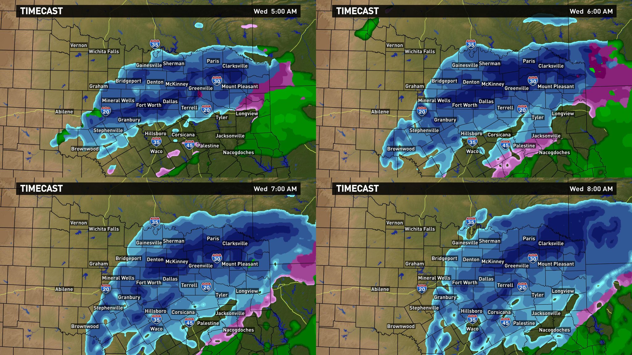
Heaviest snow will directly impact the morning commute. Here's what to expect at 5, 6, 7 and 8 am. #wfaaweather
0 likes
Texas Storm Chasers just posted a video update
https://www.facebook.com/video.php?v=10153063315609654
https://www.facebook.com/video.php?v=10153063315609654
0 likes
-
Ralph's Weather
- S2K Supporter
- Posts: 3371
- Age: 38
- Joined: Fri Dec 13, 2013 11:55 am
- Location: Lindale, TX
- Contact:
Models are showing some crazy snow amounts. All models are currently showing at minimum 3" with most averaging closer to 6" across N and NE Texas with a couple 15" spots on the 08Z RAP. I was worried about 2010esque totals yesterday and looks like that was valid. This may be the craziest weather event I have ever closely followed. A day ago we though maybe some rain or a light mix.
0 likes
Follow on Facebook at Ralph's Weather.
-
Brent
- S2K Supporter
- Posts: 38708
- Age: 37
- Joined: Sun May 16, 2004 10:30 pm
- Location: Tulsa Oklahoma
- Contact:
Re: Texas Winter 2014-2015
NBC 5 says it should be changing over very soon rapidly...
also says FWD is still considering a winter storm warning
also says FWD is still considering a winter storm warning
0 likes
#neversummer
-
Ralph's Weather
- S2K Supporter
- Posts: 3371
- Age: 38
- Joined: Fri Dec 13, 2013 11:55 am
- Location: Lindale, TX
- Contact:
Re: Texas Winter 2014-2015
Brent wrote:NBC 5 says it should be changing over very soon rapidly...
also says FWD is still considering a winter storm warning
They better be with all models showing at least 4" and some much more.
0 likes
Follow on Facebook at Ralph's Weather.


Who is online
Users browsing this forum: No registered users and 89 guests