Texas winter wx thread (2009-2010)

Winter Weather Discussion

Moderator: S2k Moderators

Forum rules

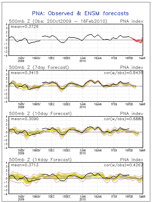
The posts in this forum are NOT official forecast and should not be used as such. They are just the opinion of the poster and may or may not be backed by sound meteorological data. They are NOT endorsed by any professional institution or STORM2K.

Help Support Storm2K
Message
Author
User avatar
southerngale
Retired Staff
Retired Staff
Posts: 27418
Joined: Thu Oct 10, 2002 1:27 am
Location: Southeast Texas (Beaumont area)

Re: Texas winter wx thread (2009-2010)

#7321 Postby southerngale » Mon Feb 15, 2010 6:07 pm

Texas Snowman wrote:
somethingfunny wrote:When I came home today I saw that the ruler I'd placed on the front yard had finally fallen over and was resting on a small patch of remnant ice. :( We hardly knew ye, snow. Please come back soon!


Frosty the Snowman had to hurry on his way. But he waved goodbye saying don't you cry, I'll be back again some day... :wink:

:lol:


I had a high of 46° today and a low of 29° this morning. No sleet last night that I'm aware of, just rain, of course. I was out last night and when I went into the building, it was "warm" - I had on long sleeves and was comfortable. The power went out 3 times, the longest lasting about a minute, and when I went outside, I wished I had brought my jacket inside as it was COLD and WINDY! I also dodged quite a few large limbs in the street on my way home.
0 likes   
Please support Storm2k by making a donation today. It is greatly appreciated! Click here: Image

Image my Cowboys Image my RocketsImage my Astros

utweather
Category 1
Category 1
Posts: 252
Joined: Tue Jan 26, 2010 10:51 pm
Location: SE Austin, TX

Re: Texas winter wx thread (2009-2010)

#7322 Postby utweather » Mon Feb 15, 2010 6:22 pm

orangeblood wrote:It has a storm moving through Texas on Sunday bringing winter weather into Oklahoma and the North Texas red river counties. In its wake, the 850mb 0 degree C line moves down to San Antonio and College Station. With the cold air in place, a S/W appears to be moving into South Central Texas from Northern Mexico on Tuesday.

In my opinion, this model has been one of the better models in picking up on longer term trends this winter so it bears watching.


Yeah, that may be our last chance to get burried alive this winter :wink:
0 likes   

User avatar
txagwxman
Professional-Met
Professional-Met
Posts: 960
Joined: Thu Dec 24, 2009 3:26 pm
Location: Tomball, TX

#7323 Postby txagwxman » Mon Feb 15, 2010 9:25 pm

NWS 27F tonight my side of town...NAM 2m temps low 30s.
Even ECMWF has 546 thickness DFW on Sunday with precip...getting close.
0 likes   
“If you thought that science was certain - well, that is just an error on your part.”

User avatar
Ntxw
Storm2k Moderator
Storm2k Moderator
Posts: 22792
Joined: Wed Oct 21, 2009 6:34 pm
Location: DFW, Texas

#7324 Postby Ntxw » Mon Feb 15, 2010 10:01 pm

:uarrow: As long as they trend wetter and colder I'm happy :D
0 likes   
The above post and any post by Ntxw is NOT an official forecast and should not be used as such. It is just the opinion of the poster and may or may not be backed by sound meteorological data. It is NOT endorsed by any professional institution including Storm2k. For official information, please refer to NWS products.

  Help support Storm2K!
Help Support Storm2K

Peanut432
Tropical Storm
Tropical Storm
Posts: 119
Joined: Mon Jan 25, 2010 10:21 pm
Location: Hollis Ok

Re: Texas winter wx thread (2009-2010)

#7325 Postby Peanut432 » Mon Feb 15, 2010 11:35 pm

Are the new models saying anything different?
0 likes   

User avatar
iorange55
Category 5
Category 5
Posts: 2388
Joined: Thu Nov 13, 2008 9:47 pm
Location: Big D

Re: Texas winter wx thread (2009-2010)

#7326 Postby iorange55 » Mon Feb 15, 2010 11:44 pm

The 00z GFS continues to look very weird. I don't get it. After day 7 or so it shows a lot of cold air, and a strong push behind it. But then it stops in Oklahoma for a day or two before plunging down into Texas. Causing a winter storm around day 10 or 11 I believe. But the whole run looks very weird.

I don't trust it.
0 likes   

User avatar
Portastorm
Storm2k Moderator
Storm2k Moderator
Posts: 9914
Age: 63
Joined: Fri Jul 11, 2003 9:16 am
Location: Round Rock, TX
Contact:

Re: Texas winter wx thread (2009-2010)

#7327 Postby Portastorm » Tue Feb 16, 2010 7:44 am

Admittedly, I'm at a loss to understand why the operational runs are not showing "multiple" winter storm threats for Texas, given how the Arctic Oscillation is severely negative, the North Atlantic Oscillation is negative, and the PNA (Pacific North American pattern) is positive. Oh yeah, El Nino region figures remain at least moderate suggesting an active subtropical jet (STJ).

These signs have shown up frequently this winter and they remain. All suggest strong winter-like conditions over much of the USA.

Even trying to take aside my obvious desire for one more big storm in Texas, the GFS and Euro *should* be showing multiple type threats based on the aforementioned factors. I don't get it. :double:
0 likes   

User avatar
srainhoutx
S2K Supporter
S2K Supporter
Posts: 6919
Age: 67
Joined: Sun Jan 14, 2007 11:34 am
Location: Haywood County, NC
Contact:

Re: Texas winter wx thread (2009-2010)

#7328 Postby srainhoutx » Tue Feb 16, 2010 8:00 am

Pattern is giving the models fits! :wink:

PRELIMINARY EXTENDED FORECAST DISCUSSION
NWS HYDROMETEOROLOGICAL PREDICTION CENTER CAMP SPRINGS MD
402 AM EST TUE FEB 16 2010

VALID 12Z SAT FEB 20 2010 - 12Z TUE FEB 23 2010


USED THE 00Z/16 ECMWF FOR THE PRELIMINARY FRONTS AND PRESSURES
DAYS 3-6...BLENDING IN ABOUT A THIRD OF THE 12Z/15 ECENS MEAN DAY
7 MAINLY TO SOFTEN THE CYCLOGENESIS SIGNATURE ALONG THE EAST
COAST. THE ECMWF HAS THE BEST CONTINUITY WITH THE SPLIT FLOW OFF
THE WEST COAST COMING INTO THE MEDIUM RANGE...AND SUSPECT THAT THE
DIFFERENCE BETWEEN IT AND THE REST OF THE GUIDANCE DAY 3 OVER THE
EASTERN PACIFIC FACTORS HEAVILY INTO THE EVENTUAL DEVELOPMENT OF A
MAJOR SYNOPTIC WAVE DOWNSTREAM ON THE ATLANTIC COAST OF NORTH
AMERICA. DURING THE PAST WEEK...THE GFS...AND THEN THE ECMWF
DEVELOPED A STRONG CYCLONE OFF THE MID ATLANTIC COAST AROUND THE
22ND OF THE MONTH...AND HAVE SUBSEQUENTLY BACKED OFF THAT IDEA.

THE CURRENT CYCLE BRINGS THE WAVE BACK...WITH THE GFS ON THE FLAT
END OF THE ENVELOPE...THE GEM GLOBAL DEVELOPING A DEEP LOW
OFFSHORE...AND THE ECMWF BOMBING OUT A MONSTER RIGHT ALONG THE
ATLANTIC SEABOARD...ALONG THE LINES OF THE ORIGINAL SOLUTIONS
DEPICTING THE EVENT.
THE INCORPORATION OF THE MOST RECENT EC MEAN
SHOULD TAKE SOME OF THE BITE OUT OF A MASSIVE ERROR ON THE PART OF
THE ECMWF...BUT...THE PRELIMINARY MANUAL PROGS ARE STILL PRO-STORM
WHEN ALL IS SAID AND DONE.
THE BLOCK GETS SO STRONG THIS
PERIOD...THAT THE SYSTEMS COMING INTO THE WEST COAST GET RIPPED TO
PIECES...WITH POOR ONSHORE FLOW
.


CISCO
0 likes   
Carla/Alicia/Jerry(In The Eye)/Michelle/Charley/Ivan/Dennis/Katrina/Rita/Wilma/Ike/Harvey

Member: National Weather Association
Wx Infinity Forums
http://wxinfinity.com/index.php

Facebook.com/WeatherInfinity
Twitter @WeatherInfinity

User avatar
txagwxman
Professional-Met
Professional-Met
Posts: 960
Joined: Thu Dec 24, 2009 3:26 pm
Location: Tomball, TX

#7329 Postby txagwxman » Tue Feb 16, 2010 9:05 am

UKMET still interesting next Monday....
Image
0 likes   
“If you thought that science was certain - well, that is just an error on your part.”

User avatar
srainhoutx
S2K Supporter
S2K Supporter
Posts: 6919
Age: 67
Joined: Sun Jan 14, 2007 11:34 am
Location: Haywood County, NC
Contact:

Re: Texas winter wx thread (2009-2010)

#7330 Postby srainhoutx » Tue Feb 16, 2010 9:10 am

Interesting that the PNA continues to rise and not decline...

Image

Also note the spread between the GFS and the ECMWF at hour 168...

Image
0 likes   
Carla/Alicia/Jerry(In The Eye)/Michelle/Charley/Ivan/Dennis/Katrina/Rita/Wilma/Ike/Harvey

Member: National Weather Association
Wx Infinity Forums
http://wxinfinity.com/index.php

Facebook.com/WeatherInfinity
Twitter @WeatherInfinity

User avatar
Portastorm
Storm2k Moderator
Storm2k Moderator
Posts: 9914
Age: 63
Joined: Fri Jul 11, 2003 9:16 am
Location: Round Rock, TX
Contact:

Re: Texas winter wx thread (2009-2010)

#7331 Postby Portastorm » Tue Feb 16, 2010 10:02 am

:uarrow:

I might normally post "c'mon guys, the UKMET?!?!" ... but given this pattern and the fact that all the modeling appears to be clueless beyond three days, I guess anything is possible, right?! :lol:
0 likes   

User avatar
txagwxman
Professional-Met
Professional-Met
Posts: 960
Joined: Thu Dec 24, 2009 3:26 pm
Location: Tomball, TX

Re: Texas winter wx thread (2009-2010)

#7332 Postby txagwxman » Tue Feb 16, 2010 10:14 am

Portastorm wrote::uarrow:

I might normally post "c'mon guys, the UKMET?!?!" ... but given this pattern and the fact that all the modeling appears to be clueless beyond three days, I guess anything is possible, right?! :lol:

Image

UKMET 2nd best performing model this winter.
0 likes   
“If you thought that science was certain - well, that is just an error on your part.”

User avatar
Portastorm
Storm2k Moderator
Storm2k Moderator
Posts: 9914
Age: 63
Joined: Fri Jul 11, 2003 9:16 am
Location: Round Rock, TX
Contact:

Re: Texas winter wx thread (2009-2010)

#7333 Postby Portastorm » Tue Feb 16, 2010 10:22 am

Yowzah! :eek:

I'm an Anglophile when it comes to my rock music but always heard the UKMET was a poor performer. I guess not. At least this winter! Thanks for that, txagwxman. BTW, where can we access that information online?

Go Brits ... I hope you're right next week.

Edit update: nevermind, found the link.
0 likes   

msstateguy83

Re: Texas winter wx thread (2009-2010)

#7334 Postby msstateguy83 » Tue Feb 16, 2010 11:39 am

this weekend is still not clear due to models not getting a good handle on everything BUT i would almost
say take it to the bank sometime after tuesday next week into the next weekend expect a MAJOR ARCTIC
OUTBREAK with the chance of a huge WINTER STORM over OK/TX... :cold:

edit: just look at the gfs at 192 hrs out and you will see what i mean :wink:
it is showing ALOT of VERY cold arctic air bottled up trying to come south into the us...
12z is still running so we shall see if it brings it south or not shortly...

edit 2: now at 204 hrs out it seems to lift back north at one point i just saw on i think it was the 192 hr
frame temps in swrn canada near 50 below zero. then it pushed back northward. BOTTOM LINE i dont think
the models are handling this situation very well at all, who knows what the next week to two weeks has
in store for us but i know one thing the gfs is way to warm on our temps i dont buy it for one sec!
Last edited by msstateguy83 on Tue Feb 16, 2010 11:52 am, edited 1 time in total.
0 likes   

WacoWx
Category 2
Category 2
Posts: 664
Joined: Mon Dec 28, 2009 4:14 pm
Location: NOT Waco, TX ----> Dallas, TX

Re: Texas winter wx thread (2009-2010)

#7335 Postby WacoWx » Tue Feb 16, 2010 11:50 am

like the cut of your jib ^^^
0 likes   

User avatar
srainhoutx
S2K Supporter
S2K Supporter
Posts: 6919
Age: 67
Joined: Sun Jan 14, 2007 11:34 am
Location: Haywood County, NC
Contact:

Re: Texas winter wx thread (2009-2010)

#7336 Postby srainhoutx » Tue Feb 16, 2010 12:00 pm

Give it a couple of days folks. CARCAH has tasked Pacific RECON (G-IV from Japan and C-130 from Anchorage), so we will likely see things settle down with guidance. :wink:

000
NOUS42 KNHC 151745
WEATHER RECONNAISSANCE FLIGHTS
CARCAH, NATIONAL HURRICANE CENTER, MIAMI, FL.
1245 PM EST MON 15 FEBRUARY 2010
SUBJECT: WINTER STORM PLAN OF THE DAY (WSPOD)
VALID 16/1100Z TO 17/1100Z FEBRUARY 2010
WSPOD NUMBER.....09-077

I. ATLANTIC REQUIREMENTS
1. NEGATIVE RECONNAISSANCE REQUIREMENTS.
2. SUCCEEDING DAY OUTLOOK.....NEGATIVE

II. PACIFIC REQUIREMENTS
1. FLIGHT ONE - TEAL 70
A. P29/ 37.5N 146.8W/ 17/1200Z
B. AFXXX 30WSC TRACK29
C. 17/0600Z
D. 18 DROPS ON TRACK
E. AS HIGH AS POSSIBLE/ 17/1800Z

2. OUTLOOK FOR SUCCEEDING DAY:
FLIGHT ONE - TEAL 71
A. P29/ 37.5N 146.8W/ 18/1200Z

FLIGHT TWO - NOAA 49
A. P99/ TBD/ 18/1200Z
JWP
Last edited by srainhoutx on Tue Feb 16, 2010 12:04 pm, edited 1 time in total.
0 likes   
Carla/Alicia/Jerry(In The Eye)/Michelle/Charley/Ivan/Dennis/Katrina/Rita/Wilma/Ike/Harvey

Member: National Weather Association
Wx Infinity Forums
http://wxinfinity.com/index.php

Facebook.com/WeatherInfinity
Twitter @WeatherInfinity

User avatar
txagwxman
Professional-Met
Professional-Met
Posts: 960
Joined: Thu Dec 24, 2009 3:26 pm
Location: Tomball, TX

#7337 Postby txagwxman » Tue Feb 16, 2010 12:00 pm

Too much -PNA on the GFS that is why the cold having a tough time pushing south. See what the other models do.
0 likes   
“If you thought that science was certain - well, that is just an error on your part.”

User avatar
txagwxman
Professional-Met
Professional-Met
Posts: 960
Joined: Thu Dec 24, 2009 3:26 pm
Location: Tomball, TX

#7338 Postby txagwxman » Tue Feb 16, 2010 12:09 pm

GFS ensembles are not as cold next week...
BUT was it over when the Germans bombed Pearl Harbor? :wink:
0 likes   
“If you thought that science was certain - well, that is just an error on your part.”

User avatar
southerngale
Retired Staff
Retired Staff
Posts: 27418
Joined: Thu Oct 10, 2002 1:27 am
Location: Southeast Texas (Beaumont area)

#7339 Postby southerngale » Tue Feb 16, 2010 12:13 pm

I hope I'm wrong, but my gut says:

Listen
0 likes   
Please support Storm2k by making a donation today. It is greatly appreciated! Click here: Image

Image my Cowboys Image my RocketsImage my Astros

User avatar
srainhoutx
S2K Supporter
S2K Supporter
Posts: 6919
Age: 67
Joined: Sun Jan 14, 2007 11:34 am
Location: Haywood County, NC
Contact:

Re: Texas winter wx thread (2009-2010)

#7340 Postby srainhoutx » Tue Feb 16, 2010 12:20 pm

12Z GGEM at hour 144...

Image
0 likes   
Carla/Alicia/Jerry(In The Eye)/Michelle/Charley/Ivan/Dennis/Katrina/Rita/Wilma/Ike/Harvey

Member: National Weather Association
Wx Infinity Forums
http://wxinfinity.com/index.php

Facebook.com/WeatherInfinity
Twitter @WeatherInfinity


Return to “Winter Weather”

Who is online

Users browsing this forum: No registered users and 36 guests