
Texas Winter 2014-2015
Moderator: S2k Moderators
Forum rules
 The posts in this forum are NOT official forecast and should not be used as such. They are just the opinion of the poster and may or may not be backed by sound meteorological data. They are NOT endorsed by any professional institution or STORM2K.

The posts in this forum are NOT official forecast and should not be used as such. They are just the opinion of the poster and may or may not be backed by sound meteorological data. They are NOT endorsed by any professional institution or STORM2K.
-
Brent
- S2K Supporter

- Posts: 38711
- Age: 37
- Joined: Sun May 16, 2004 10:30 pm
- Location: Tulsa Oklahoma
- Contact:
Re: Texas Winter 2014-2015
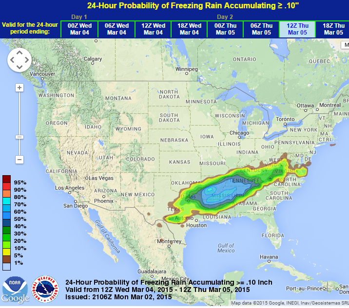
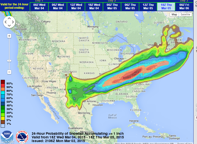
My bad, here's the 18z "snow" map to compare to the other one:
0 likes
#neversummer

Re: Texas Winter 2014-2015
dhweather wrote:If only the 18Z GFS were right........
16 day TOTAL PRECIP: 7.51 " and Convective: 2.37 "
That cat5 in the gulf from euro may be fantasy but the overall pattern is split flow (warm up) that may open the gulf up for rains. We'll see though, Im not sold yet on severe weather season.
0 likes
The above post and any post by Ntxw is NOT an official forecast and should not be used as such. It is just the opinion of the poster and may or may not be backed by sound meteorological data. It is NOT endorsed by any professional institution including Storm2k. For official information, please refer to NWS products.
Help support Storm2K!
-
Portastorm

- Storm2k Moderator

- Posts: 9954
- Age: 63
- Joined: Fri Jul 11, 2003 9:16 am
- Location: Round Rock, TX
- Contact:
Re: Texas Winter 2014-2015
It will be interesting to see if the 0z runs tonight keep the 18z trend of a drier post-frontal environment. As dhweather noted, the NAM has been pretty dry with its runs although notice the 12z run was wetter than the 6z and 18z runs. The GFS is trending drier from 12z to 18z but that's only one run.
We're all focusing on the surface features too and I honestly have not had time to compare the 500mb charts and find out WHY the 18z runs are drier from that perspective.
We're all focusing on the surface features too and I honestly have not had time to compare the 500mb charts and find out WHY the 18z runs are drier from that perspective.
0 likes
Any forecasts under my name are to be taken with a grain of salt. Get your best forecasts from the National Weather Service and National Hurricane Center.
Re: Texas Winter 2014-2015
Portastorm wrote:It will be interesting to see if the 0z runs tonight keep the 18z trend of a drier post-frontal environment. As dhweather noted, the NAM has been pretty dry with its runs although notice the 12z run was wetter than the 6z and 18z runs. The GFS is trending drier from 12z to 18z but that's only one run.
We're all focusing on the surface features too and I honestly have not had time to compare the 500mb charts and find out WHY the 18z runs are drier from that perspective.
The models have been going drier bc at 5h they drag the sw low and shear it slowly ala positive tilt trough which usually spells prefrontal rains that shuts off with CAA. Before when they had a bigger event they didnt shear it out as much.
0 likes
The above post and any post by Ntxw is NOT an official forecast and should not be used as such. It is just the opinion of the poster and may or may not be backed by sound meteorological data. It is NOT endorsed by any professional institution including Storm2k. For official information, please refer to NWS products.
Help support Storm2K!
Help support Storm2K!
-
Rgv20

- S2K Supporter
- Posts: 2466
- Age: 39
- Joined: Wed Jan 05, 2011 5:42 pm
- Location: Edinburg/McAllen Tx
NWS Brownsville afternoon discussion..
.LONG TERM.../WEDNESDAY THROUGH MONDAY/...HIGHLY ADVERTISED MAJOR COLD
FRONT STILL ON TAP FOR WEDNESDAY NIGHT INTO THURSDAY. SHARP
POSITIVELY TILTED TROUGH OVER THE WESTERN HALF THE U.S WITH A HIGHLY
AMPLIFIED RIDGE OFF THE WEST COAST TO SURGE ARCTIC AIR THROUGH
THE PLAINS AND INTO TEXAS. DEEP SOUTH TEXAS TO SEE THE FRONT
SHORTLY BEFORE OR AFTER MIDNIGHT WEDNESDAY WITH THE FRONT
CLEARING THE LOWER VALLEY BEFORE SUNRISE THURSDAY.
MODELS REMAIN IN GOOD AGREEMENT WITH THE FRONT TIMING AND STRENGTH
WITH COLD AIR BECOMING ENTRENCHED OVER THE REGION THUSDAY AND
FRIDAY WITH LITTLE RELIEF EXPECTED UNTIL NEXT SUNDAY. THE
NORTHERN AND SOUTHERN BRANCH OF THE JET STREAM INITIALLY PHASE
TOGETHER WEDNESDAY ALLOWING FOR THE ARCTIC AIR TO SURGE SOUTH. THE
NORTHERN BRANCH THEN LIFTS OUT NE WHILE ENERGY REMAINS ACROSS THE
DESERT SOUTHWEST AND OFF BAJA CA WITH THE SOUTHERN STREAM. ITS
THIS SOUTHERN STREAM ENERGY TAKE WILL DETERMINE OUR RAIN CHANCES
IN WAKE OF THE FRONT. A LOT OF UNCERTAINTY IN THE POPS WITH
GUIDANCE HOLDING ONTO GOOD TO LIKELY CHANCES BUT VERY LOW QPF. A
BLEND OF THE 12Z MODEL PACKAGE AND THE INHERITED FORECAST KEEP THE
BEST CHANCES IN THE MID AND LOWER VALLEY THROUGH MUCH OF THE
PERIOD.
AS FOR TEMPERATURES...THE BIG PLUNGE/FALL OF 30-45 DEGREES TAKES
PLACE ALL WITHIN A 9 TO 18 HOUR PERIOD THURSDAY MORNING. WIND
CHILLS WILL BE A FACTOR DROPPING BETWEEN 25 AND 35 DEGREES BY
THURSDAY SUNRISE...SUSTAINED WINDS OF 15 TO 30 MPH...AND NOT
RECOVERING UNTIL LATER FRIDAY. MODELS ARE DOING THEIR DARNEST
KEEPING TEMPERATURES RATHER LOW FRIDAY AND SATURDAY AND EVEN
SUNDAY WITH NO REAL SOUTHERLY RETURN FLOW EXPECTED. FUTURE
FORECAST MAY HAVE TO LOWER TEMPERATURES SOME MORE IF THE COLD AIR
DOES NOT MODIFY...VERY SIMILAR TO WHAT TOOK PLACE THIS PAST WEEKEND.
TOO EARLY AND HIGHLY UNCERTAIN IF ANY FREEZING PRECIPIATION DEVELOPS
OVER THE NORTHERN RANCHLANDS LATE THURSDAY NIGHT AND FRIDAY MORNING.
WET BULB ZERO TEMPERATURES APPROACHING FREEZING ON FORECAST
SOUNDINGS AND ATMOSPHERE INDICATES AN 8000 FOOT DEEP SATURATED LAYER.
THE LOW QPF SIGNAL WOULD SUGGEST FREEZING DRIZZLE AT BEST BUT AT
THIS TIME WILL KEEP LIQUID UNTIL WE GET CLOSER TO THE APPOINTED
TIME.
0 likes
The following post is NOT an official forecast and should not be used as such. It is just the opinion of the poster and may or may not be backed by sound meteorological data. It is NOT endorsed by any professional institution including storm2k.org For Official Information please refer to the NHC and NWS products.
-
Portastorm
- Storm2k Moderator
- Posts: 9954
- Age: 63
- Joined: Fri Jul 11, 2003 9:16 am
- Location: Round Rock, TX
- Contact:
Re: Texas Winter 2014-2015
Ntxw wrote:Portastorm wrote:It will be interesting to see if the 0z runs tonight keep the 18z trend of a drier post-frontal environment. As dhweather noted, the NAM has been pretty dry with its runs although notice the 12z run was wetter than the 6z and 18z runs. The GFS is trending drier from 12z to 18z but that's only one run.
We're all focusing on the surface features too and I honestly have not had time to compare the 500mb charts and find out WHY the 18z runs are drier from that perspective.
The models have been going drier bc at 5h they drag the sw low and shear it slowly ala positive tilt trough which usually spells prefrontal rains that shuts off with CAA. Before when they had a bigger event they didnt shear it out as much.
OK. Here's the thing ... I get why the NAM would be drier as, like I said, it has shown that 3 out of 4 runs. But the GFS being drier is a bit suspect as we know that the 6z and 18z GFS runs are not ingesting new data. So I'm a bit skeptical, especially with the SREF holding firm. But ... if the 0z runs all show the same thing, this could end up being a "sparkler" instead of a "grand finale."
I'm also eager to see the RGEM when the event comes into its wheelhouse.
0 likes
Any forecasts under my name are to be taken with a grain of salt. Get your best forecasts from the National Weather Service and National Hurricane Center.
Re: Texas Winter 2014-2015
Portastorm wrote:Ntxw wrote:Portastorm wrote:It will be interesting to see if the 0z runs tonight keep the 18z trend of a drier post-frontal environment. As dhweather noted, the NAM has been pretty dry with its runs although notice the 12z run was wetter than the 6z and 18z runs. The GFS is trending drier from 12z to 18z but that's only one run.
We're all focusing on the surface features too and I honestly have not had time to compare the 500mb charts and find out WHY the 18z runs are drier from that perspective.
The models have been going drier bc at 5h they drag the sw low and shear it slowly ala positive tilt trough which usually spells prefrontal rains that shuts off with CAA. Before when they had a bigger event they didnt shear it out as much.
OK. Here's the thing ... I get why the NAM would be drier as, like I said, it has shown that 3 out of 4 runs. But the GFS being drier is a bit suspect as we know that the 6z and 18z GFS runs are not ingesting new data. So I'm a bit skeptical, especially with the SREF holding firm. But ... if the 0z runs all show the same thing, this could end up being a "sparkler" instead of a "grand finale."
I'm also eager to see the RGEM when the event comes into its wheelhouse.
Its not that I'm pointing out the GFS is drier its that the overall model trend has been lessening with qpf and more so qpf below 32F. Doesn't mean its right it just means thats the overall movement they are doing, positive tilt. Not any particular run but en masse. We need to see some changes at 5h where the northern stream comes in behind the shortwave and the surface will work itself out. If not this will be an Arkansas points north and east.
0 likes
The above post and any post by Ntxw is NOT an official forecast and should not be used as such. It is just the opinion of the poster and may or may not be backed by sound meteorological data. It is NOT endorsed by any professional institution including Storm2k. For official information, please refer to NWS products.
Help support Storm2K!
Help support Storm2K!
-
Texas Snowman

- Storm2k Moderator
- Posts: 6197
- Joined: Fri Jan 25, 2008 11:29 am
- Location: Denison, Texas
Re: Texas Winter 2014-2015
Uh, Portastorm...hey buddy, you might want to take a look at what Larry Cosgrove just posted on his Facebook page:
https://scontent-sjc.xx.fbcdn.net/hphotos-xfa1/v/t1.0-9/11043078_10155329648435235_4317119034166050350_n.jpg?oh=66a084077971897b3b8b997143650b78&oe=55745A85
https://scontent-sjc.xx.fbcdn.net/hphotos-xfa1/v/t1.0-9/11043078_10155329648435235_4317119034166050350_n.jpg?oh=66a084077971897b3b8b997143650b78&oe=55745A85
0 likes
The above post and any post by Texas Snowman is NOT an official forecast and should not be used as such. It is just the opinion of the poster and may or may not be backed by sound meteorological data. It is NOT endorsed by any professional institution including storm2k.org. For official information, please refer to NWS products.
-
wxman57

- Moderator-Pro Met

- Posts: 23170
- Age: 68
- Joined: Sat Jun 21, 2003 8:06 pm
- Location: Houston, TX (southwest)
Re: Texas Winter 2014-2015
Texas Snowman wrote:Uh, Portastorm...hey buddy, you might want to take a look at what Larry Cosgrove just posted on his Facebook page:
https://scontent-sjc.xx.fbcdn.net/hphotos-xfa1/v/t1.0-9/11043078_10155329648435235_4317119034166050350_n.jpg?oh=66a084077971897b3b8b997143650b78&oe=55745A85
That says snow or thunderstorms or freezing rain/sleet somewhere between Texas & New England, not to include Austin.
0 likes
-
aggiecutter
- Category 5

- Posts: 1755
- Joined: Thu Oct 14, 2004 9:22 pm
- Location: Texarkana
Re: Texas Winter 2014-2015
The latest from the WPC suggest that Extreme NE Texas will receive a significant ice-snow event on Wednesday night:


0 likes

Re: Texas Winter 2014-2015
Since when is Cosgrove ever right anyways? I am leaning on the SREF. That graphic looks worse than a 7th grader's effort to make a forecast graphic. IJS. 
0 likes
This is not an official forecast, follow the NWS for official products!!!
-
Texas Snowman
- Storm2k Moderator
- Posts: 6197
- Joined: Fri Jan 25, 2008 11:29 am
- Location: Denison, Texas
Re: Texas Winter 2014-2015
wxman57 wrote:Texas Snowman wrote:Uh, Portastorm...hey buddy, you might want to take a look at what Larry Cosgrove just posted on his Facebook page:
https://scontent-sjc.xx.fbcdn.net/hphotos-xfa1/v/t1.0-9/11043078_10155329648435235_4317119034166050350_n.jpg?oh=66a084077971897b3b8b997143650b78&oe=55745A85
That says snow or thunderstorms or freezing rain/sleet somewhere between Texas & New England, not to include Austin.
Yeah, second glance, it is north of Austin. My apologies.
0 likes
The above post and any post by Texas Snowman is NOT an official forecast and should not be used as such. It is just the opinion of the poster and may or may not be backed by sound meteorological data. It is NOT endorsed by any professional institution including storm2k.org. For official information, please refer to NWS products.


Re: Texas Winter 2014-2015
wxman57 wrote:Texas Snowman wrote:Uh, Portastorm...hey buddy, you might want to take a look at what Larry Cosgrove just posted on his Facebook page:
https://scontent-sjc.xx.fbcdn.net/hphotos-xfa1/v/t1.0-9/11043078_10155329648435235_4317119034166050350_n.jpg?oh=66a084077971897b3b8b997143650b78&oe=55745A85
That says snow or thunderstorms or freezing rain/sleet somewhere between Texas & New England, not to include Austin.
To be fair, that is such a vague map...
0 likes
One year ago today we were tracking an infamous March blast. This was the hijinx blast that sent wxman57 scurrying for the love of cold weather. He predicted no more freezes beyond mid February but mother nature had other plans as Houston dipped below freezing and Teamplayersblue won the bet. Sleet fell at DFW and much north Texas, freezing drizzle/rain in central and southeast Texas. between 5-6pm DFW was sitting at 20F...heading for a low of 16F only 6 degrees shy of the all time record for the month. No official records were broken but they were all pretty dang close. One of the great singular March blasts since 1980.
Saved image (around 5pm)

Re-live his bipolar personality here
viewtopic.php?f=6&t=116197
Saved image (around 5pm)
Re-live his bipolar personality here
viewtopic.php?f=6&t=116197
Last edited by Ntxw on Mon Mar 02, 2015 8:37 pm, edited 1 time in total.
0 likes
The above post and any post by Ntxw is NOT an official forecast and should not be used as such. It is just the opinion of the poster and may or may not be backed by sound meteorological data. It is NOT endorsed by any professional institution including Storm2k. For official information, please refer to NWS products.
Help support Storm2K!
Help support Storm2K!
-
Texas Snowman
- Storm2k Moderator
- Posts: 6197
- Joined: Fri Jan 25, 2008 11:29 am
- Location: Denison, Texas
0 likes
The above post and any post by Texas Snowman is NOT an official forecast and should not be used as such. It is just the opinion of the poster and may or may not be backed by sound meteorological data. It is NOT endorsed by any professional institution including storm2k.org. For official information, please refer to NWS products.
-
Ralph's Weather
- S2K Supporter
- Posts: 3371
- Age: 38
- Joined: Fri Dec 13, 2013 11:55 am
- Location: Lindale, TX
- Contact:
Re:
I got will over two inches of thundersleet. Then the next morning it was 17 with light snow.Ntxw wrote:One year ago today we were tracking an infamous March blast. This was the hijinx blast that sent wxman57 scurrying for the love of cold weather. He predicted no more freezes beyond mid February but mother nature had other plans as Houston dipped below freezing and Teamplayersblue won the bet. Sleet fell at DFW and much north Texas, freezing drizzle/rain in central and southeast Texas. between 5-6pm DFW was sitting at 20F...heading for a low of 16F only 6 degrees shy of the all time record for the month. No official records were broken but they were all pretty dang close. One of the great singular March blasts since 1980.
Saved image (around 5pm)
http://i59.tinypic.com/sxy6gi.png
Re-live his bipolar personality here
viewtopic.php?f=6&t=116197
0 likes
Follow on Facebook at Ralph's Weather.
Re: Texas Winter 2014-2015
aggiecutter wrote:The latest from the WPC suggest that Extreme NE Texas will receive a significant ice-snow event on Wednesday night:
http://i269.photobucket.com/albums/jj79/Photo44_album/Untitled_zpsxxuhr6ev.png
http://i269.photobucket.com/albums/jj79/Photo44_album/Untitled1_zpssbulcqxb.png
I like that second map...
0 likes
Re: Texas Winter 2014-2015
Texas storm chasers about to livechat about Winter Storm here:
https://www.youtube.com/watch?v=AjlzFfIxzZc
https://www.youtube.com/watch?v=AjlzFfIxzZc
0 likes
-
TXdaddy217

- S2K Supporter
- Posts: 76
- Age: 55
- Joined: Sat Feb 21, 2015 4:40 pm
- Location: Abilene,TX
Re: Texas Winter 2014-2015
Latest statement from San Angelo/Abilene area.
SPECIAL WEATHER STATEMENT
NATIONAL WEATHER SERVICE SAN ANGELO TX
449 PM CST MON MAR 2 2015
TXZ049-054-064>066-071>073-076>078-098-099-113-114-127-128-139-
140-154-155-168>170-031300-
FISHER-NOLAN-STERLING-COKE-RUNNELS-IRION-TOM GREEN-CONCHO-
CROCKETT-SCHLEICHER-SUTTON-HASKELL-THROCKMORTON-JONES-SHACKELFORD-
TAYLOR-CALLAHAN-COLEMAN-BROWN-MCCULLOCH-SAN SABA-MENARD-KIMBLE-
MASON-
INCLUDING THE CITIES OF...ROTAN...ROBY...SWEETWATER...
STERLING CITY...ROBERT LEE...BRONTE...BALLINGER...WINTERS...
MERTZON...SAN ANGELO...EDEN...OZONA...ELDORADO...SONORA...
HASKELL...THROCKMORTON...WOODSON...STAMFORD...ANSON...HAMLIN...
ALBANY...ABILENE...CLYDE...BAIRD...CROSS PLAINS...COLEMAN...
BROWNWOOD...BRADY...SAN SABA...MENARD...JUNCTION...MASON
449 PM CST MON MAR 2 2015
...MORE WINTRY CONDITIONS ON THE WAY FOR WEDNESDAY AND THURSDAY...
WHAT YOU NEED TO KNOW.
1. FREEZING RAIN...SLEET...AND SNOW ARE EXPECTED TO DEVELOP ACROSS
THE INTERSTATE 20 CORRIDOR FROM SWEETWATER TO ABILENE AS EARLY AS
NOON ON WEDNESDAY...AND SPREAD SOUTH ACROSS THE REMAINDER OF WEST
CENTRAL TEXAS BY WEDNESDAY EVENING.
2. MUCH COLDER CONDITIONS EXPECTED AGAIN ON WEDNESDAY...WITH TEMPERATURES
FALLING THROUGH THE DAY. BY LATE AFTERNOON...READINGS WILL BE AT
OE BELOW FREEZING ALONG AND NORTH OF A SAN ANGELO TO BRADY LINE.
WIND CHILL READINGS WILL BE IN THE TEENS.
3. THERE IS HIGH CONFIDENCE IN THE ARRIVAL OF THE MUCH COLDER
CONDITIONS ONCE AGAIN. THERE IS LESS CONFIDENCE IN THE TYPE AND
AMOUNTS OF WINTRY PRECIPITATION...AND POTENTIAL IMPACTS.
HOWEVER...IT DOES APPEAR POSSIBLE THAT A LARGE PORTION OF WEST
CENTRAL TEXAS MAY SEE ENOUGH FREEZING RAIN...SLEET..OR SNOW TO
CREATE ANOTHER ROUND OF ICY ROAD CONDITIONS.
SUMMARY.
AFTER A MUCH WARMER DAY ON TUESDAY...ANOTHER VERY STRONG COLD
FRONT WILL MOVE THROUGH THE AREA ON WEDNESDAY. THIS FRONT WILL
COMBINE WITH A WEAK UPPER LEVEL STORM SYSTEM TO PRODUCE ANOTHER
ROUND OF WINTRY PRECIPITATION ACROSS MUCH OF WEST CENTRAL TEXAS.
AT THIS MOMENT...ITS A LITTLE EARLY TO TELL WHETHER THE
PRECIPITATION WILL END UP AS FREEZING RAIN...SLEET...SNOW...OR
SOME COMBINATION...AND THEREFORE EXACTLY WHAT THE POTENTIAL
IMPACTS WILL BE. RESIDENTS OF WEST CENTRAL TEXAS...AND ANYONE
WITH TRAVEL PLANS ACROSS THE AREA WEDNESDAY AND WEDNESDAY NIGHT
AND THURSDAY MORNING...SHOULD STAY ALERT FOR FUTURE UPDATES.
$$
0 likes
I am not a meteorologist. Anything posted by me should not be taken as an official forecast. Get your information from respected sources such as NWS and NOAA. I get my weather information the same way Hank Hill does ..... I look out the window and say ... "YUP".
Who is online
Users browsing this forum: 869MB, South Texas Storms and 84 guests