it looks like we could be getting into a MUCH colder pattern though IMO so anything
is likely game from early next week - the first, 2nd week of march likely active pattern setting up again...
Texas winter wx thread (2009-2010)
Moderator: S2k Moderators
Forum rules
 The posts in this forum are NOT official forecast and should not be used as such. They are just the opinion of the poster and may or may not be backed by sound meteorological data. They are NOT endorsed by any professional institution or STORM2K.

The posts in this forum are NOT official forecast and should not be used as such. They are just the opinion of the poster and may or may not be backed by sound meteorological data. They are NOT endorsed by any professional institution or STORM2K.

Our little storm becomes a classic monster nor'easter. Pretty to look at on the model. Looks like all out blizzard raging for the east coast 
0 likes
The above post and any post by Ntxw is NOT an official forecast and should not be used as such. It is just the opinion of the poster and may or may not be backed by sound meteorological data. It is NOT endorsed by any professional institution including Storm2k. For official information, please refer to NWS products.
Help support Storm2K!
-
Extremeweatherguy

- Category 5

- Posts: 11095
- Joined: Mon Oct 10, 2005 8:13 pm
- Location: Florida
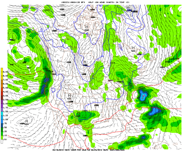
Here is a look at the last four runs of the GFS valid Tuesday afternoon:
18z = http://i43.photobucket.com/albums/e371/ ... 120l-2.gif
00z = http://i43.photobucket.com/albums/e371/ ... 114l-2.gif
06z = http://i43.photobucket.com/albums/e371/ ... 108l-1.gif
12z = http://i43.photobucket.com/albums/e371/ ... 102l-2.gif
There is definitely now some good consistency with this event on the GFS! The GFS continues to be inconsistent with the ECMWF and CMC though...which are a bit further north/weaker with the early week system. Overall, while the threat of a storm across the southern plains next week is definitely looking more likely, the exact details on timing, location and strength still need to be worked out.
0 likes
-
Weatherdude20
Re: Texas winter wx thread (2009-2010)
I agree Msstateguy83.
Based on what I am seeing now a good 3-6" is possible for Dallas and Fort Worth. These amounts could totally go higher(Or Lower). But as has been said quite a few times, trends are looking good for now, but, more consistency is needed, and as we approach the weekend and Sat-Sun., we will have a much better grasp on what we think will happen so more accurate forecasting will obviously come with time. Any Takers?
And I think the board wouldn't be as quiet this weekend as last
0 likes
-
wxman57

- Moderator-Pro Met

- Posts: 23170
- Age: 68
- Joined: Sat Jun 21, 2003 8:06 pm
- Location: Houston, TX (southwest)
Re: Texas winter wx thread (2009-2010)
I'm wondering if I plotted the wrong station on that meteogram I posted earlier for DFW airport area because it sure didn't show the amount of moisture across Dallas that I'm seeing elsewhere. Just went back and re-ran my request and still get less than 0.1" precip for DFW on the 06Z GFS run. Let me try 00Z... Hmm, 00Z had 0.6" of liquid for DFW. That's quite a difference. 06Z was much drier for Dallas area.
Anyway, I'll feel more confident when the Euro gets on board with the GFS, but I do agree that the chances of another significant snow event across Texas are increasing.
The 12Z GFS run seems in line with the 00Z GFS run. Maybe even a tad colder/wetter. Should be completed shortly. Perhaps the area of heaviest snow will be a bit south of last week's.
0 likes
-
msstateguy83
weatherdude i totally agree some might think my forecast have been 'reckless' in the past but its just i saw more consistency to me this setup is just about as good as me getting a dart board out rightnow and throwing darts at it (quite literley) i mean YES the stuff is there BUT this is winter weather, to be forecasting a MAJOR storm that far south almost at the end of feb when central tx does not hardly get that much anyways is almost reckless in my judgement... thats why iam holding out on this one to much in play at the moment but if you asked me do i see a major storm possibly taking hold next week i would tell you i think more likely then not BUT if you asked where i would think the odds of more heavy snow would be closer to dfw or west of there V.S. south towards waco, austin IMO... but i will post more in the coming days as the models get a better hold on this situation.
Last edited by msstateguy83 on Fri Feb 19, 2010 11:47 am, edited 1 time in total.
0 likes

Re: Texas winter wx thread (2009-2010)
When I saw the 0Z GFS this morning I did a double take. 6Z was a little drier as stated before but not so much for KTYR. Now after looking at the 12Z GFS starting to scratch my head. Could we really have two significant snows in one year, with in ten days of each other. Chating with the Shreveport Weather Service this morning they tell me it has happend once in their area, 1948.
Here is my latest write up on the potential with a few graphics if you like:
http://gdadeblog.blogspot.com/
Here is my latest write up on the potential with a few graphics if you like:
http://gdadeblog.blogspot.com/
0 likes
W. Grant Dade
Good Morning East Texas/Midday Meteorologist
KLTV 7 Tyler, TX
Good Morning East Texas/Midday Meteorologist
KLTV 7 Tyler, TX
What would the snow ratio's be wxman? I'm not sure if it's colder than the last event, but the freeze line sure is further south.
0 likes
The above post and any post by Ntxw is NOT an official forecast and should not be used as such. It is just the opinion of the poster and may or may not be backed by sound meteorological data. It is NOT endorsed by any professional institution including Storm2k. For official information, please refer to NWS products.
Help support Storm2K!
Help support Storm2K!
-
Portastorm

- Storm2k Moderator

- Posts: 9954
- Age: 63
- Joined: Fri Jul 11, 2003 9:16 am
- Location: Round Rock, TX
- Contact:
Re:
Ntxw wrote:What would the snow ratio's be wxman? I'm not sure if it's colder than the last event, but the freeze line sure is further south.
He said on another board that the air is colder than the DFW Snowmageddon ... it'll be Polar air and not shallow Arctic air. I'm guessing that would yield higher snow ratios.
0 likes
-
srainhoutx

- S2K Supporter

- Posts: 6919
- Age: 68
- Joined: Sun Jan 14, 2007 11:34 am
- Location: Haywood County, NC
- Contact:
Re: Texas winter wx thread (2009-2010)
wxman57 wrote:
Anyway, I'll feel more confident when the Euro gets on board with the GFS, but I do agree that the chances of another significant snow event across Texas are increasing.
The 12Z GFS run seems in line with the 00Z GFS run. Maybe even a tad colder/wetter. Should be completed shortly. Perhaps the area of heaviest snow will be a bit south of last week's.
I agree wxman57. If the ECMWF swings back and the UKMET follows, then I suspect many folks will wake up. Just don't plan that party too soon Portastorm. Please keep Lucy in check for now!
0 likes
Carla/Alicia/Jerry(In The Eye)/Michelle/Charley/Ivan/Dennis/Katrina/Rita/Wilma/Ike/Harvey
Member: National Weather Association
Wx Infinity Forums
http://wxinfinity.com/index.php
Facebook.com/WeatherInfinity
Twitter @WeatherInfinity
Member: National Weather Association
Wx Infinity Forums
http://wxinfinity.com/index.php
Facebook.com/WeatherInfinity
Twitter @WeatherInfinity
-
Portastorm
- Storm2k Moderator
- Posts: 9954
- Age: 63
- Joined: Fri Jul 11, 2003 9:16 am
- Location: Round Rock, TX
- Contact:
Re:
msstateguy83 wrote:weatherdude i totally agree some might think my forecast have been 'reckless' in the past but its just i saw more consistency to me this setup is just about as good as me getting a dart board out rightnow and throwing darts at it (quite literley) i mean YES the stuff is there BUT this is winter weather, to be forecasting a MAJOR storm that far south almost at the end of feb when central tx does not hardly get that much anyways is almost reckless in my judgement... thats why iam holding out on this one to much in play at the moment but if you asked me do i see a major storm possibly taking hold next week i would tell you i think more likely then not BUT if you asked where i would think the odds of more heavy snow would be closer to dfw or west of there V.S. south towards waco, austin IMO... but i will post more in the coming days as the models get a better hold on this situation.
BTW, it has happened before down here. Back in late February 2003, we had a two-day event with snow and sleet which accumulated to about three inches. The event included thundersleet! Only time I have seen that happen in my 26 years in Austin. It was a very vigorous upper-level storm system from what I remember. Anyhow, it shut down the town for two days.
0 likes
Re: Texas winter wx thread (2009-2010)
I like this graphic lol given it was the 0z, you could probably shift this a bit south and east but overall not too much diff with 12z. Colors!

0 likes
The above post and any post by Ntxw is NOT an official forecast and should not be used as such. It is just the opinion of the poster and may or may not be backed by sound meteorological data. It is NOT endorsed by any professional institution including Storm2k. For official information, please refer to NWS products.
Help support Storm2K!
Help support Storm2K!

Re: Texas winter wx thread (2009-2010)
DFW Snowmageddon 2?????
0 likes
just a guess.......take everything i say with a grain of salt.......check your local NWS for forecast information
Re: Texas winter wx thread (2009-2010)
katheria wrote::uarrow: nawww, like it but need to shift it a little east where the 10-12" area is smack over dfw heheeh
DFW Snowmageddon 2?????
Should wait for the NAM colors! (if there is). Better resolution, GFS is very coarse with precip amounts and temps.
0 likes
The above post and any post by Ntxw is NOT an official forecast and should not be used as such. It is just the opinion of the poster and may or may not be backed by sound meteorological data. It is NOT endorsed by any professional institution including Storm2k. For official information, please refer to NWS products.
Help support Storm2K!
Help support Storm2K!

-
wxman57
- Moderator-Pro Met
- Posts: 23170
- Age: 68
- Joined: Sat Jun 21, 2003 8:06 pm
- Location: Houston, TX (southwest)
Re: Texas winter wx thread (2009-2010)
Ok, 12Z all in. Meteogram still has 0.4" liquid equivalent for DFW area Tuesday, up from less than 0.1" at 06Z and down from the 0.6" at 00Z. We saw that with the last event, lots of variance from run to run as far as amounts.
http://myweb.cableone.net/nolasue/dfwgfs12zfeb19.gif
As for the sounding forecast, the GFS does forecast a mostly snow event again. Maybe a trace of rain at the start, but that's it. With 0.4" liquid, that could mean 2-4" snow. However, I suspect that we may see future runs bump the precip up a bit. Wouldn't be surprised if we saw a 4-8" event across Next Tuesday. Even more would be possible, but that would mean crawling way out on a limb.
12Z GFS Sounding Forecast (for those who can read them):
http://ready.arl.noaa.gov/readyout/3385 ... f_anim.gif
Have I mentioned that I'm really hating this winter lately?
Last edited by wxman57 on Fri Feb 19, 2010 12:01 pm, edited 1 time in total.
0 likes
-
Weatherdude20
Re: Texas winter wx thread (2009-2010)
wgdade wrote:When I saw the 0Z GFS this morning I did a double take. 6Z was a little drier as stated before but not so much for KTYR. Now after looking at the 12Z GFS starting to scratch my head. Could we really have two significant snows in one year, with in ten days of each other. Chating with the Shreveport Weather Service this morning they tell me it has happend once in their area, 1948.
Here is my latest write up on the potential with a few graphics if you like:
http://gdadeblog.blogspot.com/
Thank you for the update Grant.
0 likes

Re: Texas winter wx thread (2009-2010)
wxman57 wrote:I'm wondering if I plotted the wrong station on that meteogram I posted earlier for DFW airport area because it sure didn't show the amount of moisture across Dallas that I'm seeing elsewhere. Just went back and re-ran my request and still get less than 0.1" precip for DFW on the 06Z GFS run. Let me try 00Z... Hmm, 00Z had 0.6" of liquid for DFW. That's quite a difference. 06Z was much drier for Dallas area.
Anyway, I'll feel more confident when the Euro gets on board with the GFS, but I do agree that the chances of another significant snow event across Texas are increasing.
The 12Z GFS run seems in line with the 00Z GFS run. Maybe even a tad colder/wetter. Should be completed shortly. Perhaps the area of heaviest snow will be a bit south of last week's.
Yea waiting on the ECMWF...should be an interesting run.
0 likes
“If you thought that science was certain - well, that is just an error on your part.”
Re: Texas winter wx thread (2009-2010)
wxman57 wrote:Ok, 12Z all in. Meteogram still has 0.4" liquid equivalent for DFW area Tuesday, up from less than 0.1" at 06Z and down from the 0.6" at 00Z. We saw that with the last event, lots of variance from run to run as far as amounts.
http://myweb.cableone.net/nolasue/dfwgfs12zfeb19.gif
As for the sounding forecast, the GFS does forecast a mostly snow event again. Maybe a trace of rain at the start, but that's it. With 0.4" liquid, that could mean 2-4" snow. However, I suspect that we may see future runs bump the precip up a bit. Wouldn't be surprised if we saw a 4-8" event across Next Tuesday. Even more would be possible, but that would mean crawling way out on a limb.
12Z GFS Sounding Forecast (for those who can read them):
http://ready.arl.noaa.gov/readyout/3385 ... f_anim.gif
Have I mentioned that I'm really hating this winter lately?
With that from you, I'm officially on board. Same forecast 3-6" for DFW locally 6+ (the 6+ may actually be I-20 south this time, but as with last storm GFS can vary on amounts *going from an inch to 6+ for the metroplex with that one* but ended up along I-20 and just north). That record better be on it's heels right now...
The following post is NOT an official forecast and should not be used as such. It is just the opinion of the poster and may or may not be backed by sound meteorological data. It is NOT endorsed by any professional institution including storm2k.org. For official information, please refer to NWS products.
Last edited by Ntxw on Fri Feb 19, 2010 12:08 pm, edited 6 times in total.
0 likes
The above post and any post by Ntxw is NOT an official forecast and should not be used as such. It is just the opinion of the poster and may or may not be backed by sound meteorological data. It is NOT endorsed by any professional institution including Storm2k. For official information, please refer to NWS products.
Help support Storm2K!
Help support Storm2K!
-
Nederlander
- S2K Supporter
- Posts: 1259
- Joined: Sat Jul 19, 2008 4:28 pm
- Location: Conroe, TX
Re: Texas winter wx thread (2009-2010)
katheria wrote::uarrow: nawww, like it but need to shift it a little east where the 10-12" area is smack over dfw heheeh
DFW Snowmageddon 2?????
you guys have had your fair share in DFW.. time to share the wealth with the south...
0 likes