Texas winter wx thread (2009-2010)

Winter Weather Discussion

Moderator: S2k Moderators

Forum rules

The posts in this forum are NOT official forecast and should not be used as such. They are just the opinion of the poster and may or may not be backed by sound meteorological data. They are NOT endorsed by any professional institution or STORM2K.

Help Support Storm2K
Message
Author
User avatar
iorange55
Category 5
Category 5
Posts: 2388
Joined: Thu Nov 13, 2008 9:47 pm
Location: Big D

Re: Texas winter wx thread (2009-2010)

#7761 Postby iorange55 » Fri Feb 19, 2010 3:40 pm

WacoWx wrote:when does the next round of model data come in so I can quit checking here ever 30 seconds for updates?


NAM 18z is coming in now, and the GFS 18z will start in about an hour. Then the 0z's later tonight.
0 likes   

txwxwatcher
Tropical Depression
Tropical Depression
Posts: 98
Joined: Thu Feb 18, 2010 10:00 pm

Re: Texas winter wx thread (2009-2010)

#7762 Postby txwxwatcher » Fri Feb 19, 2010 3:44 pm

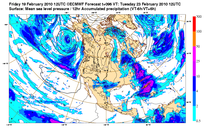
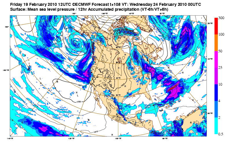
srainhoutx wrote:Also will add the the Free Site for the ECMWF offered a little bonus freebie today. Precip Maps...

Hour 96...

Image

Hour 108...

Image


Interesting. Correct me if I am wrong, but from my eye, according to this run from the better performing Euro, it looks like the heaviest precip may be making a move further south toward central and SE Texas. I am sure that would be welcomed by those in Austin and Houston who have missed out on major snow this season.
0 likes   

User avatar
srainhoutx
S2K Supporter
S2K Supporter
Posts: 6919
Age: 67
Joined: Sun Jan 14, 2007 11:34 am
Location: Haywood County, NC
Contact:

Re: Texas winter wx thread (2009-2010)

#7763 Postby srainhoutx » Fri Feb 19, 2010 3:57 pm

First hint of forecast changes from San Angelo...

.LONG TERM...

THE MODELS ARE IN BETTER AGREEMENT ON THE TIMING AND PATH OF THE
NEXT UPPER LEVEL LOW THAT THE LATEST WATER VAPOR IMAGERY SHOWS OFF
THE COAST OF SOUTHERN CALIFORNIA. THE STRONG UPPER LEVEL LOW WILL
QUICKLY MOVE EAST ACROSS SOUTHERN CALIFORNIA INTO SOUTHERN CONUS AND
THEN EAST ACROSS THE PANHANDLE OF TEXAS ON SUNDAY. STRONG
SOUTHERLY LOW LEVEL FLOW AHEAD OF THIS SYSTEM WILL ALLOW FOR GULF
MOISTURE TO MOVE INTO WEST CENTRAL TEXAS ON SATURDAY. INCREASED
POPS SLIGHTLY BUT STILL HAVE CHC TO LKLY POPS ACROSS WEST CENTRAL
TEXAS FOR SATURDAY OVERNIGHT INTO SUNDAY MORNING AS THUNDERSTORMS
ARE EXPECTED TO DEVELOP AHEAD OF A STRONG PACIFIC FRONT. THE
SHOWERS AND THUNDERSTORMS ARE EXPECTED TO MOVE QUICKLY ACROSS WEST
CENTRAL TEXAS AND SHOULD END BY LATE MORNING...EXCEPT ACROSS FAR
EASTERN PORTION OF WEST CENTRAL TEXAS WHERE SHOWERS AND
THUNDERSTORMS MAY LINGER INTO THE EARLY AFTERNOON.

A STRONG COLD FRONT IS STILL EXPECTED TO PUSH ACROSS WEST CENTRAL
TEXAS ON LATE SUNDAY INTO MONDAY. THE 12Z RUN OF THE GFS AND ECMWF
HAVE COME INTO BETTER AGREEMENT ON THE UPPER LEVEL PATTERN WITH
BOTH MODELS SHOWING AN UPPER LEVEL TROUGH APPROACHING WEST CENTRAL
TEXAS ON TUESDAY. THIS COMBINED WITH COLD AIR IN PLACE CREATES THE
POSSIBILITY OF WINTRY PRECIPITATION. THERE IS A GOOD CHANCE FOR
PRECIPITATION BUT TEMPERATURES STILL REMAIN UNCERTAIN. THE GFS
850MB TEMPERATURES REMAIN COLDER THAN THE ECMWF. THE 12Z GFS
SOUNDINGS FOR THE MOST PART HAVE SURFACE TEMPERATURES AND
DEWPOINTS HOVERING AROUND THE FREEZING MARK...EXCEPT ACROSS THE
BIG COUNTRY. ONCE AGAIN THIS IS A CASE WHERE A FEW DEGREES
DIFFERENCE IN TEMPERATURES CAN MEAN THE DIFFERENCE BETWEEN RAIN OR
SNOW FOR WEST CENTRAL TEXAS...SO WILL KEEP THE MENTION OF RAIN OR
SNOW IN THE WX GRIDS. THE MODELS ARE SHOWING QUITE A BIT OF QPF OF
TUESDAY INTO TUESDAY NIGHT...THIS COULD BECOME A CONCERN IF THE
PRECIPITATION FALLS AS SNOW. ATTM DUE TO THE UNCERTAINTY ON HOW
COLD TEMPERATURES WILL BE...WILL HOLD OFF ON PUTTING IN SNOWFALL
AMOUNTS.

FOR THE REMAINDER OF THE WORK WEEK THE MODELS HAVE DRY NORTHWEST
FLOW ALOFT ACROSS WEST CENTRAL TEXAS. TEMPERATURES WILL BE DEPENDENT
ON WHETHER OR NOT THERE IS SNOW ON THE GROUND.


0 likes   
Carla/Alicia/Jerry(In The Eye)/Michelle/Charley/Ivan/Dennis/Katrina/Rita/Wilma/Ike/Harvey

Member: National Weather Association
Wx Infinity Forums
http://wxinfinity.com/index.php

Facebook.com/WeatherInfinity
Twitter @WeatherInfinity

Storm Tracker SA-CS
Tropical Depression
Tropical Depression
Posts: 97
Joined: Fri Feb 19, 2010 2:01 pm
Location: College Station, TX

Re: Texas winter wx thread (2009-2010)

#7764 Postby Storm Tracker SA-CS » Fri Feb 19, 2010 3:59 pm

yes that would be amazing if san antonio to college station to houston all got in on the snow action this winter! from the last storm a few weeks ago, san antonio got no snow and college station got half an inch. i hope they both get over an inch from this storm!
0 likes   

User avatar
iorange55
Category 5
Category 5
Posts: 2388
Joined: Thu Nov 13, 2008 9:47 pm
Location: Big D

Re: Texas winter wx thread (2009-2010)

#7765 Postby iorange55 » Fri Feb 19, 2010 4:00 pm

2 inches to break the record, about. Come on snow.
0 likes   

User avatar
Ntxw
Storm2k Moderator
Storm2k Moderator
Posts: 22790
Joined: Wed Oct 21, 2009 6:34 pm
Location: DFW, Texas

Re: Texas winter wx thread (2009-2010)

#7766 Postby Ntxw » Fri Feb 19, 2010 4:01 pm

iorange55 wrote:2 inches to break the record, about. Come on snow.


Why settle for 2 when there's a chance to crack 20 inches for the season :wink: Would need 5-6 inches for that and set a new bar.

Actually I think it's 4.3 to crack 20.
Last edited by Ntxw on Fri Feb 19, 2010 4:03 pm, edited 1 time in total.
0 likes   
The above post and any post by Ntxw is NOT an official forecast and should not be used as such. It is just the opinion of the poster and may or may not be backed by sound meteorological data. It is NOT endorsed by any professional institution including Storm2k. For official information, please refer to NWS products.

  Help support Storm2K!
Help Support Storm2K

User avatar
iorange55
Category 5
Category 5
Posts: 2388
Joined: Thu Nov 13, 2008 9:47 pm
Location: Big D

Re: Texas winter wx thread (2009-2010)

#7767 Postby iorange55 » Fri Feb 19, 2010 4:03 pm

Ntxw wrote:
iorange55 wrote:2 inches to break the record, about. Come on snow.


Why settle for 2 when there's a chance to crack 20 inches for the season :wink: Would need 5-6 inches for that and set a new bar.


I am all for it. I need no convincing :]

Cheesy and gboudx on the other hand...... :wink:
0 likes   

Storm Tracker SA-CS
Tropical Depression
Tropical Depression
Posts: 97
Joined: Fri Feb 19, 2010 2:01 pm
Location: College Station, TX

Re: Texas winter wx thread (2009-2010)

#7768 Postby Storm Tracker SA-CS » Fri Feb 19, 2010 4:05 pm

how does the 18z nam look or does it not go out that far yet?
0 likes   

Weatherdude20

Re: Texas winter wx thread (2009-2010)

#7769 Postby Weatherdude20 » Fri Feb 19, 2010 4:06 pm

Ntxw wrote:
iorange55 wrote:2 inches to break the record, about. Come on snow.


Why settle for 2 when there's a chance to crack 20 inches for the season :wink: Would need 5-6 inches for that and set a new bar.

Actually I think it's 4.3 to crack 20.


I think we could make that with this next storm.
0 likes   

User avatar
Ntxw
Storm2k Moderator
Storm2k Moderator
Posts: 22790
Joined: Wed Oct 21, 2009 6:34 pm
Location: DFW, Texas

Re: Texas winter wx thread (2009-2010)

#7770 Postby Ntxw » Fri Feb 19, 2010 4:06 pm

Storm Tracker SA-CS wrote:how does the 18z nam look or does it not go out that far yet?


On par with the GFS for the time period it does go out to.
0 likes   
The above post and any post by Ntxw is NOT an official forecast and should not be used as such. It is just the opinion of the poster and may or may not be backed by sound meteorological data. It is NOT endorsed by any professional institution including Storm2k. For official information, please refer to NWS products.


  Help support Storm2K!

Help Support Storm2K


Storm Tracker SA-CS
Tropical Depression
Tropical Depression
Posts: 97
Joined: Fri Feb 19, 2010 2:01 pm
Location: College Station, TX

Re: Texas winter wx thread (2009-2010)

#7771 Postby Storm Tracker SA-CS » Fri Feb 19, 2010 4:08 pm

Ntxw how much do you think we will get here in college station based on what you see in the models right now?
0 likes   

User avatar
Ntxw
Storm2k Moderator
Storm2k Moderator
Posts: 22790
Joined: Wed Oct 21, 2009 6:34 pm
Location: DFW, Texas

Re: Texas winter wx thread (2009-2010)

#7772 Postby Ntxw » Fri Feb 19, 2010 4:10 pm

Storm Tracker SA-CS wrote:Ntxw how much do you think we will get here in college station based on what you see in the models right now?


I'm really weary to say accumulated snow south of I-20 for any given storm on any given day, BUT! there's a decent chance of 1-2 inches maybe more as of right now down that way from what the models show =D if you go back a few pages, people have posted snow maps from the GFS which if you can find your area that would be a good place to look.

From wxman

wxman57 wrote:12z snow accumulation graphics are in here:

http://wxcaster.com/gis-gfs-snow-overlays.htm

Here's one for NE TX. Note 3-4" DFW area and up to 8-10" just NE of Brownwood. Hey! Even 1-2" for portastorm!
Image
0 likes   
The above post and any post by Ntxw is NOT an official forecast and should not be used as such. It is just the opinion of the poster and may or may not be backed by sound meteorological data. It is NOT endorsed by any professional institution including Storm2k. For official information, please refer to NWS products.


  Help support Storm2K!

Help Support Storm2K


Storm Tracker SA-CS
Tropical Depression
Tropical Depression
Posts: 97
Joined: Fri Feb 19, 2010 2:01 pm
Location: College Station, TX

Re: Texas winter wx thread (2009-2010)

#7773 Postby Storm Tracker SA-CS » Fri Feb 19, 2010 4:13 pm

oh ok thanks! i hope you're right! :)
0 likes   

User avatar
Portastorm
Storm2k Moderator
Storm2k Moderator
Posts: 9914
Age: 63
Joined: Fri Jul 11, 2003 9:16 am
Location: Round Rock, TX
Contact:

Re: Texas winter wx thread (2009-2010)

#7774 Postby Portastorm » Fri Feb 19, 2010 4:14 pm

Some very interesting AFDs coming out of the Texas offices this afternoon. :cheesy:
0 likes   

User avatar
iorange55
Category 5
Category 5
Posts: 2388
Joined: Thu Nov 13, 2008 9:47 pm
Location: Big D

Re: Texas winter wx thread (2009-2010)

#7775 Postby iorange55 » Fri Feb 19, 2010 4:14 pm

DFW NWS

THE FORECAST GETS A LITTLE MORE INTERESTING MONDAY NIGHT AND
TUESDAY. THE LATEST RUN OF THE GFS AND THE ECMWF ARE NOW BOTH
SHOWING ANOTHER DEVELOPING LOW PRESSURE SYSTEM NEAR THE FOUR
CORNERS REGION. ENERGY AND MOISTURE ASSOCIATED WITH THIS SYSTEM
SHOULD BRING ANOTHER CHANCE OF PRECIPITATION LATE MONDAY NIGHT AND
TUESDAY. TEMPERATURE PROFILES FROM BOTH MODELS INDICATE THAT ANY
PRECIPITATION WOULD FALL AS SNOW. OF COURSE...THIS SYSTEM IS
SEVERAL DAYS OUT SO MANY THINGS COULD CHANGE...BUT THERE WILL BE
A POTENTIAL FOR ACCUMULATING SNOW IF THE PROGS ARE CORRECT. AS
CURRENTLY DEPICTED...THIS SYSTEM WOULD HAVE LESS MOISTURE THAN THE
LAST SYSTEM THAT BROUGHT SNOW TO NORTH TEXAS AND WOULD BE FASTER
MOVING. HOWEVER...THE EXPECTED SURFACE TEMPERATURES WOULD BE
COLDER WHICH COULD RESULT IN FASTER ACCUMULATION OF ROADS. WE
WILL ISSUE A SPECIAL WEATHER STATEMENT OUTLINING THIS POSSIBLE
SNOW EVENT.

THE UPPER TROUGH SHOULD EXIT THE REGION TUESDAY NIGHT AS AN UPPER
LEVEL RIDGE BUILDS IN FROM THE WEST. THIS PATTERN SHOULD KEEP
NORTH TEXAS DRY FROM MID WEEK THROUGH THE WEEKEND.

0 likes   

WacoWx
Category 2
Category 2
Posts: 664
Joined: Mon Dec 28, 2009 4:14 pm
Location: NOT Waco, TX ----> Dallas, TX

Re: Texas winter wx thread (2009-2010)

#7776 Postby WacoWx » Fri Feb 19, 2010 4:17 pm

Special Weather Statement Ft Worth:

THUNDERSTORMS SUNDAY FOLLOWED BY POSSIBLE WINTER WEATHER ON TUESDAY...

SHOWERS AND THUNDERSTORMS ARE EXPECTED SATURDAY NIGHT AND INTO
SUNDAY AS A SURFACE LOW PRESSURE SYSTEM DEVELOPS AND MOVES THROUGH
THE AREA. ISOLATED STRONG TO SEVERE STORMS ARE POSSIBLE EAST OF
INTERSTATE 35...WITH THE MAIN THREAT BEING LARGE HAIL. PRECIPITATION
WILL END FROM WEST TO EAST SUNDAY AFTERNOON.

AS THE SURFACE LOW EXITS THE REGION...A COLD FRONT WILL ADVANCE
ACROSS THE REGION MONDAY...DROPPING TEMPERATURES INTO THE 30S.
ANOTHER DISTURBANCE WILL MOVE THROUGH ON TUESDAY AND WITH THE COLD
AIR ALREADY IN PLACE...WINTER PRECIPITATION IS POSSIBLE. GIVEN
THE UNCERTAINTY OF THE TRACK AND STRENGTH OF THE DISTURBANCE...WE
WILL CONTINUE TO ASSESS FUTURE DATA AND UPDATE THE FORECAST AS
MORE INFORMATION BECOMES AVAILABLE.

NORTH TEXAS RESIDENTS AND MOTORISTS TRAVELING ACROSS THE REGION
ON TUESDAY SHOULD STAY INFORMED OF THE LATEST WEATHER INFORMATION
AND FORECASTS BY VISITING OUR WEBSITE AT http://WWW.WEATHER.GOV/FORTWORT
0 likes   

Storm Tracker SA-CS
Tropical Depression
Tropical Depression
Posts: 97
Joined: Fri Feb 19, 2010 2:01 pm
Location: College Station, TX

Re: Texas winter wx thread (2009-2010)

#7777 Postby Storm Tracker SA-CS » Fri Feb 19, 2010 4:19 pm

HGX AFD

AS FOR THE EXTENDED FCST 12Z GUIDANCE LOOKS TO BE COMING TOGETHER
TO MORE OF A CONSENSUS...BUT CONFIDENCE REMAINS VERY LOW WITH THE
EVENTUAL OUTCOME. AS IT STANDS NOW THE TRENDS POINT TO A SYNOPTIC
SCALE PATTERN WHERE A SLOWLY DEEPENING UPPER TROF (DEVELOPING AOA
THE LEE OF THE ROCKIES) PUSHES ACROSS THE SRN PLAINS BY MID WEEK.
GFS HAS BEEN THE MOST CONSISTENT OF THE BUNCH WITH THIS SCENARIO/
SOLN BUT IT HAS ALSO BEEN THE MOST INSISTENT WITH THE IDEA OF -SN
AND/OR IP FOR OUR CWFA. ECMWF REMAINS ON THE WARMER/DRIER SIDE SO
FAR. AND SO HAVING SAID ALL THAT WILL ALSO OPT FOR THE DISCRETION
AS THE BETTER PART OF VALOR CARD FOR THE LONG RANGE FCST AND KEEP
THE GRIDS AS IS FOR NOW. HOPEFULLY THESE NEXT FEW MODEL RUNS WILL
SHED A BIT MORE LIGHT/CLARITY ON THIS. 41
0 likes   

txwxwatcher
Tropical Depression
Tropical Depression
Posts: 98
Joined: Thu Feb 18, 2010 10:00 pm

#7778 Postby txwxwatcher » Fri Feb 19, 2010 4:20 pm

I would just be careful about making too much out of the projections at this point. As others have alluded to, the timing, location, precip-type, and amounts will be greatly influenced by where along the west coast the low makes landfall. Yesterday it was projected to make landfall as far north as the California/Oregon border, but today it is projected to move onshore closer to the San Diego area. That is quite a divergent forecast in a 24-hour time span.
0 likes   

User avatar
jasons2k
Storm2k Executive
Storm2k Executive
Posts: 8245
Age: 51
Joined: Wed Jul 06, 2005 12:32 pm
Location: The Woodlands, TX

Re: Texas winter wx thread (2009-2010)

#7779 Postby jasons2k » Fri Feb 19, 2010 4:20 pm

THE EXPECTED SURFACE TEMPERATURES WOULD BE
COLDER WHICH COULD RESULT IN FASTER ACCUMULATION OF ROADS.


Does that mean TxDOT will finally solve our traffic gridlock? hehe.
0 likes   

User avatar
Ntxw
Storm2k Moderator
Storm2k Moderator
Posts: 22790
Joined: Wed Oct 21, 2009 6:34 pm
Location: DFW, Texas

Re:

#7780 Postby Ntxw » Fri Feb 19, 2010 4:25 pm

txwxwatcher wrote:I would just be careful about making too much out of the projections at this point. As others have alluded to, the timing, location, precip-type, and amounts will be greatly influenced by where along the west coast the low makes landfall. Yesterday it was projected to make landfall as far north as the California/Oregon border, but today it is projected to move onshore closer to the San Diego area. That is quite a divergent forecast in a 24-hour time span.


As Wxman said, nothing is certain, but you can certainly make a forecast 3-4 days out especially when the models have begun to diverge/agree on a solution as they did today. That's a big hint that things are getting clearer.
0 likes   
The above post and any post by Ntxw is NOT an official forecast and should not be used as such. It is just the opinion of the poster and may or may not be backed by sound meteorological data. It is NOT endorsed by any professional institution including Storm2k. For official information, please refer to NWS products.


  Help support Storm2K!

Help Support Storm2K


Return to “Winter Weather”

Who is online

Users browsing this forum: No registered users and 442 guests