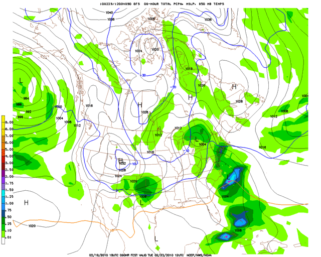
12z vs. 18z GFS 850mb temps & precip. for Tuesday morning:
12z = http://i43.photobucket.com/albums/e371/ ... p_096l.gif
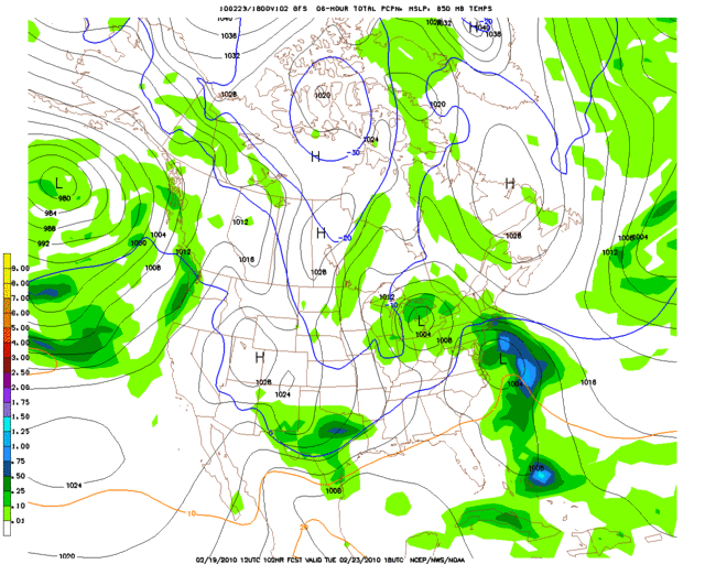
18z = http://i43.photobucket.com/albums/e371/ ... p_090l.gif
And Tuesday afternoon:
12z = http://i43.photobucket.com/albums/e371/ ... p_102l.gif
18z = http://i43.photobucket.com/albums/e371/ ... 096l-1.gif
Texas winter wx thread (2009-2010)
Moderator: S2k Moderators
Forum rules
 The posts in this forum are NOT official forecast and should not be used as such. They are just the opinion of the poster and may or may not be backed by sound meteorological data. They are NOT endorsed by any professional institution or STORM2K.

The posts in this forum are NOT official forecast and should not be used as such. They are just the opinion of the poster and may or may not be backed by sound meteorological data. They are NOT endorsed by any professional institution or STORM2K.
-
Extremeweatherguy

- Category 5

- Posts: 11095
- Joined: Mon Oct 10, 2005 8:13 pm
- Location: Florida
Re: Texas winter wx thread (2009-2010)
Last edited by Extremeweatherguy on Fri Feb 19, 2010 5:09 pm, edited 1 time in total.
0 likes

Still a pretty good consensus by the GFS someone along I-20 will get clocked. And again, southern Oklahoma in game again.
Last edited by Ntxw on Fri Feb 19, 2010 5:09 pm, edited 1 time in total.
0 likes
The above post and any post by Ntxw is NOT an official forecast and should not be used as such. It is just the opinion of the poster and may or may not be backed by sound meteorological data. It is NOT endorsed by any professional institution including Storm2k. For official information, please refer to NWS products.
Help support Storm2K!
-
Nederlander
- S2K Supporter

- Posts: 1259
- Joined: Sat Jul 19, 2008 4:28 pm
- Location: Conroe, TX
Re: Texas winter wx thread (2009-2010)
Storm Tracker SA-CS wrote:ahhhh 18z is not looking good for us here in college station....
Just like hurricane models, theres no need to worry about one particular run.. the important thing is that we are finally seeing some consistency.. there will be minor changes each run.. especially temperatures.. it is a tad warmer, but no reason to panic if you are wanting wintry precip.. CS is still in a reasonably good spot to see something I think..
0 likes
-
Extremeweatherguy
- Category 5
- Posts: 11095
- Joined: Mon Oct 10, 2005 8:13 pm
- Location: Florida
-
DFW Stormwatcher
- Tropical Storm

- Posts: 243
- Age: 55
- Joined: Sun Dec 27, 2009 10:35 pm
- Location: Keller, Tx
Re:
txagwxman wrote:18z is a little warmer---maybe it will be an all rain event...since I won't get any down here.
Thats just evil wxman
Last edited by DFW Stormwatcher on Fri Feb 19, 2010 5:25 pm, edited 1 time in total.
0 likes
Disclaimer: This is not an official weather forecast. I am only an amateur weather enthusiast therefore any weather forecasts or opinions should be taken with a grain of salt. Hook em Horns!
-
msstateguy83
i know some disagree w/my earlyer statements on the systems track BUT just looking
at the 18z i see atleast more light snow further north up into central ok... rightnow iam saying from dfw, points nw of i-20 BUT this could even become something close to christmas eve and setup near i-44 in far north tx up into oklahoma just needs to be watched closely as we head into the weekend as we get more data in on it...
at the 18z i see atleast more light snow further north up into central ok... rightnow iam saying from dfw, points nw of i-20 BUT this could even become something close to christmas eve and setup near i-44 in far north tx up into oklahoma just needs to be watched closely as we head into the weekend as we get more data in on it...
0 likes
The set up is almost eerily similar to last Thursday, from what I can see msstateguy83. It's freakish how everything is almost the exact same. You have a storm blossoming and exiting the northeast (currently poised to cross the southern plains in the exact same track even for that storm) with a PV holding up north providing the blocking, bringing down the cold air to set up for the storm pulling itself together off California. It then moves in the exact same way transferring energy off into the gulf coast once it passes Texas. I do hope this storm has a lot more cold air to work with for friends down south.
Last edited by Ntxw on Fri Feb 19, 2010 5:35 pm, edited 2 times in total.
0 likes
The above post and any post by Ntxw is NOT an official forecast and should not be used as such. It is just the opinion of the poster and may or may not be backed by sound meteorological data. It is NOT endorsed by any professional institution including Storm2k. For official information, please refer to NWS products.
Help support Storm2K!
Help support Storm2K!
-
Extremeweatherguy
- Category 5
- Posts: 11095
- Joined: Mon Oct 10, 2005 8:13 pm
- Location: Florida
Re: Re:
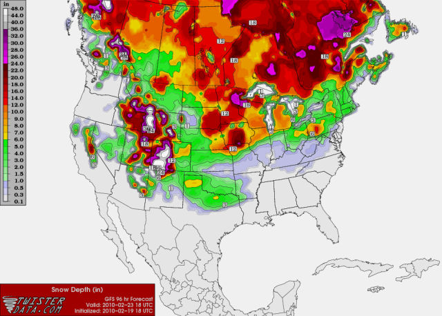
That image is a model estimate of how much snow the model expects to be on the ground at that point. It is not really a total accumulation map though, because it does take into account some of the impacts of melting.gboudx wrote:Extremeweatherguy wrote:18z GFS snow depth map for Tuesday afternoon:
So, that map shows total accumulation to that point in the forecast period right?
Last edited by Extremeweatherguy on Fri Feb 19, 2010 5:37 pm, edited 2 times in total.
0 likes
-
Nederlander
- S2K Supporter
- Posts: 1259
- Joined: Sat Jul 19, 2008 4:28 pm
- Location: Conroe, TX
Re: Texas winter wx thread (2009-2010)
i wasnt all that upset until i saw that snow depth map.. thats just disgusting compared to the previous.. still not sold on another I-20 direct strike though
0 likes
-
southerngale

- Retired Staff

- Posts: 27418
- Joined: Thu Oct 10, 2002 1:27 am
- Location: Southeast Texas (Beaumont area)
Re:
Extremeweatherguy wrote:18z GFS snow depth map for Tuesday afternoon:
Ouch. MUCH further north in this map. The last one even had my tiny little corner of SE TX getting a little snow.
It is the 18z though. Full panic mode should be abolished at once, at least until the 0z comes out.

0 likes
Please support Storm2k by making a donation today. It is greatly appreciated! Click here: 
 my Cowboys my Rockets my Astros
my Cowboys my Rockets my Astros-
WacoWx
- Category 2

- Posts: 692
- Joined: Mon Dec 28, 2009 4:14 pm
- Location: NOT Waco, TX ----> Dallas, TX
Re: Texas winter wx thread (2009-2010)
...^^^shows cold and wet up until a day or 2 before, warms up a hair and dries out, and then gets back in line with its previous trends and explodes. for yalls sake, i hope so.
0 likes
-
Portastorm

- Storm2k Moderator

- Posts: 9954
- Age: 63
- Joined: Fri Jul 11, 2003 9:16 am
- Location: Round Rock, TX
- Contact:
Re: Texas winter wx thread (2009-2010)
Nederlander wrote:i wasnt all that upset until i saw that snow depth map.. thats just disgusting compared to the previous.. still not sold on another I-20 direct strike though
Don't get too worked up Nederlander. It's the 18z GFS for Pete's sake ... not exactly a benchmark for accuracy. And it's just one run.
At this point, all we know is its likely someone in Texas is going to get a nice snowstorm next week. Some will build snowmen, some will build cold rain men.
0 likes
-
setxweatherfreak

- Tropical Low

- Posts: 22
- Joined: Tue Feb 09, 2010 5:42 pm
- Location: Orange, TX
Re:
southerngale wrote:Oh, hmmm. Just saw this in my forecast. Yeah, riiiight.
Tuesday: A 50 percent chance of rain. Mostly cloudy, with a high near 54. North wind between 10 and 15 mph.
Tuesday Night: Rain and snow likely. Mostly cloudy, with a low around 34. North wind between 10 and 15 mph. Chance of precipitation is 60%.
But the AFD mentions the mix is possible in the piney woods and lakes region. I don't live up there.Oh well, we'll see. Here goes the yo-yo again.
Edit: I live just a few miles outside of Beaumont, off Hwy. 105. This is Beaumont's forecast for that timeframe:
Tuesday: Mostly sunny, with a high near 54. Northeast wind around 5 mph.
Tuesday Night: Partly cloudy, with a low around 39.

What the heck? The forecasts are sometimes different, but not that much. 50% rain & 60% rain/snow vs sunny & partly cloudy with just a few miles difference. That ain't right!
Yeah - I'm from Orange - so does that mean we have either a 60% snow chance or just partly sunny skies?? LOL
0 likes
-
Nederlander
- S2K Supporter
- Posts: 1259
- Joined: Sat Jul 19, 2008 4:28 pm
- Location: Conroe, TX
Re: Texas winter wx thread (2009-2010)
Portastorm wrote:Nederlander wrote:i wasnt all that upset until i saw that snow depth map.. thats just disgusting compared to the previous.. still not sold on another I-20 direct strike though
Don't get too worked up Nederlander. It's the 18z GFS for Pete's sake ... not exactly a benchmark for accuracy. And it's just one run.
At this point, all we know is its likely someone in Texas is going to get a nice snowstorm next week. Some will build snowmen, some will build cold rain men.
yeah im definitely not in panic mode yet.. need to see the new data in the 0z run to get a better handle on whats unfolding.. I wont be all that upset if we dont get snow down here.. but I will be one ticked individual if its low-mid 30's and pouring rain.. therefore if thats the case, i would rather this thing just go away and have warmer weather.. i wont feel sorry for DFW if they dont get more snow..
Last edited by Nederlander on Fri Feb 19, 2010 5:42 pm, edited 1 time in total.
0 likes

Re: Texas winter wx thread (2009-2010)
Lol, geez. This place is vicious. Poor people here in Dallas, where is the love y'all?

0 likes
I know  We got burned last year compared to everyone else (except for Portastorm). It is just one run afterall 18z at that. It doesn't look much different than previous runs except there is warmer air. I figure GFS will trend colder as we get closer to the event.
0 likes
The above post and any post by Ntxw is NOT an official forecast and should not be used as such. It is just the opinion of the poster and may or may not be backed by sound meteorological data. It is NOT endorsed by any professional institution including Storm2k. For official information, please refer to NWS products.
Help support Storm2K!
Help support Storm2K!
-
Nederlander
- S2K Supporter
- Posts: 1259
- Joined: Sat Jul 19, 2008 4:28 pm
- Location: Conroe, TX
Re: Texas winter wx thread (2009-2010)
iorange55 wrote:Lol, geez. This place is vicious. Poor people here in Dallas, where is the love y'all?
dont misunderstand me.. im glad you guys have been able to witness an historic winter and all the snow you guys have had.. im just saying that it supremely sucks when its 33 degrees outside and pouring rain for hours on end.. thats why i said i would rather have the warm weather even if it means sacrificing snow for dallas.. hey dont be greedy.. if there was a way we could have 70 degree weather down here and a blizzard in dallas... then im all for it
0 likes
-
southerngale
- Retired Staff
- Posts: 27418
- Joined: Thu Oct 10, 2002 1:27 am
- Location: Southeast Texas (Beaumont area)
Re: Re:
setxweatherfreak wrote:southerngale wrote:Oh, hmmm. Just saw this in my forecast. Yeah, riiiight.
Tuesday: A 50 percent chance of rain. Mostly cloudy, with a high near 54. North wind between 10 and 15 mph.
Tuesday Night: Rain and snow likely. Mostly cloudy, with a low around 34. North wind between 10 and 15 mph. Chance of precipitation is 60%.
But the AFD mentions the mix is possible in the piney woods and lakes region. I don't live up there.
Edit: I live just a few miles outside of Beaumont, off Hwy. 105. This is Beaumont's forecast for that timeframe:
Tuesday: Mostly sunny, with a high near 54. Northeast wind around 5 mph.
Tuesday Night: Partly cloudy, with a low around 39.
What the heck? The forecasts are sometimes different, but not that much. 50% rain & 60% rain/snow vs sunny & partly cloudy with just a few miles difference. That ain't right!
Yeah - I'm from Orange - so does that mean we have either a 60% snow chance or just partly sunny skies?? LOL
Sorry, I should have specified. I'm along Hwy.105, just west of Beaumont, but LOL... I still get your point.
FWIW, your forecast is much like Beaumont's. I'm only a few miles outside Bmt. city limits, but I'm sure I'm just getting lumped into the forecasts for folks north of here.
Btw, you ought to put Orange, Tx. in your profile for your location. When you're talking about your weather, people will know where in SE TX you are.
0 likes
Please support Storm2k by making a donation today. It is greatly appreciated! Click here:
my Cowboys my Rockets my Astros
my Cowboys my Rockets my AstrosWho is online
Users browsing this forum: AnnularCane, Brent, South Texas Storms and 64 guests