Texas winter wx thread (2009-2010)

Winter Weather Discussion

Moderator: S2k Moderators

Forum rules

The posts in this forum are NOT official forecast and should not be used as such. They are just the opinion of the poster and may or may not be backed by sound meteorological data. They are NOT endorsed by any professional institution or STORM2K.

Help Support Storm2K
Message
Author
User avatar
setxweatherfreak
Tropical Low
Tropical Low
Posts: 22
Joined: Tue Feb 09, 2010 5:42 pm
Location: Orange, TX

Re: Re:

#7821 Postby setxweatherfreak » Fri Feb 19, 2010 5:54 pm

What the heck? The forecasts are sometimes different, but not that much. 50% rain & 60% rain/snow vs sunny & partly cloudy with just a few miles difference. That ain't right![/quote]


Yeah - I'm from Orange - so does that mean we have either a 60% snow chance or just partly sunny skies?? LOL[/quote]

Sorry, I should have specified. I'm along Hwy.105, just west of Beaumont, but LOL... I still get your point.

FWIW, your forecast is much like Beaumont's. I'm only a few miles outside Bmt. city limits, but I'm sure I'm just getting lumped into the forecasts for folks north of here.

Btw, you ought to put Orange, Tx. in your profile for your location. When you're talking about your weather, people will know where in SE TX you are.[/quote]

AH ha - Ok...got it :wink:
0 likes   

WacoWx
Category 2
Category 2
Posts: 664
Joined: Mon Dec 28, 2009 4:14 pm
Location: NOT Waco, TX ----> Dallas, TX

Re: Texas winter wx thread (2009-2010)

#7822 Postby WacoWx » Fri Feb 19, 2010 5:57 pm

When I come back Monday, I'll be hoping for 6-8 in forecast here in Waco by msstateguy and a foot by everyone else. Portastorm gets 13'' and 4 ft drifts. :lol: Have a good weekend all!
0 likes   

User avatar
srainhoutx
S2K Supporter
S2K Supporter
Posts: 6919
Age: 67
Joined: Sun Jan 14, 2007 11:34 am
Location: Haywood County, NC
Contact:

Re: Texas winter wx thread (2009-2010)

#7823 Postby srainhoutx » Fri Feb 19, 2010 5:59 pm

FYI: There will be one more G-IV RECON mission tomorrow at 12Z. No C-130 missions scheduled from Anchorage...

000
NOUS42 KNHC 191700
WEATHER RECONNAISSANCE FLIGHTS
CARCAH, NATIONAL HURRICANE CENTER, MIAMI, FL.
1200 PM EST FRI 19 FEBRUARY 2010
SUBJECT: WINTER STORM PLAN OF THE DAY (WSPOD)
VALID 20/1100Z TO 21/1100Z FEBRUARY 2010
WSPOD NUMBER.....09-081

I. ATLANTIC REQUIREMENTS
1. NEGATIVE RECONNAISSANCE REQUIREMENTS.
2. SUCCEEDING DAY OUTLOOK.....NEGATIVE.

II. PACIFIC REQUIREMENTS
1. NEGATIVE RECONNAISSANCE REQUIREMENTS.
2. OUTLOOK FOR SUCCEEDING DAY.....NEGATIVE.
3. REMARKS: G-IV MISSION FOR 20/1200Z WILL
FLY AS PREVIOUSLY SCHEDULED.

JWP
0 likes   
Carla/Alicia/Jerry(In The Eye)/Michelle/Charley/Ivan/Dennis/Katrina/Rita/Wilma/Ike/Harvey

Member: National Weather Association
Wx Infinity Forums
http://wxinfinity.com/index.php

Facebook.com/WeatherInfinity
Twitter @WeatherInfinity

User avatar
wxman57
Moderator-Pro Met
Moderator-Pro Met
Posts: 22984
Age: 67
Joined: Sat Jun 21, 2003 8:06 pm
Location: Houston, TX (southwest)

Re: Texas winter wx thread (2009-2010)

#7824 Postby wxman57 » Fri Feb 19, 2010 6:02 pm

Storm Tracker SA-CS wrote:wxman57, how do you feel about the houston area's snow chances?


I wouldn't put snow in a forecast now (meaning most likely to occur), but I would mention cold rain mixed with sleet as a possibility. I don't see this being an accumulating snow event for us.
0 likes   

User avatar
srainhoutx
S2K Supporter
S2K Supporter
Posts: 6919
Age: 67
Joined: Sun Jan 14, 2007 11:34 am
Location: Haywood County, NC
Contact:

Re: Texas winter wx thread (2009-2010)

#7825 Postby srainhoutx » Fri Feb 19, 2010 6:14 pm

FYI: HPC Updated the Final Extended again for what it is worth...

EXTENDED FORECAST DISCUSSION
NWS HYDROMETEOROLOGICAL PREDICTION CENTER CAMP SPRINGS MD
251 PM EST FRI FEB 19 2010

VALID 12Z MON FEB 22 2010 - 12Z FRI FEB 26 2010


12Z DETERMINISTIC MODELS HAVE STRONGLY CONVERGED ON THEIR PATTERN
E OF THE ROCKIES DAYS 4-7 CONCERNING THE DEVELOPMENT OF ANOTHER
POSSIBLE MAJOR SNOWSTORM WED NIGHT/THU FOR THE MID ATLANTIC AND
ESPECIALLY NEW ENG. HELPING TO ACHIEVE THIS MUCH BETTER AGREEMENT
WERE MODELS FINALLY COMING INTO AGREEMENT SUN/MON...DAYS 2-3...IN
TURNING A PACIFIC SHORTWAVE N AROUND THE W SIDE OF A BLOCKING HIGH
INSTEAD OF TRYING TO UNDERCUT THE BLOCK AS SOME WERE DOING IN
YESTERDAYS RUNS.

00Z/19 ENSEMBLE SPAGHETTI PLOTS HAD SHOWN THE DETERMINISTIC 00Z/19
ECMWF/CANADIAN SOLUTIONS...WITH SIGNIFICANT UPPER ENERGY OVER THE
SWRN CONUS THU DAY 6....AS OPPOSED TO THE GFS/UKMET FAMILY OF
SOLUTIONS. THE 00Z/19 GFS/UKMET FAMILY OF S SOLUTIONS (TOWARD
WHICH 12Z/19 MODELS HAVE CONVERGED) HAD THE MAIN SRN STREAM SYS
CROSSING THE GULF COAST STATES WED NIGHT. THIS WAS MORE IN LINE
WITH YESTERDAYS ECMWF RUNS. THE 00Z/19 GFS/UKMET ALSO SHOWED
ENERGY DROPPING S OUT OF A NRN CANADIAN VORTEX BY THU.

ONE SRN STREAM SHORTWAVE MOVES RAPIDLY ENE TO THE E COAST DAYS 3-4
AND SHOULD BRING A MODERATE SNOW EVENT TO THE UPPER OH VLY ACROSS
NE PA TO SRN NEW ENG. FARTHER S...MOSTLY A RA EVENT IS EXPECTED.
HOWEVER...SLOW DEPARTURE OF A NEWFOUNDLAND LOW EARLY MON COULD
DELAY A CHANGEOVER TO RAIN WITH THIS SYS ALONG THE MASON DIXON
LINE AND POINTS S. FOR NOW THOUGH..WE ARE CONTINUING THE TREND FOR
MOSTLY RA WITH THIS SYS MON BELOW THE MD/PA BORDER. FOR
TUE...EXPECT SIGNIFICANT SNOW ACROSS SRN NEW ENG.

A BETTER THREAT FOR A MAJOR SNOWSTORM COMES FROM THE NEXT SRN
STREAM WAVE WHICH TRACKS ACROSS THE SRN STATES TUE INTO EARLY
THU...AT THE SAME TIME THAT A POTENT PIECE OF ENERGY DROPS SWD
FROM THE POLAR VORTEX IN FAR NRN CANADA. THE AMPLITUDE OF THIS
NEXT SRN STREAM SYS IS LIKELY UNDERDONE BY NEW 12Z/19 MODELS. THE
STRONG SRN STREAM SYS COULD ALSO HELP LAY DOWN A STRIPE OF HEAVY
SNOW ACROSS THE DEEP S FROM TX ACROSS THE GULF STATES ON ITS EWD
TREK TO THE SE COAST.
WITH MODELS CONVERGING ON THE NERN STREAM
CLOSING OFF OVER THE UPPER OH VLY AND MID ATLANTIC BY THU DAY
6...THE STAGE IS SET FOR ANOTHER MAJOR SNOW STORM FOR THE MID
ATLANTIC/NEW ENG.


W OF THE ROCKIES...THE W COAST BECOME RATHER UNCERTAIN AS THE MEAN
RIDGE NEAR THE W COAST OF NOAM WEAKENS. FAIRLY STRONG WESTERLIES
WILL IMPINGE ALONG THE W COAST FROM CA NWD FROM DAY 5 ONWARD
GIVING HEAVY OROGRAPHIC PCPN. TIMING OF THESE W COAST SHORTWAVES
BEYOND DAY 5 IS BELOW AVERAGE CONFIDENCE.

FLOOD
0 likes   
Carla/Alicia/Jerry(In The Eye)/Michelle/Charley/Ivan/Dennis/Katrina/Rita/Wilma/Ike/Harvey

Member: National Weather Association
Wx Infinity Forums
http://wxinfinity.com/index.php

Facebook.com/WeatherInfinity
Twitter @WeatherInfinity

User avatar
Tireman4
S2K Supporter
S2K Supporter
Posts: 5853
Age: 59
Joined: Fri Jun 30, 2006 1:08 pm
Location: Humble, Texas
Contact:

Re: Texas winter wx thread (2009-2010)

#7826 Postby Tireman4 » Fri Feb 19, 2010 6:20 pm

wxman57 wrote:
Storm Tracker SA-CS wrote:wxman57, how do you feel about the houston area's snow chances?


I wouldn't put snow in a forecast now (meaning most likely to occur), but I would mention cold rain mixed with sleet as a possibility. I don't see this being an accumulating snow event for us.


But like you have counseled us in the past...still too early to tell....hence your wording...now...
0 likes   

Tejas89
Category 1
Category 1
Posts: 429
Joined: Mon Dec 28, 2009 9:25 pm
Location: DFW, TX

Re: Texas winter wx thread (2009-2010)

#7827 Postby Tejas89 » Fri Feb 19, 2010 6:39 pm

All of the Dallas media and NWS have the same forecast for Tue, *except* NBC 5.

44/36 rain mixed with snow.

Maybe they haven't seen the latest models.
0 likes   

User avatar
iorange55
Category 5
Category 5
Posts: 2388
Joined: Thu Nov 13, 2008 9:47 pm
Location: Big D

Re: Texas winter wx thread (2009-2010)

#7828 Postby iorange55 » Fri Feb 19, 2010 6:41 pm

Tejas89 wrote:All of the Dallas media and NWS have the same forecast for Tue, *except* NBC 5.

44/36 rain mixed with snow.

Maybe they haven't seen the latest models.


One had a high of 50 something with no rain for tuesday, this morning.
0 likes   

Weatherdude20

Re: Texas winter wx thread (2009-2010)

#7829 Postby Weatherdude20 » Fri Feb 19, 2010 6:59 pm

Tejas89 wrote:All of the Dallas media and NWS have the same forecast for Tue, *except* NBC 5.

44/36 rain mixed with snow.

Maybe they haven't seen the latest models.


Don't worry about that
0 likes   

User avatar
Ntxw
Storm2k Moderator
Storm2k Moderator
Posts: 22790
Joined: Wed Oct 21, 2009 6:34 pm
Location: DFW, Texas

Re: Texas winter wx thread (2009-2010)

#7830 Postby Ntxw » Fri Feb 19, 2010 7:11 pm

This is from Accuweather.

Image
0 likes   
The above post and any post by Ntxw is NOT an official forecast and should not be used as such. It is just the opinion of the poster and may or may not be backed by sound meteorological data. It is NOT endorsed by any professional institution including Storm2k. For official information, please refer to NWS products.

  Help support Storm2K!
Help Support Storm2K

Turtle
Category 1
Category 1
Posts: 285
Joined: Wed Jan 20, 2010 9:02 pm
Location: East Texas

Re: Texas winter wx thread (2009-2010)

#7831 Postby Turtle » Fri Feb 19, 2010 8:09 pm

This is for the arklatex.

Image
0 likes   

User avatar
txagwxman
Professional-Met
Professional-Met
Posts: 960
Joined: Thu Dec 24, 2009 3:26 pm
Location: Tomball, TX

#7832 Postby txagwxman » Fri Feb 19, 2010 9:14 pm

So far it looks NW of Houston and again will be missed in SE TX...

But more model data coming, I don't think it will get cold enough in Houston though.
0 likes   
“If you thought that science was certain - well, that is just an error on your part.”

User avatar
srainhoutx
S2K Supporter
S2K Supporter
Posts: 6919
Age: 67
Joined: Sun Jan 14, 2007 11:34 am
Location: Haywood County, NC
Contact:

Re: Texas winter wx thread (2009-2010)

#7833 Postby srainhoutx » Fri Feb 19, 2010 9:14 pm

Upper Air NAM looks interesting thru 24 hours. :wink:
0 likes   
Carla/Alicia/Jerry(In The Eye)/Michelle/Charley/Ivan/Dennis/Katrina/Rita/Wilma/Ike/Harvey

Member: National Weather Association
Wx Infinity Forums
http://wxinfinity.com/index.php

Facebook.com/WeatherInfinity
Twitter @WeatherInfinity

sphelps8681
Category 2
Category 2
Posts: 785
Joined: Thu Aug 16, 2007 5:37 pm
Location: Somewhere over the rainbow

Re: Texas winter wx thread (2009-2010)

#7834 Postby sphelps8681 » Fri Feb 19, 2010 9:49 pm

My forecast according to the NWS for Tues night.

Tuesday Night: Rain and snow likely. Mostly cloudy, with a low around 34. North wind between 10 and 15 mph. Chance of precipitation is 60%. It will be 60% chance of rain by Tues.
0 likes   

User avatar
Ntxw
Storm2k Moderator
Storm2k Moderator
Posts: 22790
Joined: Wed Oct 21, 2009 6:34 pm
Location: DFW, Texas

#7835 Postby Ntxw » Fri Feb 19, 2010 9:55 pm

NAM looks pretty much on par, except why is it holding some energy back in California? Longer duration event maybe?
0 likes   
The above post and any post by Ntxw is NOT an official forecast and should not be used as such. It is just the opinion of the poster and may or may not be backed by sound meteorological data. It is NOT endorsed by any professional institution including Storm2k. For official information, please refer to NWS products.


  Help support Storm2K!

Help Support Storm2K


User avatar
Extremeweatherguy
Category 5
Category 5
Posts: 11095
Joined: Mon Oct 10, 2005 8:13 pm
Location: Florida

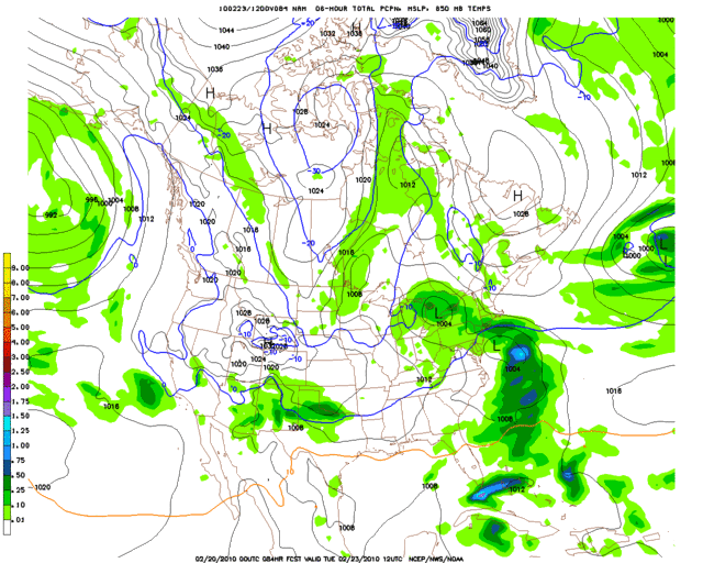
#7836 Postby Extremeweatherguy » Fri Feb 19, 2010 9:56 pm

The 00z NAM is similar to the 18z GFS in that it looks to bring the heaviest precipitation further north. According to this run, the greatest impacts from the storm would be near the Red River (+/- 100 to 150 miles north and south)...

Image

To be fair though, the NAM only goes out to Tuesday morning. We don't know for sure what happens just beyond this point.
0 likes   

User avatar
Ntxw
Storm2k Moderator
Storm2k Moderator
Posts: 22790
Joined: Wed Oct 21, 2009 6:34 pm
Location: DFW, Texas

Re:

#7837 Postby Ntxw » Fri Feb 19, 2010 9:58 pm

Extremeweatherguy wrote:The 00z NAM is similar to the 18z GFS in that it looks to bring the heaviest precipitation further north. According to this run, the greatest impacts from the storm would be near the Red River (+/- 100 to 150 miles north and south)...

Image


The precip shield is streaming from NW to SE.

Edit: Actually the bulk of the precip (if it were to be on par with the GFS would then shift south with the incoming moisture from NM.) But this is just personal projectory from what I saw on the GFS.
0 likes   
The above post and any post by Ntxw is NOT an official forecast and should not be used as such. It is just the opinion of the poster and may or may not be backed by sound meteorological data. It is NOT endorsed by any professional institution including Storm2k. For official information, please refer to NWS products.


  Help support Storm2K!

Help Support Storm2K


User avatar
srainhoutx
S2K Supporter
S2K Supporter
Posts: 6919
Age: 67
Joined: Sun Jan 14, 2007 11:34 am
Location: Haywood County, NC
Contact:

Re: Texas winter wx thread (2009-2010)

#7838 Postby srainhoutx » Fri Feb 19, 2010 10:01 pm

Look at the Upper flow via the NAM. A surge of some mighty chilly air heading south IMHO. I see some -36 C temps in Canada. The 850mb temps are lined up along the Rockies into the Great Basin.
0 likes   
Carla/Alicia/Jerry(In The Eye)/Michelle/Charley/Ivan/Dennis/Katrina/Rita/Wilma/Ike/Harvey

Member: National Weather Association
Wx Infinity Forums
http://wxinfinity.com/index.php

Facebook.com/WeatherInfinity
Twitter @WeatherInfinity

User avatar
Extremeweatherguy
Category 5
Category 5
Posts: 11095
Joined: Mon Oct 10, 2005 8:13 pm
Location: Florida

Re: Re:

#7839 Postby Extremeweatherguy » Fri Feb 19, 2010 10:08 pm

Ntxw wrote:
Extremeweatherguy wrote:The 00z NAM is similar to the 18z GFS in that it looks to bring the heaviest precipitation further north. According to this run, the greatest impacts from the storm would be near the Red River (+/- 100 to 150 miles north and south)...

[img]--l.gif[/img]


The precip shield is streaming from NW to SE.

Edit: Actually the bulk of the precip (if it were to be on par with the GFS would then shift south with the incoming moisture from NM.) But this is just personal projectory from what I saw on the GFS.
Yeah, there is some southward component to the precipitation shield, but it also looks to be expanding at the same time so its hard to get a good picture of what exactly is happening. It definitely doesn't look as far south as the 12z GFS was depicting earlier though. During the same time period the 12z GFS had the heaviest precipitation centered much further south and west than what is being shown in tonight's 00z NAM run.

(12z GFS valid the same time: http://i43.photobucket.com/albums/e371/ ... 096l-2.gif ).

*edited to convert to photobucket image
Last edited by Extremeweatherguy on Fri Feb 19, 2010 10:12 pm, edited 2 times in total.
0 likes   

User avatar
Ntxw
Storm2k Moderator
Storm2k Moderator
Posts: 22790
Joined: Wed Oct 21, 2009 6:34 pm
Location: DFW, Texas

#7840 Postby Ntxw » Fri Feb 19, 2010 10:10 pm

:uarrow: As I stated before EWG, this storm is very similar in looks to last thurs' storm and that southern Oklahoma shouldn't write it off.
0 likes   
The above post and any post by Ntxw is NOT an official forecast and should not be used as such. It is just the opinion of the poster and may or may not be backed by sound meteorological data. It is NOT endorsed by any professional institution including Storm2k. For official information, please refer to NWS products.


  Help support Storm2K!

Help Support Storm2K


Return to “Winter Weather”

Who is online

Users browsing this forum: No registered users and 337 guests