Texas winter wx thread (2009-2010)
Moderator: S2k Moderators
Forum rules
 The posts in this forum are NOT official forecast and should not be used as such. They are just the opinion of the poster and may or may not be backed by sound meteorological data. They are NOT endorsed by any professional institution or STORM2K.

The posts in this forum are NOT official forecast and should not be used as such. They are just the opinion of the poster and may or may not be backed by sound meteorological data. They are NOT endorsed by any professional institution or STORM2K.
-
WacoWx
- Category 2

- Posts: 692
- Joined: Mon Dec 28, 2009 4:14 pm
- Location: NOT Waco, TX ----> Dallas, TX
Re: Texas winter wx thread (2009-2010)
I REALLY hope this doesnt trend any further south for the Waco area. any Waco estimates?
0 likes

Re: Texas winter wx thread (2009-2010)
rkbjunior wrote:
So you're telling me there's a chance!!!
Last night the Austin area was at the .5 inch mark. This morning we have a winter weather watch and now we're at 2-4 inches. The morning met on KVUE said the northern counties may get upgraded to a warning tomorrow.

Ahh, much better
0 likes
-
Extremeweatherguy

- Category 5

- Posts: 11095
- Joined: Mon Oct 10, 2005 8:13 pm
- Location: Florida
Re: Texas winter wx thread (2009-2010)
The FW NWS office thinks you could see 4-6 inches..WacoWx wrote:I REALLY hope this doesnt trend any further south for the Waco area. any Waco estimates?
0 likes
-
srainhoutx

- S2K Supporter

- Posts: 6919
- Age: 68
- Joined: Sun Jan 14, 2007 11:34 am
- Location: Haywood County, NC
- Contact:
Re: Texas winter wx thread (2009-2010)
Appears the NAM is coming in a bit cooler and 'hinting' of banding from Austin to just N and W of DT Houston and points E. Still a was out and things can change, but this will be a very close call for us in SE TX. Central TX looks good IMHO. 
0 likes
Carla/Alicia/Jerry(In The Eye)/Michelle/Charley/Ivan/Dennis/Katrina/Rita/Wilma/Ike/Harvey
Member: National Weather Association
Wx Infinity Forums
http://wxinfinity.com/index.php
Facebook.com/WeatherInfinity
Twitter @WeatherInfinity
Member: National Weather Association
Wx Infinity Forums
http://wxinfinity.com/index.php
Facebook.com/WeatherInfinity
Twitter @WeatherInfinity
-
wxman57

- Moderator-Pro Met

- Posts: 23170
- Age: 68
- Joined: Sat Jun 21, 2003 8:06 pm
- Location: Houston, TX (southwest)
Re: Texas winter wx thread (2009-2010)
srainhoutx wrote:Appears the NAM is coming in a bit cooler and 'hinting' of banding from Austin to just N and W of DT Houston and points E. Still a was out and things can change, but this will be a very close call for us in SE TX. Central TX looks good IMHO.
12Z NAM says nothing anywhere in Harris County. Much smaller area of snow compared to GFS. I've followed the NAM for the past few events and it has a poor track record.
0 likes
-
txwxwatcher
- Tropical Storm

- Posts: 105
- Joined: Thu Feb 18, 2010 10:00 pm
Re: Texas winter wx thread (2009-2010)
My gut tells me that this is not quite through pushing southward. Original prediction stands for significant accumulating snow in College Station as well as for snow in Houston. If this goes just the slightest bit more south, a widespread area of Houston should see accumulating snow.
(This is NOT an official forecast)
(This is NOT an official forecast)
0 likes
-
srainhoutx
- S2K Supporter
- Posts: 6919
- Age: 68
- Joined: Sun Jan 14, 2007 11:34 am
- Location: Haywood County, NC
- Contact:
Re: Texas winter wx thread (2009-2010)
wxman57 wrote:srainhoutx wrote:Appears the NAM is coming in a bit cooler and 'hinting' of banding from Austin to just N and W of DT Houston and points E. Still a was out and things can change, but this will be a very close call for us in SE TX. Central TX looks good IMHO.
12Z NAM says nothing anywhere in Harris County. Much smaller area of snow compared to GFS. I've followed the NAM for the past few events and it has a poor track record.
Just looking at the H5 and 700mb wxman57. I do agree the NAM has not been useful concerning the 'finer details', but as always I like to look at "all the tools in the tool box".
0 likes
Carla/Alicia/Jerry(In The Eye)/Michelle/Charley/Ivan/Dennis/Katrina/Rita/Wilma/Ike/Harvey
Member: National Weather Association
Wx Infinity Forums
http://wxinfinity.com/index.php
Facebook.com/WeatherInfinity
Twitter @WeatherInfinity
Member: National Weather Association
Wx Infinity Forums
http://wxinfinity.com/index.php
Facebook.com/WeatherInfinity
Twitter @WeatherInfinity
Re: Texas winter wx thread (2009-2010)
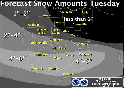
This is a little snippet that caught my attention this morning out of the FTW NWS offfice.
WE WILL CONTINUE TO FORECAST THE HIGHEST AMOUNTS
OVER THE SOUTHERN HALF OF THE CWA...AND NOW ARE HOMING IN ON THE
AREA ALONG AND SOUTH OF A COMANCHE...WACO...PALESTINE LINE FOR
MORE THAN 4 INCHES. THE FAR SOUTHERN CWA WILL HAVE THE BEST
COMBINATION OF LIFT OCCURRING FROM BOTH ISENTROPIC UPGLIDE AND
FRONTOGENESIS. THIS AREA WILL ALSO HAVE ELEVATED CONVECTIVE
INSTABILITY AVAILABLE AS HIGHER THETA-E VALUES FROM THE GULF ARE
DRAWN NORTHWARD. WE EXPECT SOME INTENSE BANDS OF SNOW IN THIS
AREA...WITH SNOWFALL RATES OF 1-2 INCHES AN HOUR POSSIBLE.
I don't think I've ever seen them forecast heavy snow in advanc especially 24-36 hours before said event!
I'll assume this is to better forecasting skills, but also hope that they are still underestimating-hehe
WE WILL CONTINUE TO FORECAST THE HIGHEST AMOUNTS
OVER THE SOUTHERN HALF OF THE CWA...AND NOW ARE HOMING IN ON THE
AREA ALONG AND SOUTH OF A COMANCHE...WACO...PALESTINE LINE FOR
MORE THAN 4 INCHES. THE FAR SOUTHERN CWA WILL HAVE THE BEST
COMBINATION OF LIFT OCCURRING FROM BOTH ISENTROPIC UPGLIDE AND
FRONTOGENESIS. THIS AREA WILL ALSO HAVE ELEVATED CONVECTIVE
INSTABILITY AVAILABLE AS HIGHER THETA-E VALUES FROM THE GULF ARE
DRAWN NORTHWARD. WE EXPECT SOME INTENSE BANDS OF SNOW IN THIS
AREA...WITH SNOWFALL RATES OF 1-2 INCHES AN HOUR POSSIBLE.
I don't think I've ever seen them forecast heavy snow in advanc
I'll assume this is to better forecasting skills, but also hope that they are still underestimating-hehe
0 likes

Re: Texas winter wx thread (2009-2010)
vbhoutex wrote:jg5894 wrote:CypressMike wrote:I hope we finally get some real snow here in NW Harris County. When I moved to Cypress, I thought I'd have a better chance of getting snow that those in the city and southern suburbs. Since I moved here in 2004, exactly the opposite is true. It just isn't fair!!!!!!!!!!
Hello everyone. I have been a member for awhile but this is my first post. Cypressmike i live South of Houston in the Clear Lake area and when i moved here back in 93 i never thought i would have seen as much snow as i have. I always thought that living north and west of town would be where the better chances for snow would be. The great thing about it is that my kids have enjoyed it. The 2004 event was my first real taste of snow and i was like a kid in a candy store!
Now you get an "official" welcome from me!

Thank You Sir! How about this, i won't steal your snow this time.We share!

0 likes
-
WacoWx
- Category 2
- Posts: 692
- Joined: Mon Dec 28, 2009 4:14 pm
- Location: NOT Waco, TX ----> Dallas, TX
Re: Texas winter wx thread (2009-2010)
I've heard the term "banding" a lot in the last few pages. Exactly what is banding? When I follow heavy snow bands, they are usually coming off of one of the Great Lakes and its essentially a band that trains over the same area due to consistant wind flow over a moisture source (lake). If I am understanding this correctly, what is the source going to be to allow for this banding? The Low itself I assume working with the Gulf?
I'm getting a feeling that the most significant accumulations are going to be located to my SE, if its cold enough, because of more moisture to work with? And in which directoin will these bands be moving? SW to NE or NW to SE?
I'm getting a feeling that the most significant accumulations are going to be located to my SE, if its cold enough, because of more moisture to work with? And in which directoin will these bands be moving? SW to NE or NW to SE?
0 likes

-
Portastorm

- Storm2k Moderator

- Posts: 9954
- Age: 63
- Joined: Fri Jul 11, 2003 9:16 am
- Location: Round Rock, TX
- Contact:
Re: Texas winter wx thread (2009-2010)
Here is the "latest" from Houston pro met Jeff Lindner:
Significant Winter Storm event heading for SE TX.Accumulating snowfall expected Tuesday over portions of SE TX.
Winter Storm Watch issued for the following counties: Brazos, Burleson, Grimes, Washington, Montgomery, Walker, Houston, Madison, Trinity, San Jacinto, and Polk.
Discussion:
Cold air advection in progress this morning behind the late Sunday cold front. Cold arctic dome over the central plains will filter southward today while the next upper level storm noted over NV this morning makes the eastward turn and begins it treck toward TX. Stratus deck this morning may break up some this afternoon, before high clouds begin to arrive from the west. Clouds will thicken and lower tonight as moisture and lift increase.
Tuesday:
Strong upper level storm drops toward the Big Bend area with a developing shield of winter precip. Over much of central TX by morning. Forecast soundings show the air mass over the area dry and cold by Tuesday morning. A dry layer in the 900-800mb level will support some room for evaporative cooling of the air column with the onset of rain/snow Tuesday morning over our NW counties first and then spreading SE during the afternoon hours. Meso scale models continue to point toward a fairly unstable layer in the snow growth area around 700mb over the northern portions of SE TX Tuesday afternoon. Past events and studies with such instability (Dallas 2 week ago, and Victoria in Dec 2004) suggest the formation of meso scale banding and potential for very heavy snowfall rates. 700mb front will also be introduced into the mix to add forcing over our northern counties. May see a band of very heavy snow develop from College Station to Huntsville Tuesday afternoon/evening with significant accumulations.
Tuesday night:
Rain/snow mix will spread toward the coast with a change over to all snow across inland SE TX. At this time it appears the rain will mix with snow by mid afternoon toward Harris County and then change to snow after dark Tuesday as far south as US 59. Surface temperatures will fall toward freezing during the early evening hours as far south as I-10 as accumulating snow pack just to the north advects colder surface air southward. The southward extent of accumulation will likely end up over Austin/Waller/Harris/Liberty counties.
Accumulations:
Tuesday/Tuesday night with accumulations of 2-4 inches and isolated locations of 6+” possible.
Rain/snow mix will begin Tuesday morning and change to all snow Tuesday afternoon. Accumulations of 2-3” is likely with isolated totals of 3-5” possible.
Rain will start the event changing to a rain/snow mix during the mid afternoon and all snow after dark. Accumulations of generally less than 1 inch is likely.
Rain will start the event changing to rain/snow after dark Tuesday and possibly all snow before ending late Tuesday. Most of what falls in this region will melt on contact as surface temperatures struggle to get to freezing.
Surface temperatures are forecast to be in the 32-35 degree range for much of the day Tuesday as the snow falls which indicates a lot will melt on impact, except where heavy snow bands develop. Temperatures will drop Tuesday evening to or below freezing along and N of I-10 where melted snow on bridges and overpasses may begin to freeze. Additionally as surface temperatures fall toward/below freezing Tuesday evening snowfall will begin to accumulate faster mainly on elevated and grassy surfaces. Could see some icing/glazing of bridges and overpasses Tuesday evening into Wednesday morning over the northern ½ of the area.
While confidence is growing in this event, the amount of accumulation and where the rain/snow line ends up remains in some question. Forecasting meso banding location is extremely difficult, but very high impact and much of this will not be known until the event is underway.
0 likes
-
WacoWx
- Category 2
- Posts: 692
- Joined: Mon Dec 28, 2009 4:14 pm
- Location: NOT Waco, TX ----> Dallas, TX
Re: Texas winter wx thread (2009-2010)
Portastorm, Salado doesnt appear to be too far off from the main action. I'll take 3 inches...no prob!
0 likes
-
Nederlander
- S2K Supporter
- Posts: 1259
- Joined: Sat Jul 19, 2008 4:28 pm
- Location: Conroe, TX
Re: Texas winter wx thread (2009-2010)
planning on taking a little road trip tomorrow evening... which is a better bet.. conroe area, or woodville area? cant do college station, thats a three hour trek..
0 likes
-
Portastorm
- Storm2k Moderator
- Posts: 9954
- Age: 63
- Joined: Fri Jul 11, 2003 9:16 am
- Location: Round Rock, TX
- Contact:
Re: Texas winter wx thread (2009-2010)
WacoWx wrote:Portastorm, Salado doesnt appear to be too far off from the main action. I'll take 3 inches...no prob!
Of all of us, you ought to feel confident. You're pretty much in the bullseye!
0 likes
-
Tireman4

- S2K Supporter
- Posts: 5903
- Age: 60
- Joined: Fri Jun 30, 2006 1:08 pm
- Location: Humble, Texas
- Contact:
Re: Texas winter wx thread (2009-2010)
txagwxman wrote:jg5894 wrote:CypressMike wrote:I hope we finally get some real snow here in NW Harris County. When I moved to Cypress, I thought I'd have a better chance of getting snow that those in the city and southern suburbs. Since I moved here in 2004, exactly the opposite is true. It just isn't fair!!!!!!!!!!
Hello everyone. I have been a member for awhile but this is my first post. Cypressmike i live South of Houston in the Clear Lake area and when i moved here back in 93 i never thought i would have seen as much snow as i have. I always thought that living north and west of town would be where the better chances for snow would be. The great thing about it is that my kids have enjoyed it. The 2004 event was my first real taste of snow and i was like a kid in a candy store!
In 1973, it snowed 3x times in Houston...similar El Nino weather pattern (-NAO). We had 1-4" on each snow storm.
Yep... I was in La Marque at the time. Yep, it snowed. It was great for a 7 1/2 year old to play in it...
0 likes
-
WacoWx
- Category 2
- Posts: 692
- Joined: Mon Dec 28, 2009 4:14 pm
- Location: NOT Waco, TX ----> Dallas, TX
Re: Texas winter wx thread (2009-2010)
Portastorm wrote:WacoWx wrote:Portastorm, Salado doesnt appear to be too far off from the main action. I'll take 3 inches...no prob!
Of all of us, you ought to feel confident. You're pretty much in the bullseye!
Dont get me wrong, I'm VERY confident...but I'm also very greedy. I want the absolute most snow out of everyone so I dont have to go to work Tuesday afternoon and Wednesday am.
0 likes
Re: Texas winter wx thread (2009-2010)
Portastorm - can you post a link to Jeff's site? Thanks.
0 likes
Any forecast I make is based on my opinion only. Please refer to the NWS or NHC for official forecasts.
-
Weatherdude20
Re: Texas winter wx thread (2009-2010)
Im thinking Brownwood to Waco line will be the center of attention for a widespread 6". Goldthwaite to Gatesville line could be the bulls eye with 8-10".
0 likes
-
Portastorm
- Storm2k Moderator
- Posts: 9954
- Age: 63
- Joined: Fri Jul 11, 2003 9:16 am
- Location: Round Rock, TX
- Contact:
Re: Texas winter wx thread (2009-2010)
Geez ... EWX is all over the map. I should have figured. First they issue a WSW for the Austin metro area and include a graphic for 2-4 inches of snow over all of Travis County. Now, they just issued an SPS at 10 am and say 1/2 to 1 inch accumulation. Clearly, they've trended for lighter amounts. My question ... based on what? The 12z NAM? 
0 likes
Who is online
Users browsing this forum: Stratton23, wxman22 and 52 guests