Texas Winter 2017-2018

Winter Weather Discussion

Moderator: S2k Moderators

Forum rules

The posts in this forum are NOT official forecast and should not be used as such. They are just the opinion of the poster and may or may not be backed by sound meteorological data. They are NOT endorsed by any professional institution or STORM2K.

Help Support Storm2K
Message
Author
Brent
S2K Supporter
S2K Supporter
Posts: 37143
Age: 35
Joined: Sun May 16, 2004 10:30 pm
Location: Tulsa Oklahoma
Contact:

Re: Texas Winter 2017-2018

#8881 Postby Brent » Tue Feb 20, 2018 9:27 pm

bubba hotep wrote:Hey, Denton and Collin County, it was nice to know ya!

Image


:roflmao:

This might be the best NAM snow map ever!
1 likes   
#neversummer

User avatar
bubba hotep
S2K Supporter
S2K Supporter
Posts: 5609
Joined: Wed Dec 28, 2016 1:00 am
Location: Collin County Texas

Re: Texas Winter 2017-2018

#8882 Postby bubba hotep » Tue Feb 20, 2018 9:28 pm

downsouthman1 wrote:
weatherdude1108 wrote:Huge blowup of storms in the valley around MCALLEN and points north, moving northwardish! Not sure what to make of it(?).

I'm watching it. Trying to ascertain whether it'll hit San Antonio and Austin or trek east of there.


Looks cool on the new GOES

Image
2 likes   
Winter time post are almost exclusively focused on the DFW area.

User avatar
South Texas Storms
Professional-Met
Professional-Met
Posts: 4032
Joined: Thu Jun 24, 2010 12:28 am
Location: Houston, TX

Re: Texas Winter 2017-2018

#8883 Postby South Texas Storms » Tue Feb 20, 2018 9:29 pm

weatherdude1108 wrote:Huge blowup of storms in the valley around MCALLEN and points north, moving northwardish! Not sure what to make of it(?).


Unfortunately I think that complex of storms blew up too far south to bring us the heaviest rainfall. I hope it tracks far enough north so we can at least get an inch or so.
1 likes   

Ntxw
Storm2k Moderator
Storm2k Moderator
Posts: 21565
Joined: Wed Oct 21, 2009 6:34 pm
Location: DFW, Texas

Re: Texas Winter 2017-2018

#8884 Postby Ntxw » Tue Feb 20, 2018 9:31 pm

NAM profiles are not of snow. Very shallow, perhaps heavy rain/sleet mix. Maybe accretion on some elevated objects NW side of DFW. 850s are way too warm for much more.
1 likes   
The above post and any post by Ntxw is NOT an official forecast and should not be used as such. It is just the opinion of the poster and may or may not be backed by sound meteorological data. It is NOT endorsed by any professional institution including Storm2k. For official information, please refer to NWS products.

  Help support Storm2K!
Help Support Storm2K

JayDT
Category 1
Category 1
Posts: 317
Joined: Tue Dec 16, 2014 12:55 pm
Location: Dallas, Texas

Re: Texas Winter 2017-2018

#8885 Postby JayDT » Tue Feb 20, 2018 9:32 pm

bubba hotep wrote:DFW zoom from WxBell

Image


Just a little further into Dallas County and it would be perfect
0 likes   

User avatar
Cerlin
Category 5
Category 5
Posts: 1177
Age: 22
Joined: Thu Dec 08, 2016 12:06 am
Location: Norman, OK

Re: Texas Winter 2017-2018

#8886 Postby Cerlin » Tue Feb 20, 2018 9:34 pm

should we take these models with a grain of sleet and anticipate for virtually no winter weather again?
1 likes   
Undergraduate Meteorology Student at the University of Oklahoma and Operator at the Oklahoma Mesonet.
All opinions independent of employers and the university.

Jarodm12
Category 1
Category 1
Posts: 337
Joined: Sat Jan 29, 2011 8:05 pm

Re: Texas Winter 2017-2018

#8887 Postby Jarodm12 » Tue Feb 20, 2018 9:35 pm

Ntxw wrote:NAM profiles are not of snow. Very shallow, perhaps heavy rain/sleet mix. Maybe accretion on some elevated objects NW side of DFW. 850s are way too warm for much more.


yes but arent tempatures still being initialized too warm.. every run is trending colder with a sleet mixture ( at the very least) into dfw
0 likes   

Gigem12
Tropical Low
Tropical Low
Posts: 11
Age: 37
Joined: Tue Dec 26, 2017 3:46 pm
Location: Fort Worth and Garland

Re: Texas Winter 2017-2018

#8888 Postby Gigem12 » Tue Feb 20, 2018 9:36 pm

Cerlin wrote:should we take these models with a grain of sleet and anticipate for virtually no winter weather again?


Don't even need the grain of salt
1 likes   

User avatar
bubba hotep
S2K Supporter
S2K Supporter
Posts: 5609
Joined: Wed Dec 28, 2016 1:00 am
Location: Collin County Texas

Re: Texas Winter 2017-2018

#8889 Postby bubba hotep » Tue Feb 20, 2018 9:36 pm

Cerlin wrote:should we take these models with a grain of sleet and anticipate for virtually no winter weather again?


Always, see the post by NTWX above and my post from earlier today regarding the setup not being favorable for accumulation of anything.
1 likes   
Winter time post are almost exclusively focused on the DFW area.

Brent
S2K Supporter
S2K Supporter
Posts: 37143
Age: 35
Joined: Sun May 16, 2004 10:30 pm
Location: Tulsa Oklahoma
Contact:

Re: Texas Winter 2017-2018

#8890 Postby Brent » Tue Feb 20, 2018 9:38 pm

if you look at the frames on the 12k NAM the frozen precip never really touches the metro... mostly NW of Denton. Its heavy rain(very heavy rain at that) in Dallas and McKinney on every frame.
1 likes   
#neversummer

Ntxw
Storm2k Moderator
Storm2k Moderator
Posts: 21565
Joined: Wed Oct 21, 2009 6:34 pm
Location: DFW, Texas

Re: Texas Winter 2017-2018

#8891 Postby Ntxw » Tue Feb 20, 2018 9:43 pm

Jarodm12 wrote:
Ntxw wrote:NAM profiles are not of snow. Very shallow, perhaps heavy rain/sleet mix. Maybe accretion on some elevated objects NW side of DFW. 850s are way too warm for much more.


yes but arent tempatures still being initialized too warm.. every run is trending colder with a sleet mixture ( at the very least) into dfw


I've been on the side that heavy rain with sleet/hail mixed in is very possible. Colder at the surface isn't enough for all changeover the column needs deeper cold. If it turns out colder then maybe some ice accretion on trees and cars etc. Assuming much colder. But in a weather experience sense, visually you may just see very heavy cold rain.
0 likes   
The above post and any post by Ntxw is NOT an official forecast and should not be used as such. It is just the opinion of the poster and may or may not be backed by sound meteorological data. It is NOT endorsed by any professional institution including Storm2k. For official information, please refer to NWS products.


  Help support Storm2K!

Help Support Storm2K


Jarodm12
Category 1
Category 1
Posts: 337
Joined: Sat Jan 29, 2011 8:05 pm

Re: Texas Winter 2017-2018

#8892 Postby Jarodm12 » Tue Feb 20, 2018 9:48 pm

Ntxw wrote:
Jarodm12 wrote:
Ntxw wrote:NAM profiles are not of snow. Very shallow, perhaps heavy rain/sleet mix. Maybe accretion on some elevated objects NW side of DFW. 850s are way too warm for much more.


yes but arent tempatures still being initialized too warm.. every run is trending colder with a sleet mixture ( at the very least) into dfw


I've been on the side that heavy rain with sleet/hail mixed in is very possible. Colder at the surface isn't enough for all changeover the column needs deeper cold. If it turns out colder then maybe some ice accretion on trees and cars etc. Assuming much colder. But in a weather experience sense, visually you may just see very heavy cold rain.


Thank you, what do you think about the sref latest freezing rain probabilities ?
0 likes   

User avatar
starsfan65
Category 2
Category 2
Posts: 675
Age: 46
Joined: Thu Dec 17, 2015 1:18 pm
Location: Garland,Tx

Re: Texas Winter 2017-2018

#8893 Postby starsfan65 » Tue Feb 20, 2018 9:50 pm

Ntxw wrote:
Jarodm12 wrote:
Ntxw wrote:NAM profiles are not of snow. Very shallow, perhaps heavy rain/sleet mix. Maybe accretion on some elevated objects NW side of DFW. 850s are way too warm for much more.


yes but arent tempatures still being initialized too warm.. every run is trending colder with a sleet mixture ( at the very least) into dfw


I've been on the side that heavy rain with sleet/hail mixed in is very possible. Colder at the surface isn't enough for all changeover the column needs deeper cold. If it turns out colder then maybe some ice accretion on trees and cars etc. Assuming much colder. But in a weather experience sense, visually you may just see very heavy cold rain.

Are ya'll sure?
0 likes   

User avatar
bubba hotep
S2K Supporter
S2K Supporter
Posts: 5609
Joined: Wed Dec 28, 2016 1:00 am
Location: Collin County Texas

Re: Texas Winter 2017-2018

#8894 Postby bubba hotep » Tue Feb 20, 2018 9:53 pm

21z SREF mean gets DFW very close to freezing with individual members in the mid-20s. Anything below 30F and things would certainly start to get concerning around the metroplex tomorrow morning. The colder side of guidance has been winning out so far this evening...
2 likes   
Winter time post are almost exclusively focused on the DFW area.

User avatar
Cerlin
Category 5
Category 5
Posts: 1177
Age: 22
Joined: Thu Dec 08, 2016 12:06 am
Location: Norman, OK

Re: Texas Winter 2017-2018

#8895 Postby Cerlin » Tue Feb 20, 2018 9:53 pm

starsfan65 wrote:
Ntxw wrote:
Jarodm12 wrote:

yes but arent tempatures still being initialized too warm.. every run is trending colder with a sleet mixture ( at the very least) into dfw


I've been on the side that heavy rain with sleet/hail mixed in is very possible. Colder at the surface isn't enough for all changeover the column needs deeper cold. If it turns out colder then maybe some ice accretion on trees and cars etc. Assuming much colder. But in a weather experience sense, visually you may just see very heavy cold rain.

Are ya'll sure?

They’re trustworthy members. No one can be completely certain but their word is pretty reputable IMO
0 likes   
Undergraduate Meteorology Student at the University of Oklahoma and Operator at the Oklahoma Mesonet.
All opinions independent of employers and the university.

Brent
S2K Supporter
S2K Supporter
Posts: 37143
Age: 35
Joined: Sun May 16, 2004 10:30 pm
Location: Tulsa Oklahoma
Contact:

Re: Texas Winter 2017-2018

#8896 Postby Brent » Tue Feb 20, 2018 9:54 pm

its been so warm here anyway even if there was ice in DFW I doubt it'd be that significant(certainly not on the ground). But most likely its just a very cold miserable rain
Last edited by Brent on Tue Feb 20, 2018 9:55 pm, edited 2 times in total.
2 likes   
#neversummer

Ntxw
Storm2k Moderator
Storm2k Moderator
Posts: 21565
Joined: Wed Oct 21, 2009 6:34 pm
Location: DFW, Texas

Re: Texas Winter 2017-2018

#8897 Postby Ntxw » Tue Feb 20, 2018 9:54 pm

Jarodm12 wrote:
Ntxw wrote:
Jarodm12 wrote:

yes but arent tempatures still being initialized too warm.. every run is trending colder with a sleet mixture ( at the very least) into dfw


I've been on the side that heavy rain with sleet/hail mixed in is very possible. Colder at the surface isn't enough for all changeover the column needs deeper cold. If it turns out colder then maybe some ice accretion on trees and cars etc. Assuming much colder. But in a weather experience sense, visually you may just see very heavy cold rain.


Thank you, what do you think about the sref latest freezing rain probabilities ?


I'm not really well versed in SREF. If DFW was below freezing by midnight, I'd be concerned. Otherwise temps are still too marginal despite colder than forecast (they were too warm to begin with).
0 likes   
The above post and any post by Ntxw is NOT an official forecast and should not be used as such. It is just the opinion of the poster and may or may not be backed by sound meteorological data. It is NOT endorsed by any professional institution including Storm2k. For official information, please refer to NWS products.


  Help support Storm2K!

Help Support Storm2K


downsouthman1
Category 2
Category 2
Posts: 652
Age: 44
Joined: Fri Jan 07, 2011 8:14 pm
Location: Manor, TX

Re: Texas Winter 2017-2018

#8898 Postby downsouthman1 » Tue Feb 20, 2018 9:55 pm

Sounds like people are asking for a skew-T. But even then, hopefuls will be hopeful. :D
0 likes   
Not a professional MET! My posts are merely speculation.

SGJ
Tropical Low
Tropical Low
Posts: 15
Joined: Sat Nov 19, 2016 11:36 pm

Re: Texas Winter 2017-2018

#8899 Postby SGJ » Tue Feb 20, 2018 9:55 pm

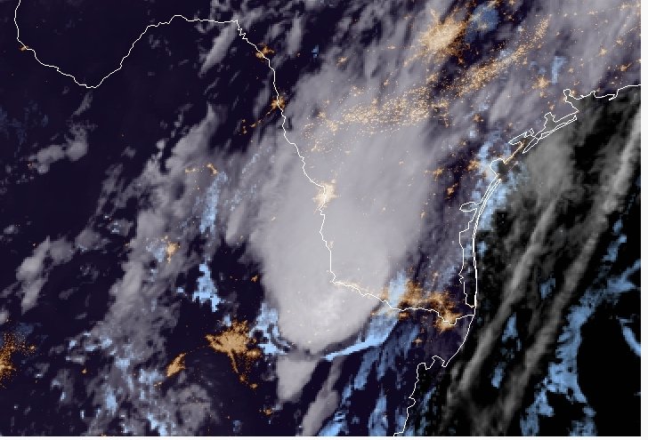
bubba hotep wrote:The front seems to losing some momentum and back building/training appears to be setting up over Dallas & Collin County.

Image


What is Back Building / Training? Does that mean we have a better or worse chance to get winter precip here in Collin County?

If it means are chances are improving, are they really?
Or will the precipitation evaporate / disappear as soon as temps get close to freezing?

We are literally getting HAMMERED in Wylie. I can't believe how much rain has fallen and continues to fall.

Thank you all for sharing your expertise!!!

(And now I'n seeing a Live Broadcast from Pete Delkus is getting ready to start. He hasn't begun yet so I'm wondering if he's going to mention winter weather for us...I'm skeptical...!)
1 likes   

User avatar
starsfan65
Category 2
Category 2
Posts: 675
Age: 46
Joined: Thu Dec 17, 2015 1:18 pm
Location: Garland,Tx

Re: Texas Winter 2017-2018

#8900 Postby starsfan65 » Tue Feb 20, 2018 9:56 pm

Ntxw wrote:
Jarodm12 wrote:
Ntxw wrote:
I've been on the side that heavy rain with sleet/hail mixed in is very possible. Colder at the surface isn't enough for all changeover the column needs deeper cold. If it turns out colder then maybe some ice accretion on trees and cars etc. Assuming much colder. But in a weather experience sense, visually you may just see very heavy cold rain.


Thank you, what do you think about the sref latest freezing rain probabilities ?


I'm not really well versed in SREF. If DFW was below freezing by midnight, I'd be concerned. Otherwise temps are still too marginal despite colder than forecast (they were too warm to begin with).

I want sleet!!!
1 likes   


Return to “Winter Weather”

Who is online

Users browsing this forum: No registered users and 22 guests