Siberian Express January/February 2011

Winter Weather Discussion

Moderator: S2k Moderators

Forum rules

The posts in this forum are NOT official forecast and should not be used as such. They are just the opinion of the poster and may or may not be backed by sound meteorological data. They are NOT endorsed by any professional institution or STORM2K.

Help Support Storm2K
Message
Author
User avatar
srainhoutx
S2K Supporter
S2K Supporter
Posts: 6919
Age: 66
Joined: Sun Jan 14, 2007 11:34 am
Location: Haywood County, NC
Contact:

Re:

#161 Postby srainhoutx » Wed Jan 12, 2011 8:31 am

Portastorm wrote:Blech ... the 0z model runs do not continue the trend of Arctic Armageddon which we saw yesterday.

I'll quote a line from one of my favorite movies -- Stripes -- when John Winger (Bill Murray) says: "And then .... depression set in."


And then the 06Z GFS brings it back. Flip Flop...

Image
0 likes   
Carla/Alicia/Jerry(In The Eye)/Michelle/Charley/Ivan/Dennis/Katrina/Rita/Wilma/Ike/Harvey

Member: National Weather Association
Wx Infinity Forums
http://wxinfinity.com/index.php

Facebook.com/WeatherInfinity
Twitter @WeatherInfinity

User avatar
wxman57
Moderator-Pro Met
Moderator-Pro Met
Posts: 22482
Age: 66
Joined: Sat Jun 21, 2003 8:06 pm
Location: Houston, TX (southwest)

Re: Re:

#162 Postby wxman57 » Wed Jan 12, 2011 9:13 am

srainhoutx wrote:
Portastorm wrote:Blech ... the 0z model runs do not continue the trend of Arctic Armageddon which we saw yesterday.

I'll quote a line from one of my favorite movies -- Stripes -- when John Winger (Bill Murray) says: "And then .... depression set in."


And then the 06Z GFS brings it back. Flip Flop...

http://i228.photobucket.com/albums/ee29 ... PNA240.gif


But the 6Z GFS only forecasts a 2m temp of 32 on Saturday the 22nd as the coldest low next week.
0 likes   

User avatar
srainhoutx
S2K Supporter
S2K Supporter
Posts: 6919
Age: 66
Joined: Sun Jan 14, 2007 11:34 am
Location: Haywood County, NC
Contact:

Re: Siberian Express January 2011

#163 Postby srainhoutx » Wed Jan 12, 2011 9:22 am

In SE TX, wxman57. Certainly not in the Great Lakes and Ohio Valley. :cheesy:

Image
0 likes   
Carla/Alicia/Jerry(In The Eye)/Michelle/Charley/Ivan/Dennis/Katrina/Rita/Wilma/Ike/Harvey

Member: National Weather Association
Wx Infinity Forums
http://wxinfinity.com/index.php

Facebook.com/WeatherInfinity
Twitter @WeatherInfinity

User avatar
Portastorm
Storm2k Moderator
Storm2k Moderator
Posts: 9787
Age: 61
Joined: Fri Jul 11, 2003 9:16 am
Location: South Austin, TX
Contact:

Re: Siberian Express January 2011

#164 Postby Portastorm » Wed Jan 12, 2011 9:42 am

I have not looked at the ensembles so perhaps they have a different look. But I'm rather confounded (yes folks, that happens easily!) by the look. The PNA is progged to go positive. Bitter cold air seems poised to cross the pole into northwest Canada. Usually this means some ridging develops in the west and brings it down.

Maybe we can chalk it up to models struggling with the pattern. Yeah, that's it! The models are struggling with the pattern. That's our story and I'm sticking to it.
0 likes   

User avatar
wxman57
Moderator-Pro Met
Moderator-Pro Met
Posts: 22482
Age: 66
Joined: Sat Jun 21, 2003 8:06 pm
Location: Houston, TX (southwest)

Re: Siberian Express January 2011

#165 Postby wxman57 » Wed Jan 12, 2011 10:02 am

[quote="srainhoutx"]In SE TX, wxman57. Certainly not in the Great Lakes and Ohio Valley. :cheesy:

http://i228.photobucket.com/albums/ee29 ... btest8.gif[quote]

Fortunately, I don't live up in the Great Lakes/Ohio Valley area, so I don't care how cold they get up there next week. They can have the next shot. ;-)
0 likes   

User avatar
Ivanhater
Storm2k Moderator
Storm2k Moderator
Posts: 10852
Age: 37
Joined: Fri Jul 01, 2005 8:25 am
Location: Pensacola

Re: Siberian Express January 2011

#166 Postby Ivanhater » Wed Jan 12, 2011 10:23 am

Models are latching onto another arctic outbreak heading into the U.S and making it down south. Obviously, the details of exactly where are not clear yet. Looks like Mrs. La Nina is still on her extended vacation. This winter has been anything but warm and dry.

Another 1052 high sliding out of Canada

Image

Image
0 likes   
Michael

Tejas89
Category 1
Category 1
Posts: 412
Joined: Mon Dec 28, 2009 9:25 pm
Location: DFW, TX

Re: Siberian Express January 2011

#167 Postby Tejas89 » Wed Jan 12, 2011 10:23 am

FW NWS alludes to another arctic front mid-next week, but models "do not have a good handle on it"...
0 likes   

User avatar
MGC
S2K Supporter
S2K Supporter
Posts: 5792
Joined: Sun Mar 23, 2003 9:05 pm
Location: Pass Christian MS, or what is left.

Re: Siberian Express January 2011

#168 Postby MGC » Wed Jan 12, 2011 12:08 pm

Yea, where is the La Nina warmth? 8th coldest December in the New Orleans area. It has been dry though....MGC
0 likes   

User avatar
GCANE
S2K Supporter
S2K Supporter
Posts: 10787
Joined: Mon Oct 22, 2007 8:03 am

Re: Siberian Express January 2011

#169 Postby GCANE » Wed Jan 12, 2011 1:10 pm

12Z GFS 240 Hrs out (1/22/11) looks absolutely wicked.

Temp anamolies bottom out at 850mb.


Image
0 likes   

Metalicwx220

Re: Re:

#170 Postby Metalicwx220 » Wed Jan 12, 2011 4:11 pm

srainhoutx wrote:
Portastorm wrote:Blech ... the 0z model runs do not continue the trend of Arctic Armageddon which we saw yesterday.

I'll quote a line from one of my favorite movies -- Stripes -- when John Winger (Bill Murray) says: "And then .... depression set in."


And then the 06Z GFS brings it back. Flip Flop...

Image

Cough cough probably gonna moderate a lot cough cough.
0 likes   

User avatar
srainhoutx
S2K Supporter
S2K Supporter
Posts: 6919
Age: 66
Joined: Sun Jan 14, 2007 11:34 am
Location: Haywood County, NC
Contact:

Re: Siberian Express January 2011

#171 Postby srainhoutx » Wed Jan 12, 2011 4:51 pm

:uarrow: Way too much spread in the ensembles. I'd give the models time to settle down before writing this off. :wink:
0 likes   
Carla/Alicia/Jerry(In The Eye)/Michelle/Charley/Ivan/Dennis/Katrina/Rita/Wilma/Ike/Harvey

Member: National Weather Association
Wx Infinity Forums
http://wxinfinity.com/index.php

Facebook.com/WeatherInfinity
Twitter @WeatherInfinity

Ntxw
Storm2k Moderator
Storm2k Moderator
Posts: 21511
Joined: Wed Oct 21, 2009 6:34 pm
Location: DFW, Texas

Re: Siberian Express January 2011

#172 Postby Ntxw » Wed Jan 12, 2011 5:12 pm

I see no reason models would bottle it up! At least for the central part of the United States :wink:

Image
0 likes   
The above post and any post by Ntxw is NOT an official forecast and should not be used as such. It is just the opinion of the poster and may or may not be backed by sound meteorological data. It is NOT endorsed by any professional institution including Storm2k. For official information, please refer to NWS products.

  Help support Storm2K!
Help Support Storm2K

User avatar
Portastorm
Storm2k Moderator
Storm2k Moderator
Posts: 9787
Age: 61
Joined: Fri Jul 11, 2003 9:16 am
Location: South Austin, TX
Contact:

Re: Siberian Express January 2011

#173 Postby Portastorm » Thu Jan 13, 2011 7:25 am

It appears that the operational model runs we are seeing this morning still struggle with the ongoing pattern. HPC suggests that until they (the models) figure out the Pacific, large discrepancies will exist downstream. Read on ...

PRELIMINARY EXTENDED FORECAST DISCUSSION
NWS HYDROMETEOROLOGICAL PREDICTION CENTER CAMP SPRINGS MD
237 AM EST THU JAN 13 2011

VALID 12Z MON JAN 17 2011 - 12Z THU JAN 20 2011

A LOW AMPLITUDE LONGWAVE TROUGH IS EXPECTED TO PREVAIL OVER THE
CENTRAL CONUS DAYS 3-5 BEFORE SHIFTING TOWARD THE EAST COAST DAY
6-7...WHILE IN THE WEST MAINLY ZONAL FLOW...WITH SOME DAY-TO-DAY
VARIABILITY...WILL LINGER THROUGH DAY 5 BEFORE A LONGWAVE RIDGE
BUILDS OVER THE EASTERN PACIFIC...WHICH IN TURN HELPS TO FORM A
TROUGH OVER THE ROCKIES. GENERALLY SPEAKING DETERMINISTIC SOLUTION
DIFFERENCES ARE LARGE AND RUN-TO-RUN CONTINUITY IS POOR AS EARLY
AS DAY 3...IN LARGE PART TO THE DIFFICULTY IN RESOLVING SMALL
SCALE SYSTEM DETAILS OVER THE PACIFIC WHICH AMPLIFY DOWNSTREAM AND
EVENTUALLY INTERACT WITH THE NORTHERN STREAM OVER CANADA. TO
ADDRESS THESE CONCERNS...THE PREFERENCE IS FOR A HEAVY DOSE OF THE
GLOBAL ENSEMBLE MEANS ALL DAYS...WITH ONLY 30 PERCENT THE 00Z
OPERATIONAL ECMWF MIXED WITH THE MEANS DAYS 3-5 TO EXTRACT AS MUCH
DETERMINISTIC DETAIL AS THE SOLUTION SPREAD SUPPORTS.
OTHERWISE...BY DAYS 6-7 THE PREFERENCE IS FOR 100 PERCENT ENSEMBLE
MEANS...WITH A SLIGHT PREFERENCE FOR THE ECMWF ENSEMBLE SUITE DUE
TO ITS HIGHER RESOLUTION AND GREATER NUMBER OF MEMBERS USED TO
CREATE THE MEAN. HOWEVER...THE 00Z GEFS MEAN IS VERY CLOSE AND
COULD BE USED AS AN ALTERNATIVE.
0 likes   

User avatar
Portastorm
Storm2k Moderator
Storm2k Moderator
Posts: 9787
Age: 61
Joined: Fri Jul 11, 2003 9:16 am
Location: South Austin, TX
Contact:

Re: Siberian Express January 2011

#174 Postby Portastorm » Thu Jan 13, 2011 2:16 pm

Both the 12z Euro and UKMet show strong ridging developing off the Pacific coast at 144 hrs. Hmmm ... more Arctic air on the way?! :wink:
0 likes   

User avatar
wxman57
Moderator-Pro Met
Moderator-Pro Met
Posts: 22482
Age: 66
Joined: Sat Jun 21, 2003 8:06 pm
Location: Houston, TX (southwest)

Re: Siberian Express January 2011

#175 Postby wxman57 » Thu Jan 13, 2011 2:39 pm

Portastorm wrote:Both the 12z Euro and UKMet show strong ridging developing off the Pacific coast at 144 hrs. Hmmm ... more Arctic air on the way?! :wink:


I'm afraid that's a good possibility. This may be a shallower layer of colder air, the kind that could lead to an ice storm in the Southern Plains with the trof axis well west of the Arctic air. Models won't handle this type of outbreak well at all, particularly the surface pressure pattern and front location.
0 likes   

Ntxw
Storm2k Moderator
Storm2k Moderator
Posts: 21511
Joined: Wed Oct 21, 2009 6:34 pm
Location: DFW, Texas

Re: Siberian Express January 2011

#176 Postby Ntxw » Thu Jan 13, 2011 6:02 pm

wxman57 wrote:I'm afraid that's a good possibility. This may be a shallower layer of colder air, the kind that could lead to an ice storm in the Southern Plains with the trof axis well west of the Arctic air. Models won't handle this type of outbreak well at all, particularly the surface pressure pattern and front location.


The heat miser agrees?! Hell is about to freeze over!
0 likes   
The above post and any post by Ntxw is NOT an official forecast and should not be used as such. It is just the opinion of the poster and may or may not be backed by sound meteorological data. It is NOT endorsed by any professional institution including Storm2k. For official information, please refer to NWS products.


  Help support Storm2K!

Help Support Storm2K


User avatar
Texas Snowman
Storm2k Moderator
Storm2k Moderator
Posts: 6023
Joined: Fri Jan 25, 2008 11:29 am
Location: Denison, Texas

Re: Siberian Express January 2011

#177 Postby Texas Snowman » Thu Jan 13, 2011 6:47 pm

Ntxw wrote:
wxman57 wrote:I'm afraid that's a good possibility. This may be a shallower layer of colder air, the kind that could lead to an ice storm in the Southern Plains with the trof axis well west of the Arctic air. Models won't handle this type of outbreak well at all, particularly the surface pressure pattern and front location.


The heat miser agrees?! Hell is about to freeze over!


Yep, that caught my attention too. When Wxman57 says there is a chance of Arctic air in Texas, look out. Better bundle up!!!!! :D
0 likes   
The above post and any post by Texas Snowman is NOT an official forecast and should not be used as such. It is just the opinion of the poster and may or may not be backed by sound meteorological data. It is NOT endorsed by any professional institution including storm2k.org. For official information, please refer to NWS products.

sherry
Tropical Low
Tropical Low
Posts: 20
Joined: Wed Dec 22, 2010 2:37 pm

Re: Siberian Express January 2011

#178 Postby sherry » Thu Jan 13, 2011 9:32 pm

I hope this stays away from NC. While I love snow my kids have missed a whole week of school. They are to go back on Tuesday. I don't want them home any longer than that.
0 likes   

User avatar
northjaxpro
S2K Supporter
S2K Supporter
Posts: 8900
Joined: Mon Sep 27, 2010 11:21 am
Location: Jacksonville, FL

#179 Postby northjaxpro » Sat Jan 15, 2011 11:09 am

1/15/11

Morning Long Range Discussion from Atlanta, GA Peachtree City WFO


From Atlanta,GA extended.....

LONG TERM /MONDAY NIGHT THROUGH FRIDAY/...
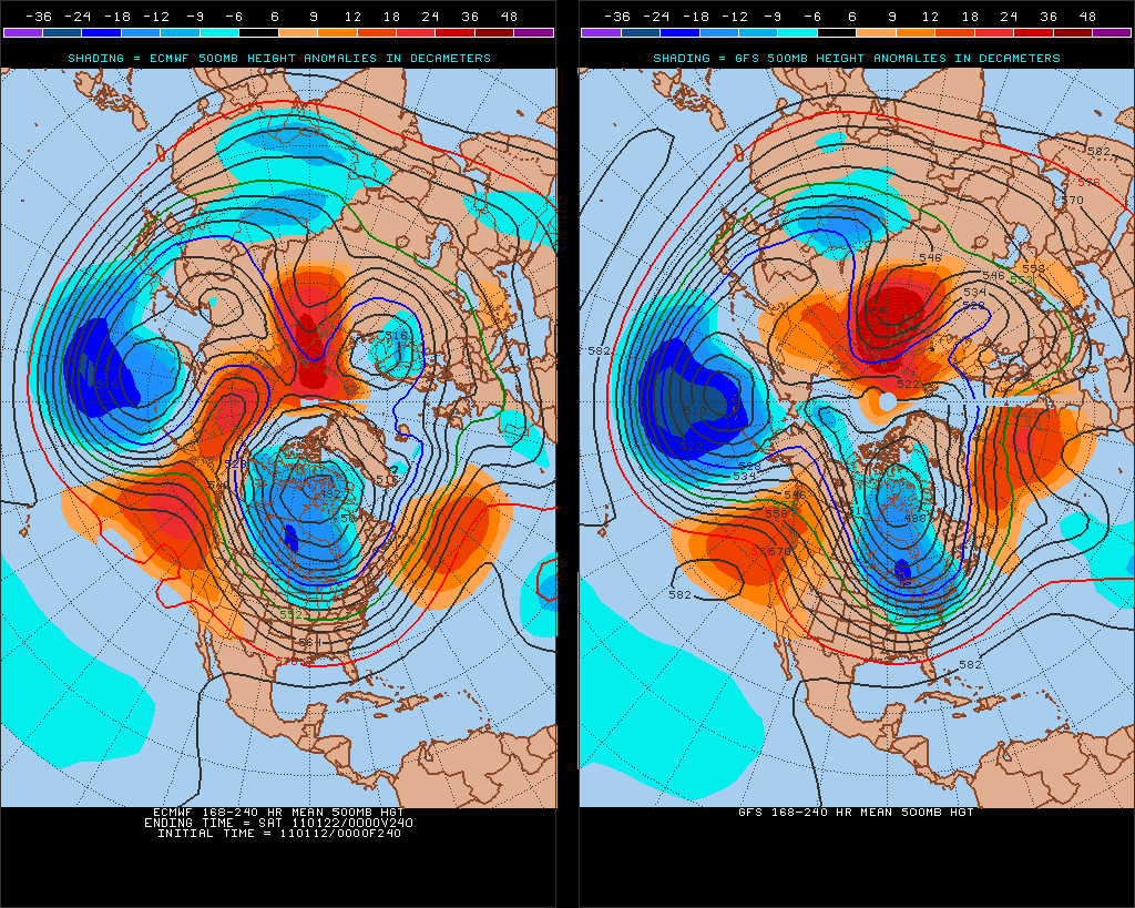
SIGNIFICANT DIFFERENCES CONTINUE BETWEEN THE ECMWF/GFS FOR THE LONG
TERM PERIODS. HOWEVER...THE ECMWF IS TRENDING TOWARD THE GFS DURING
THE LATER PORTION OF THE EXTENDED PERIODS...WHEN ANOTHER SIGNIFICANT
ARCTIC OUTBREAK INTO THE EASTERN U.S. APPEARS LIKELY.
FOR
TUE-WED...PREFER THE GFS SCENARIO WITH THE MAIN AXIS OF THE UPPER
TROUGH SHIFTING EAST OF THE AREA BY EARLY WED. THUS...RAIN WILL
CONTINUE ACROSS THE CWA TUE...SHIFTING EAST TUE NIGHT/EARLY WED. A
WEDGE WILL REMAIN IN PLACE EARLY TUE...BUT SHOULD ERODE FROM ALL
EXCEPT POSSIBLY THE NE COUNTIES BY TUE AFTERNOON. TUE SHOULD OFFER
THE WARMEST TEMPS TO THE REGION WE HAVE SEEN IN SOME TIME...BUT
CLOUD COVER AND RAIN WILL LIKELY KEEP IT COOLER THAN IT WOULD
OTHERWISE BE. ONLY MODEST COOLING IS EXPECTED FOR WED AS A MODIFIED
CANADIAN HIGH MOVES ACROSS THE REGION. BY THU...A STRONG SHORT WAVE
IS PROGGED TO MOVE QUICKLY FROM THE ROCKIES TOWARD THE TENNESSEE
VALLEY IN THE PREDOMINATE NW FLOW ALOFT. THIS WILL HERALD THE
BEGINNING OF A SIGNIFICANT SURGE OF ARCTIC AIR INTO THE EASTERN U.S.
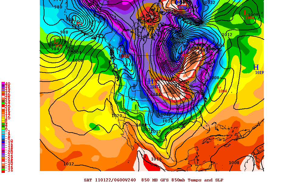
AS NOTED YESTERDAY...THE SOURCE OF THIS AIR MASS IS CURRENTLY
LOCATED ACROSS RUSSIA...AND TRAVELS ACROSS THE N POLE AND INTO THE
EASTERN U.S. THE CORE OF THIS AIR CONTINUES TO SHOW 850MB TEMPS NEAR
-40C. THIS COLD OUTBREAK MAY RIVAL THE 12-13 DEC COLD OUTBREAK AS
850MB TEMPS APPROACH -18C ACROSS N GA TO -10C ACROSS CENTRAL GA.HOWEVER...IT WILL PROBABLY NOT LAST AS LONG AS UPSTREAM SHORT WAVE
ENERGY KICKS THE DEEPEST COLD AIR OUT WITHIN A COUPLE OF DAYS. HAVE
UNDERCUT THE MEX MOS CONSIDERABLY FOR THE FRI-SAT PERIOD...GIVEN
HISTORY OF SUCH EVENTS THIS WINTER WITH SIMILAR 850MB PROGGED TEMPS.
GUIDANCE TENDING WAY TOO MUCH TOWARD CLIMATOLOGY AND NOT PROPERLY
ACCOUNTING FOR THE MAGNITUDE OF THIS COLD AIR. STRONG WINDS WILL
ALSO RESULT IN SIGNIFICANT WIND CHILLS THU NIGHT/FRI MORNING.
0 likes   
NEVER, EVER SAY NEVER in the tropics and weather in general, and most importantly, with life itself!!

________________________________________________________________________________________

Fay 2008 Beryl 2012 Debby 2012 Colin 2016 Hermine 2016 Julia 2016 Matthew 2016 Irma 2017 Dorian 2019

User avatar
Suncat
Tropical Storm
Tropical Storm
Posts: 139
Joined: Wed Jan 01, 2003 6:10 pm
Location: Cary, NC

Re: Siberian Express January 2011

#180 Postby Suncat » Sat Jan 15, 2011 2:53 pm

While the models are starting to point to significant cold air dropping south, what do the potential precipitation amounts look like?

BTW, the Old Farmer's Almanac for the Southeast Region (Southern VA to Georgia) calls for a snowstorm in the north and rain to snow in the south, turning very cold for January 18 - 25. We'll see. :wink:
0 likes   


Return to “Winter Weather”

Who is online

Users browsing this forum: No registered users and 207 guests