Texas Winter 2022-2023

Winter Weather Discussion

Moderator: S2k Moderators

Forum rules

The posts in this forum are NOT official forecast and should not be used as such. They are just the opinion of the poster and may or may not be backed by sound meteorological data. They are NOT endorsed by any professional institution or STORM2K.

Help Support Storm2K
Message
Author
orangeblood
S2K Supporter
S2K Supporter
Posts: 3334
Joined: Tue Dec 15, 2009 6:14 pm
Location: Fort Worth, TX

Re: Texas Winter 2022-2023

#5321 Postby orangeblood » Mon Jan 30, 2023 4:25 pm

Ntxw wrote:
orangeblood wrote:
txtwister78 wrote:
I still think those Wednesday highs are too cold, but we shall see. A lot of low 40's showing up across Panhandle on Wed afternoon so no question about the moderation/"warming" trend at that point. Might be keeping temps just below freezing as a result of sleet accumulation. That would spare DFW the worst onslaught of freezing rain if that's off/too cold. Fingers crossed for some family up there. Definitely not rooting for the extreme.


Check out the surface wind field though...Panhandle warming due to downsloping west wind direction, North Texas maintains cold advection out of the North thru Thursday. It's relentless and what makes this cold air pocket unique/something you don't see that often. The cold dome is literally stuck over the state and doesn't erode until west wind kicks in on Friday


Temperature inversion. They can be stubborn. You can recall a couple days ago even with the change in tune, a little below freezing was the idea. Yet we have been in the danger range 27-28 all day. That's not a little bit of freezing temps.


Yep, I'm still puzzled by the continued chasing of temps by some of these forecast offices/news outlets. Stop chasing and using computer output/start putting a little human touch into these forecasts and get out ahead of it....cut by 2-3 Deg F at least within this established cold dome and go from there!
4 likes   

Ntxw
Storm2k Moderator
Storm2k Moderator
Posts: 21511
Joined: Wed Oct 21, 2009 6:34 pm
Location: DFW, Texas

Re: Texas Winter 2022-2023

#5322 Postby Ntxw » Mon Jan 30, 2023 4:28 pm

DallasAg wrote:Looks like maybe things are winding down a bit? The steady fetch of convection to the SW of the metroplex has dried up to a degree. Folks W, NW, N, and NE of the metroplex still have a few hours for this wave to pass.

Are we thinking freezing drizzle takes over for a while before the big event or all dry and a chance for some drying/sublimation?


It should wind down some. FW put out a good discussion of what expect and sounds pretty well done. 900-800mb front placement tomorrow will determine the 'zone'. Today it was a little NW of the immediate core of DFW through the NW areas. Tomorrow a little further south and east.

Image

Area Forecast Discussion
National Weather Service Fort Worth TX
317 PM CST Mon Jan 30 2023

...New Long Term...

.SHORT TERM... /Issued 139 PM CST Mon Jan 30 2023/
/This Afternoon through Wednesday/

Our winter storm is unfolding this afternoon with areas of
freezing rain and thunderstorms with heavy sleet ongoing across
parts of North Texas. The activity this afternoon is tied to a
weak impulse in the southwest flow aloft and strong 900-800 mb
frontogenesis across the northwest half of the CWA. Observed and
forecast soundings indicate that around 400 J/kg of instability is
available to parcels atop the frontal inversion. With strong
ascent, this is supporting thunderstorms across a good portion of
the region. Heavy sleet has been reported in many areas and this
trend will continue through the afternoon. The band of ascent will
make steady progress north and east by evening and we should see a
gradual shift eastward to the precipitation. Temperatures will
remain in the mid/upper 20s which means that heavy freezing rain
and sleet will quickly turn to ice on area bridges and overpasses.
Untreated surface roads may also become icy in a short period of
time. As the precipitation shifts east and diminishes in intensity
this evening, we`ll likely see a little lull in overall activity,
but this should be short lived as we remain within a broad area of
ascent through the overnight hours. Light freezing rain should
develop again after midnight and spread northward through the
morning hours. With little change in the atmospheric profile
expected, pockets of convection will again be possible during the
day Tuesday, although the axis of heaviest precipitation may shift
a bit to the southeast along the 900-800 mb front. Widespread
freezing rain/sleet is expected again Tuesday night into
Wednesday.

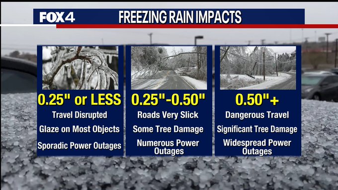
Total ice accumulations still look like they`ll be around 1/4" for
most areas (sleet is excluded from ice accums - it`s counted as
snow) although some pockets of heavier ice accumulations will be
possible through early Wednesday. Sleet accumulations could
approach 1" in the heaviest bursts, however most of this has been
around 1/4-1/2" before melting some.

We`ll be extending the Winter Storm Warning through midday
Wednesday with this issuance.

Dunn
1 likes   
The above post and any post by Ntxw is NOT an official forecast and should not be used as such. It is just the opinion of the poster and may or may not be backed by sound meteorological data. It is NOT endorsed by any professional institution including Storm2k. For official information, please refer to NWS products.

  Help support Storm2K!
Help Support Storm2K

orangeblood
S2K Supporter
S2K Supporter
Posts: 3334
Joined: Tue Dec 15, 2009 6:14 pm
Location: Fort Worth, TX

Re: Texas Winter 2022-2023

#5323 Postby orangeblood » Mon Jan 30, 2023 4:30 pm

rwfromkansas wrote:Temp dropping pretty rapidly now at 24. Did not expect this.

Thought we would be stable.


Continued strong cold advection from the north, now flowing over a frozen ground from the precip! It becomes a feedback loop under these temp inversions that is difficult to model
4 likes   

orangeblood
S2K Supporter
S2K Supporter
Posts: 3334
Joined: Tue Dec 15, 2009 6:14 pm
Location: Fort Worth, TX

Re: Texas Winter 2022-2023

#5324 Postby orangeblood » Mon Jan 30, 2023 4:34 pm

Ntxw wrote:
DallasAg wrote:Looks like maybe things are winding down a bit? The steady fetch of convection to the SW of the metroplex has dried up to a degree. Folks W, NW, N, and NE of the metroplex still have a few hours for this wave to pass.

Are we thinking freezing drizzle takes over for a while before the big event or all dry and a chance for some drying/sublimation?


It should wind down some. FW put out a good discussion of what expect and sounds pretty well done. 900-800mb front placement tomorrow will determine the 'zone'. Today it was a little NW of the immediate core of DFW through the NW areas. Tomorrow a little further south and east.


Probably not the only time they'll extend this Warning...maybe another 12-24 hrs to go!!!
2 likes   

Ralph's Weather
S2K Supporter
S2K Supporter
Posts: 2968
Age: 36
Joined: Fri Dec 13, 2013 11:55 am
Location: Lindale, TX

Re: Texas Winter 2022-2023

#5325 Postby Ralph's Weather » Mon Jan 30, 2023 4:38 pm

Oh NWS and using models to forecast. Temp in Tyler has held at 32 all day, but latest update actually increased the afternoon high today to 36 from 35. This almost 24hour freeze before the big event starts will be very impactful even if temps are borderline.
2 likes   
Follow on Facebook at Ralph's Weather.

orangeblood
S2K Supporter
S2K Supporter
Posts: 3334
Joined: Tue Dec 15, 2009 6:14 pm
Location: Fort Worth, TX

Re: Texas Winter 2022-2023

#5326 Postby orangeblood » Mon Jan 30, 2023 5:16 pm

Hey!! Look who showed up to the party…our old buddy Mr GFS. Although, I wouldn’t call this being fashionable late by any stretch

Image
Last edited by orangeblood on Mon Jan 30, 2023 5:54 pm, edited 1 time in total.
5 likes   

cstrunk
Category 1
Category 1
Posts: 493
Joined: Sat Jul 04, 2020 10:38 am
Location: Longview, TX

Re: Texas Winter 2022-2023

#5327 Postby cstrunk » Mon Jan 30, 2023 5:20 pm

Ralph's Weather wrote:Oh NWS and using models to forecast. Temp in Tyler has held at 32 all day, but latest update actually increased the afternoon high today to 36 from 35. This almost 24hour freeze before the big event starts will be very impactful even if temps are borderline.


Yeah SHV has been behind all event long so far. When I woke up today the predicted high for Longview was 42F. Later this morning they dropped it to 39F. It's currently 36F at the Longview airport (a good bit SE of town) and 34F at my house (north side of town). With the continued CAA over areas that are now sleet-covered to the north/northwest... there's a pretty good chance we end up colder than the 34F predicted low for tonight and 36F predicted high for tomorrow...
1 likes   

User avatar
bubba hotep
S2K Supporter
S2K Supporter
Posts: 5476
Joined: Wed Dec 28, 2016 1:00 am
Location: Collin County Texas

Re: Texas Winter 2022-2023

#5328 Postby bubba hotep » Mon Jan 30, 2023 5:21 pm

Image
1 likes   
Winter time post are almost exclusively focused on the DFW area.

rwfromkansas
Category 5
Category 5
Posts: 2179
Joined: Sat Aug 27, 2005 12:47 am
Location: North Fort Worth

Re: Texas Winter 2022-2023

#5329 Postby rwfromkansas » Mon Jan 30, 2023 5:22 pm

Well now my temp is jumping to 27.

Weird.
1 likes   

Ntxw
Storm2k Moderator
Storm2k Moderator
Posts: 21511
Joined: Wed Oct 21, 2009 6:34 pm
Location: DFW, Texas

Re: Texas Winter 2022-2023

#5330 Postby Ntxw » Mon Jan 30, 2023 5:27 pm

Southeast US won't notice a thing. 50s/60s/70s the whole way from New Orleans to Atlanta...what cold air?

Image
1 likes   
The above post and any post by Ntxw is NOT an official forecast and should not be used as such. It is just the opinion of the poster and may or may not be backed by sound meteorological data. It is NOT endorsed by any professional institution including Storm2k. For official information, please refer to NWS products.


  Help support Storm2K!

Help Support Storm2K


Ralph's Weather
S2K Supporter
S2K Supporter
Posts: 2968
Age: 36
Joined: Fri Dec 13, 2013 11:55 am
Location: Lindale, TX

Re: Texas Winter 2022-2023

#5331 Postby Ralph's Weather » Mon Jan 30, 2023 5:32 pm

cstrunk wrote:Yeah SHV has been behind all event long so far. When I woke up today the predicted high for Longview was 42F. Later this morning they dropped it to 39F. It's currently 36F at the Longview airport (a good bit SE of town) and 34F at my house (north side of town). With the continued CAA over areas that are now sleet-covered to the north/northwest... there's a pretty good chance we end up colder than the 34F predicted low for tonight and 36F predicted high for tomorrow...

They have Lindale at 31/33 for tomorrow, a couple degrees lower and impacts are very different on the roads.
0 likes   
Follow on Facebook at Ralph's Weather.

harp
Category 2
Category 2
Posts: 517
Joined: Mon Dec 31, 2018 12:01 am
Location: South Louisiana

Re: Texas Winter 2022-2023

#5332 Postby harp » Mon Jan 30, 2023 5:35 pm

Ntxw wrote:Southeast US won't notice a thing. 50s/60s/70s the whole way from New Orleans to Atlanta...what cold air?

https://i.imgur.com/maeIdmu.png

Tell me about it!! I hit 80 today at my house. It just wasn’t our turn. Hopefully, we have another shot before winter is over. That damned SE ridge….
1 likes   

User avatar
Cerlin
Category 5
Category 5
Posts: 1177
Age: 22
Joined: Thu Dec 08, 2016 12:06 am
Location: Norman, OK

Re: Texas Winter 2022-2023

#5333 Postby Cerlin » Mon Jan 30, 2023 5:38 pm

Image Got a pretty substantial glaze of ice and sleet at the National Weather Center so far!
6 likes   
Undergraduate Meteorology Student at the University of Oklahoma and Operator at the Oklahoma Mesonet.
All opinions independent of employers and the university.

gpsnowman
S2K Supporter
S2K Supporter
Posts: 2716
Joined: Fri Jan 07, 2011 10:35 am
Location: Grand Prairie Tx

Re: Texas Winter 2022-2023

#5334 Postby gpsnowman » Mon Jan 30, 2023 5:46 pm

What time are we looking at the next round? Thinking of setting the alarm if it comes early enough.
BTW got a nice little flizzard right now.
2 likes   

User avatar
Iceresistance
Category 5
Category 5
Posts: 8915
Age: 20
Joined: Sat Oct 10, 2020 9:45 am
Location: Tecumseh, OK/Norman, OK

Re: Texas Winter 2022-2023

#5335 Postby Iceresistance » Mon Jan 30, 2023 5:48 pm

The High for me was only 21°F
2 likes   
Bill 2015 & Beta 2020

Winter 2020-2021 :cold:

All observations are in Tecumseh, OK unless otherwise noted.

Winter posts are focused mainly for Oklahoma & Texas.

Take any of my forecasts with a grain of salt, refer to the NWS, SPC, and NHC for official information

Never say Never with weather! Because ANYTHING is possible!

orangeblood
S2K Supporter
S2K Supporter
Posts: 3334
Joined: Tue Dec 15, 2009 6:14 pm
Location: Fort Worth, TX

Re: Texas Winter 2022-2023

#5336 Postby orangeblood » Mon Jan 30, 2023 5:56 pm

gpsnowman wrote:What time are we looking at the next round? Thinking of setting the alarm if it comes early enough.
BTW got a nice little flizzard right now.


Looks like around 6-7am widespread showers should start moving thru Metroplex from the southwest
3 likes   

gpsnowman
S2K Supporter
S2K Supporter
Posts: 2716
Joined: Fri Jan 07, 2011 10:35 am
Location: Grand Prairie Tx

Re: Texas Winter 2022-2023

#5337 Postby gpsnowman » Mon Jan 30, 2023 5:58 pm

orangeblood wrote:
gpsnowman wrote:What time are we looking at the next round? Thinking of setting the alarm if it comes early enough.
BTW got a nice little flizzard right now.


Looks like around 6-7am widespread showers should start moving thru Metroplex from the southwest

Gracias. 6am it is then. The daughter and I both have an off day.
1 likes   

User avatar
txtwister78
Category 5
Category 5
Posts: 1011
Joined: Wed Jan 30, 2019 12:56 pm
Location: San Antonio

Re: Texas Winter 2022-2023

#5338 Postby txtwister78 » Mon Jan 30, 2023 6:02 pm

Wow. Another insane model output. Crippling freezing rain accumulations per the RAP extended from SA to Austin corridor points east of I-35 across central TX. No question regardless of whether these are correct or not (RAP, RGEM), main event looks to be tomorrow late afternoon stretching into Wednesday morning.

Image
1 likes   

User avatar
Iceresistance
Category 5
Category 5
Posts: 8915
Age: 20
Joined: Sat Oct 10, 2020 9:45 am
Location: Tecumseh, OK/Norman, OK

Re: Texas Winter 2022-2023

#5339 Postby Iceresistance » Mon Jan 30, 2023 6:03 pm

My School is virtual today, and so are Bethel, Shawnee, and Asher Schools. Who decided that today was a good day to be in-person.
1 likes   
Bill 2015 & Beta 2020

Winter 2020-2021 :cold:

All observations are in Tecumseh, OK unless otherwise noted.

Winter posts are focused mainly for Oklahoma & Texas.

Take any of my forecasts with a grain of salt, refer to the NWS, SPC, and NHC for official information

Never say Never with weather! Because ANYTHING is possible!

User avatar
Edwards Limestone
S2K Supporter
S2K Supporter
Posts: 339
Age: 34
Joined: Tue Dec 28, 2021 11:05 am
Location: Smithson Valley, TX

Re: Texas Winter 2022-2023

#5340 Postby Edwards Limestone » Mon Jan 30, 2023 6:05 pm

txtwister78 wrote:Wow. Another insane model output. Crippling freezing rain accumulations per the RAP extended from SA to Austin corridor points east of I-35 across central TX. No question regardless of whether these are correct or not (RAP, RGEM), main event looks to be tomorrow late afternoon stretching into Wednesday morning.

https://m2o.pivotalweather.com/maps/models/rap/2023013021/051/zr_acc-imp.us_sc.png


Looking similar to that 18z HRRR run but worse....look out
3 likes   
The above post is NOT an official forecast and should not be used as such. It is just the opinion of the poster and may or may not be backed by sound meteorological data. It is NOT endorsed by any professional institution including Storm2k. For official information, please refer to NWS products.


Return to “Winter Weather”

Who is online

Users browsing this forum: Google Adsense [Bot] and 193 guests