12/25-27 Snowfall: Great Lakes/Ontario

Winter Weather Discussion

Moderator: S2k Moderators

Forum rules

The posts in this forum are NOT official forecast and should not be used as such. They are just the opinion of the poster and may or may not be backed by sound meteorological data. They are NOT endorsed by any professional institution or STORM2K.

Help Support Storm2K
Message
Author
donsutherland1
S2K Analyst
S2K Analyst
Posts: 2718
Joined: Mon Sep 15, 2003 8:49 pm
Location: New York

12/25-27 Snowfall: Great Lakes/Ontario

#1 Postby donsutherland1 » Fri Dec 22, 2006 9:52 pm

Since December 12, the NCEP ensemble 500 mb anomalies have suggested some similarity to the December 19-21, 1974 period that saw snow blanket parts of the Great Lakes region and Ontario.

Then, the NCEP ensemble mean 500 mb anomalies for 12/25 0z were:
Image

The latest NCEP ensemble mean 500 mb anomalies for 12/26 0z are:
Image

The 500 mb anomalies for 12/21/1974 were:
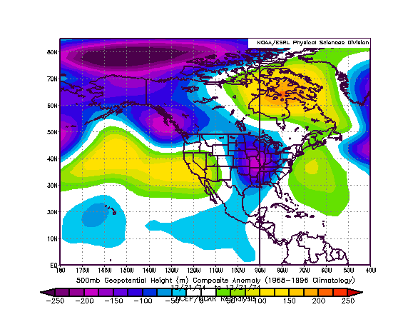
Image

The 12/18-21/1974 period saw the following snowfall totals for select cities.

Chicago: 4.1"
Des Moines: 3.8"
Detroit: 6.4"
Indianapolis: 2.6"
Milwaukee: 7.5"
Windsor: 6.5" (16.5 cm)

At last word, the major features are somewhat farther to the south and east on the ensemble mean than they were on 12/12. Considering also the 12z ECMWF and GFS and the 18z GFS, I believe the highest potential for accumulating snow will involve an area across parts of Indiana, eastern Michigan, western Ohio, and parts of Ontario (including Windsor and London). In this area, I believe some locations could see several inches of snow (initially, 2"-4" seems reasonable with a few spots picking up a little more).

Eastern Ohio, western Pennsylvania, and southern Ontario, including snow-starved Toronto, should see at least a little snow as the storm heads away. There is a chance that Toronto could pick up several centimeters of snow.
0 likes   

User avatar
tomboudreau
Category 5
Category 5
Posts: 1869
Age: 48
Joined: Tue Feb 18, 2003 6:07 pm
Location: Carnegie, PA
Contact:

#2 Postby tomboudreau » Sat Dec 23, 2006 8:35 pm

Hey Don...any ideas on totals yet on this system? Just curious. Got to go to work for 4:30 AM on Tuesday morning, and I'm just wondering what kind of travel conditions I can expect. Are we looking at advisory level or warning level snows? Thanks for any update. Have a Merry Christmas.
0 likes   

lwg8tr01
Tropical Wave
Tropical Wave
Posts: 4
Joined: Mon Dec 11, 2006 7:12 am

Depends

#3 Postby lwg8tr01 » Sun Dec 24, 2006 7:03 am

tomboudreau wrote:Hey Don...any ideas on totals yet on this system? Just curious. Got to go to work for 4:30 AM on Tuesday morning, and I'm just wondering what kind of travel conditions I can expect. Are we looking at advisory level or warning level snows? Thanks for any update. Have a Merry Christmas.


Saw some METS on Accuweather looking at the model runs last night and it's still up in the air when it comes to accumulation. The GFS shows a rain event to begin with then some accumulation like 1-2" in Western PA. That opinion by the way I don't agree with and it's looking a little less likely we'll get off that easy. Looking more like the EURO which has a low bombing out over New England Christmas night and Western PA, WV, Ohio being on the backside and getting dumped on. That mean upper elevations getting up to a foot with Pittsburgh getting more like 4-6 inches.
0 likes   


Return to “Winter Weather”

Who is online

Users browsing this forum: No registered users and 7 guests