Eastern U.S.: Furnace-like Days for Early October?

U.S. & Caribbean Weather Discussions and Severe Weather Events

Moderator: S2k Moderators

Forum rules

The posts in this forum are NOT official forecast and should not be used as such. They are just the opinion of the poster and may or may not be backed by sound meteorological data. They are NOT endorsed by any professional institution or STORM2K.

Help Support Storm2K
Message
Author
donsutherland1
S2K Analyst
S2K Analyst
Posts: 2718
Joined: Mon Sep 15, 2003 8:49 pm
Location: New York

Eastern U.S.: Furnace-like Days for Early October?

#1 Postby donsutherland1 » Mon Sep 26, 2005 9:05 am

Unfortunately, for cool weather lovers, it appears that Nature could be stoking up the furnace for one more time in early October. Previously, DT had mentioned the return of the Pacific jet and the likelihood of a warm October (something with which I agree).

The model guidance is now very bullish on a spell of above to much above normal temperatures in the eastern U.S. beginning by next weekend (weekend of 10/2-3). The potential exists for at least a day or two of extreme heat relative to the season.

Select 850 mb Temperatures per the 9/26 0z run of the ECMWF:
Boston:
10/2 0z: 12.9C
10/3 0z: 16.3C

New York City:
10/2 0z: 14.0C
10/3 0z: 16.7C

Philadelphia:
10/2 0z: 14.6C
10/3 0z: 16.6C

Richmond:
10/2 0z: 12.8C
10/3 0z: 16.2C

Washington, DC:
10/2 0z: 13.6C
10/3 0z: 15.8C

For those two days, the ECMWF suggests that cloud cover could be low. So, the mercury should be off to the races, particularly on Sunday.

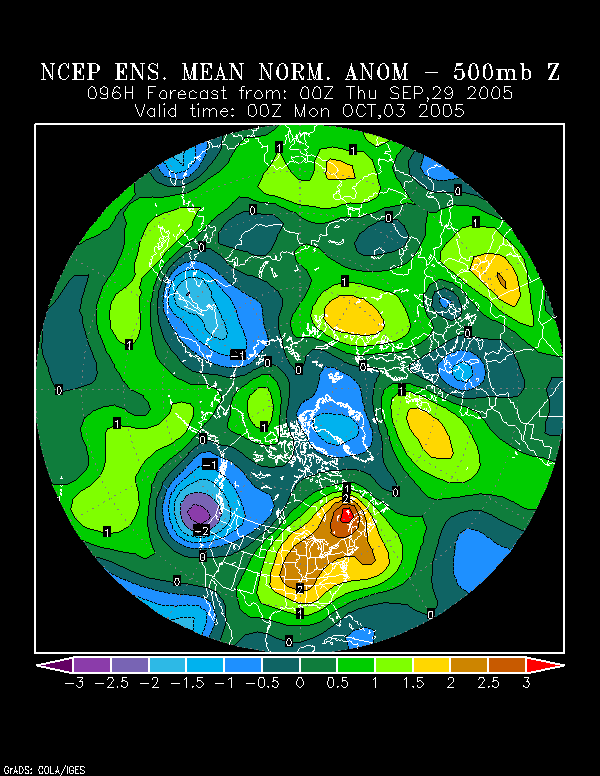
The NCEP Ensemble Anomaly is very impressive for 10/3 0z. In fact, with the core of the anomalous heat focused on New England, if a west wind were to sweep into Boston, the temperature could well challenge or beat the all-time monthly record of 90° for that city established on several dates. It's still a little soon to have high confidence in that idea, but it might be something to watch for. And depending on how the season-ending series goes between the Red Sox and Yankees, the heat could prove especially hellish, especially if the Cleveland Indians hang on to win the American League wild card spot.

NCEP 500 mb Anomalies:
Image

ECMWF vs. GFS 8-10-Day 500 mb Means:
Image

The NCEP Ensemble anomalies seem to more closely resemble the 8-10 Day ECMWF 500 mb mean.

Records for Select Cities:
Boston:
10/2 88, 1954
10/3 85, 1922
10/4 85, 1983

October record: 90, 10/1/1881, 10/7/1963, and 10/12/1954

New York City:
10/2 90, 1927
10/3 87, 1919
10/4 88, 1941

October record: 94, 10/5/1941

Philadelphia:
10/2 87, 2002
10/3 90, 1919
10/4 88, 1941

October record: 96, 10/5/1941

Richmond:
10/2 91, 1986
10/3 94, 1919
10/4 94, 1986

October record: 99, 10/6/1941

Washington, DC:
10/2 89, 1986
10/3 92, 1879
10/4 94, 1954

October record: 96, 10/5/1941

At this point in time, I have sufficient confidence that at least some record highs will fall in the 10/2-4 period. Moreover, I believe Richmond and Washington, DC will break 90° on at least one occasion and that potential extends into New England if everything comes together.

The most extreme outbreak of October heat occurred in 1941. Just for fun and not forecasting purposes--at least hopefully this won't prove to be my winter idea--Winter 1941-42 proved very disappointing in the East in terms of seasonal snowfall. Essentially, in terms of snowfall, winter was confined to a single month--March 1942:

Boston: 24.0"
New York City: 11.3"
Philadelphia: 9.8"
Washington, DC: 13.6"

Needless to say, there were some highlights:

∙ March 2-3, 1942: 19.3" snowfall in Cedartown, GA
∙ March 29-30, 1942: Washington, DC was buried under 12" of snow and Baltimore picked up 22".

In conclusion, "true summer" returned to the East in a big way this year. Now, even as the calendar has moved into Autumn when the leaves, acorns and temperatures should be falling, Summer appears reluctant to depart.
0 likes   

User avatar
CaptinCrunch
S2K Supporter
S2K Supporter
Posts: 8728
Age: 57
Joined: Mon Nov 03, 2003 4:33 pm
Location: Kennedale, TX (Tarrant Co.)

#2 Postby CaptinCrunch » Mon Sep 26, 2005 9:24 am

Summer will indeed hang on for a few more weeks, I don't see much of a true Fall cool down till mid October for the East or South. :cry:
0 likes   

User avatar
Stephanie
S2K Supporter
S2K Supporter
Posts: 23843
Age: 63
Joined: Thu Feb 06, 2003 9:53 am
Location: Glassboro, NJ

#3 Postby Stephanie » Mon Sep 26, 2005 9:34 am

Warmth is okay - HOT is not!!!

Actually, Ma Nature maybe doing us a favor by having us delay turning on the heater.
0 likes   

User avatar
angelwing
S2K Supporter
S2K Supporter
Posts: 4462
Age: 64
Joined: Tue Jan 18, 2005 3:06 pm
Location: Kulpsville, PA

#4 Postby angelwing » Mon Sep 26, 2005 11:40 am

With the weather up here, I see a jump from Summer right into Winter, no fall to be had. If I remember correctly, the last few years, we had maybe 2 days of spring-like weather, then bam the heat was on.
0 likes   

Steve Carpenter
Tropical Low
Tropical Low
Posts: 16
Joined: Tue Sep 20, 2005 9:45 am
Location: Asheville, North Carolina

#5 Postby Steve Carpenter » Mon Sep 26, 2005 6:28 pm

Hey Donald -

I'm curious to see if your willing to gaze into your crystal ball. We've booked our annual ski trip for mid-January at Steamboat. What's the winter prognosis for the Central Rockies?

No pressure.....we're already booked....so we can't blame you!
0 likes   

donsutherland1
S2K Analyst
S2K Analyst
Posts: 2718
Joined: Mon Sep 15, 2003 8:49 pm
Location: New York

#6 Postby donsutherland1 » Mon Sep 26, 2005 9:03 pm

Steve Carpenter,

By mid-October, I'll post my winter thoughts. I'm just looking at possible analogs right now and will need the September data to help screen them. It's a little too soon for me to venture an estimate just yet.

Best wishes.
0 likes   

AnthonyC
Category 2
Category 2
Posts: 734
Joined: Fri Jan 07, 2005 4:38 pm

#7 Postby AnthonyC » Mon Sep 26, 2005 9:27 pm

Don,

I'm assuming with a significant ridge in the east, there's a significant trough in the west? What are you seeing for the PNW? Significant rainfall in the next week or so?

Anthony
0 likes   

donsutherland1
S2K Analyst
S2K Analyst
Posts: 2718
Joined: Mon Sep 15, 2003 8:49 pm
Location: New York

Re: Eastern U.S.: Furnace-like Days for Early October?

#8 Postby donsutherland1 » Tue Sep 27, 2005 8:46 am

Another day and both the NCEP ensemble mean and ECMWF (9/27 0z) continue to point to a significant warmup, with Sunday-Monday possibly seeing the warmest readings:

Comparison of 850 mb Temperatures per the 9/26 0z and 9/27 0z runs of the ECMWF:
Boston:
10/2 0z: 9/26 run: 12.9C; 9/27 run: 12.6C
10/3 0z: 9/26 run: 16.3C; 9/27 run: 15.9C

New York City:
10/2 0z: 9/26 run: 14.0C; 9/27 run: 13.4C
10/3 0z: 9/26 run: 16.7C; 9/27 run: 15.5C

Philadelphia:
10/2 0z: 9/26 run: 14.6C; 9/27 run: 13.6C
10/3 0z: 9/26 run: 16.6C; 9/27 run: 15.6C

Richmond:
10/2 0z: 9/26 run: 12.8C; 9/27 run: 13.5C
10/3 0z: 9/26 run: 16.2C; 9/27 run: 14.4C

Washington, DC:
10/2 0z: 9/26 run: 13.6C; 9/27 run: 13.6C
10/3 0z: 9/26 run: 15.8C' 9/27 run: 14.7C

9/27 0z ECMWF Forecast for 10/4 0z:
Boston: 14.7C
New York City: 15.2C
Philadelphia: 15.7C
Richmond: 15.4C
Washington, DC: 15.4C

The GFS is less impressed with the magnitude of the coming warmth. For now, I continue to believe that all the above cities should reach or exceed 80° at the height of the warmth. Conservatively, I believe the highest temperatures for each of the above cities will fall into the following ranges and I include the MOS (MEX) figures for purposes of comparison:

Boston: 78-83 (MOS: 73)
New York City: 80-85 (MOS: 77)
Philadelphia: 82-87 (MOS: 78)
Richmond: 85-90 (MOS: 82)
Washington, DC: 83-88 (MOS: 81)

Right now, I still cannot rule out the more extreme scenario, but will err on the side of conservatism. It's still possible for somewhat cooler readings as per the operational GFS, but I'm inclined to believe right now that the warmer one is more likely.
0 likes   

donsutherland1
S2K Analyst
S2K Analyst
Posts: 2718
Joined: Mon Sep 15, 2003 8:49 pm
Location: New York

Re: Eastern U.S.: Furnace-like Days for Early October?

#9 Postby donsutherland1 » Wed Sep 28, 2005 9:06 am

Another day has passed and the European Model (9/28 0z), NCEP ensemble mean, and Canadian ensembles all strongly signal warmth. One would reasonably expect that the MOS, which is weighted for climatology in its extended range, would increasingly be dancing to the warmer tune. Not at all.

As a result, the way things currently stand, either the MOS or I are headed for a train wreck early next week with regard to the height of the coming warmth.

My estimates for the highest tempertures for early next week (likely to occur in the Sunday-Monday timeframe ), which remain unchanged from yesterday, are below along with the MOS (MEX) estimates and the change in the MOS estimate from yesterday:

Boston: 78-83 (MOS: 76: +3° from yesterday)
New York City: 80-85 (MOS: 78: +1° from yesterday)
Philadelphia: 82-87 (MOS: 79: +1° from yesterday)
Richmond: 85-90 (MOS: 79: -3° from yesterday)
Washington, DC: 83-88 (MOS: 77: -4° from yesterday)

ECMWF:

Comparison of 850 mb Temperatures per the 9/26 0z, 9/27 0z, and 9/28 0z runs of the ECMWF:
Boston:
10/2 0z: 9/26 run: 12.9C; 9/27 run: 12.6C; 9/28 run: 12.8C
10/3 0z: 9/26 run: 16.3C; 9/27 run: 15.9C; 9/28 run: 15.6C
10/4 0z: 9/27 run: 14.7C; 9/28 run: 13.8C

New York City:
10/2 0z: 9/26 run: 14.0C; 9/27 run: 13.4C; 9/28 run: 14.2C
10/3 0z: 9/26 run: 16.7C; 9/27 run: 15.5C; 9/28 run: 15.8C
10/4 0z: 9/27 run: 15.2C; 9/28 run: 14.5C

Philadelphia:
10/2 0z: 9/26 run: 14.6C; 9/27 run: 13.6C; 9/28 run: 14.6C
10/3 0z: 9/26 run: 16.6C; 9/27 run: 15.6C; 9/28 run: 15.8C
10/4 0z: 9/27 run: 15.7C; 9/28 run: 15.0C

Richmond:
10/2 0z: 9/26 run: 12.8C; 9/27 run: 13.5C; 9/28 run: 14.5C
10/3 0z: 9/26 run: 16.2C; 9/27 run: 14.4C; 9/28 run: 14.1C
10/4 0z: 9/27 run: 15.4C; 9/28 run: 15.7C

Washington, DC:
10/2 0z: 9/26 run: 13.6C; 9/27 run: 13.6C; 9/28 run: 14.2C
10/3 0z: 9/26 run: 15.8C; 9/27 run: 14.7C; 9/28 run: 14.6C
10/4 0z: 9/27 run: 15.4C; 9/28 run: 15.0C

Canadian Ensembles: 10-Day Outlook from 9/28 0z:
Image

In eastern Canada, one finds a large area of warmth that is 1 to 1.5 standard deviations above normal once one converts the units (each of which is the equivalent of 0.43 standard deviations).

NCEP Ensembles:
Image

One finds an expansive area of 1.5 standard deviation or above normal 500 mb height anomalies in the Mid-Atlantic and Northeast.

Although cooler air could push into the East later Tuesday or Wednesday, I believe any cool air masses will be transient through next week. The 8-10 day mean anomalies for both the GFS and ECMWF show above to much above normal heights.

Finally, while Summer 2005 attempts to stage a counterattack against the slowly advancing forces of autumn, the look way back into the past shows that this has not always been the case. Occasionally, winter has held the upper hand. On this date in 1836, parts of northern New England experienced an accumulating snowfall. The following article, which first appeared in the Keene Sentinel, was published in the October 8, 1836 issue of the Connecticut Courant:

A gentleman who passed through Stratford, (Vt.) on Wednesday last, Sept. 28, brought a snow ball as far as this town which he collected on that day;--the ground was covered. The hills in New Ipswich, (N.H.) Ashburnham and Fitzwilliam were also white. The "oldest people" do not remember snow in September before.
0 likes   

donsutherland1
S2K Analyst
S2K Analyst
Posts: 2718
Joined: Mon Sep 15, 2003 8:49 pm
Location: New York

Re: Eastern U.S.: Furnace-like Days for Early October?

#10 Postby donsutherland1 » Wed Sep 28, 2005 3:27 pm

Brief additional thoughts on coming warmth...

1) 9/28 12z Euro holds serve: maintains idea of 850 mb temperatures reaching generally 15C +/- 1C for the period in question.

2) The 9/28 12z MOS gives ground. Its forecast for the highest temperatures during the warm spell likely to peak in the Sunday-Monday period:

Boston: 78° +2° from 9/28 0z
New York City: 81° +3° from 9/28 0z
Philadelphia: 82° +3° from 9/28 0z
Richmond: 85° +6° from 9/28 0z
Washington, DC: 82° +5° from 9/28 0z

The MOS has now moved into the low part of my estimates for Boston, New York City, Philadelphia, and Richmond. It is still just below my range for Washington, DC.
0 likes   

donsutherland1
S2K Analyst
S2K Analyst
Posts: 2718
Joined: Mon Sep 15, 2003 8:49 pm
Location: New York

#11 Postby donsutherland1 » Thu Sep 29, 2005 8:25 am

Things are slowly converging on the idea of a bout of much above normal temperatures for early next week, possibly peaking in the Sunday-Monday timeframe. The 9/28 12z MOS took a big step in that direction and teh 9/29 0z MOS did not retreat.

In the meantime, the NCEP ensemble mean has increased its estimate of the above normal height anomalies to 2 standard deviations over a large area that covers a portion of the Mid-Atlantic and Northeast:

Image

The 9/29 0z Euro has nudged its estimates up in the Mid-Atlantic where it now takes the 10/3 0z reading at Richmond to 16.1C.

My estimates for the highest tempertures for early next week (likely to occur in the Sunday-Monday timeframe ) and the latest MOS (MEX) estimates:

Boston: 78-83 (MOS: 78)
New York City: 80-85 (MOS: 81)
Philadelphia: 82-87 (MOS: 82)
Richmond: 85-90 (MOS: 85)
Washington, DC: 83-88 (MOS: 82)

ECMWF:

Comparison of 850 mb Temperatures per the 9/26 0z, 9/27 0z, 9/28 0z, and 9/29 0z runs of the ECMWF:
Boston:
10/2 0z: 9/26 run: 12.9C; 9/27 run: 12.6C; 9/28 run: 12.8C; 9/29 run: 13.7C
10/3 0z: 9/26 run: 16.3C; 9/27 run: 15.9C; 9/28 run: 15.6C; 9/29 run: 15.2C
10/4 0z: 9/27 run: 14.7C; 9/28 run: 13.8C; 9/29 run: 14.3C

New York City:
10/2 0z: 9/26 run: 14.0C; 9/27 run: 13.4C; 9/28 run: 14.2C; 9/29 run: 14.6C
10/3 0z: 9/26 run: 16.7C; 9/27 run: 15.5C; 9/28 run: 15.8C; 9/29 run: 15.9C
10/4 0z: 9/27 run: 15.2C; 9/28 run: 14.5C; 9/29 run: 15.0C

Philadelphia:
10/2 0z: 9/26 run: 14.6C; 9/27 run: 13.6C; 9/28 run: 14.6C; 9/29 run: 15.0C
10/3 0z: 9/26 run: 16.6C; 9/27 run: 15.6C; 9/28 run: 15.8C; 9/29 run: 15.9C
10/4 0z: 9/27 run: 15.7C; 9/28 run: 15.0C; 9/29 run: 14.9C

Richmond:
10/2 0z: 9/26 run: 12.8C; 9/27 run: 13.5C; 9/28 run: 14.5C; 9/29 run: 14.5C
10/3 0z: 9/26 run: 16.2C; 9/27 run: 14.4C; 9/28 run: 14.1C; 9/29 run: 16.1C
10/4 0z: 9/27 run: 15.4C; 9/28 run: 15.7C; 9/29 run: 13.2C

Washington, DC:
10/2 0z: 9/26 run: 13.6C; 9/27 run: 13.6C; 9/28 run: 14.2C; 9/29 run: 14.2C
10/3 0z: 9/26 run: 15.8C; 9/27 run: 14.7C; 9/28 run: 14.6C; 9/29 run: 15.8C
10/4 0z: 9/27 run: 15.4C; 9/28 run: 15.0C; 9/29 run: 13.5C

All said, the warm signal has been highly persistent. As a result, my confidence is quite high in my temperature estimates noted earlier and I would not be surprised if the MOS moves higher in coming days.
0 likes   

Planetsnow
Tropical Depression
Tropical Depression
Posts: 97
Joined: Wed Jan 12, 2005 12:56 pm

#12 Postby Planetsnow » Thu Sep 29, 2005 8:57 am

Great.....just great......just what we need here in the NE...warm weather...as if we have not had enough! When will the rubber band finally snap, Don?
0 likes   

donsutherland1
S2K Analyst
S2K Analyst
Posts: 2718
Joined: Mon Sep 15, 2003 8:49 pm
Location: New York

#13 Postby donsutherland1 » Thu Sep 29, 2005 10:16 am

Planetsnow,

The evolution of the MJO and seasons with similar ENSO anomalies would suggest that a trough could set up in the beginning in the 10/8-10/15 timeframe. Should it occur, whether it would be transient or longer-lasting remains to be seen. The ensemble forecast for the NAO and GFS ensembles suggest otherwise. Hence, it's still a little soon to call for a dramatic pattern change and I lean toward the idea of a transient trough. But that's way into the future. Things could change.
0 likes   

User avatar
CaptinCrunch
S2K Supporter
S2K Supporter
Posts: 8728
Age: 57
Joined: Mon Nov 03, 2003 4:33 pm
Location: Kennedale, TX (Tarrant Co.)

#14 Postby CaptinCrunch » Mon Oct 03, 2005 8:39 am

PROGNOSTIC DISCUSSION FOR MONTHLY OUTLOOK
NWS CLIMATE PREDICTION CENTER CAMP SPRINGS MD
300 PM EDT FRI SEPTEMBER 30 2005

. . . . . . . .
30-DAY OUTLOOK DISCUSSION FOR OCTOBER 2005

SEA SURFACE TEMPERATURES ACROSS THE EQUATORIAL PACIFIC CONTINUE TO REMAIN NEAR
AVERAGE... AS ARE THE PATTERNS OF CONVECTION AND THE LOW LEVEL WINDS. FORECASTS
OF OCEAN TEMPERATURES ACROSS THE TROPICAL PACIFIC INDICATE THAT NEAR-AVERAGE
CONDITIONS WILL PREVAIL ACROSS THIS REGION FOR AT LEAST THE NEXT SEASON.
THEREFORE FORCING FROM THE TROPICS DUE TO THE ENSO CYCLE IS NOT EXPECTED TO PLAY
A ROLE IN THE CLIMATE DURING OCTOBER.

THE LONG-LEAD OUTLOOK FOR OCTOBER IS BASED ON THE STATISTICAL TOOLS CCA - OCN
AND SMLR... WITH SOME CONSIDERATION GIVEN TO THE MONTHLY FORECAST FROM THE
CFS...AND ON THE MOST RECENT 6-10 DAY AND 8-14 DAY OUTLOOKS. MODEL GUIDANCE
INDICATES ABOVE-AVERAGE TEMPERATURES FOR MANY AREAS EAST OF THE ROCKIES DURING
THE FIRST HALF OF OCTOBER. THIS IS REFLECTED IN THE UPDATED OCTOBER OUTLOOK BY
AN EXPANDED AREA OF ABOVE-AVERAGE TEMPERTURES EXTENDING FROM THE SOUTHWEST
EAST-NORTHEASTWARD TO THE OHIO VALLEY AND MID-ATLANTIC STATES. THE CCA... AND
TO A LESSER EXTENT THE OCN - INDICATED ABOVE NORMAL TEMPTERATURES OVER COASTAL
ALASKA INCLUDING THE ALEUTIANS... WHICH IS ALSO SUPPORTED BY ABNORMALLY WARM
SSTS ALONG THE SOUTH ALASKAN COAST AND IN THE BERING SEA.

THE ONLY STATISTICALLY SIGNIFICANT AREA OF PRECIPITATION DEPARTURES FROM
THE OCN IS WETTER-THAN-AVERAGE CONDITIONS FOR FLORIDA. THE SMLR HAS A FEW AREAS
WHICH ARE MARGINALLY SIGNIFICANT...BUT THEY WERE DISREGARDED SINCE THERE WAS A
LACK OF SUPPORT BY THE OTHER TOOLS. THE CCA DOES NOT INDICATE ANY AREA OF
SIGNIFICANT DEPARTURES..BUT THE SIGN OF THE DEPARTURES OVER FLORIDA AGREED WITH
THE OCN...WHICH IS REFLECTED IN THE OUTLOOK. A WETTER-THAN-AVERAGE FORECAST FOR
FLORIDA IS ALSO CONSISTENT WITH THE EXPECTED CONTINUATION OF AN ACTIVE HURRICANE
SEASON. RECENT EXTENDED-RANGE OUTLOOKS AND MODEL GUIDANCE INDICATE DRY
CONDITIONS OVER MUCH OF THE SOUTHWEST. THUS AN AREA OF DRIER THAN AVERAGE
CONDITIONS HAS BEEN ADDED FOR THAT REGION IN THE UPDATED OCTOBER OUTLOOK. NO
AREAS WERE DEEMED TO BE SIGNIFICANT OVER ALASKA AND THE ENTIRE STATE WAS LEFT
0 likes   

User avatar
Tri-State_1925
Category 1
Category 1
Posts: 341
Joined: Fri Aug 13, 2004 11:16 am
Location: Worcester Hills, MA

#15 Postby Tri-State_1925 » Mon Oct 03, 2005 11:02 am

Those October records are pretty impressive...I can't remember the NE cracking far above 80 in October. Although I do remember when it hit 70+ in Connecticut in December, 1998...

Anyway, just about every October that I can recall we've had one 3-4 day stretch of Indian summer in the Northeast where the temps hit the 70's.
0 likes   


Return to “USA & Caribbean Weather”

Who is online

Users browsing this forum: snownado and 17 guests