Wed., 9th of April 08 till Friday 11th outbreak-thread
Moderator: S2k Moderators
Forum rules

The posts in this forum are NOT official forecast and should not be used as such. They are just the opinion of the poster and may or may not be backed by sound meteorological data. They are NOT endorsed by any professional institution or STORM2K.
-
Category 5

- Category 5

- Posts: 10074
- Age: 36
- Joined: Sun Feb 11, 2007 10:00 pm
- Location: New Brunswick, NJ
- Contact:
Re: Wed., 9th of April 08 till Friday 11th outbreak-thread
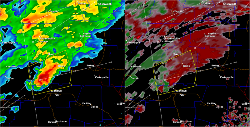
Tornado reported, Rome GA directly in it's path

0 likes


-
Category 5
- Category 5
- Posts: 10074
- Age: 36
- Joined: Sun Feb 11, 2007 10:00 pm
- Location: New Brunswick, NJ
- Contact:
Re: Wed., 9th of April 08 till Friday 11th outbreak-thread
Wall cloud sighted very close to the ground with this storm, strong rotation.

0 likes
-
Category 5
- Category 5
- Posts: 10074
- Age: 36
- Joined: Sun Feb 11, 2007 10:00 pm
- Location: New Brunswick, NJ
- Contact:
Re: Wed., 9th of April 08 till Friday 11th outbreak-thread
Category 5 wrote:Tornado reported, Rome GA directly in it's path
TOR has been discontinued, but the latest SVR mentions this.
DOPPLER RADAR HAS INDICATED WEAK ROTATION WITHIN THIS STORM. ALTHOUGH
CURRENT DATA DOES NOT INDICATE THE EXISTENCE OF A TORNADO...A TORNADO
MAY STILL DEVELOP. IF A TORNADO IS SPOTTED...ACT QUICKLY AND MOVE TO
A PLACE OF SAFETY INSIDE A STURDY STRUCTURE...SUCH AS A BASEMENT OR
SMALL INTERIOR ROOM.
0 likes
-
Category 5
- Category 5
- Posts: 10074
- Age: 36
- Joined: Sun Feb 11, 2007 10:00 pm
- Location: New Brunswick, NJ
- Contact:
Re: Wed., 9th of April 08 till Friday 11th outbreak-thread
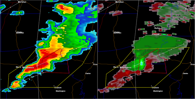
Very strong rotation now.
TORNADO WARNING
ALC023-129-112245-
/O.NEW.KMOB.TO.W.0050.080411T2215Z-080411T2245Z/
BULLETIN - EAS ACTIVATION REQUESTED
TORNADO WARNING
NATIONAL WEATHER SERVICE MOBILE AL
515 PM CDT FRI APR 11 2008
THE NATIONAL WEATHER SERVICE IN MOBILE HAS ISSUED A
* TORNADO WARNING FOR...
SOUTH CENTRAL CHOCTAW COUNTY IN SOUTHWEST ALABAMA...
NORTH CENTRAL WASHINGTON COUNTY IN SOUTHWEST ALABAMA...
* UNTIL 545 PM CDT
* AT 514 PM CDT...TRAINED WEATHER SPOTTERS REPORTED A WALL CLOUD
EAST OF AQUILA...MOVING EAST AT 25 MPH. DOPPLER RADAR CONTINUES
TO SHOW A DEEP CIRCULATION IN THIS STORM.
* THE TORNADO WILL BE NEAR...
KOENTON BY 520 PM CDT...
BLADON SPRINGS BY 525 PM CDT...
BLADON SPRINGS...SILVER CROSS...8 MILES NORTH OF BIGBEE AND 9 MILES
SOUTH OF WOMACK HILL BY 530 PM CDT...
SERVICE AND FRANKVILLE BY 535 PM CDT...
THE SAFEST PLACE TO BE DURING A TORNADO IS ON THE LOWEST FLOOR OF A
STURDY BUILDING...PREFERABLY IN AN INTERIOR HALLWAY OR A ROOM SUCH AS
A CLOSET OR BATHROOM. IF POSSIBLE...GET UNDER A WORKBENCH OR OTHER
PIECE OF STURDY FURNITURE. USE BLANKETS OR PILLOWS TO COVER YOUR BODY
AND ALWAYS STAY AWAY FROM WINDOWS. IN ADDITION TO THE TORNADO...THIS
STORM IS CAPABLE OF PRODUCING LARGE DAMAGING HAIL OR DAMAGING
STRAIGHT LINE WINDS.
IF YOU ARE IN MOBILE HOME...EVACUATE IT AND GET ON THE LOWEST FLOOR
OF A NEARBY STURDY BUILDING OR IN AN UNDERGROUND STORM SHELTER. IF NO
SUBSTANTIAL SHELTER IS AVAILABLE AND A TORNADO IS FAST APPROACHING...
SEEK SHELTER IN A CULVERT...DITCH OR LOW DEPRESSION AND COVER YOUR
HEAD WITH YOUR HANDS.
A SEVERE THUNDERSTORM WATCH REMAINS IN EFFECT UNTIL 900 PM CDT FRIDAY
EVENING FOR SOUTHWESTERN ALABAMA AND SOUTHEAST MISSISSIPPI.
LAT...LON 3186 8818 3184 8816 3182 8818 3178 8817
3176 8814 3176 8810 3160 8807 3161 8842
3175 8840
TIME...MOT...LOC 2215Z 268DEG 26KT 3172 8831
$$
TORNADO WARNING
ALC023-129-112245-
/O.NEW.KMOB.TO.W.0050.080411T2215Z-080411T2245Z/
BULLETIN - EAS ACTIVATION REQUESTED
TORNADO WARNING
NATIONAL WEATHER SERVICE MOBILE AL
515 PM CDT FRI APR 11 2008
THE NATIONAL WEATHER SERVICE IN MOBILE HAS ISSUED A
* TORNADO WARNING FOR...
SOUTH CENTRAL CHOCTAW COUNTY IN SOUTHWEST ALABAMA...
NORTH CENTRAL WASHINGTON COUNTY IN SOUTHWEST ALABAMA...
* UNTIL 545 PM CDT
* AT 514 PM CDT...TRAINED WEATHER SPOTTERS REPORTED A WALL CLOUD
EAST OF AQUILA...MOVING EAST AT 25 MPH. DOPPLER RADAR CONTINUES
TO SHOW A DEEP CIRCULATION IN THIS STORM.
* THE TORNADO WILL BE NEAR...
KOENTON BY 520 PM CDT...
BLADON SPRINGS BY 525 PM CDT...
BLADON SPRINGS...SILVER CROSS...8 MILES NORTH OF BIGBEE AND 9 MILES
SOUTH OF WOMACK HILL BY 530 PM CDT...
SERVICE AND FRANKVILLE BY 535 PM CDT...
THE SAFEST PLACE TO BE DURING A TORNADO IS ON THE LOWEST FLOOR OF A
STURDY BUILDING...PREFERABLY IN AN INTERIOR HALLWAY OR A ROOM SUCH AS
A CLOSET OR BATHROOM. IF POSSIBLE...GET UNDER A WORKBENCH OR OTHER
PIECE OF STURDY FURNITURE. USE BLANKETS OR PILLOWS TO COVER YOUR BODY
AND ALWAYS STAY AWAY FROM WINDOWS. IN ADDITION TO THE TORNADO...THIS
STORM IS CAPABLE OF PRODUCING LARGE DAMAGING HAIL OR DAMAGING
STRAIGHT LINE WINDS.
IF YOU ARE IN MOBILE HOME...EVACUATE IT AND GET ON THE LOWEST FLOOR
OF A NEARBY STURDY BUILDING OR IN AN UNDERGROUND STORM SHELTER. IF NO
SUBSTANTIAL SHELTER IS AVAILABLE AND A TORNADO IS FAST APPROACHING...
SEEK SHELTER IN A CULVERT...DITCH OR LOW DEPRESSION AND COVER YOUR
HEAD WITH YOUR HANDS.
A SEVERE THUNDERSTORM WATCH REMAINS IN EFFECT UNTIL 900 PM CDT FRIDAY
EVENING FOR SOUTHWESTERN ALABAMA AND SOUTHEAST MISSISSIPPI.
LAT...LON 3186 8818 3184 8816 3182 8818 3178 8817
3176 8814 3176 8810 3160 8807 3161 8842
3175 8840
TIME...MOT...LOC 2215Z 268DEG 26KT 3172 8831
$$
0 likes

-
Category 5
- Category 5
- Posts: 10074
- Age: 36
- Joined: Sun Feb 11, 2007 10:00 pm
- Location: New Brunswick, NJ
- Contact:
Re: Wed., 9th of April 08 till Friday 11th outbreak-thread
Very large round circulation here.
0 likes

Return to “USA & Caribbean Weather”
Who is online
Users browsing this forum: Cpv17, Google [Bot], HockeyTx82, opticsguy, wxman22 and 169 guests