
Texas Spring 2026
Moderator: S2k Moderators
Forum rules

The posts in this forum are NOT official forecast and should not be used as such. They are just the opinion of the poster and may or may not be backed by sound meteorological data. They are NOT endorsed by any professional institution or STORM2K.
-
cycloneye

- Admin

- Posts: 149204
- Age: 69
- Joined: Thu Oct 10, 2002 10:54 am
- Location: San Juan, Puerto Rico
Re: Texas Spring 2026
Welcome to Spring. The meteorological Spring season has begun as of 00:00 UTC on 3/1/26.
5 likes
Visit the Caribbean-Central America Weather Thread where you can find at first post web cams,radars
and observations from Caribbean basin members Click Here
and observations from Caribbean basin members Click Here
-
Brent
- S2K Supporter

- Posts: 38713
- Age: 37
- Joined: Sun May 16, 2004 10:30 pm
- Location: Tulsa Oklahoma
- Contact:
Re: Texas Spring 2026
It's definitely been awhile since I've seen so many days with rain chances
I'm still in believe it when I see it for the most part especially with the idea of flooding or severe weather
I'm still in believe it when I see it for the most part especially with the idea of flooding or severe weather
1 likes
#neversummer
-
wxman22

- Category 5

- Posts: 1867
- Joined: Mon Jan 30, 2006 12:39 am
- Location: Wichita Falls, TX
- Contact:
Re: Texas Spring 2026
Hello Spring! Storm season is here.
NWS Storm Prediction Center Norman OK
0359 AM CST Sun Mar 01 2026
Valid 041200Z - 091200Z
...DISCUSSION...
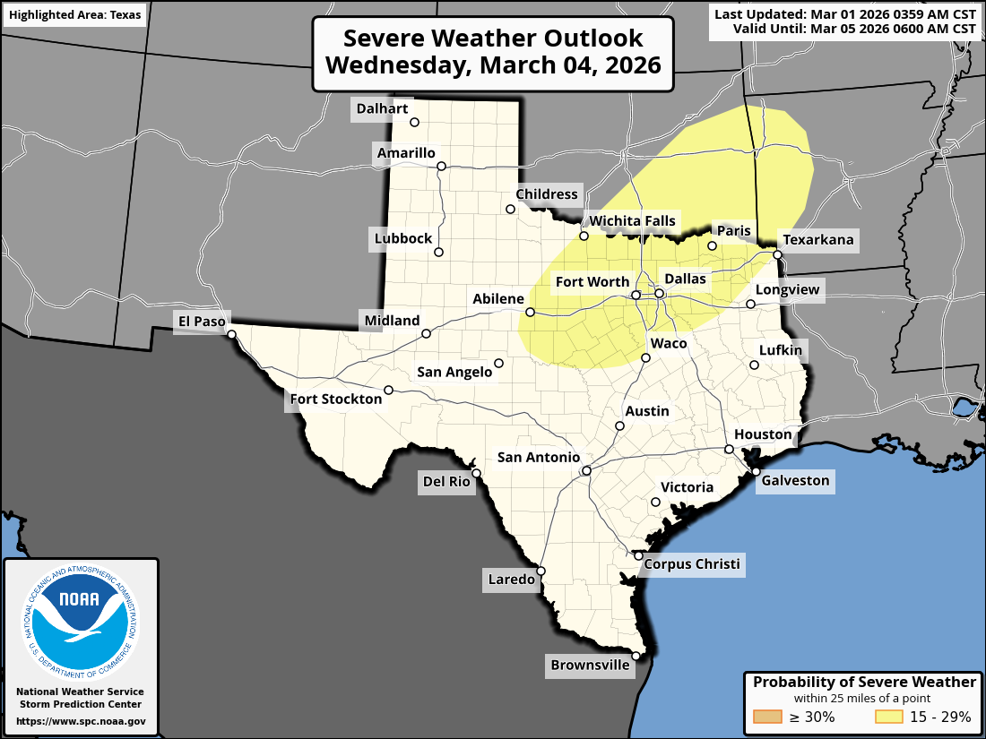
...Wednesday/Day 4 to Thursday/Day 5...
On Wednesday, model forecasts continue to move a mid-level shortwave
trough across the southern Plains. A cold front is forecast to
advance southeastward into Oklahoma as a moist and unstable airmass
resides southward from the front over much of the southern Plains.
Surface dewpoints across southeast Oklahoma and north-central to
northeast Texas should be in the lower to mid 60s F, and moderate
instability will be possible by afternoon. Thunderstorm development
appears likely across parts of this unstable airmass from the mid
afternoon into the evening. Moderate deep-layer shear should support
a severe threat, with a potential for large hail and damaging wind
gusts associated with supercells.
On Thursday, the shortwave trough is forecast to move into the mid
Mississippi Valley, as a much larger upper-level trough moves
through the Desert Southwest. A moist and unstable airmass should
remain in place over the southern Plains. However, large-scale
ascent should be weak between these two systems, which should dampen
the severe potential across most of the south-central U.S. The most
likely location for an isolated to marginal severe threat would be
in the Ark-La-Tex Thursday afternoon.
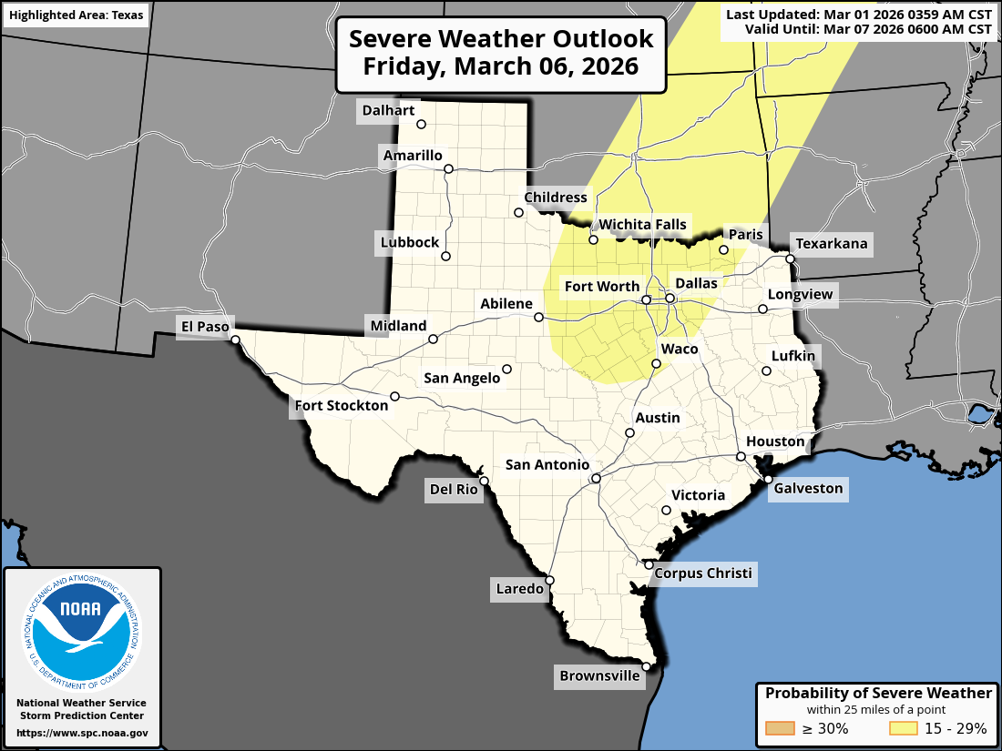
...Friday/Day 6 to Sunday/Day 8...
At mid-levels, southwest flow is forecast across much of the central
U.S. on Friday, as a large trough remains over the southwestern
states. Moisture advection is expected to continue over the Great
Plains and Upper Midwest along a corridor of strong low-level flow.
Model forecasts are in general agreement that moderate instability
will develop over much of this airmass by Friday afternoon, and that
scattered thunderstorms will form. Convective development will be
supported by the right entrance region of a mid-level jet ejecting
northeastward through the central Plains. This mid-level jet will be
associated with moderate to strong deep-layer shear, supporting
scattered severe storms potentially across a large part of the moist
sector. The current thinking is that the severe threat will be
maximized during the late afternoon and evening from central Texas
northeastward into the lower Missouri Valley. Large hail and
damaging wind gusts are expected to the primary threats, but a few
tornadoes remain possible.
On Saturday, the upper-level system in the central U.S. is forecast
to move into the Great Lakes region, as a cold front advances
quickly southeastward into the western Gulf Coast states, and lower
Mississippi Valley. An isolated severe threat could develop ahead of
the front Saturday afternoon, but confidence is low concerning the
spatial distribution of any threat. On Sunday, isolated to scattered
thunderstorms will again be possible in the Gulf Coast region.
However, deep-layer shear is forecast to be weak over much of this
area, suggesting any severe potential should remain marginal.
0 likes
-
TomballEd
- Category 5
- Posts: 1256
- Age: 62
- Joined: Wed Aug 16, 2023 4:52 pm
- Location: Spring/Klein area, not Tomball
Re: Texas Spring 2026
SPC must be going by Euro alone for Wednesday and the Euro/CMC for Friday because the GFS isn't seeing a severe weather outbreak in the next week. SPC are the experts. They must have a reason
I am hoping Euro is correct, it is wetter. Mid level winds on both models are pretty 'meh' so I wouldn't think a high end severe threat that far south with very large hail or strong tornadoes is likely.
I am hoping Euro is correct, it is wetter. Mid level winds on both models are pretty 'meh' so I wouldn't think a high end severe threat that far south with very large hail or strong tornadoes is likely.
0 likes
-
Iceresistance

- Category 5
- Posts: 9574
- Age: 22
- Joined: Sat Oct 10, 2020 9:45 am
- Location: Tecumseh, OK/Norman, OK
Re: Texas Spring 2026
Brent needs to look at this, a bit unexpected as a hail-driven risk

https://s13.gifyu.com/images/bv13E.png
https://s13.gifyu.com/images/bv13E.png
0 likes
Bill 2015 & Beta 2020
Winter 2020-2021
All observations are in Tecumseh, OK unless otherwise noted.
Winter posts are focused mainly for Oklahoma & Texas.
Take any of my forecasts with a grain of salt, refer to the NWS, SPC, and NHC for official information
Never say Never with weather! Because ANYTHING is possible!
Winter 2020-2021
All observations are in Tecumseh, OK unless otherwise noted.
Winter posts are focused mainly for Oklahoma & Texas.
Take any of my forecasts with a grain of salt, refer to the NWS, SPC, and NHC for official information
Never say Never with weather! Because ANYTHING is possible!
-
rwfromkansas
- Category 5
- Posts: 3013
- Joined: Sat Aug 27, 2005 12:47 am
- Location: North Fort Worth
Re: Texas Spring 2026
Awful winter overall, so bring on spring. Hoping for some rain, just not when they build our deck for the swim spa.
0 likes
-
ElectricStorm

- Category 5
- Posts: 5127
- Age: 25
- Joined: Tue Aug 13, 2019 11:23 pm
- Location: Norman, OK
Re: Texas Spring 2026
Well that was anticlimactic...
Down to just a general T-storm area for remainder of the night now and not seeing much on radar
Down to just a general T-storm area for remainder of the night now and not seeing much on radar
0 likes
B.S Meteorology, University of Oklahoma '25
Please refer to the NHC, NWS, or SPC for official information.
Please refer to the NHC, NWS, or SPC for official information.
-
Iceresistance
- Category 5
- Posts: 9574
- Age: 22
- Joined: Sat Oct 10, 2020 9:45 am
- Location: Tecumseh, OK/Norman, OK
Re: Texas Spring 2026
ElectricStorm wrote:Well that was anticlimactic...
Down to just a general T-storm area for remainder of the night now and not seeing much on radar
Stupid cold front surging much faster than expected and undercutting the storm development

0 likes
Bill 2015 & Beta 2020
Winter 2020-2021
All observations are in Tecumseh, OK unless otherwise noted.
Winter posts are focused mainly for Oklahoma & Texas.
Take any of my forecasts with a grain of salt, refer to the NWS, SPC, and NHC for official information
Never say Never with weather! Because ANYTHING is possible!
Winter 2020-2021
All observations are in Tecumseh, OK unless otherwise noted.
Winter posts are focused mainly for Oklahoma & Texas.
Take any of my forecasts with a grain of salt, refer to the NWS, SPC, and NHC for official information
Never say Never with weather! Because ANYTHING is possible!
Return to “USA & Caribbean Weather”
Who is online
Users browsing this forum: No registered users and 41 guests