TomballEd wrote:Chilly just now standing in the shade for a fire drill. Good news this is my conference period and I had no students.
Last chilly morning of the year?
Tomorrow morning will be a few degrees colder.
Moderator: S2k Moderators

TomballEd wrote:Chilly just now standing in the shade for a fire drill. Good news this is my conference period and I had no students.
Last chilly morning of the year?

Cpv17 wrote:Day 6 and 7 15% for west central TX/OK per the SPC.
Ntxw wrote:Not surprised the look on the ensembles for a big rain event. April and or May usually has them for the major El Ninos and this one potentially is a big one. Noted before, it's not always the flashy looking outbreaks but volume of rain and storms can produce and isolated but a big tornado event has happened before in TX during these increased rainfall/Nino coupling. Jarrell.
Cpv17 wrote:Ntxw wrote:Not surprised the look on the ensembles for a big rain event. April and or May usually has them for the major El Ninos and this one potentially is a big one. Noted before, it's not always the flashy looking outbreaks but volume of rain and storms can produce and isolated but a big tornado event has happened before in TX during these increased rainfall/Nino coupling. Jarrell.
When do you think the southern part of the state will start seeing more widespread rain?
On another note, people on X drive me crazy. So many people hyping up severe weather on there showing maps that are over two weeks out. Do they not know that has a low chance of actually verifying? Lol


wxman22 wrote:The hype on social media for the severe weather potential this weekend and next week is crazy. Some even mentioning 2011,take a chill pill people. LOL

wxman22 wrote:The hype on social media for the severe weather potential this weekend and next week is crazy. Some even mentioning 2011,take a chill pill people. LOL


HockeyTx82 wrote:I mean it's the same thing regarding winter weather
Brent wrote:HockeyTx82 wrote:I mean it's the same thing regarding winter weather
Oh why do you think I was kind of disappointed with our storm in January despite the fact it did snow 8 inches. I know some of y'all didn't see why but that was why because of the insane hype and the posts on social media all week. The expectations were just ridiculous
It gets old and it's the worst part of living here. Everything is always the worst ever

txtwister78 wrote:Brent wrote:HockeyTx82 wrote:I mean it's the same thing regarding winter weather
Oh why do you think I was kind of disappointed with our storm in January despite the fact it did snow 8 inches. I know some of y'all didn't see why but that was why because of the insane hype and the posts on social media all week. The expectations were just ridiculous
It gets old and it's the worst part of living here. Everything is always the worst ever
Probably a good test case/indicator of who to trust and avoid to get your personal weather information going forward.
Not saying this is you personally but if one chooses to follow it and get burned/upset by it when the outcome is constantly wrong, yet they keep going back for more.... Lol??? Some wish cast which attracts a following and some overhype for clicks obviously ($$$)
The irony is some will get frustrated with the NWS because they don't overhype? Lol. Nobody is perfect and with weather that's impossible to achieve but again in times of protecting life and property it shouldn't really be a debate in my opinion.
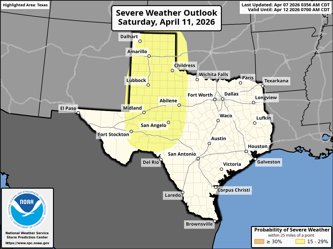
Day 4-8 Convective Outlook
NWS Storm Prediction Center Norman OK
0356 AM CDT Tue Apr 07 2026
Valid 101200Z - 151200Z
...DISCUSSION...
...Friday/Day 4 to Sunday/Day 6...
An upper-level trough will move eastward from the eastern Pacific on
Friday into the western U.S. on Saturday, as southwest mid-level
flow gradually strengthens over the south-central states. In
response, low-level moisture advection will continue over the Great
Plains. Ahead of the western U.S. trough, a subtle shortwave trough
is forecast to move into the southern High Plains Saturday
afternoon. A severe threat will be possible ahead of and near the
trough during the afternoon and evening.
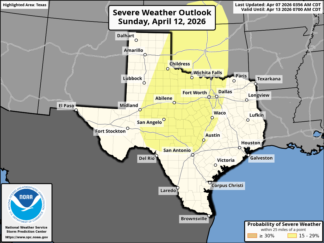
On Sunday, the western U.S. upper-level trough is forecast to move
quickly east-northeastward into the southern Rockies. Ahead of the
trough, a moist and moderately unstable airmass is forecast over
much of the southern and central Plains by afternoon. Scattered
thunderstorms appear likely to develop over much of this airmass
during the afternoon and evening. Moderate to strong deep-layer
shear appear likely to be in place, which will be favorable for
severe storms. Supercells with large hail, severe wind gusts and a
tornado threat will be possible. An isolated severe threat may also
develop in parts of the north-central U.S.
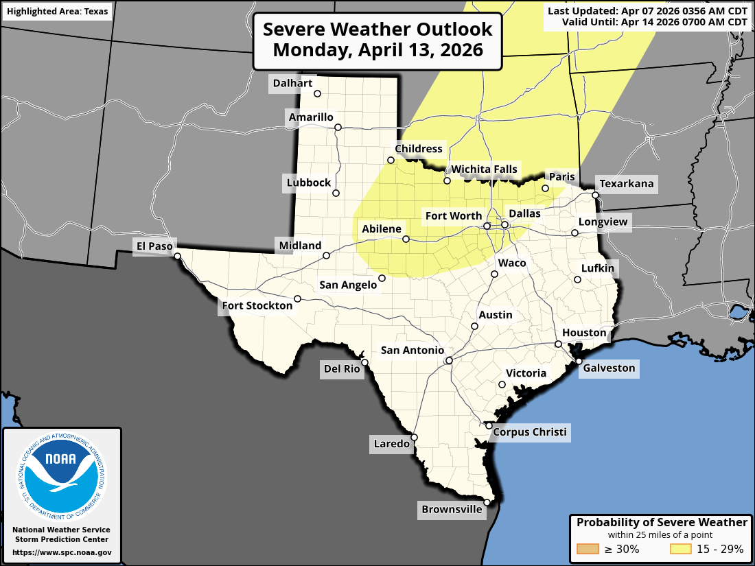
...Monday/Day 7 and Tuesday/Day 8...
A secondary upper-level trough is forecast to move into the Desert
Southwest on Monday. Ahead of this system, a moist and unstable
airmass is forecast to remain in place from the southern Plains
north-northeastward into the Upper Midwest. Although a severe threat
will be possible along much of the instability corridor, the
greatest threat is expected to develop in the southern Plains, where
model forecasts show the most favorable environment.
On Tuesday, model forecasts have some agreement concerning the
timing of the trough, which is forecast to eject northeastward
across the southern and central Plains. Ahead of the trough, there
is large variance among the models concerning the distribution of
instability. If a moderately unstable airmass is in place by Tuesday
afternoon ahead of the ejecting system, a severe threat will be
likely from the southern Plains into the mid to upper Mississippi
Valley. However, the system will probably be slower than forecast,
which adds considerable uncertainty this late in the period.
..Broyles.. 04/07/2026
Return to “USA & Caribbean Weather”
Users browsing this forum: Brent, Cpv17, HockeyTx82 and 76 guests