Texas Spring 2012
Moderator: S2k Moderators
Forum rules

The posts in this forum are NOT official forecast and should not be used as such. They are just the opinion of the poster and may or may not be backed by sound meteorological data. They are NOT endorsed by any professional institution or STORM2K.
-
~FlipFlopGirl~

- Tropical Depression

- Posts: 52
- Age: 47
- Joined: Sat Jul 24, 2010 7:43 pm
- Location: Waco,TX
-
Portastorm

- Storm2k Moderator

- Posts: 9955
- Age: 63
- Joined: Fri Jul 11, 2003 9:16 am
- Location: Round Rock, TX
- Contact:
Re: Texas Spring 2012
In its afternoon area forecast discussion (AFD), NWSFO Austin/San Antonio believes the squall line will move through the I-35 corridor in its forecast area between 2-8 am Tuesday. I don't know why, but it always seems like we (Austin) get our worst storms during the late night/early morning hours
0 likes
Any forecasts under my name are to be taken with a grain of salt. Get your best forecasts from the National Weather Service and National Hurricane Center.
-
Rgv20

- S2K Supporter

- Posts: 2466
- Age: 39
- Joined: Wed Jan 05, 2011 5:42 pm
- Location: Edinburg/McAllen Tx
Special Weather Statement
SPECIAL WEATHER STATEMENT
NATIONAL WEATHER SERVICE CORPUS CHRISTI TX
431 AM CDT SUN MAR 18 2012
TXZ229>234-239>247-190000-
LA SALLE-MCMULLEN-LIVE OAK-BEE-GOLIAD-VICTORIA-WEBB-DUVAL-
JIM WELLS-KLEBERG-NUECES-SAN PATRICIO-ARANSAS-REFUGIO-CALHOUN-
INCLUDING THE CITIES OF...COTULLA...CALLIHAM...CROSS...
LOMA ALTA...TILDEN...GEORGE WEST...THREE RIVERS...BEEVILLE...
GOLIAD...VICTORIA...LAREDO...FREER...BENAVIDES...SAN DIEGO...
ALICE...ORANGE GROVE...KINGSVILLE...CORPUS CHRISTI...PORTLAND...
INGLESIDE...ARANSAS PASS...SINTON...MATHIS...ROCKPORT...REFUGIO...
WOODSBORO...PORT LAVACA
431 AM CDT SUN MAR 18 2012
...POTENTIAL FOR STRONG TO SEVERE THUNDERSTORMS MONDAY NIGHT AND
TUESDAY MORNING OVER SOUTH TEXAS...
A POTENT UPPER LEVEL DISTURBANCE IS EXPECTED TO IMPACT SOUTH TEXAS
MONDAY NIGHT AND TUESDAY MORNING. SHOWERS AND THUNDERSTORMS ARE
EXPECTED TO DEVELOP MONDAY EVENING OVER THE EDWARDS PLATEAU AND
RIO GRANDE PLAINS. STRONG SOUTHEAST WINDS AT THE SURFACE MONDAY
NIGHT WILL HELP TO PUMP WARM AND VERY MOIST AIR INTO THE STORMS.
THIS WARM AND MOIST AIR WILL COLLIDE WITH A FRONTAL BOUNDARY...
ALLOWING STORMS TO DEVELOP FARTHER SOUTH AND EAST ALONG AND AHEAD
OF THE BOUNDARY.
WITH THE ATMOSPHERE UNSTABLE...THE STRONG WINDS NEAR THE SURFACE
WILL HELP TO PRODUCE STRONG TO POSSIBLY SEVERE THUNDERSTORMS...
ESPECIALLY OVER THE NORTHERN PORTIONS OF SOUTH TEXAS NEAR AND
NORTH OF AN ENCINAL TO SKIDMORE TO PORT LAVACA LINE. DEPENDING ON
HOW STRONG THE CAP OR INVERSION IS OVER THE REMAINDER OF SOUTH
TEXAS...STRONG TO SEVERE THUNDERSTORMS COULD OCCUR EVEN FARTHER
SOUTH. THE STORM PREDICTION CENTER INDICATES THAT THERE IS A
SLIGHT RISK FOR SEVERE THUNDERSTORMS NEAR AND NORTH OF A LINE FROM
AGUILARES TO SINTON TO PORT LAVACA. THE MAIN CONCERN WILL BE
STRONG STRAIGHT LINE WINDS ALONG THE LEADING EDGE OF THE
CONVECTIVE COMPLEX...AND POSSIBLY LARGE HAIL IN SOME OF THE
INDIVIDUAL STORMS. THE POTENTIAL FOR STRONG TO SEVERE
THUNDERSTORMS WILL DIMINISH BY LATE TUESDAY MORNING AS THE
CONVECTIVE AREA OF STORMS MOVES EAST OUT OF THE AREA.
RAINFALL AMOUNTS MONDAY NIGHT THROUGH TUESDAY ARE EXPECTED TO
AVERAGE AROUND ONE TENTH OF AN INCH OVER THE RIO GRANDE PLAINS AND
SOUTHERN BRUSH COUNTRY...1/2 INCH OR HIGHER NEAR AND NORTH OF A
COTULLA TO GEORGE WEST TO ARANSAS WILDLIFE REFUGE LINE...WITH AN
INCH OR MORE OVER NORTHERN VICTORIA COUNTY INCLUDING THE CITY OF
VICTORIA.
RESIDENTS AND MARINERS...INCLUDING EMERGENCY MANAGERS...SPOTTERS
AND LAW ENFORCEMENT...SHOULD CONTINUE TO MONITOR THE LATEST
FORECASTS FROM THE NATIONAL WEATHER SERVICE CONCERNING THIS
DEVELOPING WEATHER SITUATION. STAY TUNED TO NOAA WEATHER RADIO OR
YOUR LOCAL MEDIA FOR THE LATEST UPDATES. YOU CAN ALSO VISIT OUR
WEBSITE AT...
http://WWW.WEATHER.GOV/CORPUSCHRISTI.
0 likes
The following post is NOT an official forecast and should not be used as such. It is just the opinion of the poster and may or may not be backed by sound meteorological data. It is NOT endorsed by any professional institution including storm2k.org For Official Information please refer to the NHC and NWS products.
-
Rgv20
- S2K Supporter
- Posts: 2466
- Age: 39
- Joined: Wed Jan 05, 2011 5:42 pm
- Location: Edinburg/McAllen Tx
Flash Flood Watches issued for the Austin, San Antonio, and the Dallas area....Looks like some heavy rain to start the work week.
Flash Flood Watch
FLOOD WATCH
NATIONAL WEATHER SERVICE AUSTIN/SAN ANTONIO TX
301 PM CDT SUN MAR 18 2012
...FLASH FLOOD WATCH IN EFFECT MONDAY NIGHT THROUGH TUESDAY
MORNING ALONG AND EAST OF A LINE FROM CASTELL TO KERRVILLE TO
HONDO TO PEARSALL...
.A STRONG RAIN MAKING WEATHER SYSTEM WILL MOVE ACROSS TEXAS
TUESDAY AND TUESDAY NIGHT. THE WARM AND HUMID AIRMASS ACROSS
SOUTH CENTRAL TEXAS THE PAST FEW DAYS WILL CONTINUE THROUGH
MONDAY NIGHT. AS THE STORM SYSTEM MOVES ACROSS SOUTH CENTRAL
TEXAS TUESDAY...A PACIFIC COLD FRONT WILL ACCOMPANY THIS WEATHER
SYSTEM...AND MOVE ACROSS SOUTH CENTRAL TEXAS TUESDAY MORNING.
UNSTABLE CONDITIONS WILL PERSIST MONDAY NIGHT AND TUESDAY
MORNING. THIS ENVIRONMENT WILL CREATE SHOWERS AND THUNDERSTORMS
WITH LOCALLY HEAVY RAIN MONDAY NIGHT AND TUESDAY MORNING...ALONG
WITH STRONG TO SEVERE THUNDERSTORMS. THESE RAINS WILL COME AFTER
SCATTERED SHOWERS AND ISOLATED THUNDERSTORMS MAINLY OUT WEST LATE
THIS AFTERNOON AND EVENING AND DURING THE DAY ON MONDAY. IN
ADDITION...THE WINTER PERIOD FROM DECEMBER TO FEBRUARY WAS THE 4TH
WETTEST DECEMBER TO FEBRUARY AT SAN ANTONIO...THE 2ND WETTEST AT
AUSTIN BERGSTROM...AND THE 14TH WETTEST DECEMBER TO FEBRUARY AT
AUSTIN MABRY. MORE CLOUD COVER THAN USUAL HAS PERSISTED SINCE
DECEMBER...REDUCING THE USUAL AMOUNT OF EVAPORATION. THESE
CONDITIONS HAVE LEFT SOILS MORE SATURATED THAN USUAL. AS A
RESULT...WITH THE LIKELYHOOD OF MORE RAIN MONDAY NIGHT AND TUESDAY
MORNING... RUNOFF WILL BE MORE LIKELY AND COULD LEAD TO FLASH
FLOODING...ACROSS SOUTH CENTRAL TEXAS ALONG AND EAST OF A LINE
FROM CASTELL TO KERRVILLE TO HONDO TO PEARSALL. THIS INCLUDES THE
AUSTIN AND SAN ANTONIO METROPOLITAN AREAS.
TXC013-019-021-029-031-053-055-091-123-149-163-171-177-187-209-
255-259-265-285-287-299-325-453-491-493-190700-
/O.CON.KEWX.FF.A.0003.120319T2300Z-120320T1700Z/
/00000.0.ER.000000T0000Z.000000T0000Z.000000T0000Z.OO/
ATASCOSA-BANDERA-BASTROP-BEXAR-BLANCO-BURNET-CALDWELL-COMAL-
DEWITT-FAYETTE-FRIO-GILLESPIE-GONZALES-GUADALUPE-HAYS-KARNES-
KENDALL-KERR-LAVACA-LEE-LLANO-MEDINA-TRAVIS-WILLIAMSON-WILSON-
INCLUDING THE CITIES OF...PLEASANTON...BANDERA...BASTROP...
SAN ANTONIO...BLANCO...BURNET...LOCKHART...NEW BRAUNFELS...
CUERO...LA GRANGE...PEARSALL...FREDERICKSBURG...GONZALES...
SEGUIN...SAN MARCOS...KARNES CITY...BOERNE...KERRVILLE...
HALLETTSVILLE...GIDDINGS...LLANO...HONDO...AUSTIN...GEORGETOWN...
FLORESVILLE
301 PM CDT SUN MAR 18 2012
...FLASH FLOOD WATCH REMAINS IN EFFECT FROM MONDAY EVENING
THROUGH TUESDAY MORNING...
THE FLASH FLOOD WATCH CONTINUES FOR
* THE FOLLOWING COUNTIES IN SOUTH CENTRAL TEXAS...ATASCOSA...
BANDERA...BASTROP...BEXAR...BLANCO...BURNET...CALDWELL...
COMAL...DEWITT...FAYETTE...FRIO...GILLESPIE...GONZALES...
GUADALUPE...HAYS...KARNES...KENDALL...KERR...LAVACA...LEE...
LLANO...MEDINA...TRAVIS...WILLIAMSON AND WILSON.
* FROM MONDAY EVENING THROUGH TUESDAY MORNING
* A STRONG RAIN MAKING WEATHER SYSTEM WILL MOVE ACROSS TEXAS
TUESDAY AND TUESDAY NIGHT. THE WARM AND HUMID AIRMASS ACROSS
SOUTH CENTRAL TEXAS THE PAST FEW DAYS WILL CONTINUE THROUGH
MONDAY NIGHT. AS THE STORM SYSTEM MOVES ACROSS SOUTH CENTRAL
TEXAS TUESDAY...A PACIFIC COLD FRONT WILL ACCOMPANY THIS WEATHER
SYSTEM...AND MOVE ACROSS SOUTH CENTRAL TEXAS TUESDAY MORNING.
UNSTABLE CONDITIONS WILL PERSIST MONDAY NIGHT AND TUESDAY
MORNING. THIS ENVIRONMENT WILL CREATE SHOWERS AND THUNDERSTORMS
WITH LOCALLY HEAVY RAIN MONDAY NIGHT AND TUESDAY MORNING...ALONG
WITH STRONG TO SEVERE THUNDERSTORMS. THESE RAINS WILL COME AFTER
SCATTERED SHOWERS AND ISOLATED THUNDERSTORMS MAINLY OUT WEST
LATE THIS AFTERNOON INTO THE EVENING AND DURING THE DAY ON
MONDAY. IN ADDITION...THE WINTER PERIOD FROM DECEMBER TO
FEBRUARY WAS THE 4TH WETTEST DECEMBER TO FEBRUARY AT SAN
ANTONIO...THE 2ND WETTEST AT AUSTIN BERGSTROM...AND THE 14TH
WETTEST DECEMBER TO FEBRUARY AT AUSTIN MABRY. MORE CLOUD COVER
THAN USUAL HAS PERSISTED SINCE DECEMBER... REDUCING THE USUAL
AMOUNT OF EVAPORATION. THESE CONDITIONS HAVE LEFT SOILS MORE
SATURATED THAN USUAL. AS A RESULT...WITH THE LIKELYHOOD OF MORE
RAIN MONDAY NIGHT AND TUESDAY MORNING...RUNOFF WILL BE MORE
LIKELY AND COULD LEAD TO FLASH FLOODING...ACROSS SOUTH CENTRAL
TEXAS ALONG AND EAST OF A LINE FROM CASTELL TO KERRVILLE TO
HONDO TO PEARSALL. THIS INCLUDES THE AUSTIN AND SAN ANTONIO
METROPOLITAN AREAS. RAINFALL AMOUNTS OF 1 TO 3 INCHES CAN BE
EXPECTED...WITH ISOLATED AMOUNTS OF 4 TO 6 INCHES OF RAIN
POSSIBLE.
* THE HEAVY RAINS EXPECTED MAY PRODUCE RISES ON AREA RIVERS AND
STREAMS WITH THE GREATEST THREAT OVER THE LOWER GUADALUPE...
SAN ANTONIO AND LAVACA NAVIDAD RIVER BASINS.
PRECAUTIONARY/PREPAREDNESS ACTIONS...
A FLASH FLOOD WATCH MEANS FLASH FLOODING IS POSSIBLE IN OR NEAR
THE WATCH AREA. IF YOU ARE IN THE WATCH AREA...PLAN NOW FOR WHAT
YOU WILL DO IF FLASH FLOODING DEVELOPS. STAY INFORMED AND BE
READY TO ACT IF YOU SEE FLOODING OR IF A FLASH FLOOD WARNING IS
ISSUED.
&&
$$
Flash Flood Watch
FLOOD WATCH
NATIONAL WEATHER SERVICE FORT WORTH TX
221 PM CDT SUN MAR 18 2012
TXZ092>095-103>107-118>123-133>135-144>148-156>162-174-175-191000-
/O.NEW.KFWD.FF.A.0002.120319T1200Z-120321T0500Z/
/00000.0.ER.000000T0000Z.000000T0000Z.000000T0000Z.OO/
COOKE-GRAYSON-FANNIN-LAMAR-DENTON-COLLIN-HUNT-DELTA-HOPKINS-
TARRANT-DALLAS-ROCKWALL-KAUFMAN-VAN ZANDT-RAINS-JOHNSON-ELLIS-
HENDERSON-BOSQUE-HILL-NAVARRO-FREESTONE-ANDERSON-LAMPASAS-CORYELL-
BELL-MCLENNAN-FALLS-LIMESTONE-LEON-MILAM-ROBERTSON-
221 PM CDT SUN MAR 18 2012
...FLASH FLOOD WATCH IN EFFECT FROM MONDAY MORNING THROUGH
TUESDAY EVENING...
THE NATIONAL WEATHER SERVICE IN FORT WORTH HAS ISSUED A
* FLASH FLOOD WATCH FOR THE FOLLOWING COUNTIES IN NORTH CENTRAL
TEXAS...BELL...BOSQUE...COLLIN...COOKE...CORYELL...DALLAS...
DENTON...ELLIS...FALLS...FANNIN...FREESTONE...GRAYSON...HILL...
HUNT...JOHNSON...KAUFMAN...LAMPASAS...LIMESTONE...MCLENNAN...
NAVARRO...ROCKWALL AND TARRANT. IN NORTHEAST TEXAS...
ANDERSON...DELTA...HENDERSON...HOPKINS...LAMAR...LEON...RAINS
AND VAN ZANDT. IN SOUTH CENTRAL TEXAS...MILAM AND ROBERTSON.
* FROM MONDAY MORNING THROUGH TUESDAY EVENING.
* SEVERAL ROUNDS OF SHOWERS AND THUNDERSTORMS CONTAINING LOCALLY
HEAVY RAINFALL WILL OCCUR THROUGH TUESDAY EVENING. TRAINING OF
HEAVIER RAINFALL IS LIKELY WITH RAINFALL AMOUNTS OF 3 TO 6
INCHES...WITH LOCALLY HIGHER AMOUNTS EXPECTED ACROSS THE WATCH
AREA.
* FLASH FLOODING IS POSSIBLE ACROSS AREAS SUSCEPTIBLE TO FLASH
FLOODING SUCH AS METRO AREAS...UNDERPASSES...LOW WATER
CROSSINGS...FLASHY SMALL CREEKS...AND OTHER LOW LYING AREAS THAT
NORMALLY FLOOD EASILY. RIVER FLOODING MAY OCCUR EVENTUALLY WITH
TIME AS WELL ALONG THE BRAZOS...TRINITY...SUPLHUR AND SABINE
RIVER BASINS.
PRECAUTIONARY/PREPAREDNESS ACTIONS...
A FLASH FLOOD WATCH MEANS THAT CONDITIONS ARE FAVORABLE FOR HEAVY
RAIN WHICH MAY LEAD TO FLASH FLOODING. YOU SHOULD MONITOR THE
LATEST FORECASTS FROM THE NATIONAL WEATHER SERVICE AND BE
PREPARED TO TAKE ACTION SHOULD FLASH FLOOD WARNINGS BE ISSUED FOR
YOUR AREA.
&&
$$
05/
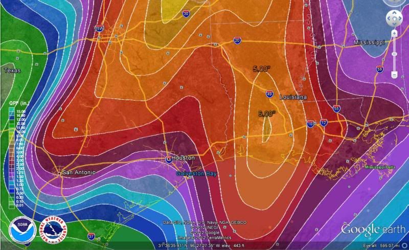
Here is a close look at the HPC 5 day Rainfall Totals forecast.
Flash Flood Watch
FLOOD WATCH
NATIONAL WEATHER SERVICE AUSTIN/SAN ANTONIO TX
301 PM CDT SUN MAR 18 2012
...FLASH FLOOD WATCH IN EFFECT MONDAY NIGHT THROUGH TUESDAY
MORNING ALONG AND EAST OF A LINE FROM CASTELL TO KERRVILLE TO
HONDO TO PEARSALL...
.A STRONG RAIN MAKING WEATHER SYSTEM WILL MOVE ACROSS TEXAS
TUESDAY AND TUESDAY NIGHT. THE WARM AND HUMID AIRMASS ACROSS
SOUTH CENTRAL TEXAS THE PAST FEW DAYS WILL CONTINUE THROUGH
MONDAY NIGHT. AS THE STORM SYSTEM MOVES ACROSS SOUTH CENTRAL
TEXAS TUESDAY...A PACIFIC COLD FRONT WILL ACCOMPANY THIS WEATHER
SYSTEM...AND MOVE ACROSS SOUTH CENTRAL TEXAS TUESDAY MORNING.
UNSTABLE CONDITIONS WILL PERSIST MONDAY NIGHT AND TUESDAY
MORNING. THIS ENVIRONMENT WILL CREATE SHOWERS AND THUNDERSTORMS
WITH LOCALLY HEAVY RAIN MONDAY NIGHT AND TUESDAY MORNING...ALONG
WITH STRONG TO SEVERE THUNDERSTORMS. THESE RAINS WILL COME AFTER
SCATTERED SHOWERS AND ISOLATED THUNDERSTORMS MAINLY OUT WEST LATE
THIS AFTERNOON AND EVENING AND DURING THE DAY ON MONDAY. IN
ADDITION...THE WINTER PERIOD FROM DECEMBER TO FEBRUARY WAS THE 4TH
WETTEST DECEMBER TO FEBRUARY AT SAN ANTONIO...THE 2ND WETTEST AT
AUSTIN BERGSTROM...AND THE 14TH WETTEST DECEMBER TO FEBRUARY AT
AUSTIN MABRY. MORE CLOUD COVER THAN USUAL HAS PERSISTED SINCE
DECEMBER...REDUCING THE USUAL AMOUNT OF EVAPORATION. THESE
CONDITIONS HAVE LEFT SOILS MORE SATURATED THAN USUAL. AS A
RESULT...WITH THE LIKELYHOOD OF MORE RAIN MONDAY NIGHT AND TUESDAY
MORNING... RUNOFF WILL BE MORE LIKELY AND COULD LEAD TO FLASH
FLOODING...ACROSS SOUTH CENTRAL TEXAS ALONG AND EAST OF A LINE
FROM CASTELL TO KERRVILLE TO HONDO TO PEARSALL. THIS INCLUDES THE
AUSTIN AND SAN ANTONIO METROPOLITAN AREAS.
TXC013-019-021-029-031-053-055-091-123-149-163-171-177-187-209-
255-259-265-285-287-299-325-453-491-493-190700-
/O.CON.KEWX.FF.A.0003.120319T2300Z-120320T1700Z/
/00000.0.ER.000000T0000Z.000000T0000Z.000000T0000Z.OO/
ATASCOSA-BANDERA-BASTROP-BEXAR-BLANCO-BURNET-CALDWELL-COMAL-
DEWITT-FAYETTE-FRIO-GILLESPIE-GONZALES-GUADALUPE-HAYS-KARNES-
KENDALL-KERR-LAVACA-LEE-LLANO-MEDINA-TRAVIS-WILLIAMSON-WILSON-
INCLUDING THE CITIES OF...PLEASANTON...BANDERA...BASTROP...
SAN ANTONIO...BLANCO...BURNET...LOCKHART...NEW BRAUNFELS...
CUERO...LA GRANGE...PEARSALL...FREDERICKSBURG...GONZALES...
SEGUIN...SAN MARCOS...KARNES CITY...BOERNE...KERRVILLE...
HALLETTSVILLE...GIDDINGS...LLANO...HONDO...AUSTIN...GEORGETOWN...
FLORESVILLE
301 PM CDT SUN MAR 18 2012
...FLASH FLOOD WATCH REMAINS IN EFFECT FROM MONDAY EVENING
THROUGH TUESDAY MORNING...
THE FLASH FLOOD WATCH CONTINUES FOR
* THE FOLLOWING COUNTIES IN SOUTH CENTRAL TEXAS...ATASCOSA...
BANDERA...BASTROP...BEXAR...BLANCO...BURNET...CALDWELL...
COMAL...DEWITT...FAYETTE...FRIO...GILLESPIE...GONZALES...
GUADALUPE...HAYS...KARNES...KENDALL...KERR...LAVACA...LEE...
LLANO...MEDINA...TRAVIS...WILLIAMSON AND WILSON.
* FROM MONDAY EVENING THROUGH TUESDAY MORNING
* A STRONG RAIN MAKING WEATHER SYSTEM WILL MOVE ACROSS TEXAS
TUESDAY AND TUESDAY NIGHT. THE WARM AND HUMID AIRMASS ACROSS
SOUTH CENTRAL TEXAS THE PAST FEW DAYS WILL CONTINUE THROUGH
MONDAY NIGHT. AS THE STORM SYSTEM MOVES ACROSS SOUTH CENTRAL
TEXAS TUESDAY...A PACIFIC COLD FRONT WILL ACCOMPANY THIS WEATHER
SYSTEM...AND MOVE ACROSS SOUTH CENTRAL TEXAS TUESDAY MORNING.
UNSTABLE CONDITIONS WILL PERSIST MONDAY NIGHT AND TUESDAY
MORNING. THIS ENVIRONMENT WILL CREATE SHOWERS AND THUNDERSTORMS
WITH LOCALLY HEAVY RAIN MONDAY NIGHT AND TUESDAY MORNING...ALONG
WITH STRONG TO SEVERE THUNDERSTORMS. THESE RAINS WILL COME AFTER
SCATTERED SHOWERS AND ISOLATED THUNDERSTORMS MAINLY OUT WEST
LATE THIS AFTERNOON INTO THE EVENING AND DURING THE DAY ON
MONDAY. IN ADDITION...THE WINTER PERIOD FROM DECEMBER TO
FEBRUARY WAS THE 4TH WETTEST DECEMBER TO FEBRUARY AT SAN
ANTONIO...THE 2ND WETTEST AT AUSTIN BERGSTROM...AND THE 14TH
WETTEST DECEMBER TO FEBRUARY AT AUSTIN MABRY. MORE CLOUD COVER
THAN USUAL HAS PERSISTED SINCE DECEMBER... REDUCING THE USUAL
AMOUNT OF EVAPORATION. THESE CONDITIONS HAVE LEFT SOILS MORE
SATURATED THAN USUAL. AS A RESULT...WITH THE LIKELYHOOD OF MORE
RAIN MONDAY NIGHT AND TUESDAY MORNING...RUNOFF WILL BE MORE
LIKELY AND COULD LEAD TO FLASH FLOODING...ACROSS SOUTH CENTRAL
TEXAS ALONG AND EAST OF A LINE FROM CASTELL TO KERRVILLE TO
HONDO TO PEARSALL. THIS INCLUDES THE AUSTIN AND SAN ANTONIO
METROPOLITAN AREAS. RAINFALL AMOUNTS OF 1 TO 3 INCHES CAN BE
EXPECTED...WITH ISOLATED AMOUNTS OF 4 TO 6 INCHES OF RAIN
POSSIBLE.
* THE HEAVY RAINS EXPECTED MAY PRODUCE RISES ON AREA RIVERS AND
STREAMS WITH THE GREATEST THREAT OVER THE LOWER GUADALUPE...
SAN ANTONIO AND LAVACA NAVIDAD RIVER BASINS.
PRECAUTIONARY/PREPAREDNESS ACTIONS...
A FLASH FLOOD WATCH MEANS FLASH FLOODING IS POSSIBLE IN OR NEAR
THE WATCH AREA. IF YOU ARE IN THE WATCH AREA...PLAN NOW FOR WHAT
YOU WILL DO IF FLASH FLOODING DEVELOPS. STAY INFORMED AND BE
READY TO ACT IF YOU SEE FLOODING OR IF A FLASH FLOOD WARNING IS
ISSUED.
&&
$$
Flash Flood Watch
FLOOD WATCH
NATIONAL WEATHER SERVICE FORT WORTH TX
221 PM CDT SUN MAR 18 2012
TXZ092>095-103>107-118>123-133>135-144>148-156>162-174-175-191000-
/O.NEW.KFWD.FF.A.0002.120319T1200Z-120321T0500Z/
/00000.0.ER.000000T0000Z.000000T0000Z.000000T0000Z.OO/
COOKE-GRAYSON-FANNIN-LAMAR-DENTON-COLLIN-HUNT-DELTA-HOPKINS-
TARRANT-DALLAS-ROCKWALL-KAUFMAN-VAN ZANDT-RAINS-JOHNSON-ELLIS-
HENDERSON-BOSQUE-HILL-NAVARRO-FREESTONE-ANDERSON-LAMPASAS-CORYELL-
BELL-MCLENNAN-FALLS-LIMESTONE-LEON-MILAM-ROBERTSON-
221 PM CDT SUN MAR 18 2012
...FLASH FLOOD WATCH IN EFFECT FROM MONDAY MORNING THROUGH
TUESDAY EVENING...
THE NATIONAL WEATHER SERVICE IN FORT WORTH HAS ISSUED A
* FLASH FLOOD WATCH FOR THE FOLLOWING COUNTIES IN NORTH CENTRAL
TEXAS...BELL...BOSQUE...COLLIN...COOKE...CORYELL...DALLAS...
DENTON...ELLIS...FALLS...FANNIN...FREESTONE...GRAYSON...HILL...
HUNT...JOHNSON...KAUFMAN...LAMPASAS...LIMESTONE...MCLENNAN...
NAVARRO...ROCKWALL AND TARRANT. IN NORTHEAST TEXAS...
ANDERSON...DELTA...HENDERSON...HOPKINS...LAMAR...LEON...RAINS
AND VAN ZANDT. IN SOUTH CENTRAL TEXAS...MILAM AND ROBERTSON.
* FROM MONDAY MORNING THROUGH TUESDAY EVENING.
* SEVERAL ROUNDS OF SHOWERS AND THUNDERSTORMS CONTAINING LOCALLY
HEAVY RAINFALL WILL OCCUR THROUGH TUESDAY EVENING. TRAINING OF
HEAVIER RAINFALL IS LIKELY WITH RAINFALL AMOUNTS OF 3 TO 6
INCHES...WITH LOCALLY HIGHER AMOUNTS EXPECTED ACROSS THE WATCH
AREA.
* FLASH FLOODING IS POSSIBLE ACROSS AREAS SUSCEPTIBLE TO FLASH
FLOODING SUCH AS METRO AREAS...UNDERPASSES...LOW WATER
CROSSINGS...FLASHY SMALL CREEKS...AND OTHER LOW LYING AREAS THAT
NORMALLY FLOOD EASILY. RIVER FLOODING MAY OCCUR EVENTUALLY WITH
TIME AS WELL ALONG THE BRAZOS...TRINITY...SUPLHUR AND SABINE
RIVER BASINS.
PRECAUTIONARY/PREPAREDNESS ACTIONS...
A FLASH FLOOD WATCH MEANS THAT CONDITIONS ARE FAVORABLE FOR HEAVY
RAIN WHICH MAY LEAD TO FLASH FLOODING. YOU SHOULD MONITOR THE
LATEST FORECASTS FROM THE NATIONAL WEATHER SERVICE AND BE
PREPARED TO TAKE ACTION SHOULD FLASH FLOOD WARNINGS BE ISSUED FOR
YOUR AREA.
&&
$$
05/
Here is a close look at the HPC 5 day Rainfall Totals forecast.
0 likes
The following post is NOT an official forecast and should not be used as such. It is just the opinion of the poster and may or may not be backed by sound meteorological data. It is NOT endorsed by any professional institution including storm2k.org For Official Information please refer to the NHC and NWS products.
-
Portastorm
- Storm2k Moderator
- Posts: 9955
- Age: 63
- Joined: Fri Jul 11, 2003 9:16 am
- Location: Round Rock, TX
- Contact:
Re: Texas Spring 2012
The GFS trends wetter and wetter each run its seems, at least for my area (AUS). Now looking at about 4.4 inches as a result of the coming event. Yesterday it was showing about 3.6 inches. NWS suggests the squall line will be slow-moving and will move through the I-35 corridor in south central Texas between 2-8 am Tuesday.
0 likes
Any forecasts under my name are to be taken with a grain of salt. Get your best forecasts from the National Weather Service and National Hurricane Center.

Re: Texas Spring 2012
Yeah, it does look a lot wetter.
Rgv20, where did you get that map with the rainfall predictions from? It looks similar to a one I see on HPC QPF but it goes by 2" increments at higher rain amounts.
Rgv20, where did you get that map with the rainfall predictions from? It looks similar to a one I see on HPC QPF but it goes by 2" increments at higher rain amounts.
0 likes
-
rickcarpenter
- Tropical Wave

- Posts: 4
- Joined: Mon Jan 02, 2012 9:02 pm
- Location: Huntsville, East Texas
Re: Texas Spring 2012
While some drought conditions might be improving now in Texas, the damage from 2011 will last a long time. One ag professor I know says that trees will continue to die for 5 years. With the countless dead, dying, or damaged trees and other fuels, storm or fire event impacts will be more severe. I'm enjoying the rain while we have it, but I'm buckling up for whatever comes.
0 likes
-
somethingfunny

- ChatStaff

- Posts: 3926
- Age: 37
- Joined: Thu May 31, 2007 10:30 pm
- Location: McKinney, Texas

There's a 45% probability for severe wind in roughly the same area as the MDT. 10% tornado probs, and a 15% probability of hail >2", with a hatchmarking for much of Central Texas.
Now for the AFD quotes....
Fort Worth WFO update from around midnight CDT wrote:MAIN FORECAST CHALLENGE IS TIMING OF CONVECTIVE EPISODES...WITH AT
LEAST 2 ROUNDS OF STORMS LOOKING LIKELY. CONFIDENCE IS INCREASING
ON A ROUND OF THUNDERSTORMS ARRIVING INTO THE METROPLEX AFTER
15Z/10AM. THIS ACTIVITY APPEARS TO BE DEVELOPING NOW DEVELOPING
IN WEST TEXAS. RUC FORECASTS SURFACE TROUGH/DRY LINE TO REACH
WESTERN TRACON BY 15Z WITH LINE OF STORMS HOLDING TOGETHER LONG
ENOUGH TO REACH METROPLEX TAF SITES SHORTLY THEREAFTER. WILL SHOW
PREVAILING TSRA FROM 15-19Z. THIS FIRST LINE OF CONVECTION SHOULD
NOT BLOW THROUGH AND SCOUR THE AIRMASS...AND WITH THE DRY LINE
HANGING BACK TO THE WEST ADDITIONAL SCATTERED STORMS ARE POSSIBLE
IN THE MID AFTERNOON THROUGH EARLY EVENING HOURS. WILL SHOW VCTS
IN THIS PERIOD SINCE CONFIDENCE IS NOT HIGH ENOUGH TO PICK A
SPECIFIC TIME PERIOD TO PREVAIL TSRA. PRIMARY UPPER LEVEL FORCING
DOES NOT ARRIVE UNTIL AROUND MIDNIGHT WHEN A SOLID LINE OF STORMS
WILL LIKELY DEVELOP ALONG THE I-35 CORRIDOR AND SLOWLY ADVANCE
EASTWARD. THE LOCATION OF THIS LINE WILL PUT TAF SITES PRIMARILY
ON THE BACKSIDE OF THE CONVECTIVE COMPLEX AND THEREFORE EXPECT
STEADY MODERATE TO HEAVY RAIN AND OCCASIONAL THUNDER PREVAILING
LATE MONDAY EVENING THROUGH TUESDAY MORNING.
National Storm Prediction Center, Norman OK wrote:...SYNOPSIS...
AN EXPANSIVE FULL LATITUDE UPPER TROUGH WILL OVERSPREAD THE SRN AND
CNTRL PLAINS ON MONDAY WITH MERIDIONAL STYLE FLOW REGIME. SLY LOW
LEVEL FLOW WILL PERSIST THROUGHOUT THE PERIOD AHEAD OF A COLD
FRONT...RESULTING IN AMPLE MOISTURE AND INSTABILITY FOR WIDESPREAD
THUNDERSTORMS FROM TX INTO MN AND WI. THIS FRONT IS FORECAST TO
EXTEND FROM WRN/CNTRL OK INTO WRN N TX EARLY MON...BUT SHOULD STALL
ACROSS CNTRL TX.
MULTIPLE EPISODES OF SEVERE THUNDERSTORMS ARE EXPECTED ACROSS THE
SRN PLAINS...AND THERE IS A WIDE VARIETY OF MODEL SOLUTIONS.
HOWEVER...IT APPEARS CONSENSUS IS FOR WIDESPREAD SEVERE STORMS
CENTERED OVER THE MDT RISK AREA...FROM CNTRL/NERN TX INTO SERN OK.
...TX INTO OK AND THE ARKLATEX REGION...
A COMPLICATED CONVECTIVE DAY WILL UNFOLD ON MONDAY. UNCERTAINTIES
BEGIN EARLY IN THE MORNING IN RELATION TO WHERE A SQUALL LINE...NOW
OVER WRN TX...WILL BE LOCATED...AND HOW MUCH COLD POOL AND
STABILIZATION WILL OCCUR WITH THIS SYSTEM. MODELS GENERALLY SUGGEST
THIS LINE WILL BE OVER W CNTRL OK INTO WRN N TX AT 12Z...WITH SRN
END NEAR I-20. THIS ACTIVITY WILL BE IN A STRONGLY SHEARED
ENVIRONMENT...AND STRONG TO SEVERE WINDS WILL BE POSSIBLE IN
ADDITION TO SOME HAIL. THIS ACTIVITY MAY REJUVENATE OVER ERN OK/NERN
TX WITH A STRONG 50 KT LOW LEVEL JET FEEDING INTO THAT AREA. LATER
IN THE AFTERNOON IN THIS SAME GENERAL VICINITY...ADDITIONAL
DEVELOPMENT FUELED BY WARM ADVECTION MAY OCCUR WITH CONVECTION
ALLOWING MODELS DEPICTING ISOLATED SUPERCELLS. SHEAR WOULD FAVOR
DAMAGING WINDS AND A FEW TORNADOES.
THE GREATEST SEVERE THREAT SHOULD BE DURING THE AFTERNOON AND INTO
THE EVENING OVER MUCH OF CNTRL TX. AS OF THIS WRITING...THIS AREA
SHOULD BE S OF THE MORNING ACTIVITY...AND ON THE INTERFACE OF STRONG
HEATING PROGGED OVER WRN/W CNTRL TX. FORECAST SOUNDINGS SHOW STEEP
LAPSE RATES ALOFT...STRONG INSTABILITY...AND AMPLE DEEP LAYER SHEAR
FOR SIGNIFICANT SEVERE WEATHER INCLUDING VERY LARGE HAIL...DAMAGING
WINDS AND TORNADOES. ISOLATED STRONG TORNADOES MAY OCCUR...BUT WILL
DEFER POSSIBLE SIGNIFICANT TORNADO PROBABILITIES TO LATER OUTLOOKS
GIVEN UNCERTAINTIES WITH LOW LEVEL FLOW AND BOUNDARY LOCATIONS.
CONVECTIVE COVERAGE WILL ONLY INCREASE OVERNIGHT WITH COUPLED JET
STRUCTURE ALOFT LIKELY RESULTING IN A LARGE MCS WITH SEVERE WEATHER
AND FLOODING RAIN.
0 likes
I am not a meteorologist, and any posts made by me are not official forecasts or to be interpreted as being intelligent. These posts are just my opinions and are probably silly opinions.
-
Portastorm
- Storm2k Moderator
- Posts: 9955
- Age: 63
- Joined: Fri Jul 11, 2003 9:16 am
- Location: Round Rock, TX
- Contact:
Re: Texas Spring 2012
I can't remember the last time Austin was in a "moderate risk" area per SPC, but we are today. Severe storms, hail, damaging winds, 2-5 inches of rain, and ... oh yeah ... possibility of tornadoes! 
Admittedly, I am concerned.
AREA FORECAST DISCUSSION
NATIONAL WEATHER SERVICE AUSTIN/SAN ANTONIO TX
409 AM CDT MON MAR 19 2012
.DISCUSSION...
A DEEP UPPER LEVEL TROF CAN BE SEEN ON WV SAT IMAGERY MOVING
THROUGH THE WESTERN US THIS MORNING. 06Z SFC ANALYSIS A COLD FRONT
EXTENDING FROM A LOW OVER EASTERN MT DOWN THROUGH THE TX PANHANDLE
AND ACROSS W TX. THERE IS A SQUALL LINE AHEAD OF THE FRONT FROM
WESTERN OK TO NEAR MIDLAND. THIS SYSTEM WILL PROPAGATE EASTWARD
TODAY AND TUE AND BRING SIGNIFICANT WEATHER TO SOUTH CENTRAL
TEXAS. AS THE UPPER TROF MOVES TOWARD THE EAST IT WILL FORCE
CONVECTION ACROSS OUR CWA. MODELS ARE IN GOOD AGREEMENT ON SHORT
TERM MOVEMENT OF THE SYSTEM. ATMOSPHERE WILL BECOME MORE UNSTABLE
THROUGH THE DAY TODAY AND LOW LEVEL MOISTURE IS ALREADY IN PLACE.
MODEL CAPE FORECASTS ARE AS HIGH AS 2500 J/KG. IN ADDITION AS THE
TROF APPROACHES VERTICAL WIND SHEAR WILL INCREASE. SEVERE
THUNDERSTORMS ARE LIKELY THIS AFTERNOON AND EVENING AND SPC HAS
INCLUDED MOST OF OUR CWA IN A SLIGHT RISK AREA AND THE
NORTHEASTERN QUARTER OF THE AREA IN A MODERATE RISK. THE FULL
SPECTRUM OF SEVERE...TORNADOES...DAMAGING WIND...AND LARGE
HAIL...IS POSSIBLE. TIMING IS STILL UNCERTAIN...BUT 1PM TIL
MIDNIGHT LOOKS LIKELY. IN ADDITION TO THE SEVERE THREAT FLASH
FLOODING IS POSSIBLE AND WILL CONTINUE THE FLASH FLOOD WATCH FOR
TONIGHT THROUGH TUE MORNING. PW WILL GENERALLY BE BETWEEN ONE AND
ONE AND ONE HALF INCHES ACROSS THE EASTERN HALF OF THE AREA
TONIGHT AND TUE UNTIL NOON. HPC HAS OUR EASTERN HALF IN LOW TO MDT
RISK OF EXCESSIVE RAINFALL. WE SHOULD SEE RAINFALL TOTALS OF ONE
HALF TO TWO INCHES WESTERN HALF AND TWO TO FIVE INCHES EASTERN
HALF WITH ISOLATED AMOUNTS UP TO SEVEN INCHES. THE MAIN EVENT
SHOULD BE OVER BY TUE EVENING...BUT SHOWERS COULD LINGER UNTIL WED
MORNING. ONCE THIS SYSTEM PASSES...AN UPPER LEVEL WILL BUILD IN
AND DOMINATE THROUGH THE END OF THE PERIOD.
0 likes
Any forecasts under my name are to be taken with a grain of salt. Get your best forecasts from the National Weather Service and National Hurricane Center.
Re: Texas Spring 2012
Portastorm wrote:In its afternoon area forecast discussion (AFD), NWSFO Austin/San Antonio believes the squall line will move through the I-35 corridor in its forecast area between 2-8 am Tuesday. I don't know why, but it always seems like we (Austin) get our worst storms during the late night/early morning hours
I have always noticied this and wondered about it too. Our dog goes crazy when he hears thunder so he keeps everyone awake. It would be better for us if they came thru during daylight hours. Is there a meteorlogical explanation for this. Maybe Wxman57 or one of our other mets can explain this.
0 likes
Any opinions stated are those of an amateur, please take with several grains of salt and for official forecast refer to the National Weather Service.
-
somethingfunny
- ChatStaff
- Posts: 3926
- Age: 37
- Joined: Thu May 31, 2007 10:30 pm
- Location: McKinney, Texas
Re: Texas Spring 2012
ndale wrote:Portastorm wrote:In its afternoon area forecast discussion (AFD), NWSFO Austin/San Antonio believes the squall line will move through the I-35 corridor in its forecast area between 2-8 am Tuesday. I don't know why, but it always seems like we (Austin) get our worst storms during the late night/early morning hours
I have always noticied this and wondered about it too. Our dog goes crazy when he hears thunder so he keeps everyone awake. It would be better for us if they came thru during daylight hours. Is there a meteorlogical explanation for this. Maybe Wxman57 or one of our other mets can explain this.
Well, this time of year you have a 50-50 shot of it being dark at any given point in the day.
0 likes
I am not a meteorologist, and any posts made by me are not official forecasts or to be interpreted as being intelligent. These posts are just my opinions and are probably silly opinions.
-
vbhoutex

- Storm2k Executive

- Posts: 29149
- Age: 74
- Joined: Wed Oct 09, 2002 11:31 pm
- Location: Cypress, TX
- Contact:
Re: Texas Spring 2012
This is the latest from Jeff Lindner. It includes some discussion for other parts of the state besides SE TX so I am posting it here also.
Significant severe weather event including the potential for strong tornadoes increasingly likely this afternoon through Tuesday.
Heavy rainfall and flash flooding also likely on Tuesday.
SPC has upgraded the severe threat to a moderate risk for much of central and north TX.
Discussion:
Powerful upper level storm system will move slowly into the southern plains today/Tuesday with widespread downstream thunderstorm development over TX. Parameters appear to be coming together for a widespread severe weather event across much of the state this afternoon-Tuesday. Combination of increasingly cooler air aloft over heated surface air, strong jet stream dynamics, tremendous wind energy, and favorable instability all point to severe weather including tornadoes…a few strong.
As large scale forcing increases this afternoon over central TX, expect to see rapid development of isolate supercells capable of very large hail (baseball size or larger) and tornadoes. Meso scale models show numerous supercells developing in the 300-800pm period this evening roughly along the I-35 corridor in central TX with fairly rapid upscale growth into a large line of severe thunderstorms extending from SW MO to S TX overnight/early Tuesday. Initial cells will be a higher tornado threat (see SPC moderate risk outline below) in the region of favorable backed low level flow lending strong low level shear in a very moist air mass. Strong squall line (possible bow echo…line of thunderstorm with widespread wind damage) appears possible after midnight across central and SC TX in the region of strong jet dynamics and favorable low level Gulf inflow (low level jet of 50kts+ over the middle/upper TX coast). Strong mid level flow of 60-80kts plowing into the underside of the upper level storm and the backside of the squall line suggest wind damage is likely with this line. Surface wind gusts to 60-70mph will be possible with the squall line.
Line should approach our western counties between 200-400am and then slow some reaching the I-45 corridor between 600-1000am. Still some questions on timing as the models slow the line as the main upper storm slows down however strong cold pool generation could help shove this line faster to the east than the meso models are suggesting. Some concern than meso low formation on the line just north of SE TX could result in a buckling and slowing/stalling of the line over some portion of the area on Tuesday into Tuesday night which would keep a severe and then significant flash flood threat into Tuesday night.
Severe Impacts:
Damaging winds of 60mph or greater appear to be the greatest threat at this time with large hail and tornadoes a close second. Wind threat will increase overnight into early Tuesday with the greatest tornado threat this evening and then again on Tuesday after mid morning as the air mass heats. As is usual with these types of squall lines in SE TX brief tornadoes will be possible along the leading edge of the line with little warning.
Heavy Rainfall:
Starting to get a little concerned with a few of the models trying to slow and stall the line of storms over the area on Tuesday-Tuesday night. Moisture levels will be increasing to near 200% of normal today and with very favorable low level inflow off the Gulf and strong upper level divergence aloft the red flags for excessive rainfall are in place. Main question is does the storms move through or slow enough to drop 4-5 inches of rainfall in a few hours. Given the amounts of moisture that will be in place combined with the threat for slowing storm motions and training of cells some hefty short term totals will be possible. Models have been bouncing around with the idea of widespread amounts of 2-4 inches across various areas of SE TX and the latest HPC output shows a large swath of 2-4 inches over the area with a bullseye of 6.42 inches just east of metro Houston. Given the likelihood of high short term rainfall rates of (1-3 inches per hour) urban ponding/flooding on streets and areas of poor drainage is likely. Grounds are already wet from previous rainfall and run-off will be enhanced with this event producing rises on area watersheds. Flash Flood Watches have been issued for central and north TX and a watch may be required for parts of SE TX later today.
Hydro:
Several rivers are still seeing higher than normal flows from the last round of heavy rainfall and based on the current forecast several basins will see additional widespread very heavy rains tonight-Wednesday. Form the WGRFC in Fort Worth:
Moderate River flooding is likely on the: Upper Sabine, Upper Neches, and middle Trinity Rivers.
Moderate River flooding is possible on the: Middle Brazos, middle Colorado, upper Guadalupe, and upper San Antonio Rivers.
Rises to flood stage will be possible on smaller creeks and bayous across the state.
***Remember to never drive into high water even if it is “not deep”. Always turn around don’t drown!
Tornado Safety:
We have seen the large tornado outbreaks over the past year and TX has been largely spared in part due to the drought. The following tips are reminders of what to do if a tornado approaches your location:
Seek shelter in a strong sturdy building, abandon poor constructed housing
Abandon mobile homes for strong shelter, if no shelter is available lie flat in a ditch or low area and cover your head with your hands.
In a strongly built structure move to an interior room on the lowest floor of the location away from windows and outside facing walls. Cover yourself with pillows and blankets to protect from flying debris.
Never tie to outrun a tornado…abandon vehicles for strong shelter, if a strong shelter is not available lie flat in a ditch an d cover your head…DO NOT hide under freeway overpasses…they act as wind tunnels and increase the wind speeds under and around them
0 likes
Skywarn, C.E.R.T.
Please click below to donate to STORM2K to help with the expenses of keeping the site going:

Please click below to donate to STORM2K to help with the expenses of keeping the site going:

Have to admit im a bit concerned for central TX. North tx has a lot of spotty rain this morning and that squall line out west might stabilize the air a bit more later after it comes through. Central Tx is too far south for that line and will prob get maximum afternoon heating. Certainly looks like a busy day for the state, heed the warnings!
0 likes
The above post and any post by Ntxw is NOT an official forecast and should not be used as such. It is just the opinion of the poster and may or may not be backed by sound meteorological data. It is NOT endorsed by any professional institution including Storm2k. For official information, please refer to NWS products.
Help support Storm2K!
-
vbhoutex
- Storm2k Executive
- Posts: 29149
- Age: 74
- Joined: Wed Oct 09, 2002 11:31 pm
- Location: Cypress, TX
- Contact:
Re:
Ntxw wrote:Have to admit im a bit concerned for central TX. North tx has a lot of spotty rain this morning and that squall line out west might stabilize the air a bit more later after it comes through. Central Tx is too far south for that line and will prob get maximum afternoon heating. Certainly looks like a busy day for the state, heed the warnings!
You said it well. I am concerned for most of the state over the next 24 hours or so. Even though we are actually getting a light shower right now I expect SE TX will also have full advantage of daytime heating along with the other parameters we already see in place. EVERYONE be aware of your weather and heed the warnings!!
0 likes
Skywarn, C.E.R.T.
Please click below to donate to STORM2K to help with the expenses of keeping the site going:
Please click below to donate to STORM2K to help with the expenses of keeping the site going:
-
somethingfunny
- ChatStaff
- Posts: 3926
- Age: 37
- Joined: Thu May 31, 2007 10:30 pm
- Location: McKinney, Texas
I don't think that squall line is going to reach us quickly enough to preclude daytime heating and discrete cells in North Texas. Everybody's in play today I'm afraid. SPC raised the hail risk to 45% and added a hatchmark for DFW also. 
0 likes
I am not a meteorologist, and any posts made by me are not official forecasts or to be interpreted as being intelligent. These posts are just my opinions and are probably silly opinions.
Re:
somethingfunny wrote:I don't think that squall line is going to reach us quickly enough to preclude daytime heating and discrete cells in North Texas. Everybody's in play today I'm afraid. SPC raised the hail risk to 45% and added a hatchmark for DFW also.
Well the short term models are trying to develop a line ahead of NW TX line roughly just west and along I-35 in a few hours. We'll have to see, it's bright and sunny outside now that's for sure. Low level shear is very strong so quick spin ups is possible along the line. Lets not forget the flooding risk. Tonight/tomorrow a heavy slow moving MCS style band will sit and pour in the I-35 corridor slowly making it's way to I-45 and points east. Good for the lakes bad for drivers and river flooding.
Latest HRRR has some big cells from Waco points southward this afternoon evening, worth monitoring.
0 likes
The above post and any post by Ntxw is NOT an official forecast and should not be used as such. It is just the opinion of the poster and may or may not be backed by sound meteorological data. It is NOT endorsed by any professional institution including Storm2k. For official information, please refer to NWS products.
Help support Storm2K!
Help support Storm2K!

Re: Texas Spring 2012
Tireman4 wrote:What is the Torcon today? The last time I checked it was 4....
http://www.weather.com/outlook/weather-news/news/articles/daily-torcon-forecast_2011-07-11
This says 7 for Central Tx and 6 for SE Tx (night).
0 likes
-
aggiecutter
- Category 5

- Posts: 1755
- Joined: Thu Oct 14, 2004 9:22 pm
- Location: Texarkana
Re: Texas Spring 2012
The sun has come out in the northern part of the moderate risk area. According to Reed Timmer, things aren't looking good for the DFW area.
http://www.facebook.com/photo.php?pid=9 ... 6805519168
http://www.facebook.com/photo.php?pid=9 ... 6805519168
0 likes
Return to “USA & Caribbean Weather”
Who is online
Users browsing this forum: Google Adsense [Bot], wxman22 and 165 guests