Off Topic: A record category 5 cyclone just hit Fiji.
I saw a big fat black scorpion on the bike path here yesterday that I didn't think we had here. Like a Malaysian jungle scorpion.
Warm in the sun here after cool last night. Maybe we can dry up some.
That guy in the video reminds me of myself when driving. Those people should have kept going but it is easy to have hindsight in a tornado situation where most people are thinking to stay still due to serious flying debris.
Florida Weather
Moderator: S2k Moderators
Forum rules

The posts in this forum are NOT official forecast and should not be used as such. They are just the opinion of the poster and may or may not be backed by sound meteorological data. They are NOT endorsed by any professional institution or STORM2K.
Re: Florida Weather
0 likes
-
northjaxpro

- S2K Supporter

- Posts: 8900
- Joined: Mon Sep 27, 2010 11:21 am
- Location: Jacksonville, FL
Re: Florida Weather
Enjoying beautiful spring-time weather this weekend. Temps have been in the mid-upper 70s both today and yesterday and no rain in sight. Beautiful day for the Daytona 500 race this afternoon. It appears now that Wednesday will be the day in which we may see a risk of severe thunderstorms as a powerful storm system organizes in the Southern Plains and heads northeastward. This will form a line of storms to move out ahead of the frontal system trailing from the storm system across the Deep South beginning Tuesday. The timeframe for potential severe thunderstorms to arrive over northern Florida will be during the day Wednesday and farther down into the peninsula into late Wednesday through early Thursday as the cold front pushes across the region. Will monitor closely later this week.
12Z GFS run for 12Z Wednesday 2/24/16

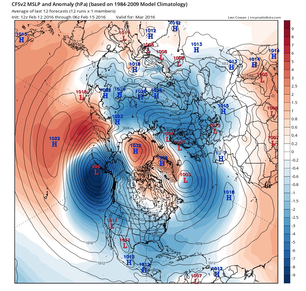
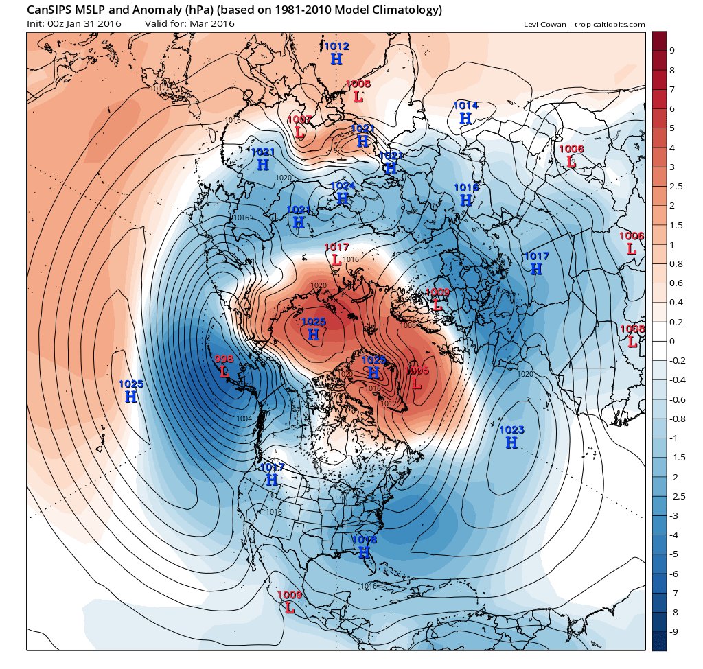
Also, believe it or not, there are signs that the NAO may finally go negative as we head into March. The Climate Forecast System Models and the GFS 500 mb run from yesterday, out 180 hours, posted below are all hinting at substantial ridging (blocking pattern) directly over Greenland and up near the Arctic Circle by the start of March, which are prime indicators of an developing -NAO should the CFS models verify. If the CFS models verify, a potential of late season winter cold spells and winter storms across Eastern North America and the Eastern CONUS could be on the horizon for at least the first 1/2 of March. Will be monitoring this closely.
Yesterday's 12Z GFS 500 mb 180 hour valid 0Z 2/28/16

12Z GFS run for 12Z Wednesday 2/24/16
Also, believe it or not, there are signs that the NAO may finally go negative as we head into March. The Climate Forecast System Models and the GFS 500 mb run from yesterday, out 180 hours, posted below are all hinting at substantial ridging (blocking pattern) directly over Greenland and up near the Arctic Circle by the start of March, which are prime indicators of an developing -NAO should the CFS models verify. If the CFS models verify, a potential of late season winter cold spells and winter storms across Eastern North America and the Eastern CONUS could be on the horizon for at least the first 1/2 of March. Will be monitoring this closely.
Yesterday's 12Z GFS 500 mb 180 hour valid 0Z 2/28/16
0 likes
NEVER, EVER SAY NEVER in the tropics and weather in general, and most importantly, with life itself!!
________________________________________________________________________________________
Fay 2008 Beryl 2012 Debby 2012 Colin 2016 Hermine 2016 Julia 2016 Matthew 2016 Irma 2017 Dorian 2019
________________________________________________________________________________________
Fay 2008 Beryl 2012 Debby 2012 Colin 2016 Hermine 2016 Julia 2016 Matthew 2016 Irma 2017 Dorian 2019
-
HURRICANELONNY
- Category 5

- Posts: 1392
- Joined: Wed May 07, 2003 6:48 am
- Location: HOLLYWOOD.FL
Re: Florida Weather
Since no model held on to the line a week ago and were at the anniversary of a major tornado outbreak 18 years ago that killed many people in central fl.. We need to keep an eye out for severe weather on wednesday.
Question remains as to how this line holds together as it enters the
rest of South Florida. European model (ecmwf)/GFS do seem to break up this line
considerably Wednesday night as it moves southeast. Not sure if i'm
willing to buy into this solution completely, models may be
decreasing instability far too quickly overnight after a warm day.
This was a bias of the models with last week's severe weather
outbreak. It is possible that Storm Prediction Center will outlook other parts of South
Florida as the event nears, and we still need to watch for the potential
of strong thunderstorms across the entire region with this frontal
passage.
0 likes
hurricanelonny


Re: Florida Weather
Hey did the board fall asleep? There is possible severe weather for Florida next 12 hours or so?
0 likes
-
northjaxpro
- S2K Supporter
- Posts: 8900
- Joined: Mon Sep 27, 2010 11:21 am
- Location: Jacksonville, FL
Re: Florida Weather
I am here following the severe weather tonight. Tornadoes have already affected the Pensacola area and much of the western Florida Panhandle counties are under tornado warnings currently. There will be the risk for more severe weather overnight into Wednesday morning as another squall line will develop and move across North Florida during the next 12 hours. The threat may possibly occur farther down the peninsula later during the day Wednesday.
0 likes
NEVER, EVER SAY NEVER in the tropics and weather in general, and most importantly, with life itself!!
________________________________________________________________________________________
Fay 2008 Beryl 2012 Debby 2012 Colin 2016 Hermine 2016 Julia 2016 Matthew 2016 Irma 2017 Dorian 2019
________________________________________________________________________________________
Fay 2008 Beryl 2012 Debby 2012 Colin 2016 Hermine 2016 Julia 2016 Matthew 2016 Irma 2017 Dorian 2019
-
northjaxpro
- S2K Supporter
- Posts: 8900
- Joined: Mon Sep 27, 2010 11:21 am
- Location: Jacksonville, FL
Re: Florida Weather
Squall line now developing from south of Columbus, GA southward through the Eastern Florida Panhandle into the GOM. This is the squall line to watch overnight into the wee hours up to sunrise as it moves east/northeast across Georgia and Northern Florida.
0 likes
NEVER, EVER SAY NEVER in the tropics and weather in general, and most importantly, with life itself!!
________________________________________________________________________________________
Fay 2008 Beryl 2012 Debby 2012 Colin 2016 Hermine 2016 Julia 2016 Matthew 2016 Irma 2017 Dorian 2019
________________________________________________________________________________________
Fay 2008 Beryl 2012 Debby 2012 Colin 2016 Hermine 2016 Julia 2016 Matthew 2016 Irma 2017 Dorian 2019
-
northjaxpro
- S2K Supporter
- Posts: 8900
- Joined: Mon Sep 27, 2010 11:21 am
- Location: Jacksonville, FL
Re: Florida Weather
Tornado warning currently for Bay County, which includes the Panama City area.
0 likes
NEVER, EVER SAY NEVER in the tropics and weather in general, and most importantly, with life itself!!
________________________________________________________________________________________
Fay 2008 Beryl 2012 Debby 2012 Colin 2016 Hermine 2016 Julia 2016 Matthew 2016 Irma 2017 Dorian 2019
________________________________________________________________________________________
Fay 2008 Beryl 2012 Debby 2012 Colin 2016 Hermine 2016 Julia 2016 Matthew 2016 Irma 2017 Dorian 2019
-
northjaxpro
- S2K Supporter
- Posts: 8900
- Joined: Mon Sep 27, 2010 11:21 am
- Location: Jacksonville, FL
Re: Florida Weather
Broken squall line extending from South Carolina to SE Georgia, southwest through North Florida to the mouth of the Suwannee River. This line should make it through the Jax metro area from 8 a.m. - 11: a.m. this morning.
Will be on the alert for strong rotating cells as this line moves through later this morning.
Will be on the alert for strong rotating cells as this line moves through later this morning.
0 likes
NEVER, EVER SAY NEVER in the tropics and weather in general, and most importantly, with life itself!!
________________________________________________________________________________________
Fay 2008 Beryl 2012 Debby 2012 Colin 2016 Hermine 2016 Julia 2016 Matthew 2016 Irma 2017 Dorian 2019
________________________________________________________________________________________
Fay 2008 Beryl 2012 Debby 2012 Colin 2016 Hermine 2016 Julia 2016 Matthew 2016 Irma 2017 Dorian 2019
Re: Florida Weather
The squall line is a little earlier than forecast. Just when the pools in the backyard were finally receding we get another rain injection. Thank goodness it seems to be a limited one. A few cool days to follow.
0 likes
-
HURRICANELONNY
- Category 5
- Posts: 1392
- Joined: Wed May 07, 2003 6:48 am
- Location: HOLLYWOOD.FL
Re: Florida Weather
Good news. Didn't see any severe weather for broward on radar. No red. Just some yellow and green. Lets hope it stays that way. 
http://radar.weather.gov/ridge/radar.ph ... 1&loop=yes
I must admit. The models were right. Convection split off. I thought for sure I'd get something. Now I'm wondering if I'll even get any rain.
Oh well. Nice little line came through. Now some nice cool weather.
http://radar.weather.gov/ridge/radar.ph ... 1&loop=yes
I must admit. The models were right. Convection split off. I thought for sure I'd get something. Now I'm wondering if I'll even get any rain.
Oh well. Nice little line came through. Now some nice cool weather.
0 likes
hurricanelonny
-
northjaxpro
- S2K Supporter
- Posts: 8900
- Joined: Mon Sep 27, 2010 11:21 am
- Location: Jacksonville, FL
Re: Florida Weather
Currently 32 degrees at my home base this morning. Most areas inland across North Florida are in the 30-35 degree range, except for areas along the Saint Johns River and out at the beaches, where temps in those areas are generally near 40 degrees. Also a good amount of frost around this morning. This is the ninth freeze at my home base measured this season. Also, right on schedule as typically the last freeze of the season on average is late February - early March in these neck of the woods. Yeah, spring is just around the corner indeed.
Another beautiful weekend shaping up for the region with no rain in sight for the next several days as High Pressure sitting right over the area is in complete control. One more day of slightly below average temps with highs today in the Jax area in the mid 60s. Low temps Sunday morning here expected in the mid 30s with more frost. Max temp Sunday should make it to 70 degrees. Beautiful weather everyone so get out and enjoy it.
Another beautiful weekend shaping up for the region with no rain in sight for the next several days as High Pressure sitting right over the area is in complete control. One more day of slightly below average temps with highs today in the Jax area in the mid 60s. Low temps Sunday morning here expected in the mid 30s with more frost. Max temp Sunday should make it to 70 degrees. Beautiful weather everyone so get out and enjoy it.
0 likes
NEVER, EVER SAY NEVER in the tropics and weather in general, and most importantly, with life itself!!
________________________________________________________________________________________
Fay 2008 Beryl 2012 Debby 2012 Colin 2016 Hermine 2016 Julia 2016 Matthew 2016 Irma 2017 Dorian 2019
________________________________________________________________________________________
Fay 2008 Beryl 2012 Debby 2012 Colin 2016 Hermine 2016 Julia 2016 Matthew 2016 Irma 2017 Dorian 2019
Re: Florida Weather
I'm thinking back to my answer on the "guess the first freeze" thread. It was one word..."none". and it was a correct guess. we didn't even come close. we've now gone several consecutive winters (I've lost count on the exact number) without a single freeze. Tampa should get several freezes per year so this is a remarkable streak.
0 likes
-
northjaxpro
- S2K Supporter
- Posts: 8900
- Joined: Mon Sep 27, 2010 11:21 am
- Location: Jacksonville, FL
Re: Florida Weather
Although we have had freezes here at my locale (9 total so far this season counting yesterday morning), this marks the seventh conseutive year in which we have had well below the average total of freezes here in Jax, which is typically 16 per winter season. So, we all have benefited from not having severe winters since 2009-10, thanks mainly because we have not had a prolonged negative NAO in winter since 2009-10 season.
0 likes
NEVER, EVER SAY NEVER in the tropics and weather in general, and most importantly, with life itself!!
________________________________________________________________________________________
Fay 2008 Beryl 2012 Debby 2012 Colin 2016 Hermine 2016 Julia 2016 Matthew 2016 Irma 2017 Dorian 2019
________________________________________________________________________________________
Fay 2008 Beryl 2012 Debby 2012 Colin 2016 Hermine 2016 Julia 2016 Matthew 2016 Irma 2017 Dorian 2019
Re: Florida Weather
The sun is now at a high enough level to make these cool days pleasurable.
0 likes
-
TheStormExpert
Re: Florida Weather
Happy Meteorlogical First Day of Spring everyone! 
For my location just north of West Palm Beach, FL the period of December 2015-February 2016 seemed rather mild and wet with dry periods especially during the second half of February where it seems the rather active El Niño pattern we were in during December, January, and the very beginning of February fizzled out leaving us in a more cooler and drier than average period. Temperatures started out MUCH warmer than average during all of December followed by a cooler than average January and February. Fortunately the NAO never went truly negative or it would have been much colder than average for the January/February period.
Looking ahead during the next two weeks, the NAO looks to very gradually trend nuetral to almost negative, the AO goes and stays negative with ups and downs, and the PNA starts to trend negative. The CPC temperature outlooks calls for a Above Average period for most of the Lower 48 including all of Florida now. Preciptation wise things MAY start out slightly wetter than average then trend back to drier than average conditions.
This afternoon you can already see the East Coast Sea Breeze trying to establish itself and push inland here in Coastal Palm Beach County as if it were almost the start of the Rainy Season. Still have a ways to go until that but I thought that was interesting to observe.
0 likes
-
HURRICANELONNY
- Category 5
- Posts: 1392
- Joined: Wed May 07, 2003 6:48 am
- Location: HOLLYWOOD.FL
Re: Florida Weather
A little off topic. But does anyone know what the signals were before the super storm of 92 formed. Like the NAO/AO/PNA etc. Kind of curious. Not that I think were due for a storm of that magnitude this march. But just wondering.
0 likes
hurricanelonny

Re: Florida Weather
HURRICANELONNY wrote:A little off topic. But does anyone know what the signals were before the super storm of 92 formed. Like the NAO/AO/PNA etc. Kind of curious. Not that I think were due for a storm of that magnitude this march. But just wondering.
It was March 1993 not '92.
Sypnotics were +PNA, & -NAO just prior to the storm forming.
It was indeed a once in a lifetime storm. I was working in downtown New Orleans that Friday night, glass shattered in some of the high rises that night, the wind was unbelievable, drove home that night with big snow flurries falling right at the end of the precipitation ending.
http://www.srh.noaa.gov/tlh/?n=march1993_superstorm
0 likes
-
northjaxpro
- S2K Supporter
- Posts: 8900
- Joined: Mon Sep 27, 2010 11:21 am
- Location: Jacksonville, FL
Re: Florida Weather
I have stated on several occasions on this forum that the March 1993 Superstorm ranks as one of my greatest weather events I have ever covered and experienced in my lifetime. An incredible weather event for the ages!! That storm gave us everything here across the Jax area in 24-36 hours time: severe weather and tornadoes in Northeast Florida, wind gusts over 50 mph, coastal flooding over the Big Bend region (12 feet storm surge in Apalachee Bay) then as the rapidly intensifying Low passed by us to the north and up the East Coast, temps plummeted we had light snow and blustery conditions 30-40 mph wind gusts and record low temps into the upper 20s on that Saturday morning 3/14/93.
0 likes
NEVER, EVER SAY NEVER in the tropics and weather in general, and most importantly, with life itself!!
________________________________________________________________________________________
Fay 2008 Beryl 2012 Debby 2012 Colin 2016 Hermine 2016 Julia 2016 Matthew 2016 Irma 2017 Dorian 2019
________________________________________________________________________________________
Fay 2008 Beryl 2012 Debby 2012 Colin 2016 Hermine 2016 Julia 2016 Matthew 2016 Irma 2017 Dorian 2019
Re: Florida Weather
Shoveled a lot of snow from my driveway from that superstorm in New York.
Warm trend here. Finally drying out.
Warm trend here. Finally drying out.
0 likes
Return to “USA & Caribbean Weather”
Who is online
Users browsing this forum: AnnularCane, Brent, Cpv17, Iceresistance, Stratton23, txtwister78 and 23 guests