Florida Weather
Moderator: S2k Moderators
Forum rules

The posts in this forum are NOT official forecast and should not be used as such. They are just the opinion of the poster and may or may not be backed by sound meteorological data. They are NOT endorsed by any professional institution or STORM2K.

Re: Florida Weather
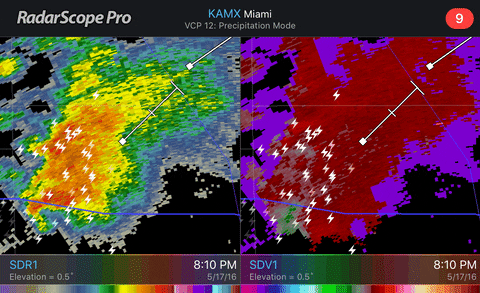
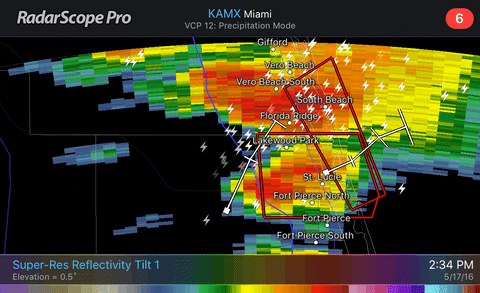
I am surprised we are not seeing more tornado warnings out of some of these cells this afternoon with some rotations noticed on radar.
0 likes
-
TheStormExpert
Re: Florida Weather
Welocme to the 2016 Florida Rainy Season folks! 


With Dewpoints being in the low/mid even upper 70's all day it seems the Flordia Rainy Season is underway.


With Dewpoints being in the low/mid even upper 70's all day it seems the Flordia Rainy Season is underway.
0 likes
-
gatorcane

- S2K Supporter

- Posts: 23708
- Age: 48
- Joined: Sun Mar 13, 2005 3:54 pm
- Location: Boca Raton, FL
Re: Florida Weather
Yes rainy season but the pattern still looks quite El-Nino like as these strong shortwaves traverse east in the westerlies.
0 likes
-
TheStormExpert
Re: Florida Weather
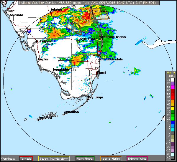
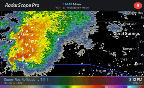
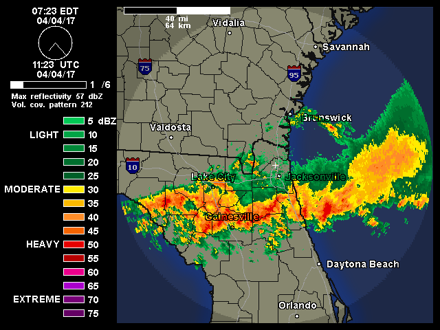
Nice little hook echo in western rural Broward County several hours ago just west of Coral Springs and Sunrise.
0 likes
-
TheStormExpert
Re: Florida Weather
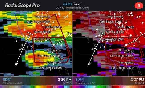
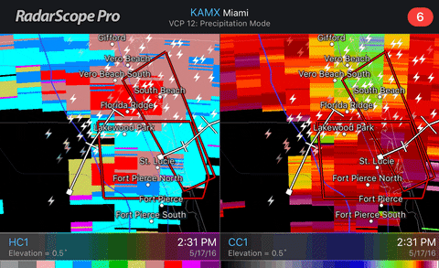
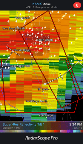
Possible Tornado just west of Port Saint Lucie/Fort Pierce earlier this afternoon.
0 likes
Re: Florida Weather
NDG wrote:Over 2" of rain in my neighborhood this afternoon.
I take that back, it was 4" of rain that j got this afternoon and evening.
0 likes
-
northjaxpro

- S2K Supporter
- Posts: 8900
- Joined: Mon Sep 27, 2010 11:21 am
- Location: Jacksonville, FL
Re: Florida Weather
Yes indeed, my wish earlier this week apparently has been granted by the weather gods. Yesterday 2.7 inches of rain fell here through midnight, so yeah, the rainy season has finally kicked off after a very dry first half of May here in Jax. It was very welcomed relief as the lawn was getting brown.
0 likes
NEVER, EVER SAY NEVER in the tropics and weather in general, and most importantly, with life itself!!
________________________________________________________________________________________
Fay 2008 Beryl 2012 Debby 2012 Colin 2016 Hermine 2016 Julia 2016 Matthew 2016 Irma 2017 Dorian 2019
________________________________________________________________________________________
Fay 2008 Beryl 2012 Debby 2012 Colin 2016 Hermine 2016 Julia 2016 Matthew 2016 Irma 2017 Dorian 2019
Re: Florida Weather
Here's a video I took of the monsoon like nonstop rains we got between 5:30 & 9 PM.

0 likes
-
TheStormExpert
Re: Florida Weather
Another stormy afternoon along the SE Florida Coastline with most of the action being in Palm Beach and Broward Counties.
0 likes
-
tropicwatch

- Category 5

- Posts: 3426
- Age: 62
- Joined: Sat Jun 02, 2007 10:01 am
- Location: The Villages, Florida
- Contact:
Re: Florida Weather
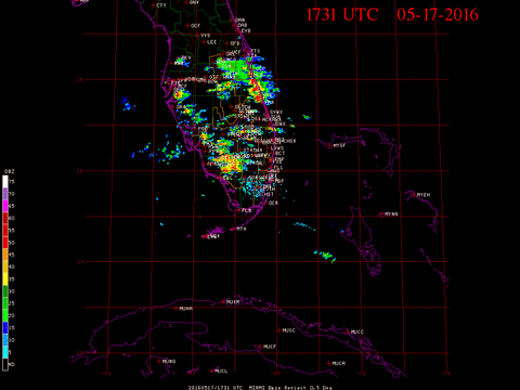
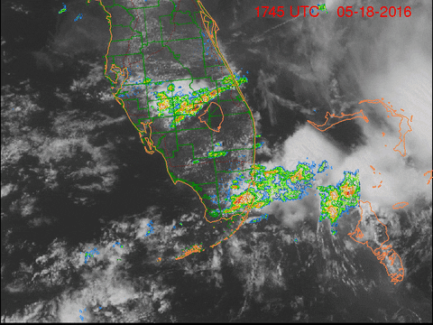
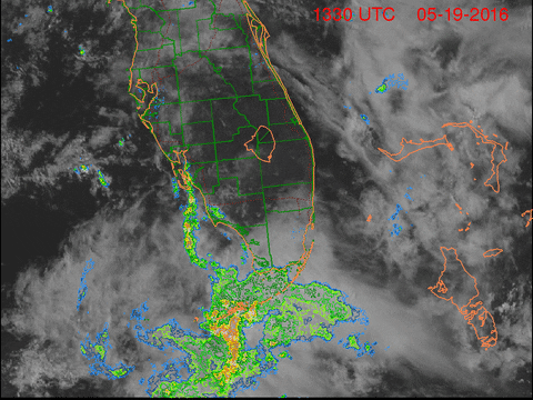
Looks like an eddy of low pressure in the Florida straits.
0 likes
Tropicwatch
Agnes 72', Eloise 75, Elena 85', Kate 85', Charley 86', Florence 88', Beryl 94', Dean 95', Erin 95', Opal 95', Earl 98', Georges 98', Ivan 2004', Arlene 2005', Dennis 2005', Ida 2009' Debby 2012' Irma 2017' Michael 2018'
Agnes 72', Eloise 75, Elena 85', Kate 85', Charley 86', Florence 88', Beryl 94', Dean 95', Erin 95', Opal 95', Earl 98', Georges 98', Ivan 2004', Arlene 2005', Dennis 2005', Ida 2009' Debby 2012' Irma 2017' Michael 2018'
-
TheStormExpert
Re: Florida Weather
panamatropicwatch wrote:Looks like an eddy of low pressure in the Florida straits.
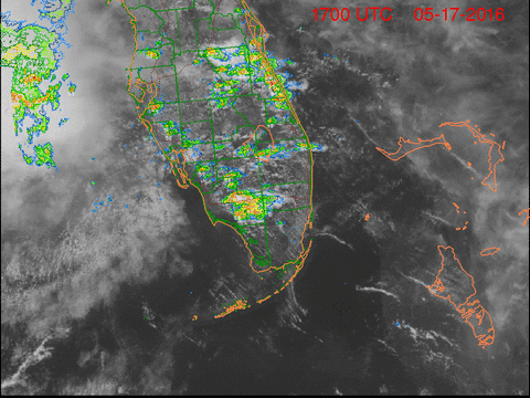
Shows up nicely just west of Dry Tortugas and Key West on the Satellite/Radar Composite.
0 likes
-
northjaxpro
- S2K Supporter
- Posts: 8900
- Joined: Mon Sep 27, 2010 11:21 am
- Location: Jacksonville, FL
Re: Florida Weather
Thanks to ex-Bonnie still spinning over Eastern SC, we continue to be in the subsident air on the southwest side of the decaying cyclone. We have had a beautiful, albeit hot and dry holiday weekend here in Northeast Florida. Temps reached 91.3 degrees at my home yesterday and expected to be about that again today. We are now in a stretch of 7 consecutive days without any measurable rainfall here. Also beginning to get dry again. We need rain soon. This week looks mostly dry here, but rain prospects look better long range. The models are bringing tropical moisture in from the Caribbean and GOM across the peninsula possibly late this week into the next weekend.
0 likes
NEVER, EVER SAY NEVER in the tropics and weather in general, and most importantly, with life itself!!
________________________________________________________________________________________
Fay 2008 Beryl 2012 Debby 2012 Colin 2016 Hermine 2016 Julia 2016 Matthew 2016 Irma 2017 Dorian 2019
________________________________________________________________________________________
Fay 2008 Beryl 2012 Debby 2012 Colin 2016 Hermine 2016 Julia 2016 Matthew 2016 Irma 2017 Dorian 2019
-
northjaxpro
- S2K Supporter
- Posts: 8900
- Joined: Mon Sep 27, 2010 11:21 am
- Location: Jacksonville, FL
Re: Florida Weather
Well, it looks like things are really going to begin to go downhill quickly across the Florida peninsula later this upcoming weekend through the early part of next week as the potential of a developing tropical cyclone looms big. I think using this thread for the NWS WFO AFDs across the state and local reports will prove quite useful in the coming days leading into next week.
So, to my fellow Storm2K ers across the peninsula, it looks to be a very interesting situation for this next 5-7 day period.
0 likes
NEVER, EVER SAY NEVER in the tropics and weather in general, and most importantly, with life itself!!
________________________________________________________________________________________
Fay 2008 Beryl 2012 Debby 2012 Colin 2016 Hermine 2016 Julia 2016 Matthew 2016 Irma 2017 Dorian 2019
________________________________________________________________________________________
Fay 2008 Beryl 2012 Debby 2012 Colin 2016 Hermine 2016 Julia 2016 Matthew 2016 Irma 2017 Dorian 2019

Re: Florida Weather
I just realized I can participate in here for the next couple months.  I'm excited to have a place to complain about afternoon thunderstorms!
0 likes
-
gatorcane
- S2K Supporter
- Posts: 23708
- Age: 48
- Joined: Sun Mar 13, 2005 3:54 pm
- Location: Boca Raton, FL
Re: Florida Weather
RL3AO wrote:I just realized I can participate in here for the next couple months.
Welcome and happy venting!
0 likes
-
northjaxpro
- S2K Supporter
- Posts: 8900
- Joined: Mon Sep 27, 2010 11:21 am
- Location: Jacksonville, FL
Re: Florida Weather
Below are the projected rainfall totals by WPC through 12Z Wednesday morning, 6/8/16. These projections are following along a swath of heavy rainfall right along the I-4 corridor, which is the anticipated track 93L/Colin is forecast to take during the day on Tuesday. Right now 6-8 inches of rainfall are forecasted along the I-4 corridor, with a near 8" bullseye over Tampa Bay. Meanwhile an average of 3-6 inches of rainfall are projected across portions of North and north Central peninsula, and also down across the Southern peninsula. Now, any deviation of the Low track could shift the heaviest rain north or southward. Thankfully, this system should get picked up by the upper trough, which will be positioned down into the Central GOM by Tuesday. The trough should carry 93L/Colin quickly across the peninsula on Tuesday and hopefully prevent a massive flood event, which occurred with Debby in 2012.
Nevertheless, a significant rain event in store for much of the peninsula during the next 96 hours.

Nevertheless, a significant rain event in store for much of the peninsula during the next 96 hours.
0 likes
NEVER, EVER SAY NEVER in the tropics and weather in general, and most importantly, with life itself!!
________________________________________________________________________________________
Fay 2008 Beryl 2012 Debby 2012 Colin 2016 Hermine 2016 Julia 2016 Matthew 2016 Irma 2017 Dorian 2019
________________________________________________________________________________________
Fay 2008 Beryl 2012 Debby 2012 Colin 2016 Hermine 2016 Julia 2016 Matthew 2016 Irma 2017 Dorian 2019
-
northjaxpro
- S2K Supporter
- Posts: 8900
- Joined: Mon Sep 27, 2010 11:21 am
- Location: Jacksonville, FL
Re: Florida Weather
The Tallahassee NWS mets calling for average 2-3" rainfall totals for thw Monday-Tuesday period, but possible 3-5" in the area of the SE Big Bend over in the Apalachee Bay region.
Meanwhile, on Sunday an area of low pressure is forecast to emerge
from the Yucatan peninsula, into the southeastern Gulf of Mexico.
The NHC has given this system a 70% chance of becoming a tropical
cyclone within the next 5 days. The forecast for this system is
complicated by the former of the low pressure systems mentioned
above. As the core of the northern stream low moves through the
northeastern quadrant of the country, it will loosely merge with
the low over Texas and result in an elongated trough over the
southeastern CONUS. The trough will likely introduce some enhanced
shear over the western part of the approaching tropical cyclone,
favoring more robust/persistent convection over the eastern half
of the storm. Most global and hires models are in decent agreement
with the idea that the cyclone will be quite asymmetrical. This
of course could have a significant impact on the eventual track of
the low. While models are split on just how far north or west the
cyclone will track initially, they all seem to pull the system
east pretty quickly under convection on the eastern periphery of
the storm. At this time, the local forecast will be for the low to
track across the northern peninsula of Florida sometime Monday
night into Tuesday morning. This would result in the heaviest rain
over our southeast Big Bend counties and across north-central
Florida. Reasonable average rainfall amounts over the southeast
Big Bend could be around 2-3", keeping in mind that an area of
3-5" could be displaced just southeast of our Big Bend counties.
However, both of the above advertised amounts are not expected to
result in any flooding concerns. A secondary concern could be some
minor coastal flooding across the Big Bend, though this is HIGHLY
dependent on what is currently an uncertain track of the yet to
develop low. In the wake of the low there is decent consensus
that rapid drying will occur, with a mostly dry day on Tuesday
under the current forecast.
0 likes
NEVER, EVER SAY NEVER in the tropics and weather in general, and most importantly, with life itself!!
________________________________________________________________________________________
Fay 2008 Beryl 2012 Debby 2012 Colin 2016 Hermine 2016 Julia 2016 Matthew 2016 Irma 2017 Dorian 2019
________________________________________________________________________________________
Fay 2008 Beryl 2012 Debby 2012 Colin 2016 Hermine 2016 Julia 2016 Matthew 2016 Irma 2017 Dorian 2019
-
northjaxpro
- S2K Supporter
- Posts: 8900
- Joined: Mon Sep 27, 2010 11:21 am
- Location: Jacksonville, FL
Re: Florida Weather
The current projections for Northeast Florida area by NWS Jax office is calling for localized amounts in excess of 2 inches, with the potential of 3-5 inches, with of course everything hinging on the exact track of the system.
0 likes
NEVER, EVER SAY NEVER in the tropics and weather in general, and most importantly, with life itself!!
________________________________________________________________________________________
Fay 2008 Beryl 2012 Debby 2012 Colin 2016 Hermine 2016 Julia 2016 Matthew 2016 Irma 2017 Dorian 2019
________________________________________________________________________________________
Fay 2008 Beryl 2012 Debby 2012 Colin 2016 Hermine 2016 Julia 2016 Matthew 2016 Irma 2017 Dorian 2019
Return to “USA & Caribbean Weather”
Who is online
Users browsing this forum: No registered users and 44 guests