Texas Fall 2013

U.S. & Caribbean Weather Discussions and Severe Weather Events

Moderator: S2k Moderators

Forum rules

The posts in this forum are NOT official forecast and should not be used as such. They are just the opinion of the poster and may or may not be backed by sound meteorological data. They are NOT endorsed by any professional institution or STORM2K.

Help Support Storm2K
Message
Author
aggiecutter
Category 5
Category 5
Posts: 1753
Joined: Thu Oct 14, 2004 9:22 pm
Location: Texarkana

Re: Texas Fall 2013

#1081 Postby aggiecutter » Sun Nov 24, 2013 12:46 pm

Texas Snowman wrote:Maybe I'm wrong, but this is starting to feel like a giant bust outside of the Panhandle and High Plains.


Looking at the 12z GFS(it should have a handle on things now) it appears that the main moisture axis will be along and east of I-35. Looks like the coastal low will rob most of the moisture from points west of there.

NOT an official forecast and should not be used as such. It is just the opinion of the poster
0 likes   

sooner101
Tropical Depression
Tropical Depression
Posts: 72
Joined: Fri Nov 22, 2013 1:02 pm
Location: Carrollton

#1082 Postby sooner101 » Sun Nov 24, 2013 12:46 pm

very light sleet coming down on carrollton plano border
0 likes   

User avatar
Ntxw
Storm2k Moderator
Storm2k Moderator
Posts: 22785
Joined: Wed Oct 21, 2009 6:34 pm
Location: DFW, Texas

Re: Texas Fall 2013

#1083 Postby Ntxw » Sun Nov 24, 2013 12:48 pm

I'd like to report that the official North Texas Branch of PWC has received the first sleet pellets of the winter season off Bush tollway east side of the Airport.
Last edited by Ntxw on Sun Nov 24, 2013 12:48 pm, edited 1 time in total.
0 likes   
The above post and any post by Ntxw is NOT an official forecast and should not be used as such. It is just the opinion of the poster and may or may not be backed by sound meteorological data. It is NOT endorsed by any professional institution including Storm2k. For official information, please refer to NWS products.

  Help support Storm2K!
Help Support Storm2K

User avatar
SouthernMet
Category 3
Category 3
Posts: 857
Joined: Sun Aug 29, 2010 8:23 pm
Location: fort worth, tx

Re: Texas Fall 2013

#1084 Postby SouthernMet » Sun Nov 24, 2013 12:48 pm

Texas Snowman wrote:Maybe I'm wrong, but this is starting to feel like a giant bust outside of the Panhandle and High Plains.


Remember this is just the first round of 3. Stay tuned, the main event is still to come.
Models still showing impressive QPF totals for I-35 corridor for tonight/tomorrow morning, potentially dangerous situation when you are below freezing getting heavy ice/sleet for multiple hours.
0 likes   
Nothing that SouthernMet posts, is an official forecast,nor does it reflect views of STORM2K.. SouthernMet is just adding to the great discussions on STORM2K.. Refer to NWS for official forecasts.

User avatar
Portastorm
Storm2k Moderator
Storm2k Moderator
Posts: 9914
Age: 63
Joined: Fri Jul 11, 2003 9:16 am
Location: Round Rock, TX
Contact:

Re:

#1085 Postby Portastorm » Sun Nov 24, 2013 12:49 pm

aggiecutter wrote:Currently in Texarkana it is 33 degrees with a dewpoint of 15. All the 12z runs of the models have a QPF output of 1-1.25" of precip for the Texarkana area. I don't need JB or Portastorm(one in the same) to tell me that equals a significant ice storm for this area.


Look who finally woke up and realized a winter storm was upon us! :P

We all should move to Texarkana!
0 likes   
Any forecasts under my name are to be taken with a grain of salt. Get your best forecasts from the National Weather Service and National Hurricane Center.

User avatar
Longhornmaniac8
Category 1
Category 1
Posts: 254
Joined: Thu Nov 18, 2010 2:30 am
Location: Austin, TX

Re: Texas Fall 2013

#1086 Postby Longhornmaniac8 » Sun Nov 24, 2013 12:54 pm

Porta, have you been noticing dew points rising over the last hour or so? Is this expected after a rain event like that?

Cheers,
Cameron
0 likes   

aggiecutter
Category 5
Category 5
Posts: 1753
Joined: Thu Oct 14, 2004 9:22 pm
Location: Texarkana

Re: Re:

#1087 Postby aggiecutter » Sun Nov 24, 2013 12:56 pm

Portastorm wrote:
aggiecutter wrote:Currently in Texarkana it is 33 degrees with a dewpoint of 15. All the 12z runs of the models have a QPF output of 1-1.25" of precip for the Texarkana area. I don't need JB or Portastorm(one in the same) to tell me that equals a significant ice storm for this area.


Look who finally woke up and realized a winter storm was upon us! :P

We all should move to Texarkana!


I don't know about that. The Christmas ice storm of 2000 was pretty devastating. I was without power for 8 days, not fun at all. BTW, enjoy the weather, its the only weather you've got.
0 likes   

User avatar
TeamPlayersBlue
Category 5
Category 5
Posts: 3445
Joined: Tue Feb 02, 2010 1:44 am
Location: Denver/Applewood, CO

#1088 Postby TeamPlayersBlue » Sun Nov 24, 2013 12:57 pm

Dewpoint 15 in Texarkana? :eek: Wow. Its still dropping here in SL, ready to see this next moisture plume. Im guessing as it hits eastern NM things will really fire up
0 likes   
Personal Forecast Disclaimer:
The posts in this forum are NOT official forecast and should not be used as such. They are just the opinion of the poster and may or may not be backed by sound meteorological data. They are NOT endorsed by any professional institution or storm2k.org. For official information, please refer to the NHC and NWS products.

BigB0882
S2K Supporter
S2K Supporter
Posts: 2284
Joined: Thu Jul 03, 2003 12:08 am
Location: Baton Rouge, LA
Contact:

#1089 Postby BigB0882 » Sun Nov 24, 2013 1:01 pm

Is there any chance of any wintry precipitation in Southeast Louisiana Tuesday night? I notice we have a good chance of rain Tuesday (100%) but I don't know when that rain is supposed to end. Our low for that night has gone from 37 to 35 so we are only 3 degrees away from hitting the freezing mark at the surface.
0 likes   

User avatar
iorange55
Category 5
Category 5
Posts: 2388
Joined: Thu Nov 13, 2008 9:47 pm
Location: Big D

Re: Texas Fall 2013

#1090 Postby iorange55 » Sun Nov 24, 2013 1:04 pm

Looks like the first band of precip split DFW in half. This was expected to be the weakest band, though. Hard to call this a "bust" yet.

We'll see what happens tonight, hopefully we stay away from the freezing rain.
0 likes   

WeatherNewbie
Tropical Storm
Tropical Storm
Posts: 231
Joined: Mon Mar 22, 2010 3:42 pm
Location: Richardson, Texas

Re: Texas Fall 2013

#1091 Postby WeatherNewbie » Sun Nov 24, 2013 1:10 pm

first sleet pellets just started coming down in richardson.
0 likes   
The above post is NOT an official forecast and should not be used as such. It is just the opinion of the poster and may or may not be backed by sound meteorological data. It is NOT endorsed by any professional institution including storm2k.org. For official information, please refer to NWS products.

sooner101
Tropical Depression
Tropical Depression
Posts: 72
Joined: Fri Nov 22, 2013 1:02 pm
Location: Carrollton

Re: Texas Fall 2013

#1092 Postby sooner101 » Sun Nov 24, 2013 1:11 pm

Pretty decent sleet and rain coming down off of Frankford and the tollway on carrollton/dallas border
0 likes   

downsouthman1
Category 2
Category 2
Posts: 663
Age: 45
Joined: Fri Jan 07, 2011 8:14 pm
Location: Rowlett, TX

Re: Texas Fall 2013

#1093 Postby downsouthman1 » Sun Nov 24, 2013 1:12 pm

iorange55 wrote:Looks like the first band of precip split DFW in half. This was expected to be the weakest band, though. Hard to call this a "bust" yet.

We'll see what happens tonight, hopefully we stay away from the freezing rain.

Yes. Way too early to call this a bust. The dynamics are coming into place. This 1st batch needed to come through to create the wet-bulb effect. It is doing exactly what it was forecast to do. Considering that almost all of yesterday's late-day NAM runs actually showed the batch dissipate before it made it, we are now in a worse condition as a result of the fact that the models initialized the batch incorrectly. As a result, the atmosphere is now more primed than those models thought for a significant event.

Keep an eye on the development on radar west of San Angelo & over Sonora. It may break the expected lull in activity or grow upscale & launch the next wave.
Last edited by downsouthman1 on Sun Nov 24, 2013 1:14 pm, edited 1 time in total.
0 likes   
Not a professional MET! My posts are merely speculation.

User avatar
iorange55
Category 5
Category 5
Posts: 2388
Joined: Thu Nov 13, 2008 9:47 pm
Location: Big D

Re: Texas Fall 2013

#1094 Postby iorange55 » Sun Nov 24, 2013 1:13 pm

Finally getting some sleet here in the Cedar Hill area.
0 likes   

User avatar
Rgv20
S2K Supporter
S2K Supporter
Posts: 2466
Age: 38
Joined: Wed Jan 05, 2011 5:42 pm
Location: Edinburg/McAllen Tx

#1095 Postby Rgv20 » Sun Nov 24, 2013 1:13 pm

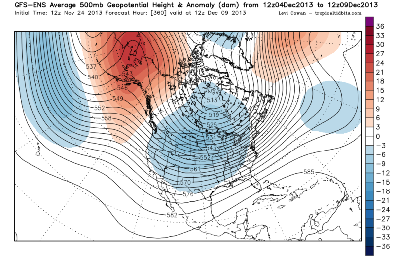
I know this may be a bit off topic with the current winter weather happening right now but just an update on the long range weather....GFS Ensembles and ECMWF Ensembles continue to hint at a stormy pattern in the long range. We could see another cold outbreak around the second week of December.


Look at that blocking in Alaska! in the 11-15 days, ECMWF Ensembles are similar in this time frame.

Image
0 likes   
The following post is NOT an official forecast and should not be used as such. It is just the opinion of the poster and may or may not be backed by sound meteorological data. It is NOT endorsed by any professional institution including storm2k.org For Official Information please refer to the NHC and NWS products.

User avatar
Longhornmaniac8
Category 1
Category 1
Posts: 254
Joined: Thu Nov 18, 2010 2:30 am
Location: Austin, TX

Re: Texas Fall 2013

#1096 Postby Longhornmaniac8 » Sun Nov 24, 2013 1:14 pm

downsouthman1 wrote:
iorange55 wrote:Looks like the first band of precip split DFW in half. This was expected to be the weakest band, though. Hard to call this a "bust" yet.

We'll see what happens tonight, hopefully we stay away from the freezing rain.

Yes. Way too early to call this a bust. The dynamics are coming into place. This 1st batch needed to come through to create the wet-bulb effect. It is doing exactly what it was forecast to do. Considering that almost all of yesterday's late-day NAM runs actually showed the batch dissipate before it made it, we are now in a worse condition as a result of the fact that the models initialized the batch incorrectly. As a result, the atmosphere is now more primed than those models thought for a significant event.


We'll need more wet bulbing down here to make it to freezing! Closest I got was 35.4.

Cheers,
Cameron
0 likes   

downsouthman1
Category 2
Category 2
Posts: 663
Age: 45
Joined: Fri Jan 07, 2011 8:14 pm
Location: Rowlett, TX

Re: Texas Fall 2013

#1097 Postby downsouthman1 » Sun Nov 24, 2013 1:15 pm

Longhornmaniac8 wrote:
downsouthman1 wrote:
iorange55 wrote:Looks like the first band of precip split DFW in half. This was expected to be the weakest band, though. Hard to call this a "bust" yet.

We'll see what happens tonight, hopefully we stay away from the freezing rain.

Yes. Way too early to call this a bust. The dynamics are coming into place. This 1st batch needed to come through to create the wet-bulb effect. It is doing exactly what it was forecast to do. Considering that almost all of yesterday's late-day NAM runs actually showed the batch dissipate before it made it, we are now in a worse condition as a result of the fact that the models initialized the batch incorrectly. As a result, the atmosphere is now more primed than those models thought for a significant event.


We'll need more wet bulbing down here to make it to freezing! Closest I got was 35.4.

Cheers,
Cameron

This is the beginning. This is a progressive storm system. Not a one-shot & you're out kind of deal.
0 likes   
Not a professional MET! My posts are merely speculation.

User avatar
Ntxw
Storm2k Moderator
Storm2k Moderator
Posts: 22785
Joined: Wed Oct 21, 2009 6:34 pm
Location: DFW, Texas

Re:

#1098 Postby Ntxw » Sun Nov 24, 2013 1:16 pm

Rgv20 wrote:I know this may be a bit off topic with the current winter weather happening right now but just an update on the long range weather....GFS Ensembles and ECMWF Ensembles continue to hint at a stormy pattern in the long range. We could see another cold outbreak around the second week of December.


Look at that blocking in Alaska! in the 11-15 days, ECMWF Ensembles are similar in this time frame.


Check your PM RGV20
0 likes   
The above post and any post by Ntxw is NOT an official forecast and should not be used as such. It is just the opinion of the poster and may or may not be backed by sound meteorological data. It is NOT endorsed by any professional institution including Storm2k. For official information, please refer to NWS products.


  Help support Storm2K!

Help Support Storm2K


User avatar
TrekkerCC
S2K Supporter
S2K Supporter
Posts: 263
Joined: Sat Sep 06, 2003 10:19 pm
Location: North Central Texas (Dallas Area)

Re: Texas Fall 2013

#1099 Postby TrekkerCC » Sun Nov 24, 2013 1:20 pm

I also confirm some light sleet here (plano area).
0 likes   
Storm2K Forecast Disclaimer:

This post is NOT AN OFFICIAL FORECAST and should not be used as such. It is just the opinion of the poster and may or may not be backed by sound meteorological data. It is NOT endorsed by any professional institution including storm2k.org. For Official Information please refer to the NHC and NWS products.

User avatar
gboudx
S2K Supporter
S2K Supporter
Posts: 4080
Joined: Thu Sep 04, 2003 1:39 pm
Location: Rockwall, Tx but from Harvey, La

#1100 Postby gboudx » Sun Nov 24, 2013 1:21 pm

So far only light rain in Rockwall. Temp 33.
0 likes   


Return to “USA & Caribbean Weather”

Who is online

Users browsing this forum: No registered users and 13 guests