Texas Spring 2022
Moderator: S2k Moderators
Forum rules

The posts in this forum are NOT official forecast and should not be used as such. They are just the opinion of the poster and may or may not be backed by sound meteorological data. They are NOT endorsed by any professional institution or STORM2K.
-
ElectricStorm

- Category 5

- Posts: 5146
- Age: 25
- Joined: Tue Aug 13, 2019 11:23 pm
- Location: Norman, OK
Re: Texas Spring 2022
Tornado emergency north of Little Rock. Monster on the ground
0 likes
B.S Meteorology, University of Oklahoma '25
Please refer to the NHC, NWS, or SPC for official information.
Please refer to the NHC, NWS, or SPC for official information.


Re: Texas Spring 2022
Weather Dude wrote:Tornado emergency north of Little Rock. Monster on the ground
That's one heck of a signature on radar, one of the scariest this year thus far.
0 likes
The above post and any post by Ntxw is NOT an official forecast and should not be used as such. It is just the opinion of the poster and may or may not be backed by sound meteorological data. It is NOT endorsed by any professional institution including Storm2k. For official information, please refer to NWS products.
Help support Storm2K!
-
ElectricStorm
- Category 5
- Posts: 5146
- Age: 25
- Joined: Tue Aug 13, 2019 11:23 pm
- Location: Norman, OK
Re: Texas Spring 2022
Ntxw wrote:Weather Dude wrote:Tornado emergency north of Little Rock. Monster on the ground
That's one heck of a signature on radar, one of the scariest this year thus far.
Yeah for sure. Not too far away from where the 2014 monster tracked
0 likes
B.S Meteorology, University of Oklahoma '25
Please refer to the NHC, NWS, or SPC for official information.
Please refer to the NHC, NWS, or SPC for official information.
-
rwfromkansas
- Category 5
- Posts: 3032
- Joined: Sat Aug 27, 2005 12:47 am
- Location: North Fort Worth
Re: Texas Spring 2022
I just saw a GIF of the tornado on FB. One of the craziest tornadoes I've ever seen. Gorgeous symmetrical area of debris encircling the main funnel. Hopefully it dissipates though..
0 likes
-
cheezyWXguy

- Category 5
- Posts: 6282
- Joined: Mon Feb 13, 2006 12:29 am
- Location: Dallas, TX
Re: Texas Spring 2022
rwfromkansas wrote:I just saw a GIF of the tornado on FB. One of the craziest tornadoes I've ever seen. Gorgeous symmetrical area of debris encircling the main funnel. Hopefully it dissipates though..
Can you link it? I must’ve missed the peak on radar because I never saw an especially prominent debris signature
0 likes
Re: Texas Spring 2022
cheezyWXguy wrote:rwfromkansas wrote:I just saw a GIF of the tornado on FB. One of the craziest tornadoes I've ever seen. Gorgeous symmetrical area of debris encircling the main funnel. Hopefully it dissipates though..
Can you link it? I must’ve missed the peak on radar because I never saw an especially prominent debris signature
As it went over Mayflower and around Cato, Arkansas it was a classic hook with debris ball. It's probably been cycling since then.
0 likes
The above post and any post by Ntxw is NOT an official forecast and should not be used as such. It is just the opinion of the poster and may or may not be backed by sound meteorological data. It is NOT endorsed by any professional institution including Storm2k. For official information, please refer to NWS products.
Help support Storm2K!
Help support Storm2K!
-
bubba hotep

- S2K Supporter

- Posts: 6014
- Joined: Wed Dec 28, 2016 1:00 am
- Location: Collin County Texas
Re: Texas Spring 2022
00z HRRR fires storms off the dryline and sends them NE through N. TX tomorrow but keeps Oklahoma mostly calm.
0 likes
Winter time post are almost exclusively focused on the DFW area.
-
rwfromkansas
- Category 5
- Posts: 3032
- Joined: Sat Aug 27, 2005 12:47 am
- Location: North Fort Worth
Re: Texas Spring 2022
I think it wasn't that tornado since it was too light. Can't find the post anymore anyway.
0 likes
Re: Texas Spring 2022
bubba hotep wrote:00z HRRR fires storms off the dryline and sends them NE through N. TX tomorrow but keeps Oklahoma mostly calm.
Tomorrow will be more favorable for initiation. Fairly potent shortwave, should be a few big supercells during peak. Hard to pinpoint where it fires off but more likely than today. I'd say just S/SE of DFW hot zone tomorrow.
2 likes
The above post and any post by Ntxw is NOT an official forecast and should not be used as such. It is just the opinion of the poster and may or may not be backed by sound meteorological data. It is NOT endorsed by any professional institution including Storm2k. For official information, please refer to NWS products.
Help support Storm2K!
Help support Storm2K!
-
txtwister78

- Category 5
- Posts: 2176
- Joined: Wed Jan 30, 2019 12:56 pm
- Location: San Antonio
Re: Texas Spring 2022
Definitely seeing a trend with the 0z HI-RES models (FV3, 3k NAM, WRF-NSSL and WRF-ARW2) tonight of some southward development along the dryline late afternoon tomorrow down into the SA/AUS region as well. Expecting those to be more isolated but with afternoon temps potentially climbing into the 90's, I think we should see the cap break here with some potentially big hailers with any storm that manages to fire (although isolated).
I wouldn't be surprised to see SPC extend the significant hatched area for hail down into the SA region in the next update based on model trends.
I wouldn't be surprised to see SPC extend the significant hatched area for hail down into the SA region in the next update based on model trends.
3 likes
-
cheezyWXguy
- Category 5
- Posts: 6282
- Joined: Mon Feb 13, 2006 12:29 am
- Location: Dallas, TX
Re: Texas Spring 2022
The nam is out to lunch with those surface temps tomorrow afternoon. Shows Dallas at 74 at 4pm while all other cams are 80 or above. No wonder there’s so little initiation
0 likes
-
ElectricStorm
- Category 5
- Posts: 5146
- Age: 25
- Joined: Tue Aug 13, 2019 11:23 pm
- Location: Norman, OK
Re: Texas Spring 2022
OK downgraded to slight risk but now HRRR is showing cells forming over C OK. Hopefully anything big misses the populated areas.
0 likes
B.S Meteorology, University of Oklahoma '25
Please refer to the NHC, NWS, or SPC for official information.
Please refer to the NHC, NWS, or SPC for official information.
-
bubba hotep
- S2K Supporter
- Posts: 6014
- Joined: Wed Dec 28, 2016 1:00 am
- Location: Collin County Texas
Re: Texas Spring 2022
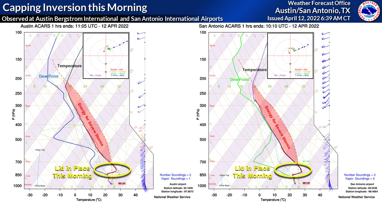
Monster cap on the 12z FWD sounding. Probably a repeat of yesterday, a few attempts but no rain for most.
The ensembles do look wetter in the long range but if trends hold true we will probably see that dry up.
The ensembles do look wetter in the long range but if trends hold true we will probably see that dry up.
0 likes
Winter time post are almost exclusively focused on the DFW area.
-
HockeyTx82
- S2K Supporter
- Posts: 2791
- Joined: Tue Oct 27, 2009 11:17 am
- Location: Ponder, TX
Re: Texas Spring 2022
bubba hotep wrote:Monster cap on the 12z FWD sounding. Probably a repeat of yesterday, a few attempts but no rain for most.
The ensembles do look wetter in the long range but if trends hold true we will probably see that dry up.
How does it compare to yesterday? What about the disturbance coming out of Mexico. Will that be able to break it?
0 likes
Don't hold me accountable for anything I post on this forum. Leave the real forecasting up to the professionals.
Location: Ponder, TX (all observation posts are this location unless otherwise noted)
Location: Ponder, TX (all observation posts are this location unless otherwise noted)
-
mcallum177
- Tropical Depression

- Posts: 98
- Joined: Sun Jun 14, 2009 12:39 am
- Location: Dallas, TX
Re: Texas Spring 2022
When they say lift and forcing are you guys referring to red areas of vorticity on 500mb? Or close ripples in the pressure lines at 500mb? I'm confused how to see lift on the different model layers
Ntxw wrote:Really unstable environment but no forcing to really get going. Some of the best fuel was over the metroplex.
https://i.imgur.com/KW73l1t.png
0 likes
-
Edwards Limestone

- S2K Supporter
- Posts: 510
- Age: 36
- Joined: Tue Dec 28, 2021 11:05 am
- Location: Smithson Valley, TX
Re: Texas Spring 2022
bubba hotep wrote:Monster cap on the 12z FWD sounding. Probably a repeat of yesterday, a few attempts but no rain for most.
The ensembles do look wetter in the long range but if trends hold true we will probably see that dry up.
Strong cap further south as well at AUS/SAT. Heavy cloud cover/drizzle down here this AM.
0 likes
The above post is NOT an official forecast and should not be used as such. It is just the opinion of the poster and may or may not be backed by sound meteorological data. It is NOT endorsed by any professional institution including Storm2k. For official information, please refer to NWS products.
-
rwfromkansas
- Category 5
- Posts: 3032
- Joined: Sat Aug 27, 2005 12:47 am
- Location: North Fort Worth
Re: Texas Spring 2022
The FWD graphic seems to be higher confidence than before and further west, so I am surprised to see the cap so strong. The cap is partly why I hate being this far south though I like Texas overall. It was usually much easier to break in KS.
0 likes
-
cheezyWXguy
- Category 5
- Posts: 6282
- Joined: Mon Feb 13, 2006 12:29 am
- Location: Dallas, TX
Re: Texas Spring 2022
rwfromkansas wrote:The FWD graphic seems to be higher confidence than before and further west, so I am surprised to see the cap so strong. The cap is partly why I hate being this far south though I like Texas overall. It was usually much easier to break in KS.
Hrrr yesterday held strong showing no initiation, even when other models like the nam started to cave. Showing storms today, with the cap weakening pretty significantly during the afternoon. I don’t think surface temps and instability will break the cap alone, but it looks like the forcing present today that wasn’t yesterday should make up the difference enough to fire a few storms off.
0 likes

Re: Texas Spring 2022

Forecast sounding from the 12Z NAM for 4PM this afternoon at KFWD, steep lapse rates, CAPE above 3K, if the cap doesn't hold today, there's likely going to be some severe thunderstorms in North Texas.
0 likes
The above post and any post by dhweather is NOT an official forecast and should not be used as such. It is just the opinion of the poster and may or may not be backed by sound meteorological data. It is NOT endorsed by any professional institution including storm2k.org. For official information, please refer to NWS products.
Re: Texas Spring 2022

The 11Z HRRR is similar to the NAM, steep lapse rates, high CAPE, eroding cap.
0 likes
The above post and any post by dhweather is NOT an official forecast and should not be used as such. It is just the opinion of the poster and may or may not be backed by sound meteorological data. It is NOT endorsed by any professional institution including storm2k.org. For official information, please refer to NWS products.
Return to “USA & Caribbean Weather”
Who is online
Users browsing this forum: No registered users and 39 guests