Florida Weather
Moderator: S2k Moderators
Forum rules

The posts in this forum are NOT official forecast and should not be used as such. They are just the opinion of the poster and may or may not be backed by sound meteorological data. They are NOT endorsed by any professional institution or STORM2K.
-
otowntiger
- Category 5

- Posts: 1932
- Joined: Tue Aug 31, 2004 7:06 pm
Re: Florida Weather
I don't see much energy making it to central Florida, per usual for these systems. I could be wrong but I think the severe threat for this area may have been overplayed.
0 likes


-
northjaxpro

- S2K Supporter

- Posts: 8900
- Joined: Mon Sep 27, 2010 11:21 am
- Location: Jacksonville, FL
Re: Florida Weather
It looks like the worst of the weather will come through the Jacksonville area sometime from 4;00 p.m. to 8 p.m.
We will see record max temperatures in the mid 80s here later today, which is just added fuel to the fire for these severe thunderstorms later today. A record high of 84 degrees yesterday. was recorded at NWS office in Jax.
We will see record max temperatures in the mid 80s here later today, which is just added fuel to the fire for these severe thunderstorms later today. A record high of 84 degrees yesterday. was recorded at NWS office in Jax.
0 likes
NEVER, EVER SAY NEVER in the tropics and weather in general, and most importantly, with life itself!!
________________________________________________________________________________________
Fay 2008 Beryl 2012 Debby 2012 Colin 2016 Hermine 2016 Julia 2016 Matthew 2016 Irma 2017 Dorian 2019
________________________________________________________________________________________
Fay 2008 Beryl 2012 Debby 2012 Colin 2016 Hermine 2016 Julia 2016 Matthew 2016 Irma 2017 Dorian 2019
Re: Florida Weather
That morning convection over south GA could very lay down an outflow boundary near the JAX area that could serve as a focus for additional rotation later on....recall that in many high end outbreaks outflows from previous convection later serve as focal points. Very dangerous day underway.
0 likes
Re: Florida Weather
otowntiger wrote:I don't see much energy making it to central Florida, per usual for these systems. I could be wrong but I think the severe threat for this area may have been overplayed.
Just the 850mb winds scream straight line wind potential that exceeds SVR criteria...especially from the bay area up through the nature coast.
0 likes
Re: Florida Weather
Incredible!!!!!! Best of luck to northern FL and southern GA today, praying this does not come true.

1 likes
-
northjaxpro
- S2K Supporter
- Posts: 8900
- Joined: Mon Sep 27, 2010 11:21 am
- Location: Jacksonville, FL
Re: Florida Weather
NDG wrote:Incredible!!!!!! Best of luck to northern FL and southern GA today, praying this does not come true.

Unfortunately NDG it has already come to happen in the region. I'm sure you seen the damage in Adel, Georgia. Just unbelievable to see the utter devastation there. So yes pray for everyone in my region today because we're going to need all prayers to get through this terrible weather situation.
2 likes
NEVER, EVER SAY NEVER in the tropics and weather in general, and most importantly, with life itself!!
________________________________________________________________________________________
Fay 2008 Beryl 2012 Debby 2012 Colin 2016 Hermine 2016 Julia 2016 Matthew 2016 Irma 2017 Dorian 2019
________________________________________________________________________________________
Fay 2008 Beryl 2012 Debby 2012 Colin 2016 Hermine 2016 Julia 2016 Matthew 2016 Irma 2017 Dorian 2019
Re: Florida Weather
Latest HRRR model shows the line of intense wx to pass through the Orlando Metro area between 7 PM & 9 PM, looking at the low level jet guaranteed 60 mph wind gusts with the storms if not higher, without counting the threat for tornadoes, make sure to secure loose items in your yard.
0 likes


Re: Florida Weather
northjaxpro wrote:NDG wrote:Incredible!!!!!! Best of luck to northern FL and southern GA today, praying this does not come true.
Unfortunately NDG it has already come to happen in the region. I'm sure you seen the damage in Adel, Georgia. Just unbelievable to see the utter devastation there. So yes pray for everyone in my region today because we're going to need all prayers to get through this terrible weather situation.
Yes, prayers are needed. The damage in Adel is unbelievable. We don't usually see damage or a tornado on that scale around here that often. NWS Jax has said earlier today that the scale of this severe/tornado outbreak is comparable to the Superstorm of 93 and the tornado outbreak at the University of Alabama a few years back. Storms are already starting to form ahead of the squall line that is poised to hit us around 4-7pm.
0 likes
The posts or stuff said are NOT an official forecast. Please look to the NHC and NWS for official forecasts and products.
Floyd-1999, Frances-2004, Jeanne-2004, Fay-2008, Beryl-2012, Debby-2012, Colin-2016, Hermine-2016, Julia-2016, Matthew-2016, Irma-2017, Elsa-2021, Idalia-2023, Debby-2024, Helene-2024.
Go Gators! Go Jags!
Floyd-1999, Frances-2004, Jeanne-2004, Fay-2008, Beryl-2012, Debby-2012, Colin-2016, Hermine-2016, Julia-2016, Matthew-2016, Irma-2017, Elsa-2021, Idalia-2023, Debby-2024, Helene-2024.
Go Gators! Go Jags!
Re: Florida Weather
18z Tallahassee Sounding, incredible, look at the low level jet and winds at h50!!!
A little capping going on at h80 but I am sure that will go away with the line storms pushing eastward.

A little capping going on at h80 but I am sure that will go away with the line storms pushing eastward.
0 likes
-
northjaxpro
- S2K Supporter
- Posts: 8900
- Joined: Mon Sep 27, 2010 11:21 am
- Location: Jacksonville, FL
Re: Florida Weather
JaxGator wrote:northjaxpro wrote:NDG wrote:Incredible!!!!!! Best of luck to northern FL and southern GA today, praying this does not come true.
Unfortunately NDG it has already come to happen in the region. I'm sure you seen the damage in Adel, Georgia. Just unbelievable to see the utter devastation there. So yes pray for everyone in my region today because we're going to need all prayers to get through this terrible weather situation.
Yes, prayers are needed. The damage in Adel is unbelievable. We don't usually see damage or a tornado on that scale around here that often. NWS Jax has said earlier today that the scale of this severe/tornado outbreak is comparable to the Superstorm of 93 and the tornado outbreak at the University of Alabama a few years back. Storms are already starting to form ahead of the squall line that is poised to hit us around 4-7pm.
They must be on this forum seeing what I talked about earlier this morning (being in my best tounge-in-cheek about this) I already earlier stated the same thing that this event is about as bad as I have ever seen. The only thing that it compares to is the March 1993 Superstorm in terms of such a favorable dynamic set-up synoptically for the development of tornadoes.
0 likes
NEVER, EVER SAY NEVER in the tropics and weather in general, and most importantly, with life itself!!
________________________________________________________________________________________
Fay 2008 Beryl 2012 Debby 2012 Colin 2016 Hermine 2016 Julia 2016 Matthew 2016 Irma 2017 Dorian 2019
________________________________________________________________________________________
Fay 2008 Beryl 2012 Debby 2012 Colin 2016 Hermine 2016 Julia 2016 Matthew 2016 Irma 2017 Dorian 2019

Re: Florida Weather
NDG wrote:Latest HRRR model shows the line of intense wx to pass through the Orlando Metro area between 7 PM & 9 PM, looking at the low level jet guaranteed 60 mph wind gusts with the storms if not higher, without counting the threat for tornadoes, make sure to secure loose items in your yard.
There's no doubt that the NWS is convinced that this event is becoming increasingly threatening to all North to Northeast Florida, and was raised from "enhanced" to moderate for much of North/Central Florida (approx. from Tampa northeastward to approx. Cocoa Beach. Given that however, I'm a little perplexed that Tornado Watches and especially Severe Storm Watches have not been advertised thus far for these areas??
No doubt that surface pressures are dropping everywhere and here in the Orlando/Sanford area I'm definitely seeing increased winds and wind gusts (albeit minus any associated convection or showers thus far). It is still my own opinion that much of Central Florida/Orlando area will not see tornadic activity. I think that the advertised squall line will not be particularly solid with perhaps a few discreet cells containing straight line gusts of 50mph to 60mph. That alone certainly IS a significant risk in and of itself, however I will truly be very surprised to see any widespread wind damage as others are anticipating. The primary reasons for my thinking is related to my belief that surface convergence will be less a factor given the anticipated unidirectional SSW to SW surface flow between 8:00pm - 10:00pm, as well as the primary surface low already moving further away by this time. I believe that the squall line will essentially weaken as it moves out ahead and farther east of the 500mb vorticity. Unfortunately for those farther north near St. Augustine to Jax, and points west and north of them..... things may well get pretty nasty. There does appear to be an enhanced risk further south as well, and area's around Lake 'O and especially East and N.E. from there, appear to indicate that the pre-dawn hours might be a point where the surface flow might be backed a bit more SSE at a time when the 500mb vorticity will likely be dropping through as well.
No doubt this appears to be an event that the NWS is very concerned that most people here in Florida need heed, for quickly changing and potential severe weather risk. You guys up in N.E. Florida - keep your head on a swivel this afternoon and evening!
0 likes
Andy D
(For official information, please refer to the NHC and NWS products.)
(For official information, please refer to the NHC and NWS products.)
Re: Florida Weather
Something just occured to me, while I may see waning energy with the southern extension of the squall line as it moves onto the Florida West coast from Tampa northward, I would think that NWS offices given their projected concerns for straight line winds would consider the potential piling of water or pseudo coastal surge of at least a foot or two in advance of this line of storms and potentially strong southwesterly winds? (I haven't actually looked at any W. Florida forecast offices so disregard this thought if local flooding statements have already been issued.)
1 likes
Andy D
(For official information, please refer to the NHC and NWS products.)
(For official information, please refer to the NHC and NWS products.)
Re: Florida Weather
Tallahassee's pressure is now down to 993mb, look at the surface winds ahead of the squall line!
Conditions at: KTLH observed 22 January 2017 18:53 UTC
Temperature: 25.0°C (77°F)
Dewpoint: 21.1°C (70°F) [RH = 79%]
Pressure (altimeter): 29.34 inches Hg (993.6 mb)
[Sea-level pressure: 993.4 mb]
Winds: from the S (190 degrees) at 24 MPH (21 knots; 10.9 m/s)
gusting to 37 MPH (32 knots; 16.6 m/s)
Visibility: 10 or more miles (16+ km)
Ceiling: 2200 feet AGL
Clouds: broken clouds at 2200 feet AGL
broken clouds at 3100 feet AGL
overcast cloud deck at 4400 feet AGL
Present Weather:
SOME DATA ABOVE MAY BE INACCURATE!!!
"$" is an indication the sensor requires maintenance
0 likes
Re: Florida Weather
chaser1 wrote:NDG wrote:Latest HRRR model shows the line of intense wx to pass through the Orlando Metro area between 7 PM & 9 PM, looking at the low level jet guaranteed 60 mph wind gusts with the storms if not higher, without counting the threat for tornadoes, make sure to secure loose items in your yard.
There's no doubt that the NWS is convinced that this event is becoming increasingly threatening to all North to Northeast Florida, and was raised from "enhanced" to moderate for much of North/Central Florida (approx. from Tampa northeastward to approx. Cocoa Beach. Given that however, I'm a little perplexed that Tornado Watches and especially Severe Storm Watches have not been advertised thus far for these areas??
No doubt that surface pressures are dropping everywhere and here in the Orlando/Sanford area I'm definitely seeing increased winds and wind gusts (albeit minus any associated convection or showers thus far). It is still my own opinion that much of Central Florida/Orlando area will not see tornadic activity. I think that the advertised squall line will not be particularly solid with perhaps a few discreet cells containing straight line gusts of 50mph to 60mph. That alone certainly IS a significant risk in and of itself, however I will truly be very surprised to see any widespread wind damage as others are anticipating. The primary reasons for my thinking is related to my belief that surface convergence will be less a factor given the anticipated unidirectional SSW to SW surface flow between 8:00pm - 10:00pm, as well as the primary surface low already moving further away by this time. I believe that the squall line will essentially weaken as it moves out ahead and farther east of the 500mb vorticity. Unfortunately for those farther north near St. Augustine to Jax, and points west and north of them..... things may well get pretty nasty. There does appear to be an enhanced risk further south as well, and area's around Lake 'O and especially East and N.E. from there, appear to indicate that the pre-dawn hours might be a point where the surface flow might be backed a bit more SSE at a time when the 500mb vorticity will likely be dropping through as well.
No doubt this appears to be an event that the NWS is very concerned that most people here in Florida need heed, for quickly changing and potential severe weather risk. You guys up in N.E. Florida - keep your head on a swivel this afternoon and evening!
it's too soon for watches for central florida yet. they will be forthcoming. if storm mode is broken as is advertised by most models some areas down here will thread the needle with nothing while others face some severe risk. we're gusting to nearly 50 mph in the bay area with sunny skies....it's not going to be tough to get 50kt (svr) gusts out of any thunderstorm downdraft.
0 likes
Re: Florida Weather
AT 203 PM EST/103 PM CST/...SEVERE THUNDERSTORMS CAPABLE OF
PRODUCING TORNADOES WERE LOCATED ALONG A LINE EXTENDING FROM 6 NM
SOUTH OF MEXICO BEACH TO 35 NM SOUTHWEST OF EMPIRE MICA WRECK...
MOVING NORTHEAST AT 90 KNOTS.
that's the special marin warning out of TLH. Has anyone seen a 90kt forward motion on storms before? I have not...not even close.
PRODUCING TORNADOES WERE LOCATED ALONG A LINE EXTENDING FROM 6 NM
SOUTH OF MEXICO BEACH TO 35 NM SOUTHWEST OF EMPIRE MICA WRECK...
MOVING NORTHEAST AT 90 KNOTS.
that's the special marin warning out of TLH. Has anyone seen a 90kt forward motion on storms before? I have not...not even close.
1 likes


Re: Florida Weather
The ingredients are in place for a historic severe weather day across most of Florida. According to my local Mets A High Risk potential has never occurred in Florida. Very unusual set-up goes without saying. F4 tornadoes are possible given this set-up. Pray we will not have any huge issues.
1 likes
-
otowntiger
- Category 5
- Posts: 1932
- Joined: Tue Aug 31, 2004 7:06 pm
Re: Florida Weather
0 likes
Re: Florida Weather
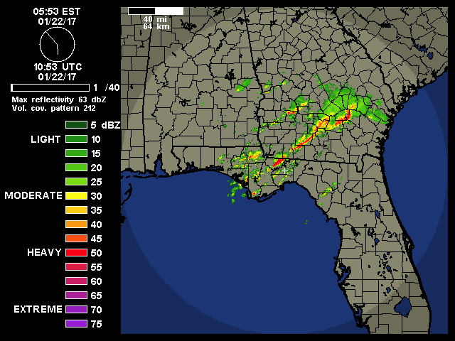
since the individual cells in the squall line are ripping northeast...the line must build southward for an attendant SVR risk over the moderate risk area around the bay area and it is doing just that over the last two hours or so. the forward motion is nuts... I would anticipate a new watch issued south of the existing watch area in the next hour or 2...we'll likely get a heads up mesoscale discussion from the SPC prior..
0 likes
Return to “USA & Caribbean Weather”
Who is online
Users browsing this forum: 869MB, Stratton23, txtwister78 and 21 guests