The timing of the system and its impacts to Halloween remains an
inordinate challenge. Although the initial convection is now within
48 hours, guidance cannot come to a reasonable consensus on its
evolution. The main takeaway from this morning`s data is that the
ECMWF`s trend to a slower and more southerly solution (now similar
to the CMC) is increasing the likelihood that Wednesday evening
activities will be adversely impacted. This also means that the
plodding frontal boundary will likely keep the warm sector within
our CWA, enhancing the potential for strong/severe storms.
Texas Fall 2018
Moderator: S2k Moderators
Forum rules

The posts in this forum are NOT official forecast and should not be used as such. They are just the opinion of the poster and may or may not be backed by sound meteorological data. They are NOT endorsed by any professional institution or STORM2K.
-
CaptinCrunch

- S2K Supporter

- Posts: 8779
- Age: 58
- Joined: Mon Nov 03, 2003 4:33 pm
- Location: Kennedale, TX (Tarrant Co.)
Re: Texas Fall 2018
Snipet from NWS FTW
0 likes
-
Haris

- Category 5

- Posts: 1814
- Joined: Mon Nov 27, 2017 8:19 pm
- Location: ( Bee Cave) West Austin, Texas
Re: Texas Fall 2018
Wow the euro ensembles are trending much wetter for CTX.
1” for Austin Wednesday!
1” for Austin Wednesday!
Last edited by Haris on Mon Oct 29, 2018 5:23 pm, edited 1 time in total.
1 likes
Weather geek and a storm spotter in West Austin. Not a degreed meteorologist. Big snow fan. Love rain and cold! Despise heat!

Re: Texas Fall 2018
I love my rain but let's try to keep the time for tricks and treats rain free in Austin. I always set up a large Halloween display in the front yard. Last year's display was diminished due to the rain that we had. I quite enjoyed the weather but it doesn't seem to entice families to venture out into the neighborhood for candy. Ended up with way too much left over.
2 likes
Resident Rain Miser
I am a weather hobbyist living 3.5 miles south of Downtown Austin and in no way or fashion should anything I say concerning forecasts be taken seriously. Please check your local NWS for accurate weather forecasting and conditions.
I am a weather hobbyist living 3.5 miles south of Downtown Austin and in no way or fashion should anything I say concerning forecasts be taken seriously. Please check your local NWS for accurate weather forecasting and conditions.
-
Portastorm

- Storm2k Moderator

- Posts: 9955
- Age: 63
- Joined: Fri Jul 11, 2003 9:16 am
- Location: Round Rock, TX
- Contact:
Re: Texas Fall 2018
JDawg512 wrote:I love my rain but let's try to keep the time for tricks and treats rain free in Austin. I always set up a large Halloween display in the front yard. Last year's display was diminished due to the rain that we had. I quite enjoyed the weather but it doesn't seem to entice families to venture out into the neighborhood for candy. Ended up with way too much left over.
Dunno JDawg, we could have another washout this year. As I told Haris earlier today, I still would wait until tomorrow afternoon and what the short range, higher res models show before getting too bummed out. But that being said both the Tech WRF and NAM-WRF have rain/storms in the Austin area during the afternoon and early evening.
Mrs. Portastorm wasn't happy with the candy I got at the store the other day, so I'm supposed to go tonight and trade it out for "the good stuff." But I don't want to end up with too much of the "good stuff" either!
7 likes
Any forecasts under my name are to be taken with a grain of salt. Get your best forecasts from the National Weather Service and National Hurricane Center.
-
Haris
- Category 5
- Posts: 1814
- Joined: Mon Nov 27, 2017 8:19 pm
- Location: ( Bee Cave) West Austin, Texas
Re: Texas Fall 2018
NWS FWD : Interesting snippet from AFD:
There are already notable differences in how guidance is handling
the pertinent upper-air features entering the Pacific Northwest at
this hour. Both the ECMWF and UKMET analyzed a somewhat deeper
PV-anomaly just pushing ashore this afternoon compared to the NAM
and GFS. The result is a more aggressively-digging shortwave
which eventually carves out a notably deeper trough on Wednesday
and Thursday across the Central US. Based on the notable darkening
on low- and mid-level moisture channel imagery across northern
California, this idea of a more vigorous shortwave may be more
realistic. Given this and the ECMWF`s better run-to-run
consistency of late, we`ve once again sided with its more
aggressive solution, which results in high PoPs pretty much area-
wide Wednesday morning and through the day as substantial ascent
overspreads the region.
2 likes
Weather geek and a storm spotter in West Austin. Not a degreed meteorologist. Big snow fan. Love rain and cold! Despise heat!
-
Brent
- S2K Supporter
- Posts: 38741
- Age: 37
- Joined: Sun May 16, 2004 10:30 pm
- Location: Tulsa Oklahoma
- Contact:
Re: Texas Fall 2018
Haris wrote:[url]https://preview.ibb.co/dUVS3A/35-E4-A995-5-C6-D-45-E5-A5-E0-FB669459-AC9-D.png [/url]
WOW
If only it were winter

One thing for sure November gonna begin way different than last year's all time record highs
1 likes
#neversummer
-
weatherdude1108
- Category 5
- Posts: 4228
- Joined: Tue Dec 13, 2011 1:04 pm
- Location: Northwest Austin/Cedar Park, TX
Re: Texas Fall 2018
Portastorm wrote:JDawg512 wrote:I love my rain but let's try to keep the time for tricks and treats rain free in Austin. I always set up a large Halloween display in the front yard. Last year's display was diminished due to the rain that we had. I quite enjoyed the weather but it doesn't seem to entice families to venture out into the neighborhood for candy. Ended up with way too much left over.
Dunno JDawg, we could have another washout this year. As I told Haris earlier today, I still would wait until tomorrow afternoon and what the short range, higher res models show before getting too bummed out. But that being said both the Tech WRF and NAM-WRF have rain/storms in the Austin area during the afternoon and early evening.
Mrs. Portastorm wasn't happy with the candy I got at the store the other day, so I'm supposed to go tonight and trade it out for "the good stuff." But I don't want to end up with too much of the "good stuff" either!
Yeah, Mrs. Weatherdude and I are eyeballing the weather for Wednesday for our 6-year old.
We did a couple trunk or treats yesterday around our area of town at churches through an online search. Mrs. Weatherdude's school where she teaches is doing a trunk or treat tomorrow.
So we may not need to do any trick or treating Wednesday!
5 likes
The preceding post is NOT an official forecast, and should not be used as such. It is only the opinion of the poster and may or may not be backed by sound meteorological data. It is NOT endorsed by any professional institution including storm2k.org. For Official Information please refer to the NHC and NWS products.
-
SnowintheFalls

- S2K Supporter
- Posts: 283
- Age: 48
- Joined: Fri Nov 22, 2013 5:06 pm
- Location: Burkburnett, TX
Re: Texas Fall 2018
Does anybody remember what year it snowed on Halloween in NTX? It was early 90's I believe. I know I am going to have some disappointed kiddos if trick or treating gets rained out!
1 likes
There is no day like a snow day!
-
Brent
- S2K Supporter
- Posts: 38741
- Age: 37
- Joined: Sun May 16, 2004 10:30 pm
- Location: Tulsa Oklahoma
- Contact:
Re: Texas Fall 2018
SnowintheFalls wrote:Does anybody remember what year it snowed on Halloween in NTX? It was early 90's I believe. I know I am going to have some disappointed kiddos if trick or treating gets rained out!
1991 or 1993 likely, both had snow near Halloween(1993 is the earliest snow in Dallas history on October 29, 1991 was just a cold rain in the metro it seems)
1981 is the wettest with over 3 inches of rain
0 likes
#neversummer
-
Yukon Cornelius
- S2K Supporter
- Posts: 1842
- Age: 42
- Joined: Thu Dec 20, 2012 9:23 pm
- Location: Dean, TX/Westcliffe, CO
Re: Texas Fall 2018
SnowintheFalls wrote:Does anybody remember what year it snowed on Halloween in NTX? It was early 90's I believe. I know I am going to have some disappointed kiddos if trick or treating gets rained out!
Yep, I remember it. We trick or treated in coats and gloves. If I remember right it started as sleet and turned over to snow shortly after.
1 likes
#neversummer
-
bubba hotep

- S2K Supporter
- Posts: 6014
- Joined: Wed Dec 28, 2016 1:00 am
- Location: Collin County Texas
Re: Texas Fall 2018
A blend of the 00z Euro and 06z GFS would be 2-3" area wide for DFW. The front should be far enough SE to limit svr wx across DFW but elevated storms will linger behind the front until the trough finally kicks through.
Solid graphic from NWS Houston

Solid graphic from NWS Houston
0 likes
Winter time post are almost exclusively focused on the DFW area.
-
Ralph's Weather
- S2K Supporter
- Posts: 3371
- Age: 38
- Joined: Fri Dec 13, 2013 11:55 am
- Location: Lindale, TX
- Contact:
Re: Texas Fall 2018
If it was not for the SW US ridge Thu Fri would be interesting, but as it is it looks cool with clearing skies maybe a bit dreary at least to start Thu.
0 likes
Follow on Facebook at Ralph's Weather.

Re: Texas Fall 2018
Chilly, wet Halloween day still according to short range guidance, the high will be sometime after midnight tonight.
DFW will cross 50" for the year. Kind of crazy we are experiencing Spring of 1957 in the Fall.
DFW will cross 50" for the year. Kind of crazy we are experiencing Spring of 1957 in the Fall.
1 likes
The above post and any post by Ntxw is NOT an official forecast and should not be used as such. It is just the opinion of the poster and may or may not be backed by sound meteorological data. It is NOT endorsed by any professional institution including Storm2k. For official information, please refer to NWS products.
Help support Storm2K!
-
CaptinCrunch
- S2K Supporter
- Posts: 8779
- Age: 58
- Joined: Mon Nov 03, 2003 4:33 pm
- Location: Kennedale, TX (Tarrant Co.)
Re: Texas Fall 2018
Ntxw wrote:Chilly, wet Halloween day still according to short range guidance, the high will be sometime after midnight tonight.
DFW will cross 50" for the year. Kind of crazy we are experiencing Spring of 1957 in the Fall.
The high will happen sometime before 1am if not 12:01am if the front is faster than current models perdicting. With the cloud cover and rain upper 50's for most of the day falling to the lower 50's after sunset feeling like upper 40's with the NW winds.
2 likes

Re: Texas Fall 2018
Looking like the heaviest rains will be just east/south of the metroplex. Most in the Metroplex should see 1-2" - 12Z GFS 48 hour total precip:

0 likes
The above post and any post by dhweather is NOT an official forecast and should not be used as such. It is just the opinion of the poster and may or may not be backed by sound meteorological data. It is NOT endorsed by any professional institution including storm2k.org. For official information, please refer to NWS products.
-
CaptinCrunch
- S2K Supporter
- Posts: 8779
- Age: 58
- Joined: Mon Nov 03, 2003 4:33 pm
- Location: Kennedale, TX (Tarrant Co.)
Re: Texas Fall 2018
Halloween 2018 will be an active one for North and Central Texas
as a deep upper trough moves east from the Four Corners and a cold
front moves south across the CWA. Numerous showers and
thunderstorms are expected to develop near and behind the cold
front with a potential for strong to severe storms. The most
likely area for severe weather will be just ahead of the cold
front across the south/southeast zones Wednesday afternoon.
Damaging winds and hail will be the primary hazards, however,
there will be enough low level shear for supercell formation in
the warm sector. The biggest unknown is just where the warm sector
will be during the heat of the day. The best estimate based on
high res CAMs is south of a line from Canton to Waco to Lampasas.
This area will have a brief window with all modes of severe
weather, including isolated tornadoes. It does appear that the
front will move through the entire region just after sunset
Wednesday, but the potential for showers/thunderstorms will
continue until the upper trough axis finally moves east during
the day Thursday. Although widespread heavy rainfall is not
expected, there will be a good chance for localized flooding since
many areas remain near saturation.
This may be a Halloween we remember as the potential for severe weather in SE TX may increase throughout the day tomorrow.
1 likes
-
Ralph's Weather
- S2K Supporter
- Posts: 3371
- Age: 38
- Joined: Fri Dec 13, 2013 11:55 am
- Location: Lindale, TX
- Contact:
Re: Texas Fall 2018
dhweather wrote:Looking like the heaviest rains will be just east/south of the metroplex. Most in the Metroplex should see 1-2" - 12Z GFS 48 hour total precip:
http://i64.tinypic.com/20aevjd.png
Euro is a bit more widespread with the 2"+ amounts extending from DFW down to Houston. Most models are more like an inch for DFW and keep the 3" stuff in E and SE TX.
0 likes
Follow on Facebook at Ralph's Weather.
-
wxman22

- Category 5
- Posts: 1923
- Joined: Mon Jan 30, 2006 12:39 am
- Location: Wichita Falls, TX
- Contact:
Re: Texas Fall 2018
There could be a severe weather outbreak tomorrow for portions of East/Southeast Texas and Louisiana.
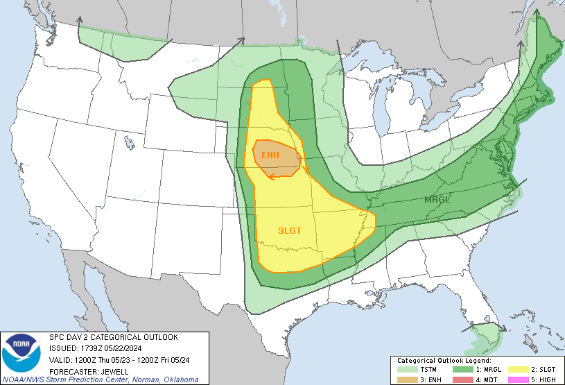
Day 2 Convective Outlook
NWS Storm Prediction Center Norman OK
1226 PM CDT Tue Oct 30 2018
Valid 311200Z - 011200Z
...THERE IS AN ENHANCED RISK OF SEVERE THUNDERSTORMS FROM SOUTHEAST
TEXAS TO THE LOWER MS VALLEY...
...SUMMARY...
Severe thunderstorms, primarily capable of damaging winds and a few
tornadoes, will be possible from southeast Texas to the lower
Mississippi Valley Wednesday evening into the overnight. Elsewhere,
a few severe storms capable of large hail will be possible near the
Edwards Plateau Wednesday afternoon/evening.
...Texas to the Lower Mississippi Valley...
The large-scale pattern will continue to amplify on Wednesday in
response to the interaction of a sharp shortwave trough moving into
west Texas and a secondary mid-level impulse dropping southeast
across the Rockies. As this occurs, southwesterly 500mb flow will
increase from east Texas to Mississippi through the overnight. A
low-level jet will correspondingly intensify from the upper Texas
coast to the Ohio Valley, with a corridor of at least 50-60 kt
south/southwesterly winds at 850 mb. Along the western edge of a
surface ridge centered over the southeast US coast, increasing
boundary-layer moisture will stream northward across the western
Gulf, southern Plains, and Mississippi Valley.
Convection will likely be ongoing across parts of central/northern
Texas Wednesday morning, generally located near/north of an
effective cold front stretching from the Big Country northeastward
to the Arklatex. These cells may be capable of isolated marginally
severe hail, but should mostly be sub-severe. Through the afternoon,
the effective front is forecast to drive southward across central
Texas. While the pre-frontal environment in this area will be
conditionally favorable for all severe hazards, deep-layer shear
vectors suggest most cells will be undercut by the front, limiting
the wind/tornado potential. Therefore, the Enhanced risk has been
contracted some here. Conversely, the Slight risk has been expanded
westward towards the Edwards Plateau, where the primary shortwave
trough and strong effective shear may encourage a few elevated
storms capable of large hail during the afternoon and evening.
The highest potential for impactful severe weather will likely exist
from southeast Texas towards the lower Mississippi Valley during the
evening and overnight. In conjunction with the aforementioned
low-level jet, channels of warm/moist low-level confluence streaming
north off the Gulf will probably encourage discrete development
ahead of a southwest/northeast-oriented line of strong/severe storms
moving east across the Sabine Valley during the evening. Forecast
soundings indicate ample low-level shear for stronger circulations
within both discrete/line-embedded supercells and QLCS structures,
with this potential likely maximized across portions of
western/central Louisiana and western Mississippi. Although
instability will be modest, enough low-level CAPE should be
available for a threat of tornadoes (a couple of which could be
strong) and damaging winds, especially considering surface dew
points in the upper 60s/lower 70s. Indeed, HREF guidance indicates
high probabilities of at least 500 J/kg of surface-based CAPE
extending to the Mississippi Delta. Considering this fairly
consistent signal from large-scale and hi-res guidance, the
Enhanced/Slight risks have been expanded eastward for a nocturnal
threat of tornadoes and damaging winds.
1 likes

Re: Texas Fall 2018
Possibility of a bow echo forming tomorrow evening for SETX. Probably will be a big wind threat more than anything else.
2 likes
Re: Texas Fall 2018
It’s kinda looking like there could be another severe weather outbreak next week as well.
0 likes
Return to “USA & Caribbean Weather”
Who is online
Users browsing this forum: No registered users and 28 guests