Texas Summer 2022

U.S. & Caribbean Weather Discussions and Severe Weather Events

Moderator: S2k Moderators

Forum rules

The posts in this forum are NOT official forecast and should not be used as such. They are just the opinion of the poster and may or may not be backed by sound meteorological data. They are NOT endorsed by any professional institution or STORM2K.

Help Support Storm2K
Message
Author
User avatar
Clearcloudz
Category 2
Category 2
Posts: 540
Joined: Sun Jun 10, 2018 1:46 pm
Location: Rosenberg TX

Re: Texas Summer 2022

#1141 Postby Clearcloudz » Sat Aug 20, 2022 7:26 am

SoupBone wrote:
jasons2k wrote:
Cpv17 wrote:
Yeah, no doubt lol that needs to expand southwest by quite a bit


Yes, please. I keep missing most of the rain.


Which is crazy. You're maybe 10 miles from me and I got dumped on. It was one cell that just sat on top of me.


00Z EURO rainfall totals, the trend is continuing to push towards Louisiana.

Image
2 likes   

User avatar
bubba hotep
S2K Supporter
S2K Supporter
Posts: 5837
Joined: Wed Dec 28, 2016 1:00 am
Location: Collin County Texas

Re: Texas Summer 2022

#1142 Postby bubba hotep » Sat Aug 20, 2022 7:33 am

Clearcloudz wrote:
SoupBone wrote:
jasons2k wrote:
Yes, please. I keep missing most of the rain.


Which is crazy. You're maybe 10 miles from me and I got dumped on. It was one cell that just sat on top of me.


00Z EURO rainfall totals, the trend is continuing to push towards Louisiana.

https://i.imgur.com/dMk3BK6.png


Not too worried about that. The Euro precipitation output has been bad the past couple of years. Of course, it will be right this time lol
2 likes   
Winter time post are almost exclusively focused on the DFW area.

User avatar
Clearcloudz
Category 2
Category 2
Posts: 540
Joined: Sun Jun 10, 2018 1:46 pm
Location: Rosenberg TX

Re: Texas Summer 2022

#1143 Postby Clearcloudz » Sat Aug 20, 2022 8:23 am

bubba hotep wrote:
Clearcloudz wrote:
SoupBone wrote:

Which is crazy. You're maybe 10 miles from me and I got dumped on. It was one cell that just sat on top of me.


00Z EURO rainfall totals, the trend is continuing to push towards Louisiana.

https://i.imgur.com/dMk3BK6.png


Not too worried about that. The Euro precipitation output has been bad the past couple of years. Of course, it will be right this time lol


Both the 06Z ICON and 06Z NAM shifted the majority of the rain out of Texas. Not a good trend for Texas but let's wait and see what happens.
Image
Image
0 likes   

weatherdude1108
Category 5
Category 5
Posts: 4228
Joined: Tue Dec 13, 2011 1:04 pm
Location: Northwest Austin/Cedar Park, TX

Re: Texas Summer 2022

#1144 Postby weatherdude1108 » Sat Aug 20, 2022 9:05 am

Cpv17 wrote:I got 2.8” here and you can barely even tell it rained. There’s not any standing water anywhere.


I didn't have any standing water either in the usual standing water spots. The 1.5" soaked right in.
0 likes   
The preceding post is NOT an official forecast, and should not be used as such. It is only the opinion of the poster and may or may not be backed by sound meteorological data. It is NOT endorsed by any professional institution including storm2k.org. For Official Information please refer to the NHC and NWS products.

rwfromkansas
Category 5
Category 5
Posts: 2627
Joined: Sat Aug 27, 2005 12:47 am
Location: North Fort Worth

Re: Texas Summer 2022

#1145 Postby rwfromkansas » Sat Aug 20, 2022 9:28 am

Uh oh. Lucy getting the football? The Euro still was decent. Not the NAM or ICON.
0 likes   

User avatar
bubba hotep
S2K Supporter
S2K Supporter
Posts: 5837
Joined: Wed Dec 28, 2016 1:00 am
Location: Collin County Texas

Re: Texas Summer 2022

#1146 Postby bubba hotep » Sat Aug 20, 2022 9:33 am

Clearcloudz wrote:
bubba hotep wrote:
Clearcloudz wrote:
00Z EURO rainfall totals, the trend is continuing to push towards Louisiana.

https://i.imgur.com/dMk3BK6.png


Not too worried about that. The Euro precipitation output has been bad the past couple of years. Of course, it will be right this time lol


Both the 06Z ICON and 06Z NAM shifted the majority of the rain out of Texas. Not a good trend for Texas but let's wait and see what happens.
https://i.imgur.com/y8poJ9P.png
https://i.imgur.com/NSdCX5i.png


On the flip side, the 12z HRRR and 3k NAM are south of those models.
2 likes   
Winter time post are almost exclusively focused on the DFW area.

lukem
Tropical Storm
Tropical Storm
Posts: 123
Joined: Wed Feb 17, 2010 2:53 pm

Re: Texas Summer 2022

#1147 Postby lukem » Sat Aug 20, 2022 9:55 am

bubba hotep wrote:
Clearcloudz wrote:
bubba hotep wrote:
Not too worried about that. The Euro precipitation output has been bad the past couple of years. Of course, it will be right this time lol


Both the 06Z ICON and 06Z NAM shifted the majority of the rain out of Texas. Not a good trend for Texas but let's wait and see what happens.
https://i.imgur.com/y8poJ9P.png
https://i.imgur.com/NSdCX5i.png


On the flip side, the 12z HRRR and 3k NAM are south of those models.

12z HRRR looks incredible for North Texas. Aren’t we getting in the range where you want to pay less attention to the long range models?
0 likes   

User avatar
Cpv17
Category 5
Category 5
Posts: 4975
Joined: Wed Dec 07, 2016 2:24 pm
Location: Wharton/El Campo, TX

Re: Texas Summer 2022

#1148 Postby Cpv17 » Sat Aug 20, 2022 10:42 am

The overnight trends look crappy for the southern half of the state.
0 likes   

User avatar
SoupBone
Category 5
Category 5
Posts: 3111
Joined: Tue Sep 20, 2005 5:24 pm

Re: Texas Summer 2022

#1149 Postby SoupBone » Sat Aug 20, 2022 10:51 am

Just had a random cell dump on top of me, around .25"
3 likes   
Personal Forecast Disclaimer:
The posts in this forum are NOT official forecast and should not be used as such. They are just the opinion of the poster and may or may not be backed by sound meteorological data. They are NOT endorsed by any professional institution or storm2k.org. For official information, please refer to the NHC and NWS products.

rwfromkansas
Category 5
Category 5
Posts: 2627
Joined: Sat Aug 27, 2005 12:47 am
Location: North Fort Worth

Re: Texas Summer 2022

#1150 Postby rwfromkansas » Sat Aug 20, 2022 12:19 pm

I would definitely pay more attention to the high-res models for tomorrow and Monday at least.

So, it's a good sign if the HRRR and 3K Nam are better.
3 likes   

Brent
S2K Supporter
S2K Supporter
Posts: 38088
Age: 36
Joined: Sun May 16, 2004 10:30 pm
Location: Tulsa Oklahoma
Contact:

Re: Texas Summer 2022

#1151 Postby Brent » Sat Aug 20, 2022 1:23 pm

Good luck y'all. Not looking so great up here but we did get a couple inches a couple weeks ago so it's not quite as dire up here. At least it'll keep temps down for a couple days if nothing else

I would agree on watching the hi res models though at this point
0 likes   
#neversummer

User avatar
South Texas Storms
Professional-Met
Professional-Met
Posts: 4224
Joined: Thu Jun 24, 2010 12:28 am
Location: Houston, TX

Re: Texas Summer 2022

#1152 Postby South Texas Storms » Sat Aug 20, 2022 2:08 pm

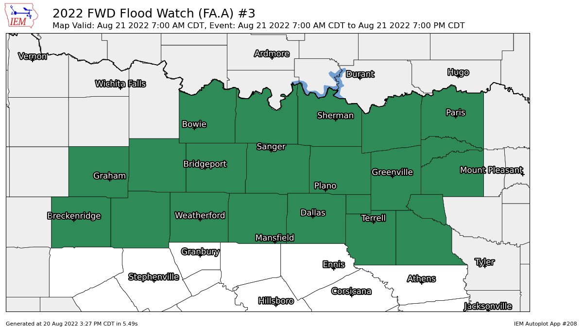
Welp, the trends sure aren't looking good for widespread heavy rainfall next week. As frustrating as this is, I think none of us should be surprised. I'm hoping most of us can get an inch or two, but the widespread 3+ inch totals are looking less likely with the system now forecast to track eastward into Louisiana instead of stalling across Texas for a few days.
2 likes   

Brent
S2K Supporter
S2K Supporter
Posts: 38088
Age: 36
Joined: Sun May 16, 2004 10:30 pm
Location: Tulsa Oklahoma
Contact:

Re: Texas Summer 2022

#1153 Postby Brent » Sat Aug 20, 2022 2:18 pm

South Texas Storms wrote:Welp, the trends sure aren't looking good for widespread heavy rainfall next week. As frustrating as this is, I think none of us should be surprised. I'm hoping most of us can get an inch or two, but the widespread 3+ inch totals are looking less likely with the system now forecast to track eastward into Louisiana instead of stalling across Texas for a few days.


Yeah that's another problem I see... The system is much more progressive. Literally my shot at rain up here is tonight and tomorrow and then it's gone. Not great. At one point it was gonna linger into Monday even Tuesday. It wouldn't surprise me if it barely rains at this point given the trends. Never wanna see progressive that means drier
2 likes   
#neversummer

User avatar
Haris
Category 5
Category 5
Posts: 1810
Joined: Mon Nov 27, 2017 8:19 pm
Location: ( Bee Cave) West Austin, Texas

Re: Texas Summer 2022

#1154 Postby Haris » Sat Aug 20, 2022 2:59 pm

It also looks like the track has shifted N between OKC and DFW.
0 likes   
Weather geek and a storm spotter in West Austin. Not a degreed meteorologist. Big snow fan. Love rain and cold! Despise heat!

User avatar
bubba hotep
S2K Supporter
S2K Supporter
Posts: 5837
Joined: Wed Dec 28, 2016 1:00 am
Location: Collin County Texas

Re: Texas Summer 2022

#1155 Postby bubba hotep » Sat Aug 20, 2022 3:46 pm

Image

Image

Image
0 likes   
Winter time post are almost exclusively focused on the DFW area.

User avatar
Ntxw
Storm2k Moderator
Storm2k Moderator
Posts: 22784
Joined: Wed Oct 21, 2009 6:34 pm
Location: DFW, Texas

Re: Texas Summer 2022

#1156 Postby Ntxw » Sat Aug 20, 2022 3:52 pm

I think it's becoming more evident the 20+ inch totals from the Euro was fantasy-ish. 3-5" still looks pretty good for the Red River valley and is more reality. There will be some who really cash in just depends where the boundaries set up and training. But hey a month ago this would have been a miracle.
2 likes   
The above post and any post by Ntxw is NOT an official forecast and should not be used as such. It is just the opinion of the poster and may or may not be backed by sound meteorological data. It is NOT endorsed by any professional institution including Storm2k. For official information, please refer to NWS products.

  Help support Storm2K!
Help Support Storm2K

rwfromkansas
Category 5
Category 5
Posts: 2627
Joined: Sat Aug 27, 2005 12:47 am
Location: North Fort Worth

Re: Texas Summer 2022

#1157 Postby rwfromkansas » Sat Aug 20, 2022 4:08 pm

Yeah, while I am sad to lose the more widespread 6+ all over central TX, it is still helpful to hopefully dent some drought and reset the pattern.
2 likes   

weatherdude1108
Category 5
Category 5
Posts: 4228
Joined: Tue Dec 13, 2011 1:04 pm
Location: Northwest Austin/Cedar Park, TX

Re: Texas Summer 2022

#1158 Postby weatherdude1108 » Sat Aug 20, 2022 4:50 pm

This is quite the write-up by EWX. :double: Drought to deluge. :firedevil: :firedevil: :rain: :rain: :rain:

LONG TERM...
(Monday through Saturday)
Issued at 206 PM CDT Sat Aug 20 2022

The long term forecast will likely result in the most active weather
pattern over South-Central Texas in quite some time.
Aloft, the
upper-level pattern will be far more conducive to disturbances
fueling showers and thunderstorms each day through the end of the
upcoming week. At the surface, moisture will continue to surge
northward out ahead of an approaching surface frontal boundary over
north Texas. This "cold" front will slowly sag southward on Monday,
reaching the Texas Hill Country and our northern tier of counties by
midday. Scattered showers and thunderstorms are expected to erupt
along this boundary as it slowly slides southward. In contrast to
recent rain events over the past week, the synoptic setup aloft is
certainly more supportive of widespread showers and storms, with
locally heavy rainfall becoming the greatest concern towards midweek.


As of this writing, area soil-moisture is almost non-existent,
despite some meaningful wetting rains Thursday-Friday over the Austin
metro and into portions of the Hill Country (Llano, Burnet, and
Gillespie Counties). This lack of soil moisture, in combination with
our ongoing Extreme (D3) to Exceptional (D4) drought conditions, any
rain that falls will certainly be beneficial. Something to note
however, with soils being as dry as they are, they may be more prone
to run-off moreso than usual, at least early in the week, before
soils can absorb more moisture. With the nature of our terrain over
the Hill Country and the inability of our clay-like soils to absorb
moisture quickly, flash flooding could be a bit more of a concern
than we would usually think. Add in the fact that some school
districts start this week, and additional traffic on area roads
should be taken into account.


Tuesday and Wednesday will be the main show, and based off of
deterministic and ensemble members of the GFS, ECMWF, and Canadian
model, the concerns are mounting for possible flooding. Pretty much
every ingredient is in place for Flash Flooding from an environmental
perspective given forecast model soundings: Long skinny CAPE profiles
with a very moist atmospheric profile throughout, well above average
PWATs some 1-3 SDs above the normal for late August, a deep warm-
cloud layer >10k ft, very slow LCL-EL (Cloud Layer) winds of <10 kts
for many locations, and relatively slow Corfidi upshear/downshear
vectors of 15-25 kts. This kind of setup can result in very heavy
rainfall rates, sometimes tropical in nature, and with a favorable
synoptic setup, a surface boundary to focus convection upon, and slow
storm motions, flash flooding is certainly a concern. As of this
afternoon, WPC has much of the region in the days 3, 4, and 5 slight
risk Excessive Rainfall Outlook. The possibility for an upgrade to
moderate for portions of the area on Monday, Tuesday, or Wednesday is
not out of the question. By the time all is said and done, we could
be looking at widespread totals of 3-5" with isolated pockets
greater than 6-8".


Despite all this, confidence in the higher end guidance is lower
than usual, and there is still considerable uncertainty in where the
heaviest rainfall will set up. The expectation for appreciable
rainfall over most of the area is quite high, with many seeing at
least 1-2", but whether a few locations pick up 6+ inches of rainfall
is highly dependent on the location of the frontal boundary and how
deep the trough digs into eastern Texas. Beyond Wednesday, expect our
unsettled pattern to continue. Daily chances for showers and
thunderstorms can be expected along with afternoon temperatures in
the mid to upper 80s and lower 90s.

https://forecast.weather.gov/product.ph ... glossary=1
2 likes   
The preceding post is NOT an official forecast, and should not be used as such. It is only the opinion of the poster and may or may not be backed by sound meteorological data. It is NOT endorsed by any professional institution including storm2k.org. For Official Information please refer to the NHC and NWS products.

User avatar
Iceresistance
Category 5
Category 5
Posts: 9288
Age: 21
Joined: Sat Oct 10, 2020 9:45 am
Location: Tecumseh, OK/Norman, OK

Re: Texas Summer 2022

#1159 Postby Iceresistance » Sat Aug 20, 2022 5:37 pm

There's a 10" marker SE of Texarkana, TX

Also, I may get an inch at best, but since most of Y'all are under Exceptional Drought in Northern Texas, they deserve the more rainfall than me. :)
0 likes   
Bill 2015 & Beta 2020

Winter 2020-2021 :cold:

All observations are in Tecumseh, OK unless otherwise noted.

Winter posts are focused mainly for Oklahoma & Texas.

Take any of my forecasts with a grain of salt, refer to the NWS, SPC, and NHC for official information

Never say Never with weather! Because ANYTHING is possible!

User avatar
Ntxw
Storm2k Moderator
Storm2k Moderator
Posts: 22784
Joined: Wed Oct 21, 2009 6:34 pm
Location: DFW, Texas

Re: Texas Summer 2022

#1160 Postby Ntxw » Sat Aug 20, 2022 5:39 pm

Iceresistance wrote:There's a 10" marker SE of Texarkana, TX

Also, I may get an inch at best, but since most of Y'all are under Exceptional Drought in Northern Texas, they deserve the more rainfall than me. :)


Hope you guys get some too. South of I-40 in Oklahoma is under extreme drought and probably only a month or so away from exceptional drought classification if enough rain doesn't fall.
0 likes   
The above post and any post by Ntxw is NOT an official forecast and should not be used as such. It is just the opinion of the poster and may or may not be backed by sound meteorological data. It is NOT endorsed by any professional institution including Storm2k. For official information, please refer to NWS products.


  Help support Storm2K!

Help Support Storm2K


Return to “USA & Caribbean Weather”

Who is online

Users browsing this forum: Brushcountry and 20 guests