Texas Fall 2018
Moderator: S2k Moderators
Forum rules

The posts in this forum are NOT official forecast and should not be used as such. They are just the opinion of the poster and may or may not be backed by sound meteorological data. They are NOT endorsed by any professional institution or STORM2K.
-
ThunderSleetDreams

- S2K Supporter

- Posts: 1510
- Age: 43
- Joined: Tue Dec 20, 2011 4:42 pm
- Location: S of Weimar, TX
Re: Texas Fall 2018
Oh November... Our late year severe weather season.
0 likes
#NeverSummer
I hibernate when it gets above 75 degrees!
I hibernate when it gets above 75 degrees!
-
weatherdude1108
- Category 5

- Posts: 4228
- Joined: Tue Dec 13, 2011 1:04 pm
- Location: Northwest Austin/Cedar Park, TX
Re: Texas Fall 2018
Just in time for trick or treating. 
Bob Rose:
Forecasters continuing to monitor forecasted weather developments for Wednesday and Wednesday night. A large trough of low pressure pushing east out of the Rockies tonight and Wednesday will push a strong Canadian cold front into the Texas Panhandle. The front is forecast to reach Northwest Texas Wednesday morning and the northern Hill Country around early to mid-afternoon. The front is predicted to reach the Austin area around 6-7 pm and the La Grange area about midnight. The front will continue moving south and push off the coast before sunrise Thursday morning.
A line of rain showers and thunderstorms is forecast to develop along and just behind the cold front Wednesday afternoon as it pushes south out of North Texas. The highest chance for thunderstorm development is expected to occur over areas that are along and to the east of Interstate 35. The line of rain and storms is forecast to move across the Austin/Central Texas area late Wednesday afternoon/early evening and continue moving southeast towards the coast Wednesday night. Wednesday's atmosphere will be structured in such a way that developing thunderstorms will have the potential to become strong to severe. The Storm Prediction Center has placed much of the Hill Country and the Austin area under a Slight Risk for severe thunderstorm. Areas east and southeast of Austin, including Bastrop, Lee, Fayette and Colorado Counties have been placed under an Enhanced Risk for severe thunderstorms Wednesday afternoon into Wednesday night. A slight risk means scattered severe storms will be possible while an enhance risk means numerous severe storms will be possible.
The primary severe weather threat is forecast to damaging straight line winds. However, there will also be a chance for large hail and a couple of isolated tornadoes. The severe weather threat will end once the line pushes south of the area.
Rain amounts through Wednesday night are expected to be a little heavier than previously forecast. Updated predictions now call for totals of 0.5 to 1 inch across much of the northern Hill Country, most of Central Texas along with the middle Texas coast.
Sunny, dry and cooler weather looks to follow Thursday through Saturday. High temperatures will be in the 60s Thursday, warming to around 70-72 degrees Friday and Saturday. Low temperatures Friday and Saturday mornings will generally be in the mid and upper 40s.
Wednesday's line of rain and thunderstorms may indeed interfere with Halloween Trick or Treat activities for folks across the Hill Country and in the Austin area. For those planning to be outside, remember to be weather aware not only for the rain, but also for the threat of severe storms and dangerous cloud to ground lightning. If you are close enough to hear thunder you are at risk from being struck by lightning.
Bob
https://www.lcra.org/water/river-and-we ... ather.aspx
0 likes
The preceding post is NOT an official forecast, and should not be used as such. It is only the opinion of the poster and may or may not be backed by sound meteorological data. It is NOT endorsed by any professional institution including storm2k.org. For Official Information please refer to the NHC and NWS products.


Re: Texas Fall 2018
As we await the active Halloween weather, it is time to look beyond.
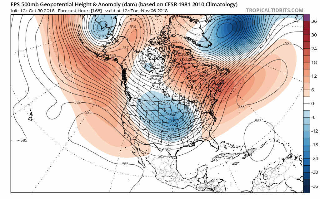
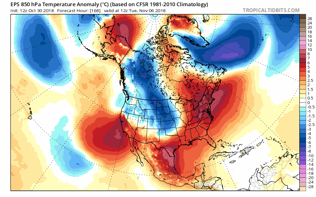
Yes! November is just about here as we march towards winter. The Euro ensembles and GFS ensembles show subtle hints of a colder regime setting foot soon to begin the new month! We are awaiting an early freeze and maybe mischief, who knows but be on the lookout for the OP models to show some impressive cold air (for the season). Signs of blocking showing up, or pseudo-blocking at least.
EPS
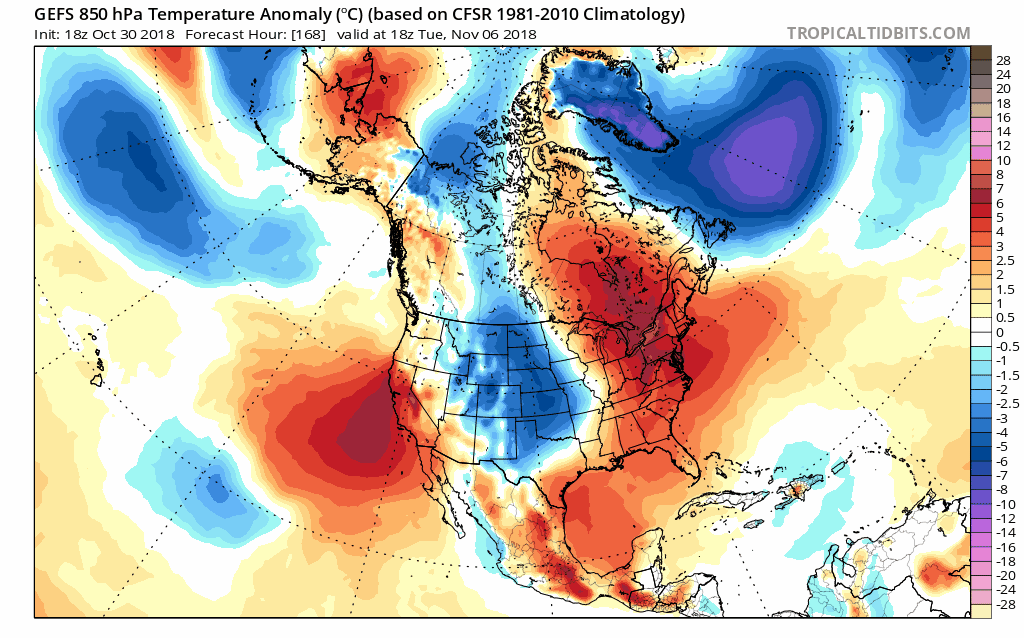
GEFS
It is my favorite time of year where you use the ensembles to help seek out cold blasts!
Yes! November is just about here as we march towards winter. The Euro ensembles and GFS ensembles show subtle hints of a colder regime setting foot soon to begin the new month! We are awaiting an early freeze and maybe mischief, who knows but be on the lookout for the OP models to show some impressive cold air (for the season). Signs of blocking showing up, or pseudo-blocking at least.
EPS
GEFS
It is my favorite time of year where you use the ensembles to help seek out cold blasts!
8 likes
The above post and any post by Ntxw is NOT an official forecast and should not be used as such. It is just the opinion of the poster and may or may not be backed by sound meteorological data. It is NOT endorsed by any professional institution including Storm2k. For official information, please refer to NWS products.
Help support Storm2K!
Re: Texas Fall 2018
Active subtropical jet. More inclined to believe the higher Euro totals.

4 likes
The above post and any post by Ntxw is NOT an official forecast and should not be used as such. It is just the opinion of the poster and may or may not be backed by sound meteorological data. It is NOT endorsed by any professional institution including Storm2k. For official information, please refer to NWS products.
Help support Storm2K!
Help support Storm2K!
-
wxman22

- Category 5
- Posts: 1923
- Joined: Mon Jan 30, 2006 12:39 am
- Location: Wichita Falls, TX
- Contact:
Re: Texas Fall 2018
The HRRR shows what looks to be decreet supercells tomorrow afternoon in southeast Texas

0 likes

Re: Texas Fall 2018
Talk about some wicked lightning that rolled through about 30 minutes ago!
0 likes
-
CaptinCrunch

- S2K Supporter
- Posts: 8779
- Age: 58
- Joined: Mon Nov 03, 2003 4:33 pm
- Location: Kennedale, TX (Tarrant Co.)
Re: Texas Fall 2018
Happy Halloween 

The high today Oct. 31 at DFW airport was 69 @ 12:53am, that start's the day off at 4 degrees below the normal high of 73.
Temperatures today will be dependent on whether you are ahead or
behind the cold front. Areas behind the cold front will remain in
the mid 50s to mid 60s. Those ahead of the front will climb into
the upper 70s. By tonight, lows will drop to the mid to upper 40s
across North Texas, and low 50s across Central Texas.
The high today Oct. 31 at DFW airport was 69 @ 12:53am, that start's the day off at 4 degrees below the normal high of 73.
2 likes
-
Tireman4

- S2K Supporter
- Posts: 5903
- Age: 60
- Joined: Fri Jun 30, 2006 1:08 pm
- Location: Humble, Texas
- Contact:
Re: Texas Fall 2018
CaptinCrunch wrote:Happy HalloweenTemperatures today will be dependent on whether you are ahead or
behind the cold front. Areas behind the cold front will remain in
the mid 50s to mid 60s. Those ahead of the front will climb into
the upper 70s. By tonight, lows will drop to the mid to upper 40s
across North Texas, and low 50s across Central Texas.
The high today Oct. 31 at DFW airport was 69 @ 12:53am, that start's the day off at 4 degrees below the normal high of 73.
Captin, did you release your annual Halloween Forecast already or did I miss it?
0 likes
-
CaptinCrunch
- S2K Supporter
- Posts: 8779
- Age: 58
- Joined: Mon Nov 03, 2003 4:33 pm
- Location: Kennedale, TX (Tarrant Co.)
Re: Texas Fall 2018
I haven't yet, I hope to have it ready this weekend. I was looking at analogs last night and I'm thinking of a blend or 09-10, and 76-77 as these two blend a solar minimul with a active southern jet. They both follow back/back La Ninas, they both had an active wet Sept and Oct, and they both continued to be average or above precip wise thru March the following year, both were colder than average...
AND....they both had muti snow/ice events!
even if we only get 1/4 the amount of rain we saw in Sept and Oct, in each of the next 3 months we would be average or above, so all we would need is the cold, and as I stated, both those Winters were colder than average.
AND....they both had muti snow/ice events!
even if we only get 1/4 the amount of rain we saw in Sept and Oct, in each of the next 3 months we would be average or above, so all we would need is the cold, and as I stated, both those Winters were colder than average.
5 likes
-
Ralph's Weather
- S2K Supporter
- Posts: 3371
- Age: 38
- Joined: Fri Dec 13, 2013 11:55 am
- Location: Lindale, TX
- Contact:
Re: Texas Fall 2018
CaptinCrunch wrote:I haven't yet, I hope to have it ready this weekend. I was looking at analogs last night and I'm thinking of a blend or 09-10, and 76-77 as these two blend a solar minimul with a active southern jet. They both follow back/back La Ninas, they both had an active wet Sept and Oct, and they both continued to be average or above precip wise thru March the following year, both were colder than average...
AND....they both had muti snow/ice events!
even if we only get 1/4 the amount of rain we saw in Sept and Oct, in each of the next 3 months we would be average or above, so all we would need is the cold, and as I stated, both those Winters were colder than average.
I agree with you, some of the winter forecasts I am seeing are banking on a weak STJ and I'm not seeing it. I'm not an ENSO guy so maybe this will morph into more of a Modoki El Nino and shut off the STJ, but for now the E Pac is plenty warm to continue to pump in moisture. The warm Gulf could fuel some strong late fall/early winter Gulf lows and strong storms like is happening today. I think Texas stays cool and wet through Dec at least and likely all winter.
3 likes
Follow on Facebook at Ralph's Weather.
-
bubba hotep

- S2K Supporter
- Posts: 6014
- Joined: Wed Dec 28, 2016 1:00 am
- Location: Collin County Texas
Re: Texas Fall 2018
Ralph's Weather wrote:CaptinCrunch wrote:I haven't yet, I hope to have it ready this weekend. I was looking at analogs last night and I'm thinking of a blend or 09-10, and 76-77 as these two blend a solar minimul with a active southern jet. They both follow back/back La Ninas, they both had an active wet Sept and Oct, and they both continued to be average or above precip wise thru March the following year, both were colder than average...
AND....they both had muti snow/ice events!
even if we only get 1/4 the amount of rain we saw in Sept and Oct, in each of the next 3 months we would be average or above, so all we would need is the cold, and as I stated, both those Winters were colder than average.
I agree with you, some of the winter forecasts I am seeing are banking on a weak STJ and I'm not seeing it. I'm not an ENSO guy so maybe this will morph into more of a Modoki El Nino and shut off the STJ, but for now the E Pac is plenty warm to continue to pump in moisture. The warm Gulf could fuel some strong late fall/early winter Gulf lows and strong storms like is happening today. I think Texas stays cool and wet through Dec at least and likely all winter.
I've done some tinkering and what I'm seeing is below normal temps and above normal precipitation for Nov. Then for DJF overall below normal temps and normal precipitation. December looks to have the best chances of being a bust month with warmer/drier risk. I need to go back through my analogs and see what influence the polar strat had on those years.
When you go back through individual nino yrs there are some ugly dry and warm winters. I think we can safely pull those years out now. Then look at recent history for Texas and one could probably argue that we should fade our analog results warmer and wetter. I see a much below normal DJF in the analog review so maybe we still end up below even with a fade warmer.
3 likes
Winter time post are almost exclusively focused on the DFW area.
-
Yukon Cornelius
- S2K Supporter
- Posts: 1842
- Age: 42
- Joined: Thu Dec 20, 2012 9:23 pm
- Location: Dean, TX/Westcliffe, CO
Re: Texas Fall 2018
It can stop raining now. For some reason I thought all of this stuff was suppose to be further south? It’s been pouring all day.
0 likes
#neversummer
-
CaptinCrunch
- S2K Supporter
- Posts: 8779
- Age: 58
- Joined: Mon Nov 03, 2003 4:33 pm
- Location: Kennedale, TX (Tarrant Co.)
Re: Texas Fall 2018
The bulk of the rain and colder air was definitely lagging behind the initial front by several hours. We had a few good down pours with thunder here in FTW about an hour ago.
Most of NTX is now in the mid to upper 50's with continued rain, some heavy at times with thunder.
Most of NTX is now in the mid to upper 50's with continued rain, some heavy at times with thunder.
Last edited by CaptinCrunch on Wed Oct 31, 2018 2:27 pm, edited 1 time in total.
0 likes
-
Brent
- S2K Supporter
- Posts: 38741
- Age: 37
- Joined: Sun May 16, 2004 10:30 pm
- Location: Tulsa Oklahoma
- Contact:
Re: Texas Fall 2018
how surprising, another overperforming rain event in N TX, definitely the trend of the fall
0 likes
#neversummer

Re: Texas Fall 2018
Is it just me or did the 12z Euro just drop the storm for the early part of next week?
0 likes
-
bubba hotep
- S2K Supporter
- Posts: 6014
- Joined: Wed Dec 28, 2016 1:00 am
- Location: Collin County Texas
Re: Texas Fall 2018
DFW has now moved past 50" of rain for the year before Nov 1st.
1 likes
Winter time post are almost exclusively focused on the DFW area.

Re: Texas Fall 2018
The radar is starting to light up down in this region. Will be closely monitoring the timing as the day goes on.
0 likes
Resident Rain Miser
I am a weather hobbyist living 3.5 miles south of Downtown Austin and in no way or fashion should anything I say concerning forecasts be taken seriously. Please check your local NWS for accurate weather forecasting and conditions.
I am a weather hobbyist living 3.5 miles south of Downtown Austin and in no way or fashion should anything I say concerning forecasts be taken seriously. Please check your local NWS for accurate weather forecasting and conditions.
Re: Texas Fall 2018
Nasty looking cell on the southwest side of Houston right now over the Sugar Land/Missouri City area. Starting to show some signs of rotation.
0 likes
-
bubba hotep
- S2K Supporter
- Posts: 6014
- Joined: Wed Dec 28, 2016 1:00 am
- Location: Collin County Texas
Re: Texas Fall 2018
Things are getting wild down in Houston!
1 likes
Winter time post are almost exclusively focused on the DFW area.
Return to “USA & Caribbean Weather”
Who is online
Users browsing this forum: Stratton23 and 59 guests