Page 60 of 69
Re: Texas Spring 2018
Posted: Fri May 18, 2018 5:24 pm
by Ntxw
bubba hotep wrote:Looks like DFW hit 95 today, earlier in the week 100 looked possible. Small victories, I guess.
The 95 is 1F shy of the daily record, 96F in 1956
Re: Texas Spring 2018
Posted: Fri May 18, 2018 6:00 pm
by Haris
GFS has a fairly soggy memorial day weekend!
Re: Texas Spring 2018
Posted: Fri May 18, 2018 9:30 pm
by bubba hotep
Ntxw wrote:bubba hotep wrote:Looks like DFW hit 95 today, earlier in the week 100 looked possible. Small victories, I guess.
The 95 is 1F shy of the daily record, 96F in 1956
I was thinking the record was a lock a just a couple of days ago but it was still too hot today for this early in the year!
Re: Texas Spring 2018
Posted: Fri May 18, 2018 9:38 pm
by Haris

LOCK IT IN FOR SUNDAY!!!
Re: Texas Spring 2018
Posted: Fri May 18, 2018 10:44 pm
by bubba hotep
Not horrible for DFW

Re: Texas Spring 2018
Posted: Sat May 19, 2018 8:09 am
by Ntxw
I hope I am wrong on this in every way. I'd love nothing more than a cool snap and rain. But the ENS shows the growing party of the 500mb Sonoran death ridge to end May/early June. We might see a stretch of very hot weather and the CPC has highlighted such a risk. It's too early for strings of 100s, but probably hotter than what we saw the past week. The next few days will probably be the best days we got for awhile.


Also as a friendly reminder the summer thread will open on June 1st marking the end of meteorological spring.
Re: Texas Spring 2018
Posted: Sat May 19, 2018 10:34 am
by gpsnowman
If May is any indication we are in serious weather caca. It was so hot yesterday I was sweating in my living room watching the Rangers. September is a long ways away. Sigh. Above average heat with drought slowly creeping in is not a good thing. Another thing, the ground is showing big cracks already and grass is browning like it is mid summer. In the middle of May which should be peak green season.
Re: Texas Spring 2018
Posted: Sat May 19, 2018 12:37 pm
by Haris
Re: Texas Spring 2018
Posted: Sat May 19, 2018 12:40 pm
by weatherdude1108
Haris wrote:
You beat me to it!

I was about to post that. Interesting how localized it is.
Re: Texas Spring 2018
Posted: Sat May 19, 2018 2:31 pm
by Ntxw
The Pacific ITCZ is lit up like a Christmas tree. Unfortunately we don't have a 500mb strong trof to our west/southwest to draw it up. Weakness is sitting over Florida and the southeast

Re: Texas Spring 2018
Posted: Sat May 19, 2018 4:47 pm
by Haris

GFS went from NO rain to now heavy rains Sunday! Dropping 1-2" just W of Austin
Re: Texas Spring 2018
Posted: Sat May 19, 2018 7:46 pm
by hriverajr
Getting a bit of rain in DRT...... been a while...
Re: Texas Spring 2018
Posted: Sat May 19, 2018 8:06 pm
by bubba hotep
Storms about to push into W Falls?

Re: Texas Spring 2018
Posted: Sat May 19, 2018 10:18 pm
by gpsnowman
Steve McCauley mentions an outflow boundary from the current storms near Wichita Falls could set us up for some storms tomorrow. Fingers crossed.
Re: Texas Spring 2018
Posted: Sun May 20, 2018 7:16 am
by Ntxw
Finally a decent complex coming through!

Re: Texas Spring 2018
Posted: Sun May 20, 2018 7:43 am
by weatherdude1108
Was out running this morning and got some occasional streamer showers.
After that, i was just now walking the dog, and it just came down hard! Pouring right now!
Both the dog and I raced back to the house. We are both SOAKED!
I love it! Not sure if dog loves it.lol
Re: Texas Spring 2018
Posted: Sun May 20, 2018 8:05 am
by bubba hotep
Last night the CAMs had options for today ranging from a decaying system moving in from the NW to storms firing later today along an outflow. I don't recall any showing a complex moving in from the SW lol

Re: Texas Spring 2018
Posted: Sun May 20, 2018 8:12 am
by DonWrk
Looks beautiful coming in! Hoping for a good soaking!
Re: Texas Spring 2018
Posted: Sun May 20, 2018 8:53 am
by Ntxw
Southern flank of this has slowed down some while the eastern flank is weakening. Usually a sign some training might occur over some areas as streamer storms are moving northward slowly with surging low level moisture.

Lighting up in Central Texas with a TOR warning west of Georgetown

Re: Texas Spring 2018
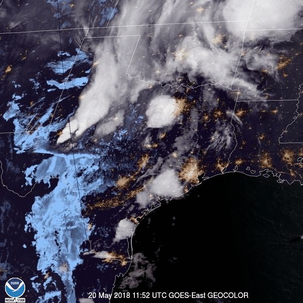
Posted: Sun May 20, 2018 9:03 am
by Ntxw
Goes East imagery of the southern plains this morning. Sorry to those with data limits!