Texas Spring 2023

U.S. & Caribbean Weather Discussions and Severe Weather Events

Moderator: S2k Moderators

Forum rules

The posts in this forum are NOT official forecast and should not be used as such. They are just the opinion of the poster and may or may not be backed by sound meteorological data. They are NOT endorsed by any professional institution or STORM2K.

Help Support Storm2K
Message
Author
User avatar
Ntxw
Storm2k Moderator
Storm2k Moderator
Posts: 22730
Joined: Wed Oct 21, 2009 6:34 pm
Location: DFW, Texas

Re: Texas Spring 2023

#1181 Postby Ntxw » Sat May 06, 2023 8:16 pm

rwfromkansas wrote:Lots of lightning in Tarrant well ahead of the actual storms.

What is this called?


Summer.
4 likes   
The above post and any post by Ntxw is NOT an official forecast and should not be used as such. It is just the opinion of the poster and may or may not be backed by sound meteorological data. It is NOT endorsed by any professional institution including Storm2k. For official information, please refer to NWS products.

  Help support Storm2K!
Help Support Storm2K

HockeyTx82
S2K Supporter
S2K Supporter
Posts: 2450
Joined: Tue Oct 27, 2009 11:17 am
Location: Ponder, TX

Re: Texas Spring 2023

#1182 Postby HockeyTx82 » Sat May 06, 2023 8:19 pm

rwfromkansas wrote:Lots of lightning in Tarrant well ahead of the actual storms.

What is this called?


I aksed Chat GPT on Bing

The meteorological term for lightning well ahead of a thunderstorm cluster is called "anvil crawler" or "anvil lightning" ¹. It is a type of lightning that moves horizontally across the sky and is often seen on the underside of the anvil cloud that spreads out from the top of a thunderstorm ².

Source: Conversation with Bing, 5/6/2023
(1) Glossary of Weather Terms - National Weather Service. https://www.weather.gov/otx/Glossary_of_Weather_Terms.
(2) Severe Weather 101: Thunderstorm Types - NOAA National Severe Storms .... https://www.nssl.noaa.gov/education/svr ... rms/types/.
(3) Severe Weather 101: Lightning Forecasting - NOAA National Severe Storms .... https://www.nssl.noaa.gov/education/svr ... recasting/.
2 likes   
Don't hold me accountable for anything I post on this forum. Leave the real forecasting up to the professionals.

Location: Ponder, TX (all observation posts are this location unless otherwise noted)

gpsnowman
S2K Supporter
S2K Supporter
Posts: 3157
Joined: Fri Jan 07, 2011 10:35 am
Location: Grand Prairie Tx

Re: Texas Spring 2023

#1183 Postby gpsnowman » Sat May 06, 2023 8:19 pm

Ntxw wrote:
rwfromkansas wrote:Lots of lightning in Tarrant well ahead of the actual storms.

What is this called?


Summer.

I have some "summer" activity in Las Colinas as well.
1 likes   

User avatar
bubba hotep
S2K Supporter
S2K Supporter
Posts: 5830
Joined: Wed Dec 28, 2016 1:00 am
Location: Collin County Texas

Re: Texas Spring 2023

#1184 Postby bubba hotep » Sat May 06, 2023 8:49 pm

0 likes   
Winter time post are almost exclusively focused on the DFW area.

dpep4
Tropical Storm
Tropical Storm
Posts: 198
Joined: Sat Sep 09, 2017 9:04 pm

Re: Texas Spring 2023

#1185 Postby dpep4 » Sat May 06, 2023 9:05 pm

That's a big ol' notch on that tor warn south of Brownwood.
0 likes   

rwfromkansas
Category 5
Category 5
Posts: 2532
Joined: Sat Aug 27, 2005 12:47 am
Location: North Fort Worth

Re: Texas Spring 2023

#1186 Postby rwfromkansas » Sat May 06, 2023 10:17 pm

Finally rain! Almost .50 so far.
4 likes   

User avatar
bubba hotep
S2K Supporter
S2K Supporter
Posts: 5830
Joined: Wed Dec 28, 2016 1:00 am
Location: Collin County Texas

Re: Texas Spring 2023

#1187 Postby bubba hotep » Sun May 07, 2023 9:11 am

That was a right and proper spring thunderstorm for MBY last night.
4 likes   
Winter time post are almost exclusively focused on the DFW area.

User avatar
Cpv17
Category 5
Category 5
Posts: 4915
Joined: Wed Dec 07, 2016 2:24 pm
Location: Wharton/El Campo, TX

Re: Texas Spring 2023

#1188 Postby Cpv17 » Sun May 07, 2023 3:39 pm

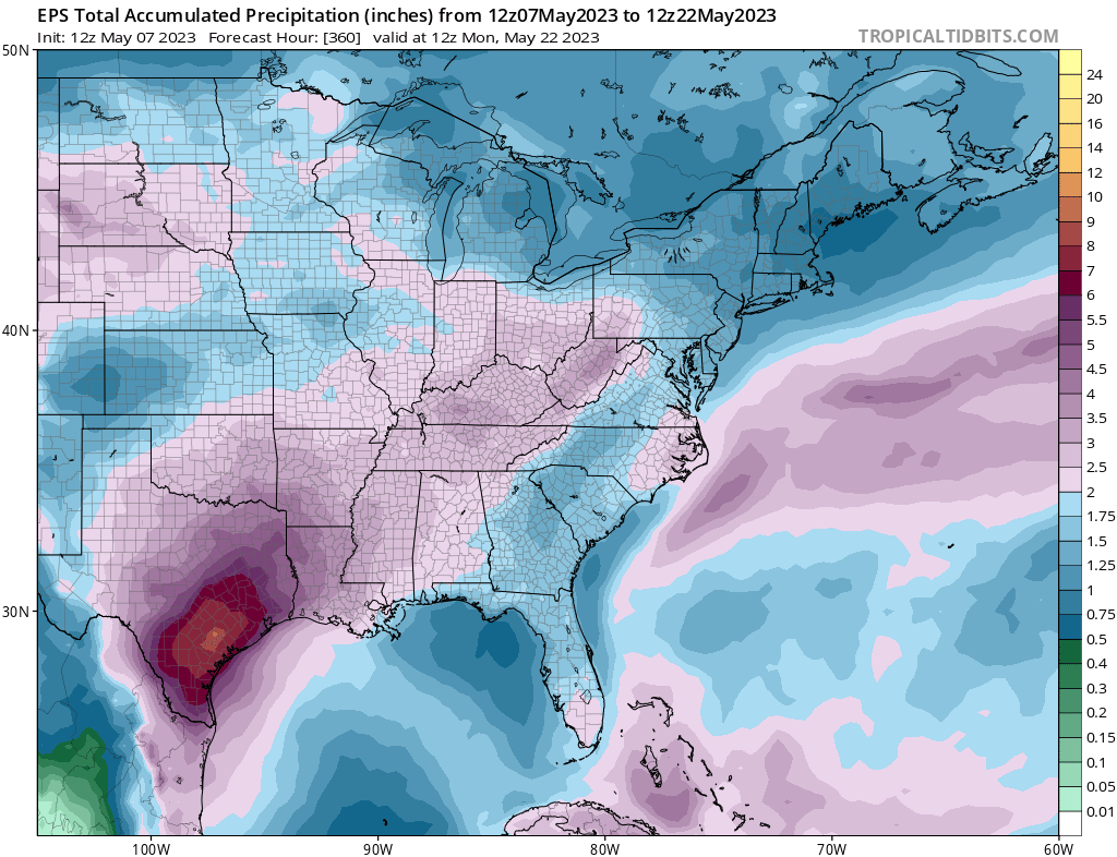
Well it looks like that drought near SA is about to go bye bye over the next week.
2 likes   

User avatar
Ntxw
Storm2k Moderator
Storm2k Moderator
Posts: 22730
Joined: Wed Oct 21, 2009 6:34 pm
Location: DFW, Texas

Re: Texas Spring 2023

#1189 Postby Ntxw » Sun May 07, 2023 3:44 pm

Some prominent rainfall wet years are popping up. 1957, 1973, and 2007 been in and out. 1957 was oncoming strong El Nino while the other two were backend of outgoing El Nino into La Nina. Lays groundwork for cool summer feedback.
2 likes   
The above post and any post by Ntxw is NOT an official forecast and should not be used as such. It is just the opinion of the poster and may or may not be backed by sound meteorological data. It is NOT endorsed by any professional institution including Storm2k. For official information, please refer to NWS products.


  Help support Storm2K!

Help Support Storm2K


User avatar
South Texas Storms
Professional-Met
Professional-Met
Posts: 4198
Joined: Thu Jun 24, 2010 12:28 am
Location: Houston, TX

Re: Texas Spring 2023

#1190 Postby South Texas Storms » Sun May 07, 2023 5:18 pm

Cpv17 wrote:Well it looks like that drought near SA is about to go bye bye over the next week.


I sure hope so!
0 likes   

User avatar
Cpv17
Category 5
Category 5
Posts: 4915
Joined: Wed Dec 07, 2016 2:24 pm
Location: Wharton/El Campo, TX

Re: Texas Spring 2023

#1191 Postby Cpv17 » Sun May 07, 2023 5:32 pm

South Texas Storms wrote:
Cpv17 wrote:Well it looks like that drought near SA is about to go bye bye over the next week.


I sure hope so!


Image
2 likes   

User avatar
bubba hotep
S2K Supporter
S2K Supporter
Posts: 5830
Joined: Wed Dec 28, 2016 1:00 am
Location: Collin County Texas

Re: Texas Spring 2023

#1192 Postby bubba hotep » Sun May 07, 2023 5:42 pm

Stroms off the dryline appear to be more robust than the 18z hi-res models were showing. Maybe we'll get a surprise MCS into DFW later tonight?
0 likes   
Winter time post are almost exclusively focused on the DFW area.

Bhow
Tropical Depression
Tropical Depression
Posts: 57
Joined: Wed Jul 06, 2016 11:52 am

Re: Texas Spring 2023

#1193 Postby Bhow » Sun May 07, 2023 6:33 pm

Feels like it’s been a long time seeing EPS mean of 6-7 inches down here in south central Texas
2 likes   

User avatar
bubba hotep
S2K Supporter
S2K Supporter
Posts: 5830
Joined: Wed Dec 28, 2016 1:00 am
Location: Collin County Texas

Re: Texas Spring 2023

#1194 Postby bubba hotep » Sun May 07, 2023 7:49 pm

Insane radar loop of the cell mergers over Knox County. It's been a wild evening out there with a nearly stationary supercell just barely drifting around after each new merger.

Image
0 likes   
Winter time post are almost exclusively focused on the DFW area.

User avatar
bubba hotep
S2K Supporter
S2K Supporter
Posts: 5830
Joined: Wed Dec 28, 2016 1:00 am
Location: Collin County Texas

Re: Texas Spring 2023

#1195 Postby bubba hotep » Sun May 07, 2023 7:55 pm

0 likes   
Winter time post are almost exclusively focused on the DFW area.

User avatar
Texas Snowman
Storm2k Moderator
Storm2k Moderator
Posts: 6151
Joined: Fri Jan 25, 2008 11:29 am
Location: Denison, Texas

Re: Texas Spring 2023

#1196 Postby Texas Snowman » Sun May 07, 2023 10:27 pm

Well hello again 2015, longtime since we’ve seen each other…

—————-
 https://twitter.com/austinburkeswx/status/1655294094933884934


1 likes   
The above post and any post by Texas Snowman is NOT an official forecast and should not be used as such. It is just the opinion of the poster and may or may not be backed by sound meteorological data. It is NOT endorsed by any professional institution including storm2k.org. For official information, please refer to NWS products.

User avatar
Texas Snowman
Storm2k Moderator
Storm2k Moderator
Posts: 6151
Joined: Fri Jan 25, 2008 11:29 am
Location: Denison, Texas

Re: Texas Spring 2023

#1197 Postby Texas Snowman » Sun May 07, 2023 10:30 pm

Flash Flood Statement
National Weather Service San Angelo TX
953 PM CDT Sun May 7 2023

TXC353-441-080445-
/O.CON.KSJT.FF.W.0007.000000T0000Z-230508T0445Z/
/00000.0.ER.000000T0000Z.000000T0000Z.000000T0000Z.OO/
Nolan TX-Taylor TX-
953 PM CDT Sun May 7 2023

...FLASH FLOOD WARNING REMAINS IN EFFECT UNTIL 1145 PM CDT THIS
EVENING FOR NORTHEASTERN NOLAN AND NORTHERN TAYLOR COUNTIES...

At 952 PM CDT, Doppler radar indicated thunderstorms producing heavy
rain near Tye and Goodfellow AFB area...moving east at 20 mph.
Between 3 and 5.5 inches of rain have fallen. The expected rainfall
rate is 2.5 inches in 1 hour. Additional rainfall amounts of 1 to 2
inches are possible in the warned area. Flash flooding is ongoing or
expected to begin shortly.

HAZARD...Life threatening flash flooding. Thunderstorms producing
flash flooding.

SOURCE...Radar.

IMPACT...Life threatening flash flooding of creeks and streams,
urban areas, highways, streets and underpasses.

Some locations that will experience flash flooding include...
Abilene, Merkel, Tye, Buffalo Gap, Trent, View, Dyess Afb, Caps
and Potosi.

This includes the following highways...
Interstate 20 between Mile Markers 256 and 280.

This includes the following Low Water Crossings...
Texas Avenue at Arnold Boulevard, Craig Street at Catclaw Creek,
County Road 387 crossing Little Bitter Creek, crossings along County
Road 335, crossings along County Road 357, crossings along County
Road 283, crossings along County Road 400, County Road 150 crossing
Cedar Creek, crossings along County Road 127 and crossings along
County Road 410.

PRECAUTIONARY/PREPAREDNESS ACTIONS...

Turn around, don't drown when encountering flooded roads. Most flood
deaths occur in vehicles.

Be especially cautious at night when it is harder to recognize the
dangers of flooding.
0 likes   
The above post and any post by Texas Snowman is NOT an official forecast and should not be used as such. It is just the opinion of the poster and may or may not be backed by sound meteorological data. It is NOT endorsed by any professional institution including storm2k.org. For official information, please refer to NWS products.

User avatar
Texas Snowman
Storm2k Moderator
Storm2k Moderator
Posts: 6151
Joined: Fri Jan 25, 2008 11:29 am
Location: Denison, Texas

Re: Texas Spring 2023

#1198 Postby Texas Snowman » Sun May 07, 2023 10:31 pm

Flash Flood Statement
National Weather Service Norman OK
924 PM CDT Sun May 7 2023

TXC275-080400-
/O.CON.KOUN.FF.W.0007.000000T0000Z-230508T0400Z/
/00000.0.ER.000000T0000Z.000000T0000Z.000000T0000Z.OO/
Knox TX-
924 PM CDT Sun May 7 2023

...FLASH FLOOD WARNING REMAINS IN EFFECT UNTIL 11 PM CDT THIS
EVENING FOR CENTRAL KNOX COUNTY...

At 924 PM CDT, local law enforcement reported flash flooding across
the warned area. Between 5 and 6 inches of rain have fallen. Flash
flooding is already occurring.

HAZARD...Flash flooding caused by heavy rain.

SOURCE...Law enforcement reported.

IMPACT...Flash flooding of small creeks and streams, urban areas,
highways, streets and underpasses as well as other poor
drainage and low-lying areas.

Some locations that will experience flash flooding include...
mainly rural areas of Central Knox County

PRECAUTIONARY/PREPAREDNESS ACTIONS...

Turn around, don't drown when encountering flooded roads. Most flood
deaths occur in vehicles.

Be especially cautious at night when it is harder to recognize the
dangers of flooding.

Be aware of your surroundings and do not drive on flooded roads.

Please report observed flooding to local emergency services or law
enforcement and request they pass this information to the National
Weather Service when you can do so safely.
0 likes   
The above post and any post by Texas Snowman is NOT an official forecast and should not be used as such. It is just the opinion of the poster and may or may not be backed by sound meteorological data. It is NOT endorsed by any professional institution including storm2k.org. For official information, please refer to NWS products.

User avatar
Iceresistance
Category 5
Category 5
Posts: 9279
Age: 21
Joined: Sat Oct 10, 2020 9:45 am
Location: Tecumseh, OK/Norman, OK

Re: Texas Spring 2023

#1199 Postby Iceresistance » Mon May 08, 2023 8:11 am

1 likes   
Bill 2015 & Beta 2020

Winter 2020-2021 :cold:

All observations are in Tecumseh, OK unless otherwise noted.

Winter posts are focused mainly for Oklahoma & Texas.

Take any of my forecasts with a grain of salt, refer to the NWS, SPC, and NHC for official information

Never say Never with weather! Because ANYTHING is possible!

User avatar
Cpv17
Category 5
Category 5
Posts: 4915
Joined: Wed Dec 07, 2016 2:24 pm
Location: Wharton/El Campo, TX

Re: Texas Spring 2023

#1200 Postby Cpv17 » Mon May 08, 2023 8:20 am


They seem to be going with the GFS over the Euro.
0 likes   


Return to “USA & Caribbean Weather”

Who is online

Users browsing this forum: Edwards Limestone, Google Adsense [Bot], Gotwood, Greener, rwfromkansas, Storm861, txtwister78 and 55 guests