Texas Spring 2022
Moderator: S2k Moderators
Forum rules

The posts in this forum are NOT official forecast and should not be used as such. They are just the opinion of the poster and may or may not be backed by sound meteorological data. They are NOT endorsed by any professional institution or STORM2K.
-
bubba hotep

- S2K Supporter

- Posts: 6014
- Joined: Wed Dec 28, 2016 1:00 am
- Location: Collin County Texas
-
Texas Snowman

- Storm2k Moderator

- Posts: 6197
- Joined: Fri Jan 25, 2008 11:29 am
- Location: Denison, Texas
Re: Texas Spring 2022
@NWSFortWorth — 5:55 PM - Tornado will approach I-35 in the next ~15 min!! This is a life threatening situation! Seek shelter NOW!!! Look for the interior room w/no windows, put pillows or mattress over yourself! #ctxwx #txwx
0 likes
The above post and any post by Texas Snowman is NOT an official forecast and should not be used as such. It is just the opinion of the poster and may or may not be backed by sound meteorological data. It is NOT endorsed by any professional institution including storm2k.org. For official information, please refer to NWS products.
-
bubba hotep
- S2K Supporter
- Posts: 6014
- Joined: Wed Dec 28, 2016 1:00 am
- Location: Collin County Texas
Re: Texas Spring 2022
Looks like it is starting to interact with the cells coming up from behind and getting disrupted.
0 likes
Winter time post are almost exclusively focused on the DFW area.
-
Iceresistance

- Category 5

- Posts: 9581
- Age: 22
- Joined: Sat Oct 10, 2020 9:45 am
- Location: Tecumseh, OK/Norman, OK
Re: Texas Spring 2022
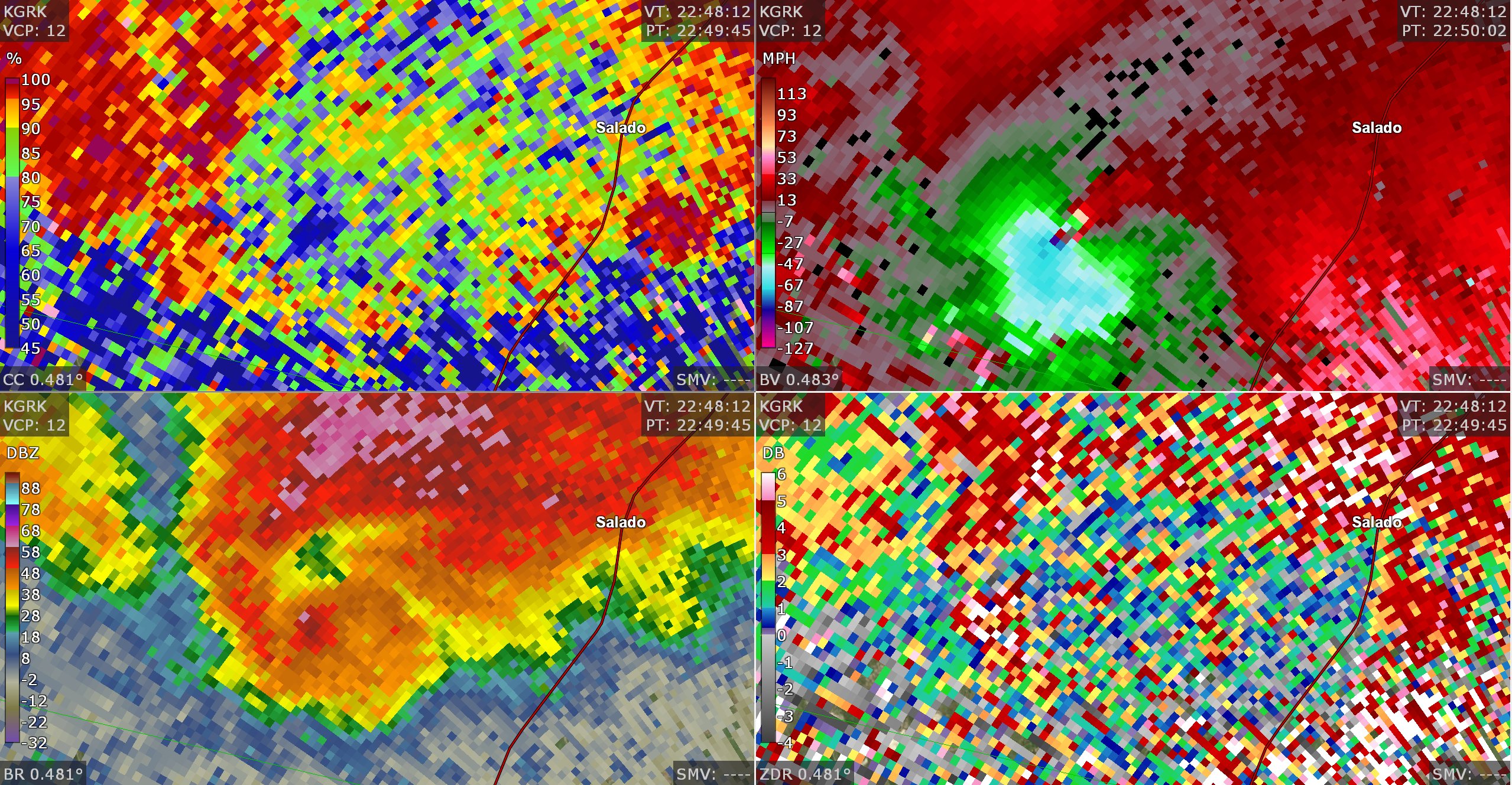
Someone else on a different forum said it's 98 mph inbound & 96 mph outbound. 
0 likes
Bill 2015 & Beta 2020
Winter 2020-2021
All observations are in Tecumseh, OK unless otherwise noted.
Winter posts are focused mainly for Oklahoma & Texas.
Take any of my forecasts with a grain of salt, refer to the NWS, SPC, and NHC for official information
Never say Never with weather! Because ANYTHING is possible!
Winter 2020-2021
All observations are in Tecumseh, OK unless otherwise noted.
Winter posts are focused mainly for Oklahoma & Texas.
Take any of my forecasts with a grain of salt, refer to the NWS, SPC, and NHC for official information
Never say Never with weather! Because ANYTHING is possible!
-
Texas Snowman
- Storm2k Moderator
- Posts: 6197
- Joined: Fri Jan 25, 2008 11:29 am
- Location: Denison, Texas
Re: Texas Spring 2022
Severe Weather Statement
National Weather Service Fort Worth TX
555 PM CDT Tue Apr 12 2022
TXC027-122315-
/O.CON.KFWD.TO.W.0035.000000T0000Z-220412T2315Z/
Bell TX-
555 PM CDT Tue Apr 12 2022
...A TORNADO WARNING REMAINS IN EFFECT UNTIL 615 PM CDT FOR CENTRAL
BELL COUNTY...
At 554 PM CDT, a confirmed large and extremely dangerous tornado was
located near Salado, moving east at 30 mph. This tornado will cross
Interstate 35 near Salado and is headed toward Salado. Seek shelter
now!
This is a PARTICULARLY DANGEROUS SITUATION. TAKE COVER NOW!
HAZARD...Damaging tornado.
SOURCE...Radar confirmed tornado.
IMPACT...You are in a life-threatening situation. Flying debris may
be deadly to those caught without shelter. Mobile homes
will be destroyed. Considerable damage to homes,
businesses, and vehicles is likely and complete destruction
is possible.
PRECAUTIONARY/PREPAREDNESS ACTIONS...
This is an emergency situation. A large and extremely dangerous
tornado is on the ground. Take immediate tornado precautions now and
head into a small interior room on the lowest floor! Use blankets or
pillows to cover your head.
&&
LAT...LON 3087 9753 3088 9763 3090 9767 3100 9768
3116 9748 3088 9745
TIME...MOT...LOC 2254Z 247DEG 25KT 3094 9760
TORNADO...OBSERVED
TORNADO DAMAGE THREAT...CONSIDERABLE
MAX HAIL SIZE...1.75 IN
0 likes
The above post and any post by Texas Snowman is NOT an official forecast and should not be used as such. It is just the opinion of the poster and may or may not be backed by sound meteorological data. It is NOT endorsed by any professional institution including storm2k.org. For official information, please refer to NWS products.
-
ElectricStorm

- Category 5
- Posts: 5145
- Age: 25
- Joined: Tue Aug 13, 2019 11:23 pm
- Location: Norman, OK
Re: Texas Spring 2022
The storms south of it are racing towards it. Hopefully they can cut it off before it reaches the town and interstate
0 likes
B.S Meteorology, University of Oklahoma '25
Please refer to the NHC, NWS, or SPC for official information.
Please refer to the NHC, NWS, or SPC for official information.
-
Texas Snowman
- Storm2k Moderator
- Posts: 6197
- Joined: Fri Jan 25, 2008 11:29 am
- Location: Denison, Texas
Re: Texas Spring 2022
@NWSFortWorth — 5:52pm: Potentially violent tornado west of Salado is ongoing now! This is a life threatening situation! If you are in this area: Get in a bathtub in an interior room with no windows, put pillows or a mattress over your self. Bicycle helmets are good too! #ctxwx
0 likes
The above post and any post by Texas Snowman is NOT an official forecast and should not be used as such. It is just the opinion of the poster and may or may not be backed by sound meteorological data. It is NOT endorsed by any professional institution including storm2k.org. For official information, please refer to NWS products.
-
Iceresistance
- Category 5
- Posts: 9581
- Age: 22
- Joined: Sat Oct 10, 2020 9:45 am
- Location: Tecumseh, OK/Norman, OK
Re: Texas Spring 2022
Iceresistance wrote:Someone else on a different forum said it's 98 mph inbound & 96 mph outbound &.
It's 196 mph Gate to Gate Shear, very powerful tornado on the ground!
0 likes
Bill 2015 & Beta 2020
Winter 2020-2021
All observations are in Tecumseh, OK unless otherwise noted.
Winter posts are focused mainly for Oklahoma & Texas.
Take any of my forecasts with a grain of salt, refer to the NWS, SPC, and NHC for official information
Never say Never with weather! Because ANYTHING is possible!
Winter 2020-2021
All observations are in Tecumseh, OK unless otherwise noted.
Winter posts are focused mainly for Oklahoma & Texas.
Take any of my forecasts with a grain of salt, refer to the NWS, SPC, and NHC for official information
Never say Never with weather! Because ANYTHING is possible!
-
Texas Snowman
- Storm2k Moderator
- Posts: 6197
- Joined: Fri Jan 25, 2008 11:29 am
- Location: Denison, Texas
Re: Texas Spring 2022
@CC_StormWatch — There are #tornado shelters at the rest areas at Mile Markets 281-282 (both directions) on I-35 near Salado. If you know someone on I-35 heading that way, tell them to park there and get in there. #TXwx
1 likes
The above post and any post by Texas Snowman is NOT an official forecast and should not be used as such. It is just the opinion of the poster and may or may not be backed by sound meteorological data. It is NOT endorsed by any professional institution including storm2k.org. For official information, please refer to NWS products.
-
Iceresistance
- Category 5
- Posts: 9581
- Age: 22
- Joined: Sat Oct 10, 2020 9:45 am
- Location: Tecumseh, OK/Norman, OK
Re: Texas Spring 2022
Supercell is getting muddy, the other storms are really disrupting it, possibly a very close call for Salado
0 likes
Bill 2015 & Beta 2020
Winter 2020-2021
All observations are in Tecumseh, OK unless otherwise noted.
Winter posts are focused mainly for Oklahoma & Texas.
Take any of my forecasts with a grain of salt, refer to the NWS, SPC, and NHC for official information
Never say Never with weather! Because ANYTHING is possible!
Winter 2020-2021
All observations are in Tecumseh, OK unless otherwise noted.
Winter posts are focused mainly for Oklahoma & Texas.
Take any of my forecasts with a grain of salt, refer to the NWS, SPC, and NHC for official information
Never say Never with weather! Because ANYTHING is possible!
-
Texas Snowman
- Storm2k Moderator
- Posts: 6197
- Joined: Fri Jan 25, 2008 11:29 am
- Location: Denison, Texas
Re: Texas Spring 2022
@MyRadarWX — Some encouraging news — the tornado has now taken a left/northward turn, ordinarily a sign that the twister is beginning to approach the end of its life.
That said, the storm could “cycle” and produce a new tornado. Remain sheltered if near Salado.
Been ongoing for 30+ min.
That said, the storm could “cycle” and produce a new tornado. Remain sheltered if near Salado.
Been ongoing for 30+ min.
0 likes
The above post and any post by Texas Snowman is NOT an official forecast and should not be used as such. It is just the opinion of the poster and may or may not be backed by sound meteorological data. It is NOT endorsed by any professional institution including storm2k.org. For official information, please refer to NWS products.


-
Texas Snowman
- Storm2k Moderator
- Posts: 6197
- Joined: Fri Jan 25, 2008 11:29 am
- Location: Denison, Texas
Re: Texas Spring 2022
Severe Weather Statement
National Weather Service Fort Worth TX
606 PM CDT Tue Apr 12 2022
TXC027-122315-
/O.CON.KFWD.TO.W.0035.000000T0000Z-220412T2315Z/
Bell TX-
606 PM CDT Tue Apr 12 2022
...A TORNADO WARNING REMAINS IN EFFECT UNTIL 615 PM CDT FOR CENTRAL
BELL COUNTY...
At 605 PM CDT, a tornado was located near Harker Heights, moving
north at 30 mph. This tornado will cross FM 2484 west of Salado.
This is a PARTICULARLY DANGEROUS SITUATION. TAKE COVER NOW!
HAZARD...Damaging tornado.
SOURCE...Radar indicated rotation.
IMPACT...You are in a life-threatening situation. Flying debris may
be deadly to those caught without shelter. Mobile homes
will be destroyed. Considerable damage to homes,
businesses, and vehicles is likely and complete destruction
is possible.
PRECAUTIONARY/PREPAREDNESS ACTIONS...
To repeat, a large, extremely dangerous and potentially deadly
tornado is developing. To protect your life, TAKE COVER NOW! Move to
an interior room on the lowest floor of a sturdy building and avoid
windows. If you are outdoors or in a vehicle, move to the closest
substantial shelter and protect yourself from flying debris.
&&
LAT...LON 3087 9753 3088 9763 3090 9767 3100 9768
3116 9748 3088 9745
TIME...MOT...LOC 2305Z 186DEG 28KT 3099 9762
TORNADO...RADAR INDICATED
TORNADO DAMAGE THREAT...CONSIDERABLE
MAX HAIL SIZE...1.50 IN
0 likes
The above post and any post by Texas Snowman is NOT an official forecast and should not be used as such. It is just the opinion of the poster and may or may not be backed by sound meteorological data. It is NOT endorsed by any professional institution including storm2k.org. For official information, please refer to NWS products.
-
ElectricStorm
- Category 5
- Posts: 5145
- Age: 25
- Joined: Tue Aug 13, 2019 11:23 pm
- Location: Norman, OK
Re: Texas Spring 2022
0 likes
B.S Meteorology, University of Oklahoma '25
Please refer to the NHC, NWS, or SPC for official information.
Please refer to the NHC, NWS, or SPC for official information.
-
UTSARoadrunner4
- Category 1

- Posts: 265
- Age: 29
- Joined: Wed Aug 26, 2020 11:19 pm
Re: Texas Spring 2022
Looks like Salado may’ve just dodged a bullet. That north hook at the end has me worried for Belton & Temple though
0 likes
-
Texas Snowman
- Storm2k Moderator
- Posts: 6197
- Joined: Fri Jan 25, 2008 11:29 am
- Location: Denison, Texas
Re: Texas Spring 2022
@NWSFortWorth — 610pm: The tornado over southern Bell county appears to have lifted. The tornado threat has ended for at least the next few minutes, so the tornado warning will expire at 615pm. However the storm remains, and a new warning could be issued if rotation increases again. #ctxwx
0 likes
The above post and any post by Texas Snowman is NOT an official forecast and should not be used as such. It is just the opinion of the poster and may or may not be backed by sound meteorological data. It is NOT endorsed by any professional institution including storm2k.org. For official information, please refer to NWS products.

Re: Texas Spring 2022
Lots of thunder and lightning here in Arlington, with a nice soaking rain.
0 likes
Re: Texas Spring 2022
If you have my radar on your phone. Sean Cobb has a good spot with well defined wall cloud on the storm.
0 likes
-
Texas Snowman
- Storm2k Moderator
- Posts: 6197
- Joined: Fri Jan 25, 2008 11:29 am
- Location: Denison, Texas
Re: Texas Spring 2022
@spotternetwork — Spotr 8 miles NNW of JARRELL, TX @ 23:29 UTC Damage>-Cedar Valley Road and FM 2843 with multiple structures damaged, power line poles snapped, multiple trees down from tornado damage.
0 likes
The above post and any post by Texas Snowman is NOT an official forecast and should not be used as such. It is just the opinion of the poster and may or may not be backed by sound meteorological data. It is NOT endorsed by any professional institution including storm2k.org. For official information, please refer to NWS products.
-
HockeyTx82
- S2K Supporter
- Posts: 2791
- Joined: Tue Oct 27, 2009 11:17 am
- Location: Ponder, TX
Re: Texas Spring 2022
Denton county and points east added to the Tornado watch?
What am I missing?
What am I missing?
1 likes
Don't hold me accountable for anything I post on this forum. Leave the real forecasting up to the professionals.
Location: Ponder, TX (all observation posts are this location unless otherwise noted)
Location: Ponder, TX (all observation posts are this location unless otherwise noted)
Return to “USA & Caribbean Weather”
Who is online
Users browsing this forum: mmmmsnouts and 50 guests