***Extremely dangerous and potentially life threatening flash flood event today-Sunday!***
Flash Flood Watch is in effect
Coastal Flood Warning is now in effect
Gale Warning issued for all coastal waters
Rainfall:
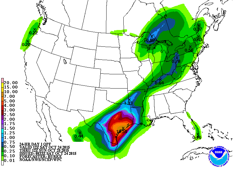
Excessive rainfall event is underway and starting to move into SE TX. Widespread flooding is ongoing over central and north Texas after 5-7 inches of rainfall over C TX this morning. Corsicana, TX has recorded over 18.0 inches and Waco almost 8 inches. Austin has recorded over 6 inches. LCRA is now operating flood gates at Tom Miller Dam.
Factors now in place to produce a potentially devastating flash flood over SE TX from late this morning through noon Sunday…TAKE THIS THREAT SERIOUSLY!
Core of Patricia now over central TX and racing toward S TX and will move right over SE TX tonight and Sunday while a slow moving cold front moves into the area. Excessive rainfall will develop and train over the area with hourly rainfall rates of 3-5 inches for many hours. Will increase storm totals to widespread 9-12 inches with isolated amounts of 15 inches SE of a line from Victoria to Columbus to Cleveland including much of Harris County. NW of this line rainfall amounts of 3-6 inches with isolated totals of 8-10 inches will be possible.
Rainfall of this magnitude will cause very significant flooding.
Tides:
Tides will be on the rise today and reach 4.5-5.5 ft all area tonight. This will result in coastal flooding along much of the upper TX coast. Critical areas will be Bolivar, west Galveston Is, Seabrook, Kemah, Surfside, and Clear Lake.
Tides will remain high into midday Sunday.
Winds:
Will bump winds up a little more on the coast as latest guidance is stronger with 30-45mph likely. Stronger storms will bring wind energy to the surface in strong gust with some up to 50mph possible. Offshore winds sustained at above 40mph look likely…Gale Warning criteria. Wind maximum should be between midnight and 900am Sunday as surface low passes over SE TX.
Actions:
Residents should be prepared for flash flood conditions.
Travel after 300pm this afternoon is not advised
Flooding of structures will becoming increasingly likely across the area. Be prepared to take quick actions from rising water this evening and overnight into Sunday. Flooding may result in areas that normally do not flood to flood.
24-hr Storm Totals: