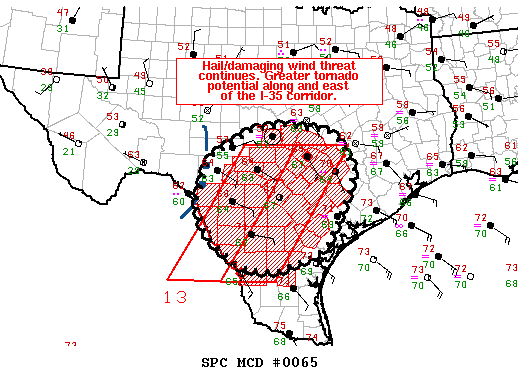
C/S TX Weather: Seasonal with some rains

U.S. & Caribbean Weather Discussions and Severe Weather Events

Moderator: S2k Moderators

Forum rules

The posts in this forum are NOT official forecast and should not be used as such. They are just the opinion of the poster and may or may not be backed by sound meteorological data. They are NOT endorsed by any professional institution or STORM2K.

Help Support Storm2K
Message
Author
User avatar
Rgv20
S2K Supporter
S2K Supporter
Posts: 2458
Age: 37
Joined: Wed Jan 05, 2011 5:42 pm
Location: Edinburg/McAllen Tx

#1321 Postby Rgv20 » Wed Jan 25, 2012 1:07 am

Let me double check the calender....yep its January! :eek: On a side note is down right windy here at my place....McAllen Airport just reported a wind gust of 37mph and Harlingen had a gust of 43mph.

Image++

MESOSCALE DISCUSSION 0065
NWS STORM PREDICTION CENTER NORMAN OK
1134 PM CST TUE JAN 24 2012

AREAS AFFECTED...EDWARDS PLATEAU...HILL COUNTRY...S-CNTRL TX

CONCERNING...TORNADO WATCH 13...

VALID 250534Z - 250630Z

THE SEVERE WEATHER THREAT FOR TORNADO WATCH 13 CONTINUES.

PRIMARILY A SEVERE HAIL/DAMAGING WIND THREAT EXISTS WITH DEVELOPING
LINEAR MCS ALONG AND IMMEDIATELY W OF WW 13 OVER THE EDWARDS
PLATEAU. ADDITIONAL TSTMS SHOULD STRENGTHEN ACROSS S-CNTRL TX NEAR
LRD THROUGH EARLY MORNING...AND WOULD POSE A MORE SUBSTANTIAL
HAIL/TORNADO RISK.

WELL-ADVERTISED LINEAR MCS INVOF EDWARDS/KINNEY COUNTIES SHOULD
CONTINUE TO EXPAND E/NEWD ACROSS THE EDWARDS PLATEAU/HILL COUNTRY
WITHIN A ZONE OF FOCUSED ASCENT DOWNSTREAM OF MID-LEVEL IMPULSE
CENTERED OVER FAR W TX. RECENT SURFACE ANALYSES INDICATE THAT THIS
CLUSTER HAS REMAINED LARGELY POST-FRONTAL THUS FAR...PRIMARILY
POSING A SEVERE HAIL THREAT. AS ASCENT OVERSPREADS THE BROADER WARM
SECTOR...ADDITIONAL DEVELOPMENT ALONG/JUST AHEAD OF THE SURFACE
FRONT APPEARS PROBABLE...YIELDING A MIX OF ISOLATED SEVERE
HAIL/DAMAGING WIND THREATS AND PERHAPS A BRIEF TORNADO.

MID-LEVEL CONVECTION HAS BEEN INCREASING FARTHER SE TOWARDS
LRD...WITH INCIPIENT TSTM DEVELOPMENT APPEARING TO BE UNDERWAY.
GIVEN A MUCH BROADER WARM/MOIST SECTOR ALONG WITH STRONG SLYS AOA 30
KT ALONG AND E OF THE I-35 CORRIDOR...THIS SETUP SHOULD BE FAVORABLE
FOR SUPERCELLS CAPABLE OF PRODUCING TORNADOES AND LARGE HAIL.

..GRAMS.. 01/25/2012


ATTN...WFO...HGX...FWD...CRP...EWX...SJT...

LAT...LON 30040044 30320025 30889925 31039840 30879710 30569673
30289667 29929646 29339663 28239720 27999753 27719823
27629847 27629901 27669934 27829968 28380039 29120073
30040044
0 likes   
The following post is NOT an official forecast and should not be used as such. It is just the opinion of the poster and may or may not be backed by sound meteorological data. It is NOT endorsed by any professional institution including storm2k.org For Official Information please refer to the NHC and NWS products.

Shoshana
Category 5
Category 5
Posts: 1409
Joined: Thu Sep 09, 2004 7:50 pm
Location: NE Austin

Re: C/S TX Weather: Seasonal with some rains

#1322 Postby Shoshana » Wed Jan 25, 2012 6:11 pm

We got 3.5" of rain so far .... cool.
0 likes   

User avatar
cycloneye
Admin
Admin
Posts: 139704
Age: 67
Joined: Thu Oct 10, 2002 10:54 am
Location: San Juan, Puerto Rico

Re: C/S TX Weather: Seasonal with some rains

#1323 Postby cycloneye » Wed Jan 25, 2012 7:15 pm

Wow,from a dry pattern to a wet one and look at what extreme weather can do. This is in Fort Worth.

Image
0 likes   
Visit the Caribbean-Central America Weather Thread where you can find at first post web cams,radars
and observations from Caribbean basin members Click Here

Shoshana
Category 5
Category 5
Posts: 1409
Joined: Thu Sep 09, 2004 7:50 pm
Location: NE Austin

#1324 Postby Shoshana » Thu Jan 26, 2012 4:22 am

There was a tornado in Austin within abt 2 miles of our house. As far as I can tell there was no tornado warnings issued.
0 likes   

User avatar
Portastorm
Storm2k Moderator
Storm2k Moderator
Posts: 9788
Age: 62
Joined: Fri Jul 11, 2003 9:16 am
Location: South Austin, TX
Contact:

Re:

#1325 Postby Portastorm » Thu Jan 26, 2012 7:28 am

Shoshana wrote:There was a tornado in Austin within abt 2 miles of our house. As far as I can tell there was no tornado warnings issued.


Shoshana ... while we were under a Tornado Watch at the time, you are correct. No warning was issued. The tornado touched down near 290/Springdale, was 50 yards wide, and lasted about 1.1 miles. How did you do in the rainfall department? We got about 3.4 inches here at the Portastorm Weather Center in scenic southwest Austin.
0 likes   
Any forecasts under my name are to be taken with a grain of salt. Get your best forecasts from the National Weather Service and National Hurricane Center.

I'm a certified Advanced SKYWARN-trained spotter and am active on Twitter at @TravisCOSW, a social media partner of the NWS Austin-San Antonio office.

Shoshana
Category 5
Category 5
Posts: 1409
Joined: Thu Sep 09, 2004 7:50 pm
Location: NE Austin

Re: Re:

#1326 Postby Shoshana » Mon Jan 30, 2012 12:13 am

Portastorm wrote:
Shoshana wrote:There was a tornado in Austin within abt 2 miles of our house. As far as I can tell there was no tornado warnings issued.


Shoshana ... while we were under a Tornado Watch at the time, you are correct. No warning was issued. The tornado touched down near 290/Springdale, was 50 yards wide, and lasted about 1.1 miles. How did you do in the rainfall department? We got about 3.4 inches here at the Portastorm Weather Center in scenic southwest Austin.


We got 3.5" ... and the loudest thunderstorm I've heard in years. There was some kind of flood warning issued (I can't remember if it was a flash flood warning or just a flood warning) that set off my weather radio right around the time of the worst storming. I couldn't sleep till it was all over, Husband slept thru the entire thing.

We are pretty much due north of where the tornado was, and it seemed to be (from the tracks) heading a bit NE.
0 likes   

User avatar
Portastorm
Storm2k Moderator
Storm2k Moderator
Posts: 9788
Age: 62
Joined: Fri Jul 11, 2003 9:16 am
Location: South Austin, TX
Contact:

Re: C/S TX Weather: Seasonal with some rains

#1327 Postby Portastorm » Mon Jan 30, 2012 2:09 pm

Funny you should mention that (the loudness element) ... my brother, who lives in Pflugerville, and I were talking the day after the storm. We both remarked to each other how loud it was (my house literally shook to the foundation several times from thunder after a close lightning strike) and we wondered if it was a matter of us not having any real storms in several years (due to the drought) or if that storm particularly was indeed that LOUD!!
0 likes   
Any forecasts under my name are to be taken with a grain of salt. Get your best forecasts from the National Weather Service and National Hurricane Center.

I'm a certified Advanced SKYWARN-trained spotter and am active on Twitter at @TravisCOSW, a social media partner of the NWS Austin-San Antonio office.

User avatar
Portastorm
Storm2k Moderator
Storm2k Moderator
Posts: 9788
Age: 62
Joined: Fri Jul 11, 2003 9:16 am
Location: South Austin, TX
Contact:

Re: C/S TX Weather: Seasonal with some rains

#1328 Postby Portastorm » Fri Feb 03, 2012 9:49 am

Could see some decent storms later today/tonight along the I-35 corridor:

HAZARDOUS WEATHER OUTLOOK
NATIONAL WEATHER SERVICE AUSTIN/SAN ANTONIO TX
555 AM CST FRI FEB 3 2012

TXZ171>173-183>194-202>209-217>225-228-041200-
LLANO-BURNET-WILLIAMSON-VAL VERDE-EDWARDS-REAL-KERR-BANDERA-
GILLESPIE-KENDALL-BLANCO-HAYS-TRAVIS-BASTROP-LEE-KINNEY-UVALDE-
MEDINA-BEXAR-COMAL-GUADALUPE-CALDWELL-FAYETTE-MAVERICK-ZAVALA-
FRIO-ATASCOSA-WILSON-KARNES-GONZALES-DE WITT-LAVACA-DIMMIT-
555 AM CST FRI FEB 3 2012

THIS HAZARDOUS WEATHER OUTLOOK IS FOR SOUTH CENTRAL TEXAS.

.DAY ONE...TODAY AND TONIGHT...
THERE IS A SLIGHT RISK OF SEVERE THUNDERSTORMS TONIGHT ACROSS
PORTIONS OF SOUTH CENTRAL TEXAS ALONG AND NORTH OF A ROCKSPRINGS
TO SABINAL TO SAN ANTONIO TO TAYLOR LINE. AN UPPER LEVEL
DISTURBANCE AND AN ASSOCIATED COLD FRONT WILL LIKELY PRODUCE A
COMPLEX OF THUNDERSTORMS...WITH A POTENTIAL FOR LARGE HAIL AND
DAMAGING WINDS AS THE PRIMARY SEVERE THREATS.

AFTER MIDNIGHT TONIGHT...THIS DEVELOPING COMPLEX OF THUNDERSTORMS
WILL HAVE A POTENTIAL TO PRODUCE LOCALLY HEAVY RAINS IN EXCESS OF
2 INCHES...MAINLY EAST OF A TAYLOR TO SEGUIN TO CUERO LINE.

.DAYS TWO THROUGH SEVEN...SATURDAY THROUGH THURSDAY...
NO HAZARDOUS WEATHER IS EXPECTED.

.SPOTTER INFORMATION STATEMENT...
SPOTTER ACTIVATION MAY BECOME NECESSARY THIS EVENING THROUGH LATE
TONIGHT.
0 likes   
Any forecasts under my name are to be taken with a grain of salt. Get your best forecasts from the National Weather Service and National Hurricane Center.

I'm a certified Advanced SKYWARN-trained spotter and am active on Twitter at @TravisCOSW, a social media partner of the NWS Austin-San Antonio office.

User avatar
Portastorm
Storm2k Moderator
Storm2k Moderator
Posts: 9788
Age: 62
Joined: Fri Jul 11, 2003 9:16 am
Location: South Austin, TX
Contact:

Re: C/S TX Weather: Seasonal with some rains

#1329 Postby Portastorm » Fri Feb 03, 2012 1:52 pm

Heavy rain looking more and more likely ...

FLOOD WATCH...UPDATED
NATIONAL WEATHER SERVICE AUSTIN/SAN ANTONIO TX
1232 PM CST FRI FEB 3 2012

...FLASH FLOOD WATCH FOR AREAS ALONG AND EAST OF THE I-
35 CORRIDOR FROM 8 PM THIS EVENING THROUGH NOON TOMORROW...

.A MASSIVE WINTER STORM SYSTEM OVER THE ROCKIES AND U.S. PLAINS
WILL PUSH A COLD FRONT INTO SOUTH CENTRAL TEXAS THIS EVENING.
THIS COLD FRONT IS EXPECTED TO INTERACT WITH AN UNSEASONABLY WARM
AND VERY MOIST AIRMASS TO PRODUCE HEAVY RAINS LATE TONIGHT INTO
EARLY SATURDAY MORNING. WITH ALREADY WET GROUNDS FROM HEAVY RAINS
OF THE LAST STORM SYSTEM...RUNOFF WILL BE QUICK LEADING TO
LOCALIZED FLOODING IN THE WATCH AREA.

TXC013-021-029-055-091-123-149-177-187-209-255-285-287-453-491-
493-040245-
/O.CON.KEWX.FF.A.0001.120204T0200Z-120204T1800Z/
/00000.0.ER.000000T0000Z.000000T0000Z.000000T0000Z.OO/
ATASCOSA-BASTROP-BEXAR-CALDWELL-COMAL-DEWITT-FAYETTE-GONZALES-
GUADALUPE-HAYS-KARNES-LAVACA-LEE-TRAVIS-WILLIAMSON-WILSON-
INCLUDING THE CITIES OF...PLEASANTON...BASTROP...SAN ANTONIO...
LOCKHART...NEW BRAUNFELS...CUERO...LA GRANGE...GONZALES...
SEGUIN...SAN MARCOS...KARNES CITY...HALLETTSVILLE...GIDDINGS...
AUSTIN...GEORGETOWN...FLORESVILLE
1232 PM CST FRI FEB 3 2012

...FLASH FLOOD WATCH REMAINS IN EFFECT FROM 8 PM CST THIS EVENING
THROUGH SATURDAY MORNING...

THE FLASH FLOOD WATCH CONTINUES FOR

* THE FOLLOWING COUNTIES IN SOUTH CENTRAL TEXAS...ATASCOSA...
BASTROP...BEXAR...CALDWELL...COMAL...DEWITT...FAYETTE...
GONZALES...GUADALUPE...HAYS...KARNES...LAVACA...LEE...TRAVIS...
WILLIAMSON AND WILSON.

* FROM 8 PM CST THIS EVENING THROUGH SATURDAY MORNING

* A MASSIVE WINTER STORM SYSTEM OVER THE ROCKIES AND U.S. PLAINS
WILL PUSH A COLD FRONT INTO SOUTH CENTRAL TEXAS THIS EVENING.
THIS COLD FRONT IS EXPECTED TO INTERACT WITH AN UNSEASONABLY
WARM AND VERY MOIST AIRMASS TO PRODUCE HEAVY RAINS LATE TONIGHT
INTO EARLY SATURDAY MORNING. WITH ALREADY WET GROUNDS FROM HEAVY
RAINS OF THE LAST STORM SYSTEM...RUNOFF WILL BE QUICK LEADING TO
LOCALIZED FLOODING IN THE WATCH AREA. RAIN AMOUNTS WILL AVERAGE
ONE TO TWO INCHES WITH ISOLATED THREE INCH PLUS AMOUNTS OVER THE
WATCH AREA.

* THE HEAVY RAINS EXPECTED MAY PRODUCE SIGNIFICANT RISES ON AREA
RIVERS AND STREAMS WITH THE GREATEST THREAT OVER THE LOWER
GUADALUPE...SAN ANTONIO AND LAVACA NAVIDAD RIVER BASINS.

PRECAUTIONARY/PREPAREDNESS ACTIONS...

A FLASH FLOOD WATCH MEANS FLASH FLOODING IS POSSIBLE IN OR NEAR
THE WATCH AREA. IF YOU ARE IN THE WATCH AREA...PLAN NOW FOR WHAT
YOU WILL DO IF FLASH FLOODING DEVELOPS. STAY INFORMED AND BE
READY TO ACT IF YOU SEE FLOODING OR IF A FLASH FLOOD WARNING IS
ISSUED.
0 likes   
Any forecasts under my name are to be taken with a grain of salt. Get your best forecasts from the National Weather Service and National Hurricane Center.

I'm a certified Advanced SKYWARN-trained spotter and am active on Twitter at @TravisCOSW, a social media partner of the NWS Austin-San Antonio office.

User avatar
Portastorm
Storm2k Moderator
Storm2k Moderator
Posts: 9788
Age: 62
Joined: Fri Jul 11, 2003 9:16 am
Location: South Austin, TX
Contact:

#1330 Postby Portastorm » Sat Feb 04, 2012 10:05 am

Well ... shoot ... only picked up about a half inch at the Portastorm Weather Center. I do see that the eastern end of the county received about 1.5 inches. Still, I won't sniff at any rain at this point. It's a beautiful thing. :D
0 likes   
Any forecasts under my name are to be taken with a grain of salt. Get your best forecasts from the National Weather Service and National Hurricane Center.

I'm a certified Advanced SKYWARN-trained spotter and am active on Twitter at @TravisCOSW, a social media partner of the NWS Austin-San Antonio office.

Shoshana
Category 5
Category 5
Posts: 1409
Joined: Thu Sep 09, 2004 7:50 pm
Location: NE Austin

#1331 Postby Shoshana » Sun Feb 05, 2012 11:48 pm

We also got .5" ... it sounded like more but it was mostly lightning and thunder.
0 likes   

User avatar
cycloneye
Admin
Admin
Posts: 139704
Age: 67
Joined: Thu Oct 10, 2002 10:54 am
Location: San Juan, Puerto Rico

Re: C/S TX Weather: Seasonal with some rains

#1332 Postby cycloneye » Tue Feb 07, 2012 1:00 pm

Texas ranks as the second state with the most rainfall in January and that of course is great news.

Image
0 likes   
Visit the Caribbean-Central America Weather Thread where you can find at first post web cams,radars
and observations from Caribbean basin members Click Here

User avatar
Rgv20
S2K Supporter
S2K Supporter
Posts: 2458
Age: 37
Joined: Wed Jan 05, 2011 5:42 pm
Location: Edinburg/McAllen Tx

#1333 Postby Rgv20 » Wed Feb 08, 2012 10:59 pm

Rain glorious Rain!! :D

Image
Drought...dented? For the Lower Valley, we're on our way. More than 2 inches has fallen in most of Cameron and Willacy County, and the Highway 83 corridor has done nicely with some areas over two inches and counting at 9 AM Thursday morning. Stat of the morning: Brownsville had reached 2.71 inches at 9 AM, now ranked #2 all time for the wettest first half of February, and there's more rain coming through the 11th. How much more to #1? Less than an inch. McAllen/Miller (since 1961) is less than 0.6 inches from matching its all time 15 day total of 2.28 set in 1977.
0 likes   
The following post is NOT an official forecast and should not be used as such. It is just the opinion of the poster and may or may not be backed by sound meteorological data. It is NOT endorsed by any professional institution including storm2k.org For Official Information please refer to the NHC and NWS products.

Shoshana
Category 5
Category 5
Posts: 1409
Joined: Thu Sep 09, 2004 7:50 pm
Location: NE Austin

#1334 Postby Shoshana » Sun Feb 12, 2012 5:28 am

28F ... amazing
0 likes   

Shoshana
Category 5
Category 5
Posts: 1409
Joined: Thu Sep 09, 2004 7:50 pm
Location: NE Austin

#1335 Postby Shoshana » Sat Feb 18, 2012 2:32 am

Hail, sounds little. We had sleet a few days ago (2/12)
0 likes   

User avatar
Portastorm
Storm2k Moderator
Storm2k Moderator
Posts: 9788
Age: 62
Joined: Fri Jul 11, 2003 9:16 am
Location: South Austin, TX
Contact:

Re: C/S TX Weather: Seasonal with some rains

#1336 Postby Portastorm » Sat Feb 18, 2012 8:48 am

A little more than 2.3 inches of rain in the last 24 hours at the Portastorm Weather Center. Whoo! :D
0 likes   
Any forecasts under my name are to be taken with a grain of salt. Get your best forecasts from the National Weather Service and National Hurricane Center.

I'm a certified Advanced SKYWARN-trained spotter and am active on Twitter at @TravisCOSW, a social media partner of the NWS Austin-San Antonio office.

User avatar
Rgv20
S2K Supporter
S2K Supporter
Posts: 2458
Age: 37
Joined: Wed Jan 05, 2011 5:42 pm
Location: Edinburg/McAllen Tx

#1337 Postby Rgv20 » Sat Feb 18, 2012 11:39 am

The wind is howling in my backyard! Gusts has been easily in the 40mph+ range :double:
0 likes   
The following post is NOT an official forecast and should not be used as such. It is just the opinion of the poster and may or may not be backed by sound meteorological data. It is NOT endorsed by any professional institution including storm2k.org For Official Information please refer to the NHC and NWS products.

User avatar
Portastorm
Storm2k Moderator
Storm2k Moderator
Posts: 9788
Age: 62
Joined: Fri Jul 11, 2003 9:16 am
Location: South Austin, TX
Contact:

Re:

#1338 Postby Portastorm » Sat Feb 18, 2012 11:58 am

Rgv20 wrote:The wind is howling in my backyard! Gusts has been easily in the 40mph+ range :double:


Sounds like the NWS forecast you showed us yesterday is verifying. Not surprised. The upper-level low moving across Texas (not to mention the surface reflection in the Gulf) is sucking up that RGV air into it!
0 likes   
Any forecasts under my name are to be taken with a grain of salt. Get your best forecasts from the National Weather Service and National Hurricane Center.

I'm a certified Advanced SKYWARN-trained spotter and am active on Twitter at @TravisCOSW, a social media partner of the NWS Austin-San Antonio office.

User avatar
Rgv20
S2K Supporter
S2K Supporter
Posts: 2458
Age: 37
Joined: Wed Jan 05, 2011 5:42 pm
Location: Edinburg/McAllen Tx

#1339 Postby Rgv20 » Sat Feb 18, 2012 12:13 pm

:uarrow: Surprisingly the lower valley looks like they are going to miss out on the stronger winds.....Usually they get the stronger winds and my area (upper valley) we only get 25+ winds.


Changing the subject, the Seasonal ECMWF is forecasting above normal Sea Level Pressure for the GOM come June thru August....Hurricane Season is coming up fast! :cheesy:
Image
0 likes   
The following post is NOT an official forecast and should not be used as such. It is just the opinion of the poster and may or may not be backed by sound meteorological data. It is NOT endorsed by any professional institution including storm2k.org For Official Information please refer to the NHC and NWS products.

User avatar
somethingfunny
ChatStaff
ChatStaff
Posts: 3926
Age: 36
Joined: Thu May 31, 2007 10:30 pm
Location: McKinney, Texas

Re: C/S TX Weather: Seasonal with some rains

#1340 Postby somethingfunny » Sun Feb 19, 2012 3:43 pm

Rain totals over the past seven days:

Image
0 likes   
I am not a meteorologist, and any posts made by me are not official forecasts or to be interpreted as being intelligent. These posts are just my opinions and are probably silly opinions.


Return to “USA & Caribbean Weather”

Who is online

Users browsing this forum: No registered users and 40 guests