StormingB81 wrote:I feel like Im doing to get a whole bunch of nothing... near the space coast
That's what you should expect and the forecast pretty much reflects that
Moderator: S2k Moderators

StormingB81 wrote:I feel like Im doing to get a whole bunch of nothing... near the space coast


TheStormExpert wrote:With a storm system this big and wide in coverage one has to wonder why is the southern half of the FL Peninsula missing out? We're on the verge of an El Niño in a El Niño behaving winter so what are we missing? Anyone have any input?
https://media.giphy.com/media/9P96RAnoXwV93DgnbK/giphy.gif

URGENT - IMMEDIATE BROADCAST REQUESTED
Severe Thunderstorm Watch Number 438
NWS Storm Prediction Center Norman OK
405 PM EST Fri Dec 14 2018
The NWS Storm Prediction Center has issued a
* Severe Thunderstorm Watch for portions of
Central Florida
Coastal Waters
* Effective this Friday afternoon and evening from 405 PM until
1000 PM EST.
* Primary threats include...
Scattered damaging wind gusts to 70 mph possible
A tornado or two possible
SUMMARY...A line of strong thunderstorms is approaching the west
coast of central Florida. These storms will move across the watch
area, posing the risk of locally damaging wind gusts and perhaps a
tornado.
The severe thunderstorm watch area is approximately along and 50
statute miles north and south of a line from 80 miles east northeast
of Saint Petersburg FL to 35 miles west northwest of Sarasota FL.
For a complete depiction of the watch see the associated watch
outline update (WOUS64 KWNS WOU8).

floridasun78 wrote:going feel like Christmas here in south fl now only 68 that low for this time a day look front not clear area yet very cloudy we going drop to low 50 and tue too low 50 too and little warm up and drop low 60s on Friday put i see if that chance by wed and miami weather service saying could see strong storm with weekend front so likely whole state could see strong storms doing weekend
SFLcane wrote:Unbelievable what is going on!!?? Every single system Just poofs south of the lake

northjaxpro wrote::uarrow: Well, we certainly were waterlogged for the entire yesterday for sure. It rained continuosly for 27 consecutive hours from 1a.m. yesterday morning through 4 a.m. this morning. The total rainfall was 2.4 inches ending this morning at my locale.It is remarkable the rain amounts were not significantly more considering the long duration of this event. It was mostly light to steady rain the entire event for the Jax metro area. However, other than having a local nor'easter or .a tropical cyclone, I can not recall having an all day long continuous rain. There were some spots which picked up heavier amounts of upward to 5 inches of rainfall, mainly down around Gainesville to Palatka.
Thankfully, the atmosphere stayed stable to keep severe weather out of our area for the event. BTW, since Nov. 1, I have measured now just over 10 inches of rainfall at my home, including yesterday. This is amazing since November and December normally are among our driest months of the year. The El Nino pattern has definitely given us plenty of rain up here this Fall and early Winter for sure.
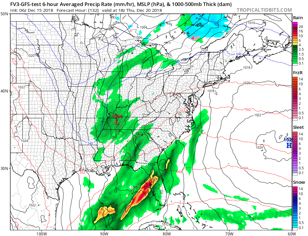
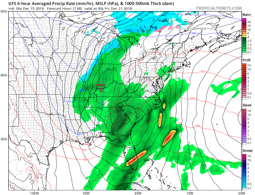
The southern branch of the jet stream just has not shifted far enough south just yet for the storms to really impact extreme South Florida. This hopefully will change as we get into January and February.
We finally get a break up here with the rain gone for now until our next southern stream system comes down the pike. We will have nice, seasonable days temp wise with highs in the 60s and lows in the low-mid 40s up at least through Tuesday. GFS is showing potential rain moving back in possibly by Thursday for the peninsula.
Also, this morning's 06Z GFS run is showing a deep upper level trough carving itself out across the Eastern CONUS by next weekend. This may bring another potential freeze up here across the North Florida area, if this GFS run comes close to verifying.
boca wrote:SFLcane wrote:Unbelievable what is going on!!?? Every single system Just poofs south of the lake
It’s amaxong with a El Niño that we can’t get rain south of lake O. It just dries up.Why?? Even if we had a La Niña we would still get rain. All the canals, lakes, and ponds are all way down. Let’s hope the pattern changes because north and central Florida are water logged and we are in a moderate drought, soon to be severe.
boca wrote:What is amazomg that we are in a drought and north and central Florida are water logged.
Return to “USA & Caribbean Weather”
Users browsing this forum: Google Adsense [Bot], Iceresistance, Stratton23, WeatherP1 and 64 guests
