Page 671 of 883
Re: Florida Weather
Posted: Sat Dec 15, 2018 12:04 pm
by Bocadude85
boca wrote:What is amazomg that we are in a drought and north and central Florida are water logged.
You had to have finally got some rain this morning, it was pouring when I was out in West Boca earlier.
Re: Florida Weather
Posted: Sat Dec 15, 2018 1:01 pm
by gatorcane
Looks like a large area of moderate rain has developed over the southern tip of Florida and heading north and northeast. Welcome rains for sure. Question is does it make it up to Palm Beach County?
Re: Florida Weather
Posted: Sat Dec 15, 2018 1:05 pm
by HURRICANELONNY
I'm getting some good rain here in Hollywood. Moving from SW and line slowly heading east. My car needed a wash.

Re: Florida Weather
Posted: Sat Dec 15, 2018 1:53 pm
by gatorcane
Looks like a large area of rain is moving into Boca including West Boca where Boca lives. It is just light to moderate but better than nothing. Boca the rain gods listened!
Re: Florida Weather
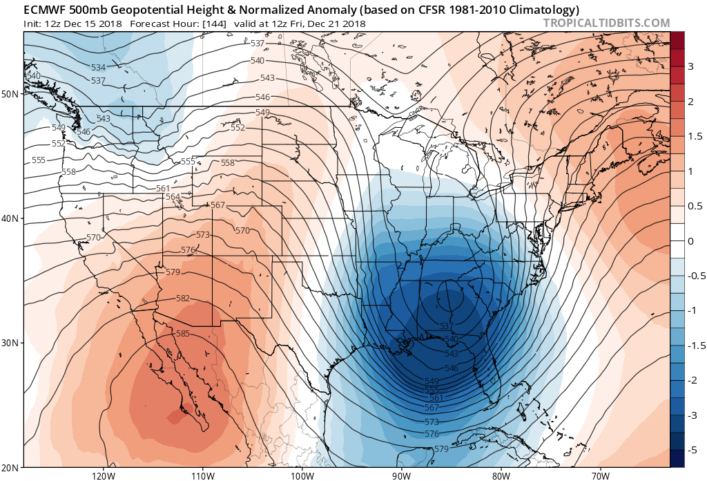
Posted: Sat Dec 15, 2018 2:35 pm
by gatorcane
Look at that trough for next weekend in today’s ECMWF:
Re: Florida Weather
Posted: Sat Dec 15, 2018 6:10 pm
by NDG
Though the El Nino has not been officially declared the pattern is very El Ninosh right now through at least the next 10 days, stormy at times across the deep south followed by below average temps while the northern US is enjoying a fairly mild wx pattern.
I was in Chicago this week, not that cold at all considering is mid December with all the snow on the ground gone, completely different to a year ago.
Re: Florida Weather
Posted: Sat Dec 15, 2018 6:20 pm
by AdamFirst
GFS and EURO seem to be in agreement for a stormy day late next week, Thursday into Friday, followed by another cooldown.
Re: Florida Weather
Posted: Sat Dec 15, 2018 7:53 pm
by psyclone
It's balmy across the north with above freezing highs in places like the Dakotas and MN so we're pretty much exempt from extreme cold threats until winter sets in up there. Looks like a few days of pretty nice weather is on tap with temps pretty close to normal.
Re: Florida Weather
Posted: Sun Dec 16, 2018 12:10 pm
by SFLcane
This next storm system for late next week looks it could provide a decent rain event across SFL we shall see but it looks potent.
Re: Florida Weather
Posted: Sun Dec 16, 2018 2:21 pm
by FlaWeatherDude
unlike this current trough, this looks to have connections to a cold air source from the north. Looks like we warm up by Xmas though.
Re: Florida Weather
Posted: Sun Dec 16, 2018 2:57 pm
by psyclone
SFLcane wrote:This next storm system for late next week looks it could provide a decent rain event across SFL we shall see but it looks potent.
There's signifcant QPF depicted statewide with a max on the southwest coast between Ft Myers and Tampa Bay. Would not be shocked if some SVR risk eventually evolves with this one too. What a pattern we are in..
Re: Florida Weather
Posted: Sun Dec 16, 2018 3:06 pm
by gatorcane
SFLcane wrote:This next storm system for late next week looks it could provide a decent rain event across SFL we shall see but it looks potent.
Yep looks more promising. That said much of metro South Florida got some decent rainfall somehow yesterday (despite only a 30% rain chance) enough to not have to turn on the sprinklers


Re: Florida Weather
Posted: Mon Dec 17, 2018 8:19 am
by AdamFirst
SPC has Thursday in its sights for here

...DISCUSSION...
Late-evening model guidance continues to suggest a substantial
deepening of an eastern US trough during the latter half of the
week. Significant height falls are forecast across the Gulf basin
Thursday as a strong 500mb speed max rotates into and through the
base of the trough before translating across the FL Peninsula. As a
result, high-PW air mass should advance northward ahead of this
feature and substantial instability appears likely to evolve across
the southern FL Peninsula prior to a strong cold frontal passage.
Given that strong shear will overspread this region, organized
severe convection appears possible, especially if buoyancy can
return to FL as currently forecast.
Re: Florida Weather
Posted: Mon Dec 17, 2018 10:54 am
by SFLcane

Subject: NWS Miami: Potential Severe Weather Thursday Dec 20.
Reply-To: "sr-mfl.ops@noaa.gov" <sr-mfl.ops@noaa.gov>
Good Morning Partners,
There is increasing confidence and potential for strong to severe thunderstorms across South Florida this Thursday ahead of a strong cold front associated with a low pressure system forecast to move through the region. Potential impacts include the potential for heavy rainfall, strong gusty winds and an isolated tornado is possible.
We are still several days out from the event and details may change as we approach Thursday. We will continue to provide briefings to update timing, impacts and forecast rainfall amounts.
Thanks!
Larry Kelly
Meteorologist
National Weather Service
Miami-South Florida
Re: Florida Weather
Posted: Mon Dec 17, 2018 12:06 pm
by floridasun78
how do cold air look behind this front on thur?
Re: Florida Weather
Posted: Mon Dec 17, 2018 12:24 pm
by northjaxpro

This air mass coming in with this upcoming front late week is not from arctic origins. The arctic air remains bottled up in Siberia. The southern jet stream remains dominant. feature. It is amplifying again with this next cold core UpperLow /shortwave late week as the progressive El Nino-ish pattern continues to roll right along.
Temps will drop to only be at or just slightly below average. Temps for Saturday morning here only forecast for now to drop into the upper 30s colder interior locales. The guidance is not forecasting a freeze here in North Florida as of this morning's guidance.
The preliminary guidance. is calling for upper 40s to near 50 most locales across Central Florida and 50s interior South Florida by Saturday morning.
Subtle changes to this with regards to temps as the week progresses, but I anticipate nothing drastic at this time.
Re: Florida Weather
Posted: Mon Dec 17, 2018 12:43 pm
by SFLcane
northjaxpro wrote::uarrow: This air mass coming in with this upcoming front late week is not from arctic origions. The arctic air remains bottled up in Siberia. The southern jet stream remains dominant aand is amplifying again with this next shortwave late week as the progressive El Nino-ish pattern continues to roll right along. Temps will drop to only be at or just slightly below average. Temps for Saturday morning here only forecast for now to drop into the upper 30s colder interior locales. The guidance is not forecasting a freeze here in North Florida as of this morning's guidance.
The preliminary guidance. is calling for upper 40s to near 50 most locales across Central Florida and 50s interior South Florida by Saturday morning.
Subtle changes to this as the week progresses, but I anticipate nothing drastic
The headlines of this system will not be the cold but the severe weather which is looking likely across portions of SFL late this weekend. Even some tornadoes
Re: Florida Weather
Posted: Mon Dec 17, 2018 12:50 pm
by northjaxpro
I know and am well aware of the severe potential down your way by Friday. We have had plenty of rain and even severe weather at times up here in Jax with this active pattern. I was just responding to floridasun's post about how cold will it be in the wake of this system.
Well. it looks like it finally will be your turn all down in South Florida for potential severe weather and heavy rain. Good. We have had more than enough of that up here. I definitely am not wanting any severe weather to occur of course.
Re: Florida Weather
Posted: Mon Dec 17, 2018 1:19 pm
by psyclone
This is going to be an energetic system. In addition to another round of heavy rain (WPC continues to spread the wealth around but focuses the heaviest rain on the western half of the peninsula from Cedar Key to Ft Myers) and severe potential...look at the gradient wind expected. The marine forecasts in the Gulf are wicked nasty with 12'+ seas already depicted in the nearshore leg off west central florida on Friday. This is going to be a spicy one.
Re: Florida Weather
Posted: Mon Dec 17, 2018 1:25 pm
by northjaxpro
Yeah I saw that psyclone. This is another dynamical, potent system coming in for Friday. The wind gradient indeed looks impressive and some real good waves look to get generated up across Apalachee Bay . It really looks to be quite an interesting day over in Cedar Key on Friday. I will be monitoring that closely.