Florida Weather

U.S. & Caribbean Weather Discussions and Severe Weather Events

Moderator: S2k Moderators

Forum rules

The posts in this forum are NOT official forecast and should not be used as such. They are just the opinion of the poster and may or may not be backed by sound meteorological data. They are NOT endorsed by any professional institution or STORM2K.

Help Support Storm2K
Message
Author
User avatar
SFLcane
S2K Supporter
S2K Supporter
Posts: 9627
Age: 46
Joined: Sat Jun 05, 2010 1:44 pm
Location: Lake Worth Florida

Re: Florida Weather

#13421 Postby SFLcane » Mon Dec 17, 2018 1:31 pm

northjaxpro wrote::uarrow: I know and am well aware of the severe potential down your way by Friday. We have had plenty of rain and even severe weather at times up here in Jax with this active pattern. I was just responding to floridasun's post about how cold will it be in the wake of this system.

Well. it looks like it finally will be your turn all down in South Florida for potential severe weather and heavy rain. Good. We have had more than enough of that up here. I definitely am not wanting any severe weather to occur of course.


Could get squally...bring it on!! :rain:
0 likes   

Patrick99
Category 5
Category 5
Posts: 1761
Joined: Mon May 24, 2004 3:43 pm
Location: Miami, FL

Re: Florida Weather

#13422 Postby Patrick99 » Mon Dec 17, 2018 4:26 pm

I'd like to see some severe storms....I won't get my hopes up though. Been burned too many times by "better dynamics further north and offshore." I'd take some thunder, period. It seems to be pretty rare to get a good squall line into Miami during the winter months.
0 likes   

User avatar
AdamFirst
S2K Supporter
S2K Supporter
Posts: 2488
Age: 35
Joined: Thu Aug 14, 2008 10:54 am
Location: Port Saint Lucie, FL

Re: Florida Weather

#13423 Postby AdamFirst » Mon Dec 17, 2018 9:04 pm

NWS Melbourne disco

Tue night-Thu...This period will start with a high pressure over mid-
Atlantic states, stretching towards the southeast US and Florida,
keeping fair weather conditions through the night. Light winds from
the N to NNE will turn over waters from the E as the high shifts
east. Lows will range from the mid 40s to near 50 for north of I-4
and interior areas while across the Space and Treasure Coast temps
will drop to the mid to upper 50s. Wed morning could start as a nice
day, with high clouds and light winds from the east.

As Wed progresses, the high will reach the western Atlantic waters
and a multi-layer trough will deepen as it moves towards the central
US. This trough will dig south from Canada towards the western Gulf
of Mexico with a surface low developing late Wed into Thu night over
eastern Texas. Locally, the pressure gradient will feel the
approaching low and it will increase locally, causing for winds to
start picking up Wed night. A warm front will also move north across
FL, bringing moisture towards the FL peninsula from the Gulf, and
instability will start to increase over the local area. The weather
pattern will be complex for FL, as the low pressure moves towards
the southeast US on Thursday. The Storm Prediction Center already
has our area under a 15% chance of risk of severe weather on Day 4,
which is uncommon to have this level of confidence this far in
time. But the main global models (ie GFS and Euro) have been
consistent in their solution and close to each other. The forecast
is already high for the Wed night and Thu period, with POPs of
60-70% and 90% respectively and chance for thunderstorms. Based
on the current forecast, strong to damaging winds, heavy rain and
tornadoes will be possible for east central Florida, mainly on
Thursday. As the day gets closer, a better timing for these
impacts will be provided.
1 likes   
Dolphins Marlins Canes Golden Panthers HEAT
Andrew 1992 - Irene 1999 - Frances 2004 - Jeanne 2004 - Wilma 2005 - Fay 2008 - Isaac 2012 - Matthew 2016 - Irma 2017 - Dorian 2019 - Ian 2022 - Nicole 2022

User avatar
gatorcane
S2K Supporter
S2K Supporter
Posts: 23499
Age: 46
Joined: Sun Mar 13, 2005 3:54 pm
Location: Boca Raton, FL

Re: Florida Weather

#13424 Postby gatorcane » Mon Dec 17, 2018 10:12 pm

This system looks potent for sure. The question is just how far south the best dynamics make it. Looks like the GFS has the strongest squalls down to Lake O area but not really down into metro SE Florida. I could see this outcome with the strongest storms over SW and South-Central Florida and up into Central Florida but not quite making it down to into deep South Florida. Nonetheless this system could bring the highest rain totals we have seen in a while here with a decent squal line pushing through and the wind profile looks impressive with the NWS forecasting 36mph wind gusts in Boca Raton on Friday.
1 likes   

User avatar
northjaxpro
S2K Supporter
S2K Supporter
Posts: 8900
Joined: Mon Sep 27, 2010 11:21 am
Location: Jacksonville, FL

Re: Florida Weather

#13425 Postby northjaxpro » Mon Dec 17, 2018 10:18 pm

Significant weather and even severe weather looks more more a certainty for South Florida on Thursday.afternoon amd evening. Also, could see some into Friday morning as well just ahead of this dynamic sysyem.

A very impressive, dynamic southern stream shortwave will impact the entire peninsula Thursday-Friday evening.The latest GFS has 500mb heights as low as 540 down into the Northeast GOM by Thursday evening.. That is quite an extremely deep, core core Upper shortwave! The pressure gradient with this system is going to be .really something. The wind looks to be well above galet o storm force across the Gulf of Mexico. Wind looks to gust up to 30mph + across much of peninsula, especially Thursday night into Friday.
1 likes   
NEVER, EVER SAY NEVER in the tropics and weather in general, and most importantly, with life itself!!

________________________________________________________________________________________

Fay 2008 Beryl 2012 Debby 2012 Colin 2016 Hermine 2016 Julia 2016 Matthew 2016 Irma 2017 Dorian 2019

psyclone
S2K Supporter
S2K Supporter
Posts: 4510
Joined: Wed Aug 24, 2005 9:04 pm
Location: palm harbor fl

Re: Florida Weather

#13426 Postby psyclone » Mon Dec 17, 2018 10:50 pm

I would not be shocked if some coastal flooding hazard/beach erosion issues take place on the west coast with strong onshore winds and big swells. This is going to be a multifaceted event with severe potential/heavy rain and flood potential and coastal water action. a noteworthy cold season event is certainly possible depending on how this evolves. It definitely has my interest...as does the prospects of nice weather as we head toward Christmas...and a hopefully delightfully warm and dry pattern thereafter.
1 likes   

User avatar
TheStormExpert
Category 5
Category 5
Posts: 8487
Age: 30
Joined: Wed Feb 16, 2011 5:38 pm
Location: Palm Beach Gardens, FL

Re: Florida Weather

#13427 Postby TheStormExpert » Tue Dec 18, 2018 8:29 am

We're lucking out that there will be little to no snowpack up north with this upcoming storm system and front as that would have likely allowed temperatures to tumble into the 30's into S.FL.

As for the storm system it looks as if the highest rainfall totals will be centered from a line near Fort Myers to the Treasure Coast going by the GFS, and from a line just north of Tampa along the Big Bend region to Jacksonville if you go by the Euro. It'll be interesting to see what we manage to get her in S.FL as the Miami NWS Offices' forecast discussion is calling for the best dynamics to be further south than the previous two fronts leading to the threat for straight-line wind and tornado activity on Thursday afternoon into the overnight hours. There will also be a rare minor risk of Extratropical Surge along the Gulf
coast Thursday and Friday.

Enjoy the cooler weather as that will likely be the last front to pass through the region for the rest of 2018! Looks like we will begin to torch after Christmas for the foreseeable future.
1 likes   
The following post is NOT an official forecast and should not be used as such. It is just the opinion of the poster and may or may not be backed by sound meteorological data. It is NOT endorsed by storm2k.org.

User avatar
SFLcane
S2K Supporter
S2K Supporter
Posts: 9627
Age: 46
Joined: Sat Jun 05, 2010 1:44 pm
Location: Lake Worth Florida

Re: Florida Weather

#13428 Postby SFLcane » Tue Dec 18, 2018 8:41 am

Its gonna blow SFL...55 kt 850 mb thu 23z / by gfs 06Z ! I would not be surprised to see some gusts to 40 mph across the mainland

Image
1 likes   

User avatar
SFLcane
S2K Supporter
S2K Supporter
Posts: 9627
Age: 46
Joined: Sat Jun 05, 2010 1:44 pm
Location: Lake Worth Florida

Re: Florida Weather

#13429 Postby SFLcane » Tue Dec 18, 2018 8:46 am

SPC...

Strong mid-level flow is forecast to dig southeast across TX into
the southern Gulf basin during the day3 period. This process will
ensure significant deepening of a larger trough that will translate
east across MS Valley into the southeastern US/eastern Gulf of
Mexico by Friday morning. As this trough evolves, low-mid level
trajectories will become increasingly favorable for higher theta-e
air mass to advance north across the Caribbean into the southern FL
Peninsula where near 70F surface dew points are likely to return.
This air-mass recovery is expected to aid significant convection
across the eastern Gulf basin early in the period along a pronounced
surface front where strong large-scale forcing for ascent will be
maximized. Very strong shear will develop across FL ahead of the
short wave which will encourage organized convection. Frontal
convection will likely be linear in nature, but embedded supercells
are expected. There is some concern that isolated pre-frontal
supercells may also develop within an increasing warm advection
regime over the Peninsula. If moisture/instability returns to FL as
currently forecast, all severe hazards may be noted with this
activity given the strength and geometry of this evolving trough.
1 likes   

Patrick99
Category 5
Category 5
Posts: 1761
Joined: Mon May 24, 2004 3:43 pm
Location: Miami, FL

Re: Florida Weather

#13430 Postby Patrick99 » Tue Dec 18, 2018 9:07 am

Some interesting wording in NWS Miami's discussion this morning. They mention that dynamics and instability may actually get far enough south to give us a real shot at a severe squall line. I'll believe it when I see it, but they seem more confident than the usual lukewarm "chance of thunderstorms" wording we often get with frontal passages.

Assuming all of this starts tomorrow with the warm front lifting northward as predicted, the weather is going to have to change quite a lot in a pretty short time frame to get there. A little chilly this AM, with a light drainage flow and clear skies. Just by looking outside, you certainly wouldn't think inclement weather is imminent within 36 hours.
1 likes   

User avatar
SFLcane
S2K Supporter
S2K Supporter
Posts: 9627
Age: 46
Joined: Sat Jun 05, 2010 1:44 pm
Location: Lake Worth Florida

Re: Florida Weather

#13431 Postby SFLcane » Tue Dec 18, 2018 9:12 am

GFS shows gust to 42-48 mph across the mainland...Its certainly all over the models so lets see if we get into a high wind advisory.
1 likes   

Patrick99
Category 5
Category 5
Posts: 1761
Joined: Mon May 24, 2004 3:43 pm
Location: Miami, FL

Re: Florida Weather

#13432 Postby Patrick99 » Tue Dec 18, 2018 11:02 am

SFLcane wrote:GFS shows gust to 42-48 mph across the mainland...Its certainly all over the models so lets see if we get into a high wind advisory.


Wow, with that kind of wind I might have to seriously consider bringing the chairs in off the balcony.
0 likes   

User avatar
gatorcane
S2K Supporter
S2K Supporter
Posts: 23499
Age: 46
Joined: Sun Mar 13, 2005 3:54 pm
Location: Boca Raton, FL

Re: Florida Weather

#13433 Postby gatorcane » Tue Dec 18, 2018 11:33 am

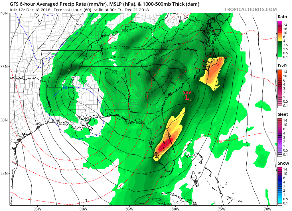
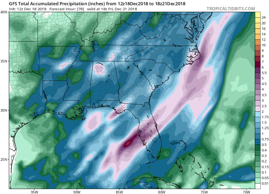
Best dynamics still look to be just north of metro SE florida over the Lake O region and down into Central/NW Palm Beach County perhaps and extending back into the Ft. Myers areas of SW Florida and up through Central Florida. Still looking like a solid squall line will swing through metro SE Florida including Broward and Miami-Dade with high wind gusts but from a severe weather perspective it looks like the focal point would be just to our north and west - too close for comfort this go around. We'll see as we get closer, 12Z GFS running now - interesting weather ahead for sure.

Update: 12Z GFS looks to have shifted the best dynamics a bit away from metro SE Florida, now no longer in Palm Beach county even, is this a trend or just one run?
Image
Image
0 likes   

User avatar
Bocadude85
Category 5
Category 5
Posts: 2941
Age: 37
Joined: Mon Apr 18, 2005 2:20 pm
Location: Honolulu,Hi

Re: Florida Weather

#13434 Postby Bocadude85 » Tue Dec 18, 2018 11:55 am

gatorcane wrote:Best dynamics still look to be just north of metro SE florida over the Lake O region and down into Central/NW Palm Beach County perhaps and extending back into the Ft. Myers areas of SW Florida and up through Central Florida. Still looking like a solid squall line will swing through metro SE Florida including Broward and Miami-Dade with high wind gusts but from a severe weather perspective it looks like the focal point would be just to our north and west - too close for comfort this go around. We'll see as we get closer, 12Z GFS running now - interesting weather ahead for sure.

Update: 12Z GFS looks to have shifted the best dynamics a bit away from metro SE Florida, now no longer in Palm Beach county even, is this a trend or just one run?
https://i.postimg.cc/wM9sQBcc/gfs-mslp-pcpn-frzn-seus-10.png
https://i.postimg.cc/8PRTVHG5/gfs-apcpn-seus-13.png


Im not so sure S. FL will escape the severe weather this time, a lot of past S.Fla tornado outbreaks had similar conditions as being forecast by the models, I’m thinking we are going to see discrete supercells forming out ahead of the main squall line over the SW coast/Everglades heading northeast towards the SE metro area.
Last edited by Bocadude85 on Tue Dec 18, 2018 12:23 pm, edited 1 time in total.
0 likes   

User avatar
chaser1
S2K Supporter
S2K Supporter
Posts: 4750
Age: 63
Joined: Sat Oct 15, 2005 5:59 pm
Location: Longwood, Fl

Re: Florida Weather

#13435 Postby chaser1 » Tue Dec 18, 2018 12:21 pm

Pretty impressive for a potent December full latitude squall line that most of Florida will feel the affects from. I'd guess that 40 mph gusts will be experienced in a good number of locals throughout South and Central Florida. I"d bet there's gonna be plenty of pesky small branch debris here in Central Florida, with so many Water Oaks that seem to succumb to heavy rain and wind. S.W. Coast from Cape Coral north to around Tampa sure seem poised to see some beach erosion between Thursday and Friday. Ft. Myers area looks to have their high tides late Wednesday night (1:00 Thursday a.m.) and again about 3:00 p.m. on Thursday. Tide and wave action could be impressive there.

No doubt there'll be Lake Wind Advisories over most of Florida, Gale Warnings for East and West Coast waters, W. Coast Flood Watchs/Warnings, Severe Storm Watches for at least 2/3 of the State, Tornado Watch boxes, and one or two Partridge in a Pear dislodgings LOL. I guess if I had to take my pick for this event's nastiest weather, i'd guess points between Ft. Myers/Sarasota and Ft. Lauderdale to Melbourne. Tornadoes? I think doubtful but then again that doesn't detract from the potential of a good deal of Straight Line Wind damage.

Regardless of this event not tapping into actual Arctic air, I'd guess that between the overcast conditions, backside low advection, and especially the wind.... Friday is gonna look and feel a lot like Winter for much of Florida. The strength of this southern stream system is pretty impressive. Certainly more common for Florida during El Nino type years. Makes me think that January and February are gonna really have a couple "duzzies" to look forward to. Bring the kids - fun for the whole family LOL!
1 likes   
Personal Forecast Disclaimer:
The posts in this forum are NOT official forecast and should not be used as such. They are just the opinion of the poster and may or may not be backed by sound meteorological data. They are NOT endorsed by any professional institution or storm2k.org. For official information, please refer to the NHC and NWS products.


User avatar
chaser1
S2K Supporter
S2K Supporter
Posts: 4750
Age: 63
Joined: Sat Oct 15, 2005 5:59 pm
Location: Longwood, Fl

Re: Florida Weather

#13436 Postby chaser1 » Tue Dec 18, 2018 12:41 pm

Bocadude85 wrote:
gatorcane wrote:Best dynamics still look to be just north of metro SE florida over the Lake O region and down into Central/NW Palm Beach County perhaps and extending back into the Ft. Myers areas of SW Florida and up through Central Florida. Still looking like a solid squall line will swing through metro SE Florida including Broward and Miami-Dade with high wind gusts but from a severe weather perspective it looks like the focal point would be just to our north and west - too close for comfort this go around. We'll see as we get closer, 12Z GFS running now - interesting weather ahead for sure.

Update: 12Z GFS looks to have shifted the best dynamics a bit away from metro SE Florida, now no longer in Palm Beach county even, is this a trend or just one run?
https://i.postimg.cc/wM9sQBcc/gfs-mslp-pcpn-frzn-seus-10.png
https://i.postimg.cc/8PRTVHG5/gfs-apcpn-seus-13.png


Im not so sure S. FL will escape the severe weather this time, a lot of past S.Fla tornado outbreaks had similar conditions as being forecast by the models, I’m thinking we are going to see discrete supercells forming over the SW coast/Everglades heading northeast towards the SE metro area.


I think you're right regarding the severe weather risk in S. Florida. The only thing I question is whether severe storm/wind impact will occur much anywhere away from the actual squall line itself. Just seems to me that the winds might not be backed enough (more east to southeast ahead of the front) to be a cause for low level convergence and the formation of discrete convective cells ahead of the squall line. Looks to me like there's such a deep southerly low to mid layer flow, that most/all severe weather would seem poised to occur in cells buzzing NNE along and within the squall line itself? Regardless whether straight line winds OR any breakout of tornadoes there sure seems to be a very real risk for damaging conditions.
0 likes   
Personal Forecast Disclaimer:
The posts in this forum are NOT official forecast and should not be used as such. They are just the opinion of the poster and may or may not be backed by sound meteorological data. They are NOT endorsed by any professional institution or storm2k.org. For official information, please refer to the NHC and NWS products.


User avatar
SFLcane
S2K Supporter
S2K Supporter
Posts: 9627
Age: 46
Joined: Sat Jun 05, 2010 1:44 pm
Location: Lake Worth Florida

Re: Florida Weather

#13437 Postby SFLcane » Tue Dec 18, 2018 12:45 pm

Impressive wind fields across SFL.. Definitely a severe wx threat. It will be windy Thursday, but maybe even windier Friday as dry air tries to mix down stronger winds aloft.
0 likes   

User avatar
chaser1
S2K Supporter
S2K Supporter
Posts: 4750
Age: 63
Joined: Sat Oct 15, 2005 5:59 pm
Location: Longwood, Fl

Re: Florida Weather

#13438 Postby chaser1 » Tue Dec 18, 2018 1:25 pm

SFLcane wrote:Impressive wind fields across SFL.. Definitely a severe wx threat. It will be windy Thursday, but maybe even windier Friday as dry air tries to mix down stronger winds aloft.


If it weren't for my wanting to stay put and watch conditions unfold here in the Orlando area, i'd sure love to be on the coast around Venice to watch the surf and squalls move in! Those strong winds and crazy surf would sure make for some fun shell and sharks tooth hunting. Hard to guess exactly where the worst weather will occur but if I were offered a free $100 bet on any ONE SPOT for a tornadic risk this Thursday, I suppose I'd go with Sebring, Fl. at 7:05 p.m.
0 likes   
Personal Forecast Disclaimer:
The posts in this forum are NOT official forecast and should not be used as such. They are just the opinion of the poster and may or may not be backed by sound meteorological data. They are NOT endorsed by any professional institution or storm2k.org. For official information, please refer to the NHC and NWS products.


User avatar
SFLcane
S2K Supporter
S2K Supporter
Posts: 9627
Age: 46
Joined: Sat Jun 05, 2010 1:44 pm
Location: Lake Worth Florida

Re: Florida Weather

#13439 Postby SFLcane » Tue Dec 18, 2018 3:01 pm

Are we going through a tropical storm or what is going on here? :eek: :roll:

Image
0 likes   

User avatar
FlaWeatherDude
Tropical Storm
Tropical Storm
Posts: 110
Age: 39
Joined: Wed Oct 10, 2018 2:57 pm
Location: Orlando, FL.

Re: Florida Weather

#13440 Postby FlaWeatherDude » Tue Dec 18, 2018 3:15 pm

After a chilly weekend(21-23) it looks likey Christmas is shaping up to be nice with low humidity but by next Thusday or so we torch(though that might change). I hope there will be intense lightning with loud-cracking thunder widespread with this storm system. Looks more promising then the previous one's.
0 likes   
"Windy has wings to fly above the clouds".


Return to “USA & Caribbean Weather”

Who is online

Users browsing this forum: No registered users and 30 guests