Page 692 of 883
Re: Florida Weather
Posted: Sun Jan 13, 2019 1:44 am
by chaser1
boca wrote:00z GFS has also backed off on the cold.In the back of my mouth and I thought this was too good too be true.
I see zero evidence of this. Are we looking at the same 500 mb and surface forcast charts?? If you're looking at the Thermodynamic 2m temp forecast maps, I'd suggest you not use that to guage accurate long range temperature assessment. You have to focus on the forecast synoptics depicting the depth of long wave pattern, directional flow and dropping mid level heights, as well as origin, strength, gradient, and orientation of surface flow. Everything I'm seeing within tonight's 0 Z model data simply suggests VERY cold conditions advecting southward throughout Florida beginning on or around Jan 20th, with what would presently appear to be even colder conditions in the days to follow.
Re: Florida Weather
Posted: Sun Jan 13, 2019 2:14 am
by chaser1
boca wrote:chaser1 wrote:Run after run model analysis is seriously reinforcing my consideration to actually break down and buy an ice scraper for my windshield

I’m going to need an ice scrapper going to New York on Jan 24th for a week that’s shows -8.
But you're right on about needing an ice scraper in New York at that time! BTW, the last time N.Y.C. saw -5 ° or colder.... was in 1943. I believe New York City only experienced 3 occassions where temps dropped below zero during the past 30 years, and that their all time coldest official temp, was -15° in Feb. 1934.
I'm fairly confident that New York will experience below 0 ° temps by month end. Right now, it appears that same air mass will be ushered southward affecting the entire S.E. CONUS.
Re: Florida Weather
Posted: Sun Jan 13, 2019 2:32 am
by chaser1
Fact remains however, is that Psyclone is right. Read the tea leaves, anticipate the possibilities, but until about 4-5 days out.... the only certainty is still "death and taxes"

Re: Florida Weather
Posted: Sun Jan 13, 2019 5:21 am
by boca
chaser1 wrote:boca wrote:00z GFS has also backed off on the cold.In the back of my mouth and I thought this was too good too be true.
I see zero evidence of this. Are we looking at the same 500 mb and surface forcast charts?? If you're looking at the Thermodynamic 2m temp forecast maps, I'd suggest you not use that to guage accurate long range temperature assessment. You have to focus on the forecast synoptics depicting the depth of long wave pattern, directional flow and dropping mid level heights, as well as origin, strength, gradient, and orientation of surface flow. Everything I'm seeing within tonight's 0 Z model data simply suggests VERY cold conditions advecting southward throughout Florida beginning on or around Jan 20th, with what would presently appear to be even colder conditions in the days to follow.
I was looking at the thermodynamic 2m temp map and I saw a difference in the temps from the GFS 12z map I saw earlier,and I probably misread the run.
Re: Florida Weather
Posted: Sun Jan 13, 2019 8:28 am
by SFLcane
Boca is correct looking at this mornings models most of the real cold air bypasses extreme sfl but then again what’s new.
Re: Florida Weather
Posted: Sun Jan 13, 2019 8:43 am
by boca
The new GFS FV3 model brings the temps down into the 40s down here and that’s cold but not extreme.I don’t see that extreme cold air up in Canada going straight south and looking at the NAO it’s mostly neutral not negative.if northjaxpro or chaser1 can enlighten me I welcome the feedback.
Re: Florida Weather
Posted: Sun Jan 13, 2019 10:15 am
by NDG
FL needs to watch out for the 1040+mb Arctic High forecasted by models to come from the Arctic down the Central US & Eastern US. The good news so far is that models show the core & center of it staying to the north of the Peninsula probably because of the near to slight positive NAO pattern. Just something to keep our eyes on over the next few days with the latest GFS showing lows in the 30s across central FL Monday morning but the Euro is slower with the passage of the front showing also low temps in the 30s across central FL but for Tuesday morning. In the meantime enjoy the nice, mild comfortable wx through the next 6-7 days.
Re: Florida Weather
Posted: Sun Jan 13, 2019 10:25 am
by northjaxpro
Ah patience Boca. One thing about this science you learn through experience is to learn the nuiances and daily fluctuations of weather, especially a major large scale pattern change such as this one we are now in the midst .
The thing you have to keep in perspective is the entire big picture. There are so many moving, critical components which will determine the extent and magnitude of the cold pattern over the next several weeks.
1. First, the establishment of the Polar Vortex has yet to be completed. It will be around the end of this month for this to be completed. It is forecast to be in position near Hudson Bay
2. The model ensembles are in very good consensus that 500 mb ridging will be quite evident across the Pacific/Western Canada/ Alaska and impressive ridging over Greenland by the end of this month. The models, if they are right about the 500 mb pattern, should yield to a +PNA, -AO and -NAO teleconnections by the start of February. The ridging I am seeing in the long range across Greenland usually always a solid harbinger of a very good -negative NAO . I would be very surprised if this would not materialize, especially given the indicators in the pattern shift now.
3. Expect models in the 5 -10 day range to change with this large massive pattern shift because it is very progressive . Remember, forecasting the timing of these massive Arctic Highs. and these shortwaves/disturbances always, always are very challenging. It is the same for these models in the short to medium term.
4. Once the PV is firmly established, it will be like a running engine. The Constant counter/clockwise rotation of vorticies energy southward will be locked into place for who knows how long? It will be cold air dump after another, recharge and reload. The best analogs to use is 1977-78 winter, when the massive cold pattern lasted up 45 days before finally breaking down. I am not saying this is how this current pattern will fare. However, the potential for this to happen is definitely there.
Just elaboring a bit more. I am trying to keep this all in simplier layman' s terms overall. This is only just a little of what to watch for. I did not even get further into the possible southern stream and polar jet interactions during these next few weeks. I have already discussed this in earlier posts here and on the Deep South and Texas threads. So much to discuss and watch in the coming days. This is why I love this business and enjoy discussing it on my spare time as a member of this fantastic site for over eight years now.
Re: Florida Weather
Posted: Sun Jan 13, 2019 10:54 am
by TheStormExpert
I’d believe all this chatter of cold for the peninsula of Florida on the models if we had a sustained -NAO.
Re: Florida Weather
Posted: Sun Jan 13, 2019 11:09 am
by boca
I check out the NAO page everyday to look for the forecast dip and it doesn’t happen now according to northjaxpro who knows a heck of a lot more than me says it will go negative towards the end of the month so I’m being patient. The other aspect is we haven’t had any rain really at all down here and I think it’s only really rained twice since September and people say it rained but that’s just a couple of minutes on the car windshield which doesn’t count.
Re: Florida Weather
Posted: Sun Jan 13, 2019 11:19 am
by northjaxpro

We talk about it all the time. It is just about at the point where I can understand people having the need to actually see it to believe it rationale about the - NAO for all of us here in Florida.
It has been a long long time since we have seen a true negative NAO in the heart of winter. 2009-10 winter was the last solid one to impact the peninsula.
Re: Florida Weather
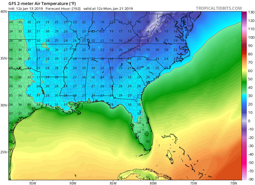
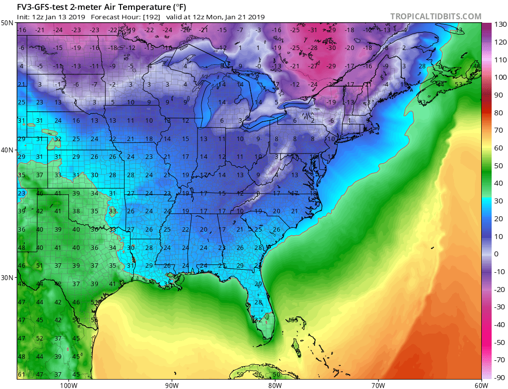
Posted: Sun Jan 13, 2019 1:16 pm
by gatorcane
Last three GFS have gone colder each run for the front just over a week from now. Also the FV3 GFS has gone MUCH colder with a freeze down to Ft. Myers. Latest 12Z runs:
Re: Florida Weather
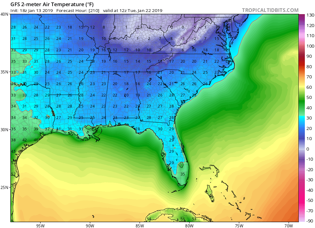
Posted: Sun Jan 13, 2019 6:34 pm
by gatorcane
Ouch...GFS MUCH colder on the 18Z run. No doubt Florida needs to watch this closely. Still 210 hours out:

Re: Florida Weather
Posted: Sun Jan 13, 2019 10:35 pm
by TheStormExpert
Happy hour GFS living up to its name even outside of hurricane season?
Re: Florida Weather
Posted: Mon Jan 14, 2019 1:03 am
by chaser1
Not unlike our wary eyes surveilling and comparing potential tropical development on each new model run, gaging run after run consistancy, and judging possible tracks and intensity of tropical cyclones during the Hurricane Season; All the while when present analysis and satellite depict no indication of the hotly debated event which has yet to occur.
Anticipating large scale weather changes is an ebb and flow process full of fluctuation. We can all bantor about our favorite long range prediction tool, map, or forecast but in the end those details are unrealized conjecture. Stepping back and watching broad forecast trends however, should at minimum enlighten each of us to the range of reasonable impact that could occr.
Re: Florida Weather
Posted: Mon Jan 14, 2019 7:15 am
by NDG
Is looking more and more likely that a very cold Arctic High is coming down in less than 7 days with a chance of light freezing temps all the way down to the I-4 corridor, depending on timing and trajectory of the Arctic High. There's still some timing difference between the Euro and latest 06z GFS but coming in together better with the Euro showing the coldest morning for parts of west central FL Tuesday morning while the GFS shows it for Monday morning. The saving grace for east central and southern FL is that the Arctic Center will stay to the north of Peninsula so winds at H925 will switch off of the Atlantic as soon as Monday night modifying the temps along the east coast.
Re: Florida Weather
Posted: Mon Jan 14, 2019 7:32 am
by SFLcane
NDG wrote:Is looking more and more likely that a very cold Arctic High is coming down in less than 7 days with a chance of light freezing temps all the way down to the I-4 corridor, depending on timing and trajectory of the Arctic High. There's still some timing difference between the Euro and latest 06z GFS but coming in together better with the Euro showing the coldest morning for parts of west central FL Tuesday morning while the GFS shows it for Monday morning. The saving grace for east central and southern FL is that the Arctic Center will stay to the north of Peninsula so winds at H925 will switch off of the Atlantic as soon as Monday night modifying the temps along the east coast.
Of course there’s a saving grace we will probably have some 50’s no big deal..
Re: Florida Weather
Posted: Mon Jan 14, 2019 7:43 am
by boca
Yeah the cold fronts we get the winds are already off the Atlantic so we never get 30s and once in a while 40s but 50s seem to be the norm down here.Lets see if the pattern changes will affect us or we be too far south to benefit.
Re: Florida Weather
Posted: Mon Jan 14, 2019 7:47 am
by psyclone
So far it's not looking like anything out of the ordinary...Just standard winter chill
Re: Florida Weather
Posted: Mon Jan 14, 2019 12:06 pm
by boca
Looks like ordinary cool fronts nothing crazy.