Page 700 of 883
Re: Florida Weather
Posted: Tue Jan 22, 2019 2:04 pm
by psyclone
The Euro beyond 5 days has really struggled as of late.
Re: Florida Weather
Posted: Tue Jan 22, 2019 3:23 pm
by northjaxpro

It has been extremely poor lately.
Re: Florida Weather
Posted: Wed Jan 23, 2019 1:37 am
by chaser1
That spread of solutions IS rather remarkable. Honestly, I think the GFS has actually been more consistant for it's mid range forecasts in recent weeks.
Re: Florida Weather
Posted: Wed Jan 23, 2019 4:18 am
by FireRat
I posted this on the deep south winter thread as well a few days ago, this could give a hint of what may be to come...looks very interesting next month according to the weather channel:
According to the Weather Channel, February will very likely be far below average, resulting in prolonged bitterly cold conditions in the Eastern US. I don't think I've ever seen a forecast that below average for the southeast before, have a look!...
https://weather.com/forecast/national/news/2019-01-16-february-march-april-2019-us-temperature-outlook-weather-company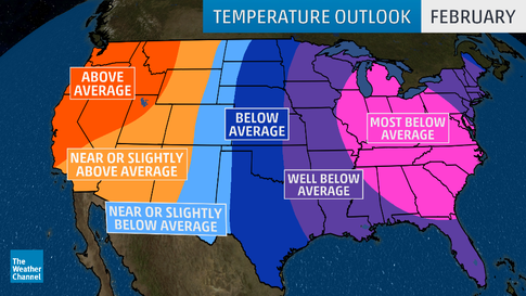
You guys down in FL should keep a wary eye next month, they've been saying Feb would be the coldest winter month this year for a while now, and their graphic sure has crazy colors, could this support even more that idea about the NAO going down big time soon? When have we ever seen "well below average" and even "most below avg" in these parts before? that sure got my attention, they smell something!

Re: Florida Weather
Posted: Wed Jan 23, 2019 7:01 am
by Tampa Bay Hurricane
Strong to Severe thunderstorms possible tonight with 850 mb winds of 60 to 80 knots over much of the northern and central peninsula. SPC has us in a marginal risk.
http://www.spc.noaa.gov
Re: Florida Weather
Posted: Wed Jan 23, 2019 7:50 am
by northjaxpro
FireRat wrote:I posted this on the deep south winter thread as well a few days ago, this could give a hint of what may be to come...looks very interesting next month according to the weather channel:
According to the Weather Channel, February will very likely be far below average, resulting in prolonged bitterly cold conditions in the Eastern US. I don't think I've ever seen a forecast that below average for the southeast before, have a look!...
You guys down in FL should keep a wary eye next month, they've been saying Feb would be the coldest winter month this year for a while now, and their graphic sure has crazy colors, could this support even more that idea about the NAO going down big time soon? When have we ever seen "well below average" and even "most below avg" in these parts before? that sure got my attention, they smell something!
We shall see Firerat. I was expecting to see all this taking place right about right now into the start of February with the MJO apex/ SSWE. It has not aligned right just yet with the teleconnections indices across the Florida peninsula of bringing much colder weather our way. Negative NAO just has not kicked into effect yet. Mother Nature has a mind of her own of course.
We will see what lies ahead later in February.
Re: Florida Weather
Posted: Wed Jan 23, 2019 7:59 am
by northjaxpro
Tampa Bay Hurricane wrote:Strong to Severe thunderstorms possible tonight with 850 mb winds of 60 to 80 knots over much of the northern and central peninsula. SPC has us in a marginal risk.
http://www.spc.noaa.gov
Yeah, I will be watching this closely late tonight across the northern peninsula. We have another southern stream shortwave pivoting through the Deep South. We could see some possible severe thunderstorms as dynamics look rather respectable for strong straight line winds and hail.
Hopefully, we will not see any tornadic activity in the region, like they had last weekend across Central Alabama.
Re: Florida Weather
Posted: Wed Jan 23, 2019 2:48 pm
by Lagreeneyes03
northjaxpro wrote:FireRat wrote:I posted this on the deep south winter thread as well a few days ago, this could give a hint of what may be to come...looks very interesting next month according to the weather channel:
According to the Weather Channel, February will very likely be far below average, resulting in prolonged bitterly cold conditions in the Eastern US. I don't think I've ever seen a forecast that below average for the southeast before, have a look!...
You guys down in FL should keep a wary eye next month, they've been saying Feb would be the coldest winter month this year for a while now, and their graphic sure has crazy colors, could this support even more that idea about the NAO going down big time soon? When have we ever seen "well below average" and even "most below avg" in these parts before? that sure got my attention, they smell something!
We shall see Firerat. I was expecting to see all this taking place right about right now into the start of February with the MJO apex/ SSWE. It has not aligned right just yet with the teleconnections indices across the Florida peninsula of bringing much colder weather our way. Negative NAO just has not kicked into effect yet. Mother Nature has a mind of her own of course.
We will see what lies ahead later in February.
What will it mean if the NAO doesn't go Negative? Warmer weather? I''m normally in the Texas pages, but as I"m coming to Florida for the Daytona 500 next month, I was hoping for warm, sunshine like it's been the past few years when I've come for it. Praying it doesn't get cold, that's what I'm trying to escape!
Re: Florida Weather
Posted: Wed Jan 23, 2019 3:13 pm
by northjaxpro
A bit too soon to nail down how it will be in Daytona in mid-February. However, if our extreme luck with escaping the - NAO keeps up, the core of the harsh, bitter cold will remain to our north as the Arctic High Pressure domes would not drop south, but move eastward toward either New England or the Mid- Atlantic regions. The NAO has to go into a negative index to drive very cold air southward down into the peninsula.
You may get lucky with a type of day we are having today that weekend in Daytona coming up. We have partly cloudy conditions with temps in the 70s. It is beautiful today here in Jax, like a day in the middle of spring. That is how it has been in recent years down this way as we have been extremely lucky escaping harsh cold. I have only measured just 3 freezes at my home ob in Northeast Florida thus far this Fall/Winter 2018-2019 season. We have had above normal Fall/Winters here, especially since 2015.
We can get colder anomalies with a -AO, +PNA without a - NAO, like we had in late Dec 2017 and early January 2018. But, without a - NAO, Florida generally escapes extreme, anomalous cold, like what is going on currently across the Great Lakes, Midwest and into New England.
Re: Florida Weather
Posted: Wed Jan 23, 2019 4:00 pm
by FireRat
Very true indeed, the NAO has to go negative for FL to get extreme cold. It seems very hard to predict when the NAO will go negative, and usually it's either positive or neutral. Lets see if it tries to go negative in coming weeks.
Re: Florida Weather
Posted: Wed Jan 23, 2019 11:47 pm
by Tampa Bay Hurricane
Pretty impressive Squall line with cold cloud tops and lots of lighting out over the eastern gulf approaching the peninsula.
https://photos.app.goo.gl/sSpGggVU1u7ZbpP89
Re: Florida Weather
Posted: Wed Jan 23, 2019 11:56 pm
by psyclone
I've been watching the squall line with increasing interest. Lightning has been much more feisty over the gulf as compared to the panhandle regions (which were designated slight risk areas earlier today). It will be interesting if it maintains as it approaches land. Overall thunderstorm activity has been more resilient this winter on approach to land from the gulf. Too bad the time of day for arrival...is lousy. Looks like an extended period of much below temps is on the way after this dose of convection. I like winter squall lines much more than chilly weather...
Re: Florida Weather
Posted: Thu Jan 24, 2019 12:43 am
by FlaWeatherDude
Much more lightning then with previous squallines!
Re: Florida Weather
Posted: Thu Jan 24, 2019 3:53 am
by Tampa Bay Hurricane
Winds gusting to 40 mph at st. Pete Clearwater airport
https://forecast.weather.gov/MapClick.p ... El86rpOnDsSustained winds of 25 to 30 mph area wide.
Re: Florida Weather
Posted: Thu Jan 24, 2019 5:06 am
by psyclone
Just experienced a couple minutes of near white out conditions and strong winds with the squall line.
Re: Florida Weather
Posted: Thu Jan 24, 2019 5:33 am
by Tampa Bay Hurricane
54 MPH wind gust with severe storm at St. Petersburg Albert Whitted Aitport Downtown. Tons of lightning too!
https://photos.app.goo.gl/61iF4UXpWPUKCymX9
Re: Florida Weather
Posted: Thu Jan 24, 2019 5:48 am
by northjaxpro
We are getting hammered here in Jax cutrently. Receiving heavy down pours and wind gusted to 33mph recently There has been no severe weather so far early this morning.
Squall line has held up well all night, which shows how impressive the dynamics are with this shortwave.
As Psyclone mentioned a little earlier, we have a prolonged period of below normal, colder weather on the way this weekend, and into next week. Cool High Pressure. (1028 mb by Saturday evening) dome will build into the Deep South in the aftermath of this shortwave passage later today. It looks like a chance of seeing light feezes for both Friday and Saturday mornngs across interior North Florida.
EURO and GFS keeps a trough/Low Pressure area across the Southeast GOM and over South Florida Monday and Tuesday in respose to the next southern stream shortwave moving through the Gulf. Rain a pretty good bet across South Florida this weekend, which is good news for down there with areas needing rain.
Now, another interesting situation is Tuesday morning because both models have actually advanced quickly the approach of the secondary polar front from the northwest for early next week. This front will come through North Florida on early Tuesday morning as it appears now. This will probably change woth later model runs. We will see.
There may be some light rain with the secondary/polar front early Tuesday across areas of North Florida. This bears watching as models have 500 mb partial thickness indices appear quite close to values that could give sleet or even flurries early Tuesday. This is within the realm of reasoning IF the moisture is around. I will watch that closely in the next couple days with the models.
_______________________________________________________
EDIT:It will be early Wednesday morning for the arrival of the polar frontal boundary across North Florida, not early Tuesday, which I accidently thought earlier...
Re: Florida Weather
Posted: Thu Jan 24, 2019 6:43 am
by Tampa Bay Hurricane
I got crazy video of the big severe winds today in st Pete! Wild you can’t even see the palm trees swaying it’s so crazy!!! 60 mph winds! WAHOooo!!!!
https://youtu.be/xup3AS0lJQUnorthjaxpro wrote:We are getting hammered here in Jax cutrently. Receiving heavy down pours and wind gusted to 33mph recently There has been no severe weather so far early this morning.
Squall line has held up well all night, which shows how impressive the dynamics are with this shortwave.
As psyclone mentioned a little earlier, we have a prolonged period of below normal, colder weather on the way this weekend, and into next week. Cool High Pressure. (1028 mb) dome will build into the Deep South in the aftermath of this shortwave passage later today. It looks like a chance of seeing light feezes for both Friday and Saturday mornngs across interior North Florida.
EURO and GFS keeps a trough/Low Pressure area across the Southeast GOM and over South Florida Monday and Tuesday in respose to the next southern stream shortwave moving through the Gulf. Rain a pretty good bet across South Florida this weekend, which is good news for down there with areas needing rain.
Now, another interesting situation is Tuesday morning because both models have actually advanced quickly the approach of the secondary polar front from the northwest for early next week. This front will come through North Florida on early Tuesday morning as it appears now. This will probably change woth later model runs. We will see.
There may be some light rain with the secondary/polar front early Tuesday across areas of North Florida. This bears watching as models have 500 mb partial thickness indices appear quite close to values that could give sleet or even flurries early Tuesday. This is within the realm of reasoning IF the moisture is around. I will watch that closely in the next couple days with the models.
I hope you get flurries northjaxpro! I saw the 540 line getting really close to you on these model runs! Whoohoo I love these crazy winter midlatitude systems!!!!
Re: Florida Weather
Posted: Thu Jan 24, 2019 6:55 am
by northjaxpro
Yeah Tampa Bay Hurricane that I will be monitoring closely early next week. It will be about the timing of the polar frontal boundary and if the moisture will be in place. Well, if both are in place, we might get very lucky. We'll see.
Timing is always the critical aspect of course...
Re: Florida Weather
Posted: Thu Jan 24, 2019 7:25 am
by NDG
Nice line of heavy rains this morning across Orlando, you can tell we are in a weak El Nino pattern like when a squall makes it across the Peninsula early in the morning when it usually falls apart during a non El Nino year. Latest GFS run is showing the PV to dive down into the northern Great Lakes next week but the Euro shows it not as far south just north of the GLs.
For the next next 7-10 days or so 5-10 degrees below average temps for central FL is all I see with the usual colder spots like Ocala getting near freezing with the core of the Arctic air staying north of the Peninsula.
I am still expecting a nice warm up for us in early February with the MJO moving into phase 6 & 7, maybe a cooler second half of February.
