Texas Summer - 2014

U.S. & Caribbean Weather Discussions and Severe Weather Events

Moderator: S2k Moderators

Forum rules

The posts in this forum are NOT official forecast and should not be used as such. They are just the opinion of the poster and may or may not be backed by sound meteorological data. They are NOT endorsed by any professional institution or STORM2K.

Help Support Storm2K
Message
Author
User avatar
Ntxw
Storm2k Moderator
Storm2k Moderator
Posts: 22784
Joined: Wed Oct 21, 2009 6:34 pm
Location: DFW, Texas

Re: Texas Summer - 2014

#141 Postby Ntxw » Mon Jun 16, 2014 11:09 am

BrokenGlassRepublicn wrote:
JDawg512 wrote:Yea I'm not even paying attention to the hotter/drier outlooks at all. This summer should be pretty good in terms of temps. With what looks like at this time a strong El Niño and given the influence of Pacific moisture being pulled up, it's looking fairly good to at least see average summer rain, although still alittle behind for the June Average, it's not much.

Curious as to why Joe B is continuously tweeting that Nino will be minimal if it even occurs at all. Do you follow him and know what he sees differently?


JB has gone overboard with climate. Whether he is right or wrong as least from his blogs and tweets his ideas on ENSO has not been for the sake of data, but rather for two reasons from what I have interpreted. One he dislikes the idea stronger Nino's for their cause of global temperature rise. Second they also tend to force warmer source to the northern tier of the US than weaker ones. So to put it short it is his own agenda against climate that is driving his ideas be it right or wrong and not for the purpose of simply forecasting.

His posts on climate/agw have outnumbered his info on weather, and I have found that to be too much to follow.
0 likes   
The above post and any post by Ntxw is NOT an official forecast and should not be used as such. It is just the opinion of the poster and may or may not be backed by sound meteorological data. It is NOT endorsed by any professional institution including Storm2k. For official information, please refer to NWS products.

  Help support Storm2K!
Help Support Storm2K

BrokenGlassRepublicn
Category 1
Category 1
Posts: 481
Joined: Sun Nov 20, 2011 8:07 pm
Location: Richardson, Texas

#142 Postby BrokenGlassRepublicn » Mon Jun 16, 2014 11:39 am

Ntxw, thanks. In short, it sounds like confirmation bias.

That being said, I think we need guys like Joe B out there because I don't think the Global Warming science has been sufficiently challenged. But yeah, probably best not to take stock in his forecasting as it may be too influenced by his AGW positions.
0 likes   

User avatar
Portastorm
Storm2k Moderator
Storm2k Moderator
Posts: 9914
Age: 63
Joined: Fri Jul 11, 2003 9:16 am
Location: Round Rock, TX
Contact:

Re: Texas Summer - 2014

#143 Postby Portastorm » Mon Jun 16, 2014 4:18 pm

You guys have done a good job of discussing JB and the associated issues and following Storm 2k protocol, but I do want to say we're edging perilously close to the "line" ... enough so to make me nervous.

I understand and share your frustrations with JB's choices of subject matter via his Twitter account. But let's try and keep things focused here on Texas weather before we slide off the edge and get ourselves into trouble.

Thanks!
0 likes   
Any forecasts under my name are to be taken with a grain of salt. Get your best forecasts from the National Weather Service and National Hurricane Center.

User avatar
srainhoutx
S2K Supporter
S2K Supporter
Posts: 6919
Age: 67
Joined: Sun Jan 14, 2007 11:34 am
Location: Haywood County, NC
Contact:

Re: Texas Summer - 2014

#144 Postby srainhoutx » Tue Jun 17, 2014 6:06 pm

A meandering upper low across Mexico associated with a trough with embedded short wave energy from former TC Christina should increase rain chances across the Big Bend into Midland/Odessa and down to near Del Rio. This feature should be a very slow mover as very weak steering currents continue and there is some potential for nocturnal heavy rains. Further East, the weather pattern looks relative quiet except for some isolated rain/storm chances into the weekend. There is some growing indications that our first good shot of a tropical wave may near the Yucatan this weekend and enter the Gulf early next week. The Euro suggests the wave may near the Texas Coast mid next week as a weakness develops across our Region. The GFS which has been performing poorly indicates the wave will shear out and turn more toward Florida. If the Euro solution is correct with the upper air pattern, a wet week may unfold for a good part of next week. We will see.
0 likes   
Carla/Alicia/Jerry(In The Eye)/Michelle/Charley/Ivan/Dennis/Katrina/Rita/Wilma/Ike/Harvey

Member: National Weather Association
Wx Infinity Forums
http://wxinfinity.com/index.php

Facebook.com/WeatherInfinity
Twitter @WeatherInfinity

weatherdude1108
Category 5
Category 5
Posts: 4228
Joined: Tue Dec 13, 2011 1:04 pm
Location: Northwest Austin/Cedar Park, TX

Re: Texas Summer - 2014

#145 Postby weatherdude1108 » Tue Jun 17, 2014 11:03 pm

srainhoutx wrote:A meandering upper low across Mexico associated with a trough with embedded short wave energy from former TC Christina should increase rain chances across the Big Bend into Midland/Odessa and down to near Del Rio. This feature should be a very slow mover as very weak steering currents continue and there is some potential for nocturnal heavy rains. Further East, the weather pattern looks relative quiet except for some isolated rain/storm chances into the weekend. There is some growing indications that our first good shot of a tropical wave may near the Yucatan this weekend and enter the Gulf early next week. The Euro suggests the wave may near the Texas Coast mid next week as a weakness develops across our Region. The GFS which has been performing poorly indicates the wave will shear out and turn more toward Florida. If the Euro solution is correct with the upper air pattern, a wet week may unfold for a good part of next week. We will see.

:uarrow:
I noticed WU had the highest forecasted pops in the week to 10 day+ period (80%) for here. I know it is computer-generated and changes by the day or hour, but should be interesting to watch nonetheless! :)

Meanwhile, Lake Amistad and Falcon Lake may be the beneficiaries of this first potential unfolding rain event.
0 likes   
The preceding post is NOT an official forecast, and should not be used as such. It is only the opinion of the poster and may or may not be backed by sound meteorological data. It is NOT endorsed by any professional institution including storm2k.org. For Official Information please refer to the NHC and NWS products.

User avatar
JDawg512
Category 5
Category 5
Posts: 1075
Age: 45
Joined: Mon Aug 26, 2013 8:56 pm
Location: Austin
Contact:

Re: Texas Summer - 2014

#146 Postby JDawg512 » Wed Jun 18, 2014 6:05 am

BrokenGlassRepublicn wrote:
JDawg512 wrote:Yea I'm not even paying attention to the hotter/drier outlooks at all. This summer should be pretty good in terms of temps. With what looks like at this time a strong El Niño and given the influence of Pacific moisture being pulled up, it's looking fairly good to at least see average summer rain, although still alittle behind for the June Average, it's not much.

Curious as to why Joe B is continuously tweeting that Nino will be minimal if it even occurs at all. Do you follow him and know what he sees differently?


I do not follow him, I only read about his tweets and comment's that are quoted on here. Ntxw pretty much summed it up but that's all I will say on the matter.

It's just after 6 a.m. and I am seeing some light streamer showers that have gotten close to the Austin area. Nothing major but some areas may see some sprinkles here and there this morning.
0 likes   
Resident Rain Miser

I am a weather hobbyist living 3.5 miles south of Downtown Austin and in no way or fashion should anything I say concerning forecasts be taken seriously. Please check your local NWS for accurate weather forecasting and conditions.

weatherdude1108
Category 5
Category 5
Posts: 4228
Joined: Tue Dec 13, 2011 1:04 pm
Location: Northwest Austin/Cedar Park, TX

Re: Texas Summer - 2014

#147 Postby weatherdude1108 » Wed Jun 18, 2014 10:37 am

Portastorm wrote:The forecasts for a hot/dry June that some have put out there are definitely NOT verifying. The first two weeks of June have shown a mean temp anomaly of normal to slightly below normal over two-thirds of Texas (the Panhandle has been slightly above normal). Precip has also been average to above average for the first two weeks for much of the state.

The West Texas office of the PWC reports that Lubbock has seen much above normal rainfall with even street flooding in parts of the city on Friday evening as a result of their latest encounter with a mesoscale convective system rolling east from New Mexico.

We'll see how the final half of the month shakes out.

And Happy Fathers Day to all of you dads out there! :D


Guess we are making up for the last several June's of above normal temps/below normal precip. Atmospheric balance. Very nice change, for a change! :cheesy:
0 likes   

User avatar
hriverajr
Professional-Met
Professional-Met
Posts: 786
Joined: Tue Jul 19, 2005 12:16 am

Re: Texas Summer - 2014

#148 Postby hriverajr » Thu Jun 19, 2014 10:11 am

Quite an MCV Northwest of Laredo still going strong. Curious feature, am interested in its movement and evolution. More rain for south central Texas?
0 likes   

weatherdude1108
Category 5
Category 5
Posts: 4228
Joined: Tue Dec 13, 2011 1:04 pm
Location: Northwest Austin/Cedar Park, TX

#149 Postby weatherdude1108 » Thu Jun 19, 2014 10:55 am

:uarrow:
I know! It has a definite rotation. Almost looks like a tropical storm. Can almost see an eye! :cheesy: That is impressive.
0 likes   

User avatar
South Texas Storms
Professional-Met
Professional-Met
Posts: 4224
Joined: Thu Jun 24, 2010 12:28 am
Location: Houston, TX

Re: Texas Summer - 2014

#150 Postby South Texas Storms » Thu Jun 19, 2014 1:05 pm

More drought relief is possible in the next 7 days as weak disturbances continue to move near the region. Some places could receive over 1 inch of rain by the middle of next week.

Image

Uploaded with ImageShack.us
0 likes   

User avatar
hriverajr
Professional-Met
Professional-Met
Posts: 786
Joined: Tue Jul 19, 2005 12:16 am

Re: Texas Summer - 2014

#151 Postby hriverajr » Thu Jun 19, 2014 1:41 pm

I live in that exceptional drought area at DRT..
0 likes   

User avatar
hriverajr
Professional-Met
Professional-Met
Posts: 786
Joined: Tue Jul 19, 2005 12:16 am

#152 Postby hriverajr » Thu Jun 19, 2014 1:42 pm

BTW HRR has that MCV falling apart in the next couple of hours, lets just see if it does. It has weakened a bit as is to be expected.
0 likes   

User avatar
dhweather
S2K Supporter
S2K Supporter
Posts: 6199
Joined: Sat Aug 14, 2004 9:29 pm
Location: Heath, TX
Contact:

Re: Texas Summer - 2014

#153 Postby dhweather » Thu Jun 19, 2014 2:02 pm

South Texas Storms wrote:More drought relief is possible in the next 7 days as weak disturbances continue to move near the region. Some places could receive over 1 inch of rain by the middle of next week.

Image

Uploaded with ImageShack.us


I'll believe this when/if it happens. 5th driest year on record at DFW, over 10" short on the year.
0 likes   
The above post and any post by dhweather is NOT an official forecast and should not be used as such. It is just the opinion of the poster and may or may not be backed by sound meteorological data. It is NOT endorsed by any professional institution including storm2k.org. For official information, please refer to NWS products.

User avatar
Ntxw
Storm2k Moderator
Storm2k Moderator
Posts: 22784
Joined: Wed Oct 21, 2009 6:34 pm
Location: DFW, Texas

#154 Postby Ntxw » Thu Jun 19, 2014 2:24 pm

:uarrow: Can't cherry pick Dfw specifically because it has been an unlucky singular location. For example your location in eastern metroplex easily doubled what DFW airport has. Texas is doing quite well on a broad scale as an entire state. If you continue to keep areas around moist, rich moisture eventually will fill it in. You are also entering a period where heat and subsidence usually gets stronger so feel lucky the chance is even there.
0 likes   
The above post and any post by Ntxw is NOT an official forecast and should not be used as such. It is just the opinion of the poster and may or may not be backed by sound meteorological data. It is NOT endorsed by any professional institution including Storm2k. For official information, please refer to NWS products.


  Help support Storm2K!

Help Support Storm2K


aggiecutter
Category 5
Category 5
Posts: 1753
Joined: Thu Oct 14, 2004 9:22 pm
Location: Texarkana

Re: Texas Summer - 2014

#155 Postby aggiecutter » Thu Jun 19, 2014 4:43 pm

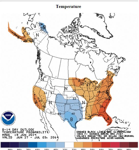
A cool end of the month for Texas:

Image
0 likes   

User avatar
South Texas Storms
Professional-Met
Professional-Met
Posts: 4224
Joined: Thu Jun 24, 2010 12:28 am
Location: Houston, TX

Re:

#156 Postby South Texas Storms » Thu Jun 19, 2014 6:02 pm

hriverajr wrote:BTW HRR has that MCV falling apart in the next couple of hours, lets just see if it does. It has weakened a bit as is to be expected.


The MCV is refiring thunderstorms around the center now and it is slowly moving towards Del Rio.
0 likes   

User avatar
hriverajr
Professional-Met
Professional-Met
Posts: 786
Joined: Tue Jul 19, 2005 12:16 am

Re: Texas Summer - 2014

#157 Postby hriverajr » Thu Jun 19, 2014 7:13 pm

Here in Del Rio, hoping it moves just a bit further west, want to get into that heavy "feeder" hehe
0 likes   

User avatar
Portastorm
Storm2k Moderator
Storm2k Moderator
Posts: 9914
Age: 63
Joined: Fri Jul 11, 2003 9:16 am
Location: Round Rock, TX
Contact:

Re: Texas Summer - 2014

#158 Postby Portastorm » Fri Jun 20, 2014 6:46 am

hriverajr wrote:Here in Del Rio, hoping it moves just a bit further west, want to get into that heavy "feeder" hehe


Well sir, it appears your wish was granted! Del Rio airport has received 4.24" of rain in last 24 hrs compared to the 1.71" of rain y'all received to date for the year.
0 likes   
Any forecasts under my name are to be taken with a grain of salt. Get your best forecasts from the National Weather Service and National Hurricane Center.

User avatar
Ntxw
Storm2k Moderator
Storm2k Moderator
Posts: 22784
Joined: Wed Oct 21, 2009 6:34 pm
Location: DFW, Texas

Re: Texas Summer - 2014

#159 Postby Ntxw » Fri Jun 20, 2014 9:13 am

Some impressive wet analogs are showing up within the next few weeks leading up to July 4th holiday. Heat ridge setting up over the east and northeast almost always spells unusual cooler/wetter anomalies for Texas post Solstice (i.e last year in early July). More in depth later.

WSI++ downgrade watch!
0 likes   
The above post and any post by Ntxw is NOT an official forecast and should not be used as such. It is just the opinion of the poster and may or may not be backed by sound meteorological data. It is NOT endorsed by any professional institution including Storm2k. For official information, please refer to NWS products.


  Help support Storm2K!

Help Support Storm2K


weatherdude1108
Category 5
Category 5
Posts: 4228
Joined: Tue Dec 13, 2011 1:04 pm
Location: Northwest Austin/Cedar Park, TX

Re: Texas Summer - 2014

#160 Postby weatherdude1108 » Fri Jun 20, 2014 9:25 am

Portastorm wrote:
hriverajr wrote:Here in Del Rio, hoping it moves just a bit further west, want to get into that heavy "feeder" hehe


Well sir, it appears your wish was granted! Del Rio airport has received 4.24" of rain in last 24 hrs compared to the 1.71" of rain y'all received to date for the year.

:uarrow:
I would think this should give a boost to Lake Amistad, and downstream to Falcon Lake. Been training over the Rio Grande, traveling upstream.
0 likes   


Return to “USA & Caribbean Weather”

Who is online

Users browsing this forum: No registered users and 9 guests