Texas Spring 2020
Moderator: S2k Moderators
Forum rules

The posts in this forum are NOT official forecast and should not be used as such. They are just the opinion of the poster and may or may not be backed by sound meteorological data. They are NOT endorsed by any professional institution or STORM2K.
-
Yukon Cornelius
- S2K Supporter

- Posts: 1842
- Age: 42
- Joined: Thu Dec 20, 2012 9:23 pm
- Location: Dean, TX/Westcliffe, CO
Re: Texas Spring 2020
Front obviously came in a lot faster and stronger. Woke up this morning to strong N wind with a temp of 34 and windchill of 25 and drizzle.
3 likes
#neversummer
-
vbhoutex

- Storm2k Executive

- Posts: 29147
- Age: 74
- Joined: Wed Oct 09, 2002 11:31 pm
- Location: Cypress, TX
- Contact:
Re: Texas Spring 2020
From Jeff Lindner with HCFCD:
Severe thunderstorms and heavy rainfall will be possible this afternoon into tonight.
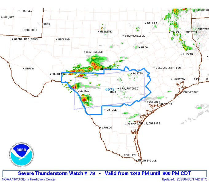
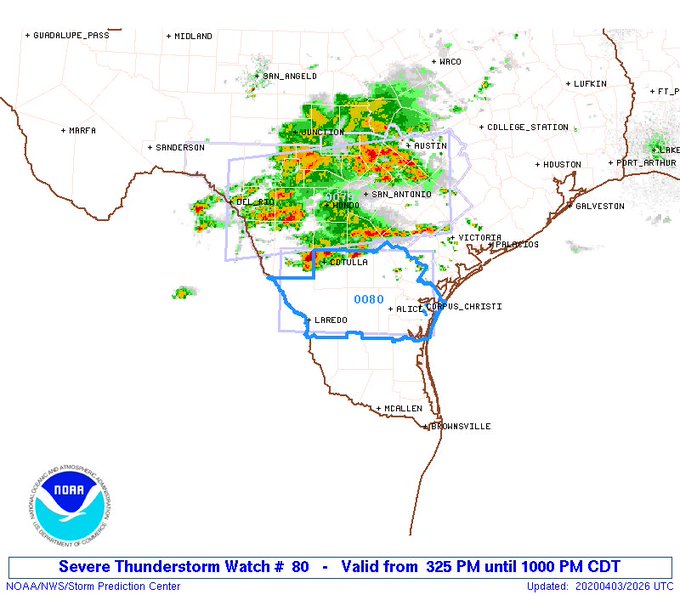
A cold front will move into the area this afternoon and stall near the coast/just offshore early Saturday. Widespread shower and thunderstorm activity is likely in association with this feature. Gulf moisture continues to increase this morning along with mid and high level moisture associated with a pronounced and active sub-tropical jet stream. There is a disturbance currently located over NC MX that will move NE and into SC TX late this morning and then into SE TX this afternoon and evening. Air mass will become moderately unstable by late morning and early afternoon from the Rio Grande plains into SC TX and the western portions of SE TX where thunderstorms will begin to develop. Some of these storms will become severe with large hail and potentially straight line damaging winds. Storms will develop upscale into lines and clusters and move across SE TX this evening. The severe threat will slowly diminish into the evening hours as instability weakens, but the threat for heavy rainfall will remain.
Surface front will reach the coast late tonight and stall near the coast or just offshore. A much colder air mass (temps in the 50’s and 60’s) will be in place on Saturday. Active jet stream will remain in place over top of the shallow surface cold pool resulting in continued active weather. Numerous showers an some thunderstorms will be possible on Saturday…mainly for areas near the coast and south of I-10. Surface front begins to wash out and move back northward as a warm front on Sunday with a continued chance of showers and thunderstorms.
Severe Threat:
SPC has outlooked the central and western portions of SE TX in a slight risk of severe weather for this afternoon and evening. The greatest risk will be along and west of a line from Huntsville to Katy to Wharton to Victoria. Severe thunderstorms will likely move out of SC/C TX this afternoon and into the western portions of SE TX. Large hail will be the main threat. Should storms form into line segments a brief severe wind threat to 60mph would be possible. Overall severe threat should lessen as storms move toward the I-45 corridor after dark as instability weakens.
Heavy Rainfall:
Factors are in place for heavy rainfall with a slow moving frontal boundary, deep moisture in place, and good lift from disturbances aloft and the sub-tropical jet. Pattern suggests periods of training storms will be possible with rainfall rates of 1-2 inches per hour. Where storms train or cluster will feature the greatest threat for heavy rainfall and any local flash flooding. Soil conditions are dry across the region and can handle 2-4 inches of rainfall without much run-off. However, rainfall rates can quickly overwhelm the ability of the soil to capture water and result in rapid run-off even with dry conditions. Rainfall totals of 1-3 inches is likely NW of a line from Liberty to Houston to Wharton with totals of 1-2 closer to the coast.
Hydro:
Widespread rain is likely over the Navasota and Brazos River basins. Both basins are already experiencing high flows from previous rainfall and upstream flood wave passages. Flooding is already ongoing along portions of the Trinity River. Additional rainfall over the next 1-2 days and then the next week will likely result in increasing flows and stages along all SE TX rivers. Some of the basins could reach or approach flood stage and those already in flood could go into moderate flooding.
Severe thunderstorms and heavy rainfall will be possible this afternoon into tonight.
A cold front will move into the area this afternoon and stall near the coast/just offshore early Saturday. Widespread shower and thunderstorm activity is likely in association with this feature. Gulf moisture continues to increase this morning along with mid and high level moisture associated with a pronounced and active sub-tropical jet stream. There is a disturbance currently located over NC MX that will move NE and into SC TX late this morning and then into SE TX this afternoon and evening. Air mass will become moderately unstable by late morning and early afternoon from the Rio Grande plains into SC TX and the western portions of SE TX where thunderstorms will begin to develop. Some of these storms will become severe with large hail and potentially straight line damaging winds. Storms will develop upscale into lines and clusters and move across SE TX this evening. The severe threat will slowly diminish into the evening hours as instability weakens, but the threat for heavy rainfall will remain.
Surface front will reach the coast late tonight and stall near the coast or just offshore. A much colder air mass (temps in the 50’s and 60’s) will be in place on Saturday. Active jet stream will remain in place over top of the shallow surface cold pool resulting in continued active weather. Numerous showers an some thunderstorms will be possible on Saturday…mainly for areas near the coast and south of I-10. Surface front begins to wash out and move back northward as a warm front on Sunday with a continued chance of showers and thunderstorms.
Severe Threat:
SPC has outlooked the central and western portions of SE TX in a slight risk of severe weather for this afternoon and evening. The greatest risk will be along and west of a line from Huntsville to Katy to Wharton to Victoria. Severe thunderstorms will likely move out of SC/C TX this afternoon and into the western portions of SE TX. Large hail will be the main threat. Should storms form into line segments a brief severe wind threat to 60mph would be possible. Overall severe threat should lessen as storms move toward the I-45 corridor after dark as instability weakens.
Heavy Rainfall:
Factors are in place for heavy rainfall with a slow moving frontal boundary, deep moisture in place, and good lift from disturbances aloft and the sub-tropical jet. Pattern suggests periods of training storms will be possible with rainfall rates of 1-2 inches per hour. Where storms train or cluster will feature the greatest threat for heavy rainfall and any local flash flooding. Soil conditions are dry across the region and can handle 2-4 inches of rainfall without much run-off. However, rainfall rates can quickly overwhelm the ability of the soil to capture water and result in rapid run-off even with dry conditions. Rainfall totals of 1-3 inches is likely NW of a line from Liberty to Houston to Wharton with totals of 1-2 closer to the coast.
Hydro:
Widespread rain is likely over the Navasota and Brazos River basins. Both basins are already experiencing high flows from previous rainfall and upstream flood wave passages. Flooding is already ongoing along portions of the Trinity River. Additional rainfall over the next 1-2 days and then the next week will likely result in increasing flows and stages along all SE TX rivers. Some of the basins could reach or approach flood stage and those already in flood could go into moderate flooding.
0 likes
Skywarn, C.E.R.T.
Please click below to donate to STORM2K to help with the expenses of keeping the site going:

Please click below to donate to STORM2K to help with the expenses of keeping the site going:
-
captainbarbossa19

- Professional-Met

- Posts: 1094
- Age: 27
- Joined: Wed Aug 21, 2019 11:09 pm
- Location: Beaumont, TX
Re: Texas Spring 2020
Cpv17 wrote:captainbarbossa19 wrote:South Texas Storms wrote:
According to the Euro Weeklies, we may dry out a bit during the second half of April. However, a wet pattern looks to return during the first half of May.
Let's start with rain first, then the drying period. I had barely over half an inch of rain for the whole month of March. Yearly rainfall now is almost 10 inches below average for my location. It's strange that the systems keep skipping the South and Southeast Texas regions. This needs to change soon or these regions are going to have a severe drought. Last time my area had severe drought conditions was probably in 2013.
Where are you located? I’m in between Wharton and El Campo and we’ve been suffering that same fate here for the most part. We had one lucky exception a couple weekends ago where we actually got almost 4”.
Cpv17, I am located between Beaumont and Houston. One thing I have noticed is that when the Austin/San Antonio area starts to get lots of rain in spring, the rains eventually tend to spread our way. Hopefully this trend holds true this year.
0 likes

Re: Texas Spring 2020
Yukon Cornelius wrote:Front obviously came in a lot faster and stronger. Woke up this morning to strong N wind with a temp of 34 and windchill of 25 and drizzle.
The horror!

3 likes
The above post and any post by dhweather is NOT an official forecast and should not be used as such. It is just the opinion of the poster and may or may not be backed by sound meteorological data. It is NOT endorsed by any professional institution including storm2k.org. For official information, please refer to NWS products.
-
ThunderSleetDreams

- S2K Supporter
- Posts: 1510
- Age: 43
- Joined: Tue Dec 20, 2011 4:42 pm
- Location: S of Weimar, TX
Re: Texas Spring 2020
Yukon Cornelius wrote:Front obviously came in a lot faster and stronger. Woke up this morning to strong N wind with a temp of 34 and windchill of 25 and drizzle.
Lucky bastard!
2 likes
#NeverSummer
I hibernate when it gets above 75 degrees!
I hibernate when it gets above 75 degrees!

Re: Texas Spring 2020
Ol Winter disappeared on us for months this year, came back to give us one last tease during April. Loved it feeling cold this morning.
1 likes
Graduate Meteorology Student at the University of Oklahoma!
All opinions independent of employers and the university.
All opinions independent of employers and the university.
-
bubba hotep

- S2K Supporter
- Posts: 6014
- Joined: Wed Dec 28, 2016 1:00 am
- Location: Collin County Texas
Re: Texas Spring 2020
Temps crashing across N. Texas with Svr Wx in S. Texas

1 likes
Winter time post are almost exclusively focused on the DFW area.
-
bubba hotep
- S2K Supporter
- Posts: 6014
- Joined: Wed Dec 28, 2016 1:00 am
- Location: Collin County Texas
-
Brent
- S2K Supporter
- Posts: 38737
- Age: 37
- Joined: Sun May 16, 2004 10:30 pm
- Location: Tulsa Oklahoma
- Contact:
Re: Texas Spring 2020
I didn't expect it to be this cold but I gotta hand it to the NAM it called it
funny we couldn't get a bust like this during those winter cold rains
funny we couldn't get a bust like this during those winter cold rains
2 likes
#neversummer
-
Haris

- Category 5

- Posts: 1814
- Joined: Mon Nov 27, 2017 8:19 pm
- Location: ( Bee Cave) West Austin, Texas
Re: Texas Spring 2020

Under a flash flood warning today.
Got nearly 2.6" at my place!
2 likes
Weather geek and a storm spotter in West Austin. Not a degreed meteorologist. Big snow fan. Love rain and cold! Despise heat!
-
bubba hotep
- S2K Supporter
- Posts: 6014
- Joined: Wed Dec 28, 2016 1:00 am
- Location: Collin County Texas
Re: Texas Spring 2020
A repeat of last night but now small storms in Southern DFW

0 likes
Winter time post are almost exclusively focused on the DFW area.
Re: Texas Spring 2020
Hearing some of the loudest thunder I have ever heard on 45 degree day. One would think it was 85 out.
2 likes
-
weatherdude1108
- Category 5
- Posts: 4228
- Joined: Tue Dec 13, 2011 1:04 pm
- Location: Northwest Austin/Cedar Park, TX
Re: Texas Spring 2020
As we here and see the daily depressing news and stats, it was 44 to 48 degrees here at the Weatherdude shut-in today. 1.5 inches of rain over the past couple days, most of that today.
Very nice!


Very nice!
2 likes
The preceding post is NOT an official forecast, and should not be used as such. It is only the opinion of the poster and may or may not be backed by sound meteorological data. It is NOT endorsed by any professional institution including storm2k.org. For Official Information please refer to the NHC and NWS products.
-
South Texas Storms

- Professional-Met
- Posts: 4256
- Joined: Thu Jun 24, 2010 12:28 am
- Location: Houston, TX
Re: Texas Spring 2020
weatherdude1108 wrote:As we here and see the daily depressing news and stats, it was 44 to 48 degrees here at the Weatherdude shut-in today. 1.5 inches of rain over the past couple days, most of that today.
Very nice!
This indeed has been a much needed rain event across much of the state, including over drought stricken south Texas! Let's hope this wet pattern sticks around for a while. It looks like it will for the upcoming week!
3 likes
-
captainbarbossa19
- Professional-Met
- Posts: 1094
- Age: 27
- Joined: Wed Aug 21, 2019 11:09 pm
- Location: Beaumont, TX
Re: Texas Spring 2020
South Texas Storms wrote:weatherdude1108 wrote:As we here and see the daily depressing news and stats, it was 44 to 48 degrees here at the Weatherdude shut-in today. 1.5 inches of rain over the past couple days, most of that today.
Very nice!
This indeed has been a much needed rain event across much of the state, including over drought stricken south Texas! Let's hope this wet pattern sticks around for a while. It looks like it will for the upcoming week!
It is very welcome! I finally got some rain out of this storm system. I had over half an inch so I am very happy. It is the perfect amount to apply fertilizer for plants!
3 likes
-
cycloneye

- Admin
- Posts: 149368
- Age: 69
- Joined: Thu Oct 10, 2002 10:54 am
- Location: San Juan, Puerto Rico
Re: Texas Spring 2020
Very good to see it's raining in the areas most needed. Hopefully,in the next drought monitor update next thursday they trim a bit the severe drought areas.
2 likes
Visit the Caribbean-Central America Weather Thread where you can find at first post web cams,radars
and observations from Caribbean basin members Click Here
and observations from Caribbean basin members Click Here
-
Haris
- Category 5
- Posts: 1814
- Joined: Mon Nov 27, 2017 8:19 pm
- Location: ( Bee Cave) West Austin, Texas
Re: Texas Spring 2020
weatherdude1108 wrote:As we here and see the daily depressing news and stats, it was 44 to 48 degrees here at the Weatherdude shut-in today. 1.5 inches of rain over the past couple days, most of that today.
Very nice!
Nice to hear from you, weatherdude
We got over 3.2" in Sw Austin. 1" came today. Hopefully the pattern continues!!
3 likes
Weather geek and a storm spotter in West Austin. Not a degreed meteorologist. Big snow fan. Love rain and cold! Despise heat!

Re: Texas Spring 2020
Happy to report 1.6” here over the past couple days in central Wharton County!!
4 likes
-
CaptinCrunch

- S2K Supporter
- Posts: 8779
- Age: 58
- Joined: Mon Nov 03, 2003 4:33 pm
- Location: Kennedale, TX (Tarrant Co.)
Re: Texas Spring 2020
Thought I would check in, hope everyone is home and healthy. Not much rain here in Tarrant Co considering the high chance rain we've had in our forecast the last few days.
Stay home and stay safe everyone, hopefully we can put this situation behind us by June.
Stay home and stay safe everyone, hopefully we can put this situation behind us by June.
3 likes
-
Ralph's Weather
- S2K Supporter
- Posts: 3371
- Age: 38
- Joined: Fri Dec 13, 2013 11:55 am
- Location: Lindale, TX
- Contact:
Re: Texas Spring 2020
Barely missed a record cold high today. Reached 51 briefly in Tyler.
0 likes
Follow on Facebook at Ralph's Weather.
Return to “USA & Caribbean Weather”
Who is online
Users browsing this forum: Stratton23 and 63 guests