Florida Weather
Moderator: S2k Moderators
Forum rules

The posts in this forum are NOT official forecast and should not be used as such. They are just the opinion of the poster and may or may not be backed by sound meteorological data. They are NOT endorsed by any professional institution or STORM2K.
-
gatorcane

- S2K Supporter

- Posts: 23708
- Age: 48
- Joined: Sun Mar 13, 2005 3:54 pm
- Location: Boca Raton, FL
Re: Florida Weather
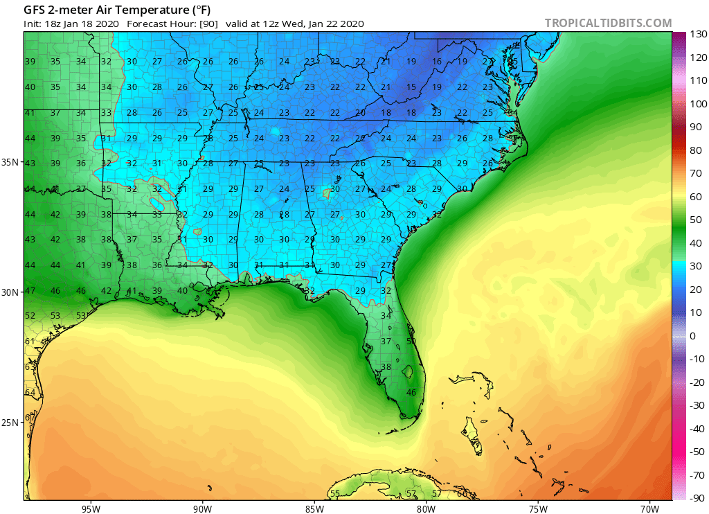
The GFS has trended slightly warmer but the Euro insists mid 30s into Central Florida including the Tampa Bay area.
1 likes

Re: Florida Weather
The Euro shows low to mid 40s in SE FL Wed AM, if it was to be correct. While the GFS shows upper 50s to low 60s.


0 likes
-
gatorcane
- S2K Supporter
- Posts: 23708
- Age: 48
- Joined: Sun Mar 13, 2005 3:54 pm
- Location: Boca Raton, FL
Re: Florida Weather
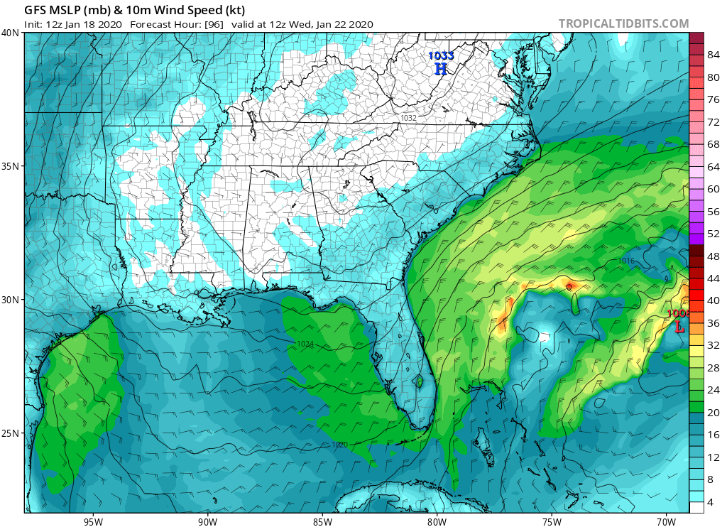
NDG wrote::uarrow: Yep, big differences between the GFS and Euro continue for Wednesday morning lows, the reason for it is that the Euro shows a stronger low pressure developing just east of the northern Bahamas and to move very slowly, showing surface winds to be more out of the NNW around the low pressure area all the way down to SE FL. The GFS shows a weaker low pressure area and it ejects it quicker than the Euro so it shows the winds becoming more out of the NNE across east central FL down to S FL, off of the warm Atlantic Ocean Wednesday morning.
The Euro shows low to mid 40s in SE FL Wed AM, if it was to be correct. While the GFS shows upper 50s to low 60s.
https://i.imgur.com/DyOZM8q.png
https://i.imgur.com/Quz34zU.png
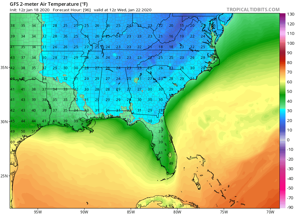
Yeah NDG that is the difference. I am watching the 12Z GFS run roll in and it looks to be succumbing to the ECMWF. The winds over Florida are more NNW to N instead of swinging around to the NNE to NE due to it trending towards showing a low pinching off the base of the trough just east of the Bahamas.
Consequently the model has dropped low temps 3-5 degrees over Florida for Tues night and is closer to the ECMWF but not as cold still. As a side interesting that Melbourne is 5 degrees warmer than parts of SE Florida.
0 likes
-
northjaxpro

- S2K Supporter
- Posts: 8900
- Joined: Mon Sep 27, 2010 11:21 am
- Location: Jacksonville, FL
Re: Florida Weather
The EURO amplifies the base of the upper trough sharply across and along the SE U.S Atlantic coast, showing a pretty significant drop with the 500 mb heights, responding to the developing Low off the coast, as Gatorcane and NDG described in their posts.
I lean to the EURO here in that temps could indeed end up being quite colder under a strong NNW flow on Monday night into Tuesday, which could funnel good advection flow deep into the Florida peninsula Tuesday-Wednesday period.
00Z runs this evening should hopefully provide much more insight on this later..
1 likes
NEVER, EVER SAY NEVER in the tropics and weather in general, and most importantly, with life itself!!
________________________________________________________________________________________
Fay 2008 Beryl 2012 Debby 2012 Colin 2016 Hermine 2016 Julia 2016 Matthew 2016 Irma 2017 Dorian 2019
________________________________________________________________________________________
Fay 2008 Beryl 2012 Debby 2012 Colin 2016 Hermine 2016 Julia 2016 Matthew 2016 Irma 2017 Dorian 2019


Re: Florida Weather
The latest NAO is no longer going negative like it was showing but slightly positive so no real change in sight.
0 likes
Re: Florida Weather
after we survive our 3 days of winter it looks like a return to our near to somewhat above normal (but not torchy) baseline. that should translate to some really pleasing sensible wx as we close out January.
0 likes
-
gatorcane
- S2K Supporter
- Posts: 23708
- Age: 48
- Joined: Sun Mar 13, 2005 3:54 pm
- Location: Boca Raton, FL
Re: Florida Weather
Latest Euro Tues night with mid 30s for Central Florida Including the Tampa Bay area (Tampa 35F and Clearwater 36F) with colder temps more on the western side of the peninsula due to the NNE wind vector moderating temps more along the east coast. Orlando metro looks to be in the upper 30s (Orlando 38F). Interestingly just a bit more east at Melbourne and we have mid 40s.
Looks like mid 40s for SE Florida.
Definitely looks to be the coldest of the season coming.

Looks like mid 40s for SE Florida.
Definitely looks to be the coldest of the season coming.
1 likes
Re: Florida Weather
0 likes
-
gatorcane
- S2K Supporter
- Posts: 23708
- Age: 48
- Joined: Sun Mar 13, 2005 3:54 pm
- Location: Boca Raton, FL
Re: Florida Weather
0 likes
Re: Florida Weather
They've got a 36 in plant city and 34 in brooksville. And this might be the best winter has to offer. We'll see
0 likes
-
FlaWeatherDude

- Tropical Storm

- Posts: 115
- Age: 41
- Joined: Wed Oct 10, 2018 2:57 pm
- Location: Orlando, FL.
Re: Florida Weather
The EPS has trended colder for early the following week!

0 likes
"Windy has wings to fly above the clouds".
-
northjaxpro
- S2K Supporter
- Posts: 8900
- Joined: Mon Sep 27, 2010 11:21 am
- Location: Jacksonville, FL
Re: Florida Weather
Here across North Florida, potential for mid-upper 20s on Tuesday morning across the Suwanee River and Big Bend areas. For Northeast Florida, upper 20s possible inland Western Duval and out to the U.S. Hwy 301 corridor, and lower 30s around the Jax metro to the mid 30s to the beaches.
NWS Jax WFO forecasting 33 degrees for the minimum on Tuesday morning for now, but I think this will trend a couple of degrees downward as I think the mets there are being a bit too conservative with this at the current time.
00Z runs will be interesting to see how much colder they could go.
NWS Jax WFO forecasting 33 degrees for the minimum on Tuesday morning for now, but I think this will trend a couple of degrees downward as I think the mets there are being a bit too conservative with this at the current time.
00Z runs will be interesting to see how much colder they could go.
1 likes
NEVER, EVER SAY NEVER in the tropics and weather in general, and most importantly, with life itself!!
________________________________________________________________________________________
Fay 2008 Beryl 2012 Debby 2012 Colin 2016 Hermine 2016 Julia 2016 Matthew 2016 Irma 2017 Dorian 2019
________________________________________________________________________________________
Fay 2008 Beryl 2012 Debby 2012 Colin 2016 Hermine 2016 Julia 2016 Matthew 2016 Irma 2017 Dorian 2019
Re: Florida Weather
2 year anniversary of the 2018 freeze is today.. we are starting another streak. That has been the only freeze since the epic winter of 2010 at KTPA.
0 likes
-
gatorcane
- S2K Supporter
- Posts: 23708
- Age: 48
- Joined: Sun Mar 13, 2005 3:54 pm
- Location: Boca Raton, FL
Re: Florida Weather
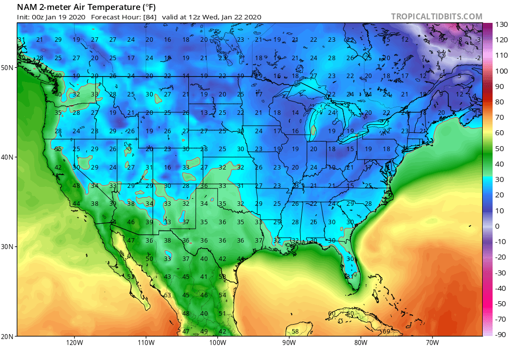
Tuesday night is now in range of the NAM which brings a freeze deep into interior peninsula Florida:
0 likes
Re: Florida Weather
I'm really curious to see how cold it gets. One thing is certain..this is going to feel insanely cold due to our recent very warm conditions. advection cold is the worst. In warm weather it's the humidity that gets you and in cold it's the wind.
0 likes
Re: Florida Weather
I cannot believe our local Fox 35 tv Met is taking the NAM serious on its 84 hr forecast, not even the GFS is calling for freezing temps for central FL. He has posted on facebook that "the risk of a freeze Wednesday morning in Orlando is real", now everyone in this area panicking.

0 likes
-
northjaxpro
- S2K Supporter
- Posts: 8900
- Joined: Mon Sep 27, 2010 11:21 am
- Location: Jacksonville, FL
Re: Florida Weather
. But the NAM could laying a blueprint showing the potential of a NW-N setting up for Monday through Wednesday morning. This set-up is the best for diving cold air down the gut of the peninsula. We will see how this will play out.
However, the trend overall though through the 00Z GFS run keeps getting colder. Looks like we will have an advective near freeze across interior North Florida as the 00Z GFS shows lower to mid 30s across much of North Florida Monday morning, and combine that with strong NW wind on Monday morning, wind chills will be down into the mid-upper 20s in some locales early on Monday. Mid-Upper 30s is èxpected around the Jacksonville area on Monday morning. It will probably be the coldest feeling thus far this season Monday for sure! Highs only in the upper 40s here on Monday shown on 00Z GFS. with strong cold air advection all day.
Tuesday morning shows generally upper 20s interior North Florida, and the low 30s at areas west and north of the Saint Johns River in Northeast Florida.
The interesting thing I noticed in the 00z run is that apparently, GFS is shoeing good cold drainage into the peninsula on primatily a NW to N flow, which cold make Wednesday morning potentially the coldest morning statewide, especially if the wind starts to lay down ny then to allow some radiational cooling. 00Z GFS is showing temps well down into the 40s down into interior South Florida on Wednesday morning.
1 likes
NEVER, EVER SAY NEVER in the tropics and weather in general, and most importantly, with life itself!!
________________________________________________________________________________________
Fay 2008 Beryl 2012 Debby 2012 Colin 2016 Hermine 2016 Julia 2016 Matthew 2016 Irma 2017 Dorian 2019
________________________________________________________________________________________
Fay 2008 Beryl 2012 Debby 2012 Colin 2016 Hermine 2016 Julia 2016 Matthew 2016 Irma 2017 Dorian 2019
Return to “USA & Caribbean Weather”
Who is online
Users browsing this forum: Cpv17 and 36 guests